B33 8LD is a postal code used within the United Kingdom for delivering mail.
Postcodes are made up of two parts. The part before the space (B33) is called the outward code. The part after the space (8LD) is called the inward code. The letters C, I, K, M, O and V are not allowed in the inward code. In addition to the inward and outward code, the postcode can be broken up into four parts:
- Postal Area. In our case B which means Birmingham.
- Postal District. In our case B33.
- Postal Sector. In our case B33 8.
- Postcode Unit. The last two letters. In our case LD.
The regional mail center for the post area B is the National Distribution Centre, which is located at Danes Way, NORTHAMPTON, NN6 7DD.
The final port of call for any post addressed to the B33 8LD postcode is the local delivery office (DO) which is KITTS GREEN DO. Here the post will be sorted ready for delivery.
The properties in the B33 8LD postcode have the street address of Fellmeadow Road
Did you know? According to the 2021 Census, the B33 8LD postcode is home to a bustling 90 residents!
It is situated within the post town of BIRMINGHAM within the old postal county of Warwickshire.
B33 8LD is within the city of Birmingham.
The B33 8LD postcode area is composed of 93.75% residential properties, 6.25% commercial properties, and 0% public properties.
According to our data. Most dwellings in B33 8LD are houses. Of these houses, most are semi-detached. The remainder are detached.
Most properties in B33 8LD are owned by the occupiers with the rest being social housing.

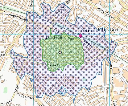
Interactive Mapping Showing UPRNs within the B33 8LD Postcode Boundaries
Use the search box to search for other postcodes or places.
| Property Type | Percentage |
|---|---|
| Residential | 93.75% |
| Commercial | 6.25% |
| Public | 0% |
Telephone Area Code for B33 8LD
The telephone area code for B33 8LD is 0121 Birmingham.
Map Coordinates for B33 8LD
| Latitude | 52.4785988923 |
|---|---|
| Longitude | -1.79012957879 |
Ordnance Survey Maps for B33 8LD
| Map Series | Amazon | Ordnance Survey |
| Explorer 1:25,000 220 Birmingham, Walsall, Solihull and Redditch | Check Price on Amazon | |
| Landranger 1:50,000 139 Birmingham and Wolverhampton | Check Price on Amazon |
Weather Forecast for B33 8LD
Mon 29th Apr
Press Button to Show Forecast for Stechford
| Time Period | Icon | Description | Temperature | Rain Probability | Wind |
|---|---|---|---|---|---|
| 21:00 to 00:00 | Cloudy | 10.0°C (feels like 8.0°C) | 4.00% | S 11 mph |
Tue 30th Apr
Press Button to Show Forecast for Stechford
| Time Period | Icon | Description | Temperature | Rain Probability | Wind |
|---|---|---|---|---|---|
| 00:00 to 03:00 | Partly cloudy (night) | 9.0°C (feels like 7.0°C) | 1.00% | SSE 11 mph | |
| 03:00 to 06:00 | Partly cloudy (night) | 8.0°C (feels like 5.0°C) | 2.00% | SSE 11 mph | |
| 06:00 to 09:00 | Sunny day | 8.0°C (feels like 5.0°C) | 2.00% | SE 9 mph | |
| 09:00 to 12:00 | Sunny day | 13.0°C (feels like 10.0°C) | 1.00% | SSE 13 mph | |
| 12:00 to 15:00 | Partly cloudy (day) | 16.0°C (feels like 12.0°C) | 5.00% | SSE 16 mph | |
| 15:00 to 18:00 | Partly cloudy (day) | 16.0°C (feels like 13.0°C) | 5.00% | SSE 13 mph | |
| 18:00 to 21:00 | Partly cloudy (day) | 14.0°C (feels like 12.0°C) | 7.00% | S 9 mph | |
| 21:00 to 00:00 | Cloudy | 11.0°C (feels like 10.0°C) | 9.00% | SSE 7 mph |
Wed 1st May
Press Button to Show Forecast for Stechford
| Time Period | Icon | Description | Temperature | Rain Probability | Wind |
|---|---|---|---|---|---|
| 00:00 to 03:00 | Cloudy | 10.0°C (feels like 9.0°C) | 11.00% | SSE 4 mph | |
| 03:00 to 06:00 | Overcast | 9.0°C (feels like 8.0°C) | 11.00% | SSE 4 mph | |
| 06:00 to 09:00 | Cloudy | 9.0°C (feels like 8.0°C) | 9.00% | SE 4 mph | |
| 09:00 to 12:00 | Overcast | 11.0°C (feels like 11.0°C) | 11.00% | SE 4 mph | |
| 12:00 to 15:00 | Cloudy | 14.0°C (feels like 13.0°C) | 13.00% | ENE 4 mph | |
| 15:00 to 18:00 | Cloudy | 15.0°C (feels like 14.0°C) | 17.00% | NE 4 mph | |
| 18:00 to 21:00 | Cloudy | 15.0°C (feels like 14.0°C) | 14.00% | NE 7 mph | |
| 21:00 to 00:00 | Cloudy | 13.0°C (feels like 11.0°C) | 12.00% | N 9 mph |
Thu 2nd May
Press Button to Show Forecast for Stechford
| Time Period | Icon | Description | Temperature | Rain Probability | Wind |
|---|---|---|---|---|---|
| 00:00 to 03:00 | Cloudy | 11.0°C (feels like 10.0°C) | 16.00% | N 9 mph | |
| 03:00 to 06:00 | Cloudy | 10.0°C (feels like 8.0°C) | 15.00% | N 9 mph | |
| 06:00 to 09:00 | Overcast | 10.0°C (feels like 8.0°C) | 14.00% | NNW 9 mph | |
| 09:00 to 12:00 | Cloudy | 12.0°C (feels like 11.0°C) | 11.00% | N 9 mph | |
| 12:00 to 15:00 | Cloudy | 16.0°C (feels like 14.0°C) | 7.00% | N 9 mph | |
| 15:00 to 18:00 | Partly cloudy (day) | 18.0°C (feels like 15.0°C) | 3.00% | N 11 mph | |
| 18:00 to 21:00 | Sunny day | 16.0°C (feels like 14.0°C) | 5.00% | N 9 mph | |
| 21:00 to 00:00 | Clear night | 13.0°C (feels like 11.0°C) | 4.00% | N 9 mph |
What are the Broadband Speeds like in the B33 8LD Postcode?
Download Speeds For B33 8LD

| Average Mbps | 157.500 |
|---|---|
| Median Mbps | 107.000 |
| Maximum Mbps | 1096.000 |
B33 8LD has an average download speed of 157.5 Megabits per second (Mbps).
261 other postcode units have the same broadband speed.
92% of postcodes (1,091,391) have slower broadband speeds.
8% of postcodes (92,989) have faster broadband speeds.
Upload Speeds For B33 8LD

| Average Mbps | 15.500 |
|---|---|
| Median Mbps | 10.000 |
| Maximum Mbps | 49.000 |
B33 8LD has an average upload speed of 15.5 Megabits per second (Mbps).
11,014 other postcode units have the same upload speed.
70% of postcodes (826,640) have slower upload speeds.
29% of postcodes (346,987) have faster upload speeds.
Schools within a five minute drive of B33 8LD Postcode
England Primary Schools
Fordbridge Community Primary School
Address: Fordbridge Community Primary School, Crabtree Drive, Chelmsley Wood, Birmingham, West Midlands, B37 5BU
Distance: 1.54 miles
Contact:
Lyndon Green Junior School
Address: Lyndon Green Junior School, Wensley Road, Sheldon, Birmingham, West Midlands, B26 1LU
Distance: 1.18 miles
Contact: 01216752983
The Oval Primary School
Address: The Oval Primary School, Whittington Oval, Yardley, Birmingham, West Midlands, B33 8JG
Distance: 0.24 miles
Contact:
Colebourne Primary School
Address: Colebourne Primary School, Stechford Road, Hodge Hill, Birmingham, West Midlands, B34 6BJ
Distance: 1.26 miles
Contact: 01216758500
St Cuthbert's RC Junior and Infant (NC) School
Address: St Cuthbert's RC Junior and Infant (NC) School, Gumbleberrys Close, Off Cotterills Lane, Stechford, Birmingham, West Midlands, B8 2PS
Distance: 1.31 miles
Contact: 01216752205
Corpus Christi Catholic Primary School
Address: Corpus Christi Catholic Primary School, Lyttelton Road, Stechford, Birmingham, West Midlands, B33 8BL
Distance: 0.95 miles
Contact: 01216752784
Blakesley Hall Primary School
Address: Blakesley Hall Primary School, Yardley Green Road, Stechford, Birmingham, West Midlands, B33 8TH
Distance: 1.12 miles
Contact: 01217832148
Stechford Primary School
Address: Stechford Primary School, Albert Road, Stechford, Birmingham, B33 8SJ
Distance: 0.97 miles
Contact: 01214643245
Thornton Primary School
Address: Thornton Primary School, Thornton Road, Ward End, Birmingham, West Midlands, B8 2LQ
Distance: 1.82 miles
Contact: 01213270824
St Bernadette's Catholic Primary School
Address: St Bernadette's Catholic Primary School, Hobmoor Road, Yardley, Birmingham, West Midlands, B25 8QL
Distance: 1.65 miles
Contact: 01217837232
Bordesley Green Primary School
Address: Bordesley Green Primary School, Marchmont Road, Birmingham, West Midlands, B9 5XX
Distance: 2.04 miles
Contact: 01217721601
The Shirestone Academy
Address: The Shirestone Academy, Shirestone Road, Tile Cross, Birmingham, West Midlands, B33 0DH
Distance: 0.97 miles
Contact: 01216754686
Our Lady's Catholic Primary School
Address: Our Lady's Catholic Primary School, East Meadway, Tile Cross, Birmingham, West Midlands, B33 0AU
Distance: 0.94 miles
Contact:
Gossey Lane Academy
Address: Gossey Lane Academy, Gossey Lane, Kitts Green, Birmingham, West Midlands, B33 0DS
Distance: 0.56 miles
Contact: 01214642909
Gossey Lane Junior Infant and Nursery School
Address: Gossey Lane Junior Infant and Nursery School, Gossey Lane, Kitts Green, Birmingham, West Midlands, B33 0DS
Distance: 0.56 miles
Contact:
Oasis Academy Blakenhale Junior
Address: Oasis Academy Blakenhale Junior, Homestead Road, Garretts Green, Birmingham, West Midlands, B33 0XG
Distance: 0.47 miles
Contact: 01217833960
Stanville Primary School
Address: Stanville Primary School, Stanville Road, Birmingham, West Midlands, B26 3YN
Distance: 1.21 miles
Contact: 01214642322
Oasis Academy Blakenhale Infants
Address: Oasis Academy Blakenhale Infants, Blakenhale Road, Garrett's Green, Birmingham, West Midlands, B33 0XD
Distance: 0.41 miles
Contact: 01217833960
Lea Forest Primary Academy
Address: Lea Forest Primary Academy, Hurstcroft Road, Kitts Green, Birmingham, B33 9RD
Distance: 0.36 miles
Contact: 01216753985
Heathlands Primary Academy
Address: Heathlands Primary Academy, Heath Way, Castle Bromwich, Birmingham, West Midlands, B34 6NB
Distance: 1.48 miles
Contact: 01217472705
Audley Primary School
Address: Audley Primary School, Audley Road, Stechford, Birmingham, West Midlands, B33 9HY
Distance: 0.67 miles
Contact: 01214643139
Audley Primary School
Address: Audley Primary School, Audley Road, Stechford, Birmingham, West Midlands, B33 9HY
Distance: 0.67 miles
Contact:
The Oval School
Address: The Oval School, Whittington Oval, Yardley, Birmingham, West Midlands, B33 8JG
Distance: 0.24 miles
Contact: 01214643248
Yardley Primary School
Address: Yardley Primary School, Harvey Road, Yardley, Birmingham, West Midlands, B26 1TD
Distance: 1.31 miles
Contact: 01214643235
Oasis Academy Hobmoor
Address: Oasis Academy Hobmoor, Wash Lane, Yardley, Birmingham, West Midlands, B25 8FD
Distance: 1.47 miles
Contact: 01216753269
Alston Primary School
Address: Alston Primary School, Alston Road, Bordesley Green East, Birmingham, West Midlands, B9 5UN
Distance: 1.69 miles
Contact: 01214641569
England Secondary Schools
CTC Kingshurst Academy
Address: CTC Kingshurst Academy, Cooks Lane, Kingshurst, Solihull, West Midlands, B37 6NU
Distance: 1.93 miles
Contact:
John Henry Newman Catholic College
Address: John Henry Newman Catholic College, Chelmsley Road, Chelmsley Wood, Birmingham, West Midlands, B37 5GA
Distance: 1.68 miles
Contact: 01217705331
Grace Academy Solihull
Address: Grace Academy Solihull, Chapelhouse Road, Chelmsey Wood, Birmingham, West Midlands, B37 5JS
Distance: 1.48 miles
Contact: 01213294600
Tile Cross Academy
Address: Tile Cross Academy, Gressel Lane, Tile Cross, Birmingham, West Midlands, B33 9UF
Distance: 0.91 miles
Contact: 01215666400
The International School
Address: The International School, Gressel Lane, Tile Cross, Birmingham, West Midlands, B33 9UF
Distance: 0.91 miles
Contact:
King Edward VI Sheldon Heath Academy
Address: King Edward VI Sheldon Heath Academy, Sheldon Heath Road, Sheldon, Birmingham, West Midlands, B26 2RZ
Distance: 0.89 miles
Contact: 01216472471
Cockshut Hill School
Address: Cockshut Hill School, Cockshut Hill, Yardley, Birmingham, West Midlands, B26 2HX
Distance: 0.72 miles
Contact: 01212895900
Cockshut Hill Technology College
Address: Cockshut Hill Technology College, Cockshut Hill, Yardley, Birmingham, West Midlands, B26 2HX
Distance: 0.72 miles
Contact:
Washwood Heath Academy
Address: Washwood Heath Academy, Burney Lane, Stechford, Birmingham, West Midlands, B8 2AS
Distance: 1.56 miles
Contact: 01216757272
Saltley Academy
Address: Saltley Academy, Belchers Lane, Bordesley Green, Birmingham, West Midlands, B9 5RX
Distance: 1.80 miles
Contact: 01215666555
Waverley School
Address: Waverley School, Yardley Green Road, Bordesley Green, Birmingham, West Midlands, B9 5QA
Distance: 1.77 miles
Contact: 01215666600
Waverley Studio College
Address: Waverley Studio College, 470 Belchers Lane, Bordesley Green, Birmingham, West Midlands, B9 5SX
Distance: 1.89 miles
Contact: 01215666622
Nearest Dentists
Dentists near B33 8LD
SHELDON DENTAL SURGERY
Address: 197 MEADWAY, BIRMINGHAM, WEST MIDLANDS, B33 8NB
Distance: 0.12 miles
Contact: :
DENTAL SURGERY
Address: 104 LEA VILLAGE, BIRMINGHAM, WEST MIDLANDS, B33 9SD
Distance: 0.48 miles
Contact: :
GLEBE FARM DENTAL CARE
Address: 21 GLEBE FARM ROAD, STECHFORD, BIRMINGHAM, WEST MIDLANDS, B33 9LY
Distance: 0.68 miles
Contact: :
RICHMOND PRIMARY CARE CENTRE
Address: 299 BORDESLEY GREEN EAST, STECHFORD, BIRMINGHAM, WEST MIDLANDS, B33 8TA
Distance: 1.15 miles
Contact: :
YEW TREE DENTAL SURGERY
Address: 529 HOB MOOR ROAD, YARDLEY, BIRMINGHAM, WEST MIDLANDS, B25 8TH
Distance: 1.23 miles
Contact: :
DENTAL SURGERY
Address: 22 MANOR HOUSE LANE, BIRMINGHAM, WEST MIDLANDS, B26 1PG
Distance: 1.23 miles
Contact: :
Nearest Chemists
Pharmacies near B33 8LD
PAN PHARMACY
Address: 91-93 PARTRIDGE ROAD, BIRMINGHAM, WEST MIDLANDS, B26 2DD
Distance: 0.32 miles
Contact: tel: 01217 861807
SAINI PHARMACY
Address: 292 KITTS GREEN ROAD, LEA VILLAGE, BIRMINGHAM, B33 9SB
Distance: 0.52 miles
Contact: tel: 01217 842448
G GOULDING LTD
Address: 119 CHURCH LANE, KITTS GREEN, STECHFORD, BIRMINGHAM, WEST MIDLANDS, B33 9EJ
Distance: 0.61 miles
Contact: :
GLEBE PHARMACY
Address: 10 GLEBE FARM ROAD, STECHFORD, BIRMINGHAM, B33 9LZ
Distance: 0.70 miles
Contact: tel: 01217 862960
PAN PHARMACY
Address: 136 GARRETTS GREEN LANE, SHELDON, BIRMINGHAM, WEST MIDLANDS, B26 2JN
Distance: 0.76 miles
Contact: tel: 01217 432082
SAINI PHARMACY
Address: 38 EAST MEADWAY, TILE CROSS, BIRMINGHAM, B33 0AP
Distance: 0.83 miles
Contact: tel: 01217 832475
Nearest Opticians
Opticians near B33 8LD
SCRIVENS OPTICIANS (LEA HALL)
Address: 300 KITTS GREEN ROAD, LEA HALL, BIRMINGHAM, WEST MIDLANDS, B33 9SB
Distance: 0.52 miles
Contact: :
ONSIGHT DOMICILIARY SERVICES LIMITED
Address: 190 FLAXLEY ROAD, BIRMINGHAM, B33 9HD
Distance: 0.69 miles
Contact: :
SPARK OPTICS STECHFORD LTD
Address: 149 STATION ROAD, STECHFORD, BIRMINGHAM, B33 8BA
Distance: 0.94 miles
Contact: :
J ELLIS OPTICIANS
Address: 146 CHURCH ROAD, YARDLEY, BIRMINGHAM, WEST MIDLANDS, B25 8UT
Distance: 1.04 miles
Contact: :
DIRECT VISION OPTICIANS
Address: 297-299 CHURCH ROAD, SHELDON, BIRMINGHAM, WEST MIDLANDS, B26 3YH
Distance: 1.19 miles
Contact: :
VISION REPUBLIC OPTICIANS
Address: 15 OWNALL ROAD, BIRMINGHAM, WEST MIDLANDS, B34 7AH
Distance: 1.21 miles
Contact: :
Nearest GP Surgeries
Doctors near B33 8LD
MIRFIELD SURGERY
Address: 287 KITTS GREEN ROAD, BIRMINGHAM, BIRMINGHAM, WEST MIDLANDS, B33 9SA
Distance: 0.48 miles
Contact: tel: 0121 4110484
ARRAN MEDICAL CENTRE BRANCH SURGERY
Address: 194 SHELDON HEATH ROAD, SHELDON, BIRMINGHAM, WEST MIDLANDS, B26 2DR
Distance: 0.49 miles
Contact: :
SHELDON HEATH ROAD SURGERY
Address: 119 SHELDON HEATH ROAD, SHELDON, BIRMINGHAM, WEST MIDLANDS, B26 2DP
Distance: 0.49 miles
Contact: tel: 01217845465
THE POOLWAY MEDICAL CENTRE
Address: CHURCH LANE HEALTH CENTRE, 80 CHURCH LANE, KITTS GREEN, BIRMINGHAM, WEST MIDLANDS, B33 9EN
Distance: 0.52 miles
Contact: tel: 0151 3308200
POOLWAY MEDICAL CENTRE
Address: 80 CHURCH LANE, KITTS GREEN, BIRMINGHAM, B33 9EN
Distance: 0.52 miles
Contact: :
CHURCH LANE - KHAN
Address: 111-113 CHURCH LANE, KITTS GREEN, STECHFORD, BIRMINGHAM, WEST MIDLANDS, B33 9EJ
Distance: 0.61 miles
Contact: tel: 0845 0711104
Transport Links near B33 8LD
Train Stations
Nearest stations for postcode: B33 8LD
- Lea Hall
Lea Hall station, Lea Hall Road, Lea Hall, West Midlands, B33 8JUDistance: 0.27 milesDriving Time: 0.91 minutes - Stechford
Stechford station, Victoria Road, Stechford, West Midlands, B33 8AJDistance: 1.42 milesDriving Time: 3.27 minutes - Marston Green
Marston Green station, Holly Lane, Marston Green, West Midlands, B37 7ABDistance: 2.19 milesDriving Time: 5.24 minutes - Acocks Green
Acocks Green station, Yardley Road, Acocks Green, West Midlands, B27 6EBDistance: 3.15 milesDriving Time: 7.44 minutes - Tyseley
Tyseley station, Wharfedale Road, Tyseley, West Midlands, B11 2HHDistance: 3.25 milesDriving Time: 7.20 minutes
Distances represent the quickest route by car.
Motorway Junctions near B33 8LD
Train Stations
Motorway Junctions near B33 8LD
Distances represent the quickest route by car.
Who are my Elected Representatives in the B33 8LD Postcode?
| Westminster Constituency | Birmingham, Yardley Boro Const |
|---|---|
| Member or Parliament |  |
| Contact Details | Contact Jess Phillips |
| Political Party | Labour |
What Council is the B33 8LD Postcode in?
The Council for this Postcode is Birmingham District Council, who are a Unitary authority. This means that they are responsible for providing education, libraries and maintaining highways as well as normal council duties such as council tax, rubbish collection, housing, environmental health and planning.
You can visit the website for Birmingham District at the following link Birmingham District.How much is the Council Tax?
Birmingham District Council is responsible for collecting council tax. This will vary depending on which council tax band the property falls within. You can check the council tax band at the gov.uk website.
Once you know the council tax band you can view how much Birmingham District charge for that band by visiting the The Council Tax section of their website.
Planning Applications
When moving house to a new post code it is worth checking out what will be built in the neighbourhood.
Few people want to live next door to a building site, have their garden overlooked or have the views from their property ruined.
Visit the local planning department and search for planning applications in this postcode granted within the last three years or still awaiting a decision. This will give an indication of what could still be built.
Where can I find out where the nearest Library to the B33 8LD Postcode is?
Libraries are the responsibility of Birmingham council
Visit the link for more information. Please note that some councils outsource library services to private companies and community groups ran by volunteers.
Libraries | Birmingham City CouncilHouse Sales in B33 8LD
| Year | High | Low | Average | Sales |
|---|---|---|---|---|
| 2011 | £130,000 | £120,000 | £125,000 | 2 |
| 2015 | £132,000 | £132,000 | £132,000 | 1 |
| 2016 | £150,000 | £150,000 | £150,000 | 1 |
| 2017 | £140,000 | £140,000 | £140,000 | 1 |
| 2022 | £250,000 | £210,000 | £230,000 | 2 |
| 2023 | £223,610 | £223,610 | £223,610 | 1 |
Contains HM Land Registry data © Crown copyright and database right 2024. This data is licensed under the Open Government Licence v3.0.
Postcodes near the B33 8LD Postcode
What Popular Supermarkets are near the B33 8LD Postcode?
| Supermarket | Distance | Directions |
|---|---|---|
| Asda, Kelynmead Road, BIRMINGHAM, B33 8LF | 0.12 miles | Directions from B33 8LD to Asda |
| Lidl, Mackadown Lane, BIRMINGHAM, B33 0NG | 1.31 miles | Directions from B33 8LD to Lidl |
| Iceland, Flaxley Parkway, Stechford Retail Park, BIRMINGHAM, B33 9AN | 1.50 miles | Directions from B33 8LD to Iceland |
| Iceland, Church Road, Yardley, BIRMINGHAM, B25 8UT | 1.67 miles | Directions from B33 8LD to Iceland |
| Aldi, Bordesley Green East, Bordesley Green, BIRMINGHAM, B9 5SP | 2.21 miles | Directions from B33 8LD to Aldi |
What Popular Restaurants are near the B33 8LD Postcode?
| Burger King | Distance | Directions |
|---|---|---|
| Fort Retail Park, Unit F1, Birmingham, B24 9FP | 2.52 miles | Directions from B33 8LD to Fort Retail Park, Unit F1 |
| 902-904 Kingsbury Road, Erdington, B24 9PY | 2.83 miles | Directions from B33 8LD to 902-904 Kingsbury Road |
| Birmingham Airport, Birmingham, B26 3QJ | 2.94 miles | Directions from B33 8LD to Birmingham Airport |
| Main Airport Terminal (airside), Birmingham, B26 3QJ | 2.98 miles | Directions from B33 8LD to Main Airport Terminal (airside) |
| Mcdonald's | Distance | Directions |
|---|---|---|
| McDonald's, Meadway, BIRMINGHAM, B33 0XH | 0.38 miles | Directions from B33 8LD to McDonald's, Meadway, BIRMINGHAM, B33 0XH |
| McDonald's, Flaxley Parkway, Stechford Retail Park, BIRMINGHAM, B33 9AN | 0.93 miles | Directions from B33 8LD to McDonald's, Flaxley Parkway, Stechford Retail Park, BIRMINGHAM, B33 9AN |
| McDonald's, Coventry Road, Yardley, BIRMINGHAM, B26 1DS | 1.40 miles | Directions from B33 8LD to McDonald's, Coventry Road, Yardley, BIRMINGHAM, B26 1DS |
| McDonald's, Belchers Lane, BIRMINGHAM, B9 5RT | 1.79 miles | Directions from B33 8LD to McDonald's, Belchers Lane, BIRMINGHAM, B9 5RT |
| Restaurant | Distance | Directions |
|---|---|---|
| KFC, Church Road, Yardley, BIRMINGHAM, B25 8UX | 1.16 miles | Directions from B33 8LD to KFC Birmingham - Yew Tree Retail Park |
| KFC, Coventry Road, Sheldon, BIRMINGHAM, B26 3JA | 1.82 miles | Directions from B33 8LD to KFC Sheldon - Coventry Road |
| KFC, Chester Road, Castle Bromwich, BIRMINGHAM, B36 0LB | 1.95 miles | Directions from B33 8LD to KFC Birmingham - Castle Bromwich |
| KFC, Moorend Avenue, BIRMINGHAM, B37 5TD | 2.19 miles | Directions from B33 8LD to KFC Birmingham - Chelmsley Wood |
| KFC, Fordrough, Yardley, BIRMINGHAM, B25 8DL | 2.34 miles | Directions from B33 8LD to KFC Birmingham - Heybarnes Retail Park |