The B33 postcode district is a postal district located in the B Birmingham postcode area with a population of 37,615 residents according to the 2021 England and Wales Census.
The area of the B33 postcode district is 3.25 square miles which is 8.41 square kilometres or 2,079.20 acres.
Currently, the B33 district has about 692 postcode units spread across 3 geographic postcode sectors.
Given that each sector allows for 400 unique postcode combinations, the district has a capacity of 1,200 postcodes. With 692 postcodes already in use, this leaves 508 units available.
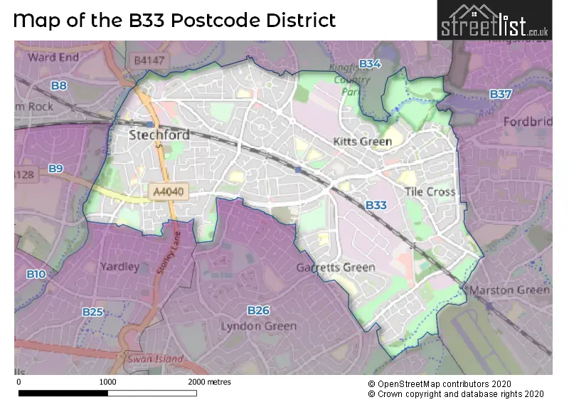
The largest settlement in the B33 postal code is BIRMINGHAM followed by Stechford, and Kitts Green.
The B33 Postcode shares a border with B37 (BIRMINGHAM, Marston Green, Birmingham Business Park), B26 (BIRMINGHAM, Sheldon, Yardley), B34 (BIRMINGHAM, Shard End, Buckland End), B25 (BIRMINGHAM, Yardley) and B9 (BIRMINGHAM, Bordesley Green, Small Heath).
The primary settlement in the B33 postcode district is Birmingham, located in the West Midlands. The most significant Postal Town in this district is Birmingham. Other significant settlements in the B33 district include Kitts Green, Stechford, and Yardley.
For the district B33, we have data on 4 postcode sectors. Here's a breakdown: The sector B33 0, covers Birmingham in West Midlands. The sector B33 3 is non-geographic. It's often designated for PO Boxes, large organisations, or special services. The sector B33 8, covers Birmingham and Stechford in West Midlands. The sector B33 9, covers Birmingham in West Midlands.


Map of the B33 Postcode District
Explore the B33 postcode district by using our free interactive map.
When it comes to local government, postal geography often disregards political borders. However, for a breakdown in the B33 District: the district mostly encompasses the Birmingham District (B) area with a total of 692 postcodes.
Weather Forecast for B33
Press Button to Show Forecast for Tile Cross
| Time Period | Icon | Description | Temperature | Rain Probability | Wind |
|---|---|---|---|---|---|
| 09:00 to 12:00 | Light rain | 7.0°C (feels like 4.0°C) | 74.00% | ENE 9 mph | |
| 12:00 to 15:00 | Overcast | 7.0°C (feels like 5.0°C) | 52.00% | NE 11 mph | |
| 15:00 to 18:00 | Overcast | 8.0°C (feels like 5.0°C) | 14.00% | NE 11 mph | |
| 18:00 to 21:00 | Overcast | 8.0°C (feels like 5.0°C) | 15.00% | NE 11 mph | |
| 21:00 to 00:00 | Overcast | 7.0°C (feels like 3.0°C) | 12.00% | NE 11 mph |
Press Button to Show Forecast for Tile Cross
| Time Period | Icon | Description | Temperature | Rain Probability | Wind |
|---|---|---|---|---|---|
| 00:00 to 03:00 | Overcast | 6.0°C (feels like 3.0°C) | 16.00% | NNE 11 mph | |
| 03:00 to 06:00 | Overcast | 5.0°C (feels like 2.0°C) | 19.00% | NNE 11 mph | |
| 06:00 to 09:00 | Light rain | 6.0°C (feels like 2.0°C) | 52.00% | N 11 mph | |
| 09:00 to 12:00 | Heavy rain | 7.0°C (feels like 4.0°C) | 73.00% | NNW 11 mph | |
| 12:00 to 15:00 | Light rain | 8.0°C (feels like 6.0°C) | 51.00% | NW 9 mph | |
| 15:00 to 18:00 | Cloudy | 10.0°C (feels like 8.0°C) | 16.00% | WNW 9 mph | |
| 18:00 to 21:00 | Cloudy | 10.0°C (feels like 8.0°C) | 10.00% | WSW 7 mph | |
| 21:00 to 00:00 | Clear night | 7.0°C (feels like 5.0°C) | 3.00% | SW 7 mph |
Press Button to Show Forecast for Tile Cross
| Time Period | Icon | Description | Temperature | Rain Probability | Wind |
|---|---|---|---|---|---|
| 00:00 to 03:00 | Clear night | 5.0°C (feels like 3.0°C) | 1.00% | SW 7 mph | |
| 03:00 to 06:00 | Clear night | 4.0°C (feels like 2.0°C) | 2.00% | SSW 7 mph | |
| 06:00 to 09:00 | Sunny day | 5.0°C (feels like 2.0°C) | 2.00% | S 7 mph | |
| 09:00 to 12:00 | Partly cloudy (day) | 10.0°C (feels like 8.0°C) | 2.00% | S 11 mph | |
| 12:00 to 15:00 | Overcast | 13.0°C (feels like 10.0°C) | 10.00% | S 13 mph | |
| 15:00 to 18:00 | Cloudy | 13.0°C (feels like 11.0°C) | 7.00% | S 13 mph | |
| 18:00 to 21:00 | Partly cloudy (day) | 12.0°C (feels like 10.0°C) | 4.00% | S 11 mph | |
| 21:00 to 00:00 | Clear night | 9.0°C (feels like 7.0°C) | 3.00% | SSE 9 mph |
Press Button to Show Forecast for Tile Cross
| Time Period | Icon | Description | Temperature | Rain Probability | Wind |
|---|---|---|---|---|---|
| 00:00 to 03:00 | Clear night | 8.0°C (feels like 5.0°C) | 3.00% | SSE 9 mph | |
| 03:00 to 06:00 | Clear night | 7.0°C (feels like 5.0°C) | 2.00% | SE 9 mph | |
| 06:00 to 09:00 | Sunny day | 8.0°C (feels like 5.0°C) | 4.00% | SE 9 mph | |
| 09:00 to 12:00 | Sunny day | 12.0°C (feels like 10.0°C) | 6.00% | SE 11 mph | |
| 12:00 to 15:00 | Partly cloudy (day) | 15.0°C (feels like 12.0°C) | 11.00% | SE 13 mph | |
| 15:00 to 18:00 | Cloudy | 15.0°C (feels like 13.0°C) | 14.00% | SE 11 mph | |
| 18:00 to 21:00 | Light rain shower (day) | 14.0°C (feels like 13.0°C) | 30.00% | SE 9 mph | |
| 21:00 to 00:00 | Cloudy | 12.0°C (feels like 10.0°C) | 12.00% | ESE 7 mph |
Where is the B33 Postcode District?
The data reveals that the postcode district B33 is located in Birmingham. It is worth noting that BIRMINGHAM is the district town. Moreover, B33 is in close proximity to several nearby towns. SOLIHULL is situated in the South West and is approximately 3.82 miles away. SUTTON COLDFIELD is located to the North at a distance of around 6.49 miles. SMETHWICK, situated to the West, is approximately 7.99 miles away. Further, ATHERSTONE, in the North East, is approximately 10.9 miles away, while WEDNESBURY, situated in the North West, is about 11.32 miles away. Lastly, B33 is around 97.57 miles away from the centre of London.
The district is within the post town of BIRMINGHAM.
The sector has postcodes within the nation of England.
The B33 Postcode District is in the Birmingham region of West Midlands within the West Midlands (England).
| Postcode Sector | Delivery Office |
|---|---|
| B33 0 | Kitts Green Delivery Office |
| B33 8 | Kitts Green Delivery Office |
| B33 9 | Kitts Green Delivery Office |
| B | 3 | 3 | - | X | X | X |
| B | 3 | 3 | Space | Numeric | Letter | Letter |
Current Monthly Rental Prices
| # Bedrooms | Min Price | Max Price | Avg Price |
|---|---|---|---|
| £595 | £775 | £685 | |
| 1 | £43 | £775 | £511 |
| 2 | £850 | £850 | £850 |
| 3 | £1,000 | £1,400 | £1,183 |
Current House Prices
| # Bedrooms | Min Price | Max Price | Avg Price |
|---|---|---|---|
| 2 | £210,000 | £210,000 | £210,000 |
| 3 | £250,000 | £420,000 | £283,500 |
| 4 | £255,000 | £450,000 | £322,000 |
| 5 | £395,000 | £395,000 | £395,000 |
| 7 | £675,000 | £675,000 | £675,000 |
| 15 | £999,999 | £999,999 | £999,999 |
Estate Agents who Operate in the B33 District
| Logo | Name | Brand Name | Address | Contact Number | Total Properties |
|---|---|---|---|---|---|
 | Stechford | YOUR MOVE Murray Rogers | 165 Station Road, Stechford, Birmingham, B33 8BA | 0121 387 6313 | 19 |
 | Sheldon | Burchell Edwards | 2208 Coventry Road, Sheldon, Birmingham, B26 3JH | 0121 387 6431 | 13 |
 | covering Birmingham | Purplebricks | Suite 7 First Floor Cranmore Drive Shirley Solihull B90 4RZ | 024 7542 7306 | 9 |
 | Yardley | Dixons | 110 Church Road, Yardley, Birmingham, West Midlands, B25 8UX | 0121 387 6293 | 7 |
 | Sheldon | Melvyn Danes | 2214 Coventry Road, Sheldon, Birmingham, B26 3JH | 0121 387 6584 | 5 |
| Type of Property | 2018 Average | 2018 Sales | 2017 Average | 2017 Sales | 2016 Average | 2016 Sales | 2015 Average | 2015 Sales |
|---|---|---|---|---|---|---|---|---|
| Detached | £269,293 | 22 | £258,777 | 11 | £214,231 | 13 | £274,500 | 14 |
| Semi-Detached | £165,835 | 169 | £147,380 | 159 | £139,424 | 163 | £124,147 | 133 |
| Terraced | £142,473 | 168 | £132,612 | 199 | £118,745 | 173 | £106,923 | 214 |
| Flats | £84,174 | 41 | £87,473 | 30 | £77,683 | 36 | £71,704 | 34 |