The B33 0 postcode sector is within the county of West Midlands.
Did you know? According to the 2021 Census, the B33 0 postcode sector is home to a bustling 11,062 residents!
Given that each sector allows for 400 unique postcode combinations. Letters C, I, K, M, O and V are not allowed in the last two letters of a postcode. With 240 postcodes already in use, this leaves 160 units available.
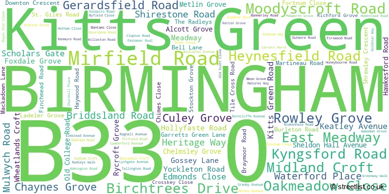
The largest settlements in the B33 0 postal code are BIRMINGHAM and Kitts Green.
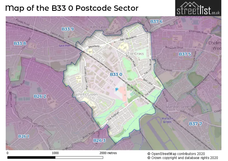
The B33 0 Postcode shares a border with B26 3 (BIRMINGHAM, Sheldon, Birmingham Airport), B33 8 (BIRMINGHAM, Stechford, Yardley), B33 9 (BIRMINGHAM, Stechford, Kitts Green), B37 6 (BIRMINGHAM, Kingshurst, Chelmsley Wood), B26 2 (BIRMINGHAM, Yardley), B37 5 (BIRMINGHAM, Fordbridge) and B37 7 (BIRMINGHAM, Marston Green, Birmingham Business Park).
The sector is within the post town of BIRMINGHAM.
B33 0 is a postcode sector within the B33 postcode district which is within the B Birmingham postcode area.
The Royal Mail delivery office for the B33 0 postal sector is the Kitts Green Delivery Office.
The area of the B33 0 postcode sector is 1.26 square miles which is 3.27 square kilometres or 808.87 square acres.

Map of the B33 0 Postcode Sector
Explore the B33 0 postcode sector by using our free interactive map.
| B | 3 | 3 | - | 0 | X | X |
| B | 3 | 3 | Space | 0 | Letter | Letter |
Official List of Streets
BIRMINGHAM (97 Streets)
Unofficial Streets or Alternative Spellings
Weather Forecast for B33 0
Press Button to Show Forecast for Tile Cross
| Time Period | Icon | Description | Temperature | Rain Probability | Wind |
|---|---|---|---|---|---|
| 09:00 to 12:00 | Light rain | 7.0°C (feels like 4.0°C) | 74.00% | ENE 9 mph | |
| 12:00 to 15:00 | Overcast | 7.0°C (feels like 5.0°C) | 52.00% | NE 11 mph | |
| 15:00 to 18:00 | Overcast | 8.0°C (feels like 5.0°C) | 14.00% | NE 11 mph | |
| 18:00 to 21:00 | Overcast | 8.0°C (feels like 5.0°C) | 15.00% | NE 11 mph | |
| 21:00 to 00:00 | Overcast | 7.0°C (feels like 3.0°C) | 12.00% | NE 11 mph |
Press Button to Show Forecast for Tile Cross
| Time Period | Icon | Description | Temperature | Rain Probability | Wind |
|---|---|---|---|---|---|
| 00:00 to 03:00 | Overcast | 6.0°C (feels like 3.0°C) | 16.00% | NNE 11 mph | |
| 03:00 to 06:00 | Overcast | 5.0°C (feels like 2.0°C) | 19.00% | NNE 11 mph | |
| 06:00 to 09:00 | Light rain | 6.0°C (feels like 2.0°C) | 52.00% | N 11 mph | |
| 09:00 to 12:00 | Heavy rain | 7.0°C (feels like 4.0°C) | 73.00% | NNW 11 mph | |
| 12:00 to 15:00 | Light rain | 8.0°C (feels like 6.0°C) | 51.00% | NW 9 mph | |
| 15:00 to 18:00 | Cloudy | 10.0°C (feels like 8.0°C) | 16.00% | WNW 9 mph | |
| 18:00 to 21:00 | Cloudy | 10.0°C (feels like 8.0°C) | 10.00% | WSW 7 mph | |
| 21:00 to 00:00 | Clear night | 7.0°C (feels like 5.0°C) | 3.00% | SW 7 mph |
Press Button to Show Forecast for Tile Cross
| Time Period | Icon | Description | Temperature | Rain Probability | Wind |
|---|---|---|---|---|---|
| 00:00 to 03:00 | Clear night | 5.0°C (feels like 3.0°C) | 1.00% | SW 7 mph | |
| 03:00 to 06:00 | Clear night | 4.0°C (feels like 2.0°C) | 2.00% | SSW 7 mph | |
| 06:00 to 09:00 | Sunny day | 5.0°C (feels like 2.0°C) | 2.00% | S 7 mph | |
| 09:00 to 12:00 | Partly cloudy (day) | 10.0°C (feels like 8.0°C) | 2.00% | S 11 mph | |
| 12:00 to 15:00 | Overcast | 13.0°C (feels like 10.0°C) | 10.00% | S 13 mph | |
| 15:00 to 18:00 | Cloudy | 13.0°C (feels like 11.0°C) | 7.00% | S 13 mph | |
| 18:00 to 21:00 | Partly cloudy (day) | 12.0°C (feels like 10.0°C) | 4.00% | S 11 mph | |
| 21:00 to 00:00 | Clear night | 9.0°C (feels like 7.0°C) | 3.00% | SSE 9 mph |
Press Button to Show Forecast for Tile Cross
| Time Period | Icon | Description | Temperature | Rain Probability | Wind |
|---|---|---|---|---|---|
| 00:00 to 03:00 | Clear night | 8.0°C (feels like 5.0°C) | 3.00% | SSE 9 mph | |
| 03:00 to 06:00 | Clear night | 7.0°C (feels like 5.0°C) | 2.00% | SE 9 mph | |
| 06:00 to 09:00 | Sunny day | 8.0°C (feels like 5.0°C) | 4.00% | SE 9 mph | |
| 09:00 to 12:00 | Sunny day | 12.0°C (feels like 10.0°C) | 6.00% | SE 11 mph | |
| 12:00 to 15:00 | Partly cloudy (day) | 15.0°C (feels like 12.0°C) | 11.00% | SE 13 mph | |
| 15:00 to 18:00 | Cloudy | 15.0°C (feels like 13.0°C) | 14.00% | SE 11 mph | |
| 18:00 to 21:00 | Light rain shower (day) | 14.0°C (feels like 13.0°C) | 30.00% | SE 9 mph | |
| 21:00 to 00:00 | Cloudy | 12.0°C (feels like 10.0°C) | 12.00% | ESE 7 mph |
Schools and Places of Education Within the B33 0 Postcode Sector
Elms Farm Community Primary School
Community school
Dorncliffe Avenue, Birmingham, West Midlands, B33 0PJ
Head: Miss Emma Baxter
Ofsted Rating: Good
Inspection: 2021-09-23 (947 days ago)
Website: Visit Elms Farm Community Primary School Website
Phone: 01214644634
Number of Pupils: 385
Gossey Lane Academy
Academy converter
Gossey Lane, Birmingham, West Midlands, B33 0DS
Head: Mrs Sarah Amin
Ofsted Rating: Requires improvement
Inspection: 2023-01-11 (472 days ago)
Website: Visit Gossey Lane Academy Website
Phone: 01214642909
Number of Pupils: 199
Hallmoor School
Academy special sponsor led
50 Scholars Gate, Birmingham, West Midlands, B33 0DL
Head: Mr Paul Donkersloot
Ofsted Rating: Good
Inspection: 2023-12-14 (135 days ago)
Website: Visit Hallmoor School Website
Phone: 01218031620
Number of Pupils: 256
Oasis Academy Blakenhale Infants
Academy sponsor led
Blakenhale Road, Birmingham, West Midlands, B33 0XD
Head: Mrs Clare Hoods-Truman
Ofsted Rating: Good
Inspection: 2022-10-12 (563 days ago)
Website: Visit Oasis Academy Blakenhale Infants Website
Phone: 01217833960
Number of Pupils: 271
Oasis Academy Blakenhale Junior
Academy sponsor led
Homestead Road, Birmingham, West Midlands, B33 0XG
Head: Mrs Clare Hoods-Truman
Ofsted Rating: Good
Inspection: 2019-07-04 (1759 days ago)
Website: Visit Oasis Academy Blakenhale Junior Website
Phone: 01217833960
Number of Pupils: 348
The Shirestone Academy
Academy sponsor led
Shirestone Road, Birmingham, West Midlands, B33 0DH
Head: Mr Nadeem Bashir
Ofsted Rating: Outstanding
Inspection: 2023-12-07 (142 days ago)
Website: Visit The Shirestone Academy Website
Phone: 01216754686
Number of Pupils: 241
House Prices in the B33 0 Postcode Sector
| Type of Property | 2018 Average | 2018 Sales | 2017 Average | 2017 Sales | 2016 Average | 2016 Sales | 2015 Average | 2015 Sales |
|---|---|---|---|---|---|---|---|---|
| Detached | £281,500 | 5 | £171,333 | 3 | £224,000 | 4 | £180,800 | 5 |
| Semi-Detached | £158,540 | 51 | £150,224 | 49 | £144,007 | 47 | £131,211 | 31 |
| Terraced | £144,120 | 58 | £144,056 | 63 | £119,991 | 62 | £108,724 | 72 |
| Flats | £79,107 | 14 | £73,000 | 9 | £77,818 | 11 | £65,731 | 13 |
Important Postcodes B33 0 in the Postcode Sector
B33 0AU is the postcode for Our Lady's Catholic Primary School, East Meadway, and OUR LADYS RC JUNIOR AND INFANT SCHOOL, EAST MEADWAY
B33 0DH is the postcode for Shirestone Academy, Shirestone Road, EDUCATION BLOCK, Shirestone Academy, Shirestone Road, SHIRESTONE PRIMARY SCHOOL, SHIRESTONE ROAD, BIRMINGHAM, and Shirestone Primary School, Shirestone Road
B33 0DL is the postcode for MODULAR CLASSROOM, Hallmoor School, Scholars Gate, The Mirfield Community and Adult Education Centre, Scholars Gate, Hallmoor School, 50 Scholars Gate, and Hallmoor School, Scholars Gate
B33 0DS is the postcode for Gossey Lane Junior & Infant School, Gossey Lane
B33 0LQ is the postcode for National Probation Service, Centenary House, and National Probation Service, Centenary House, 252 Mackadown Lane
B33 0LU is the postcode for TILE CROSS SURGERY, 144 TILE CROSS ROAD
B33 0PJ is the postcode for Elms Farm Junior & Infant School, Dorncliffe Avenue, and BIRMINGHAM CITY COUNCIL, Elms Farm Junior & Infant School, Dorncliffe Avenue
B33 0SD is the postcode for 30 GRANBY AVENUE
B33 0SE is the postcode for West Midlands Fire Service, 478 Garretts Green Lane, and West Midlands Fire Service, Fire Station, Garretts Green Lane
B33 0TD is the postcode for Birmingham City Laboratories, Phoenix House, Valepits Road, Garretts Green Trading Estate
B33 0XD is the postcode for Oasis Academy Blakenhale Infant School, Blakenhale Road, Oasis Academy Juniors, Blakenhale Road, and Oasis Academy Infants, Blakenhale Road
B33 0XG is the postcode for Oasis Academy Blakenhale, Outmore Road
| The B33 0 Sector is within these Local Authorities |
|
|---|---|
| The B33 0 Sector is within these Counties |
|
| The B33 0 Sector is within these Water Company Areas |
|