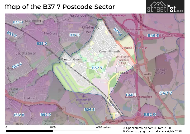
The B37 7 postcode sector stands on the West Midlands and Warwickshire border.
Did you know? According to the 2021 Census, the B37 7 postcode sector is home to a bustling 14,848 residents!
Given that each sector allows for 400 unique postcode combinations. Letters C, I, K, M, O and V are not allowed in the last two letters of a postcode. With 301 postcodes already in use, this leaves 99 units available.
The largest settlement in the B37 7 postal code is BIRMINGHAM followed by Marston Green, and Birmingham Business Park.
The B37 7 Postcode shares a border with B26 3 (BIRMINGHAM, Sheldon, Birmingham Airport), B37 6 (BIRMINGHAM, Kingshurst, Chelmsley Wood), B40 1 (BIRMINGHAM), B46 3 (Coleshill), B92 0 (Hampton-in-Arden, SOLIHULL, Barston), B33 0 (BIRMINGHAM, Kitts Green) and B37 5 (BIRMINGHAM, Fordbridge).
The sector is within the post town of BIRMINGHAM.
B37 7 is a postcode sector within the B37 postcode district which is within the B Birmingham postcode area.
The Royal Mail delivery office for the B37 7 postal sector is the Chelmsley Wood Delivery Office.
The area of the B37 7 postcode sector is 2.83 square miles which is 7.33 square kilometres or 1,811.76 square acres.
The B37 7 postcode sector is crossed by the M42 motorway.
Waterways within the B37 7 postcode sector include the River Cole.

Map of the B37 7 Postcode Sector
Explore the B37 7 postcode sector by using our free interactive map.
| B | 3 | 7 | - | 7 | X | X |
| B | 3 | 7 | Space | 7 | Letter | Letter |
Official List of Streets
BIRMINGHAM (109 Streets)
Marston Green (30 Streets)
Chelmsley Wood (9 Streets)
Birmingham Business Park (3 Streets)
Unofficial Streets or Alternative Spellings
BIRMINGHAM
BICKENHILL PARKWAY CAMBRIDGE DRIVE GLOUCESTER WAY MOOREND AVENUE WELLS WALK WINCHESTER DRIVE BISHOPS COURT BISHOPS DRIVE CLOCK ROUNDABOUT COMET ROAD EXHIBITION WAY FARNDONAVENUE FIRST EXHIBITION AVENUE HAZELTREE CROFT HERALD ROAD IVY LODGE CLOSE KINGS COURT KINVER MEWS KNIGHTS COURT MALTHOUSE ROW NORTHWAY ISLAND PERIMETER ROAD PINE SQUARE PLATFORM 1 PLATFORMS 2 AND 3 PLATFORMS 4 AND 5 PROGRESS WAY RAMP ROAD STANLEY WAY STATION LINK ROAD STATION WAY SUNDEW DRRIVE SYCAMORE CRESCENT TAXI STAND THE UNDERPASS TRIDENT ROAD TRINITY PARK VANGUARD ROAD WHITE BEAM ROADColeshill
COLESHILL HEATH ROADBirmingham Airport
AMBASSADOR ROADCastle Bromwich
CHESTER ROADBickenhill
COVENTRY ROADWeather Forecast for B37 7
Press Button to Show Forecast for Marston Green
| Time Period | Icon | Description | Temperature | Rain Probability | Wind |
|---|---|---|---|---|---|
| 06:00 to 09:00 | Cloudy | 5.0°C (feels like 2.0°C) | 9.00% | NE 7 mph | |
| 09:00 to 12:00 | Light rain | 7.0°C (feels like 4.0°C) | 54.00% | ENE 11 mph | |
| 12:00 to 15:00 | Overcast | 7.0°C (feels like 5.0°C) | 51.00% | ENE 11 mph | |
| 15:00 to 18:00 | Overcast | 8.0°C (feels like 5.0°C) | 14.00% | NE 11 mph | |
| 18:00 to 21:00 | Overcast | 8.0°C (feels like 5.0°C) | 16.00% | NE 11 mph | |
| 21:00 to 00:00 | Overcast | 7.0°C (feels like 4.0°C) | 11.00% | NE 11 mph |
Press Button to Show Forecast for Marston Green
| Time Period | Icon | Description | Temperature | Rain Probability | Wind |
|---|---|---|---|---|---|
| 00:00 to 03:00 | Overcast | 6.0°C (feels like 3.0°C) | 16.00% | NNE 11 mph | |
| 03:00 to 06:00 | Overcast | 6.0°C (feels like 2.0°C) | 19.00% | NNE 11 mph | |
| 06:00 to 09:00 | Light rain | 6.0°C (feels like 2.0°C) | 52.00% | N 11 mph | |
| 09:00 to 12:00 | Heavy rain | 7.0°C (feels like 4.0°C) | 73.00% | NNW 11 mph | |
| 12:00 to 15:00 | Light rain | 8.0°C (feels like 6.0°C) | 51.00% | NW 9 mph | |
| 15:00 to 18:00 | Cloudy | 10.0°C (feels like 8.0°C) | 16.00% | WNW 9 mph | |
| 18:00 to 21:00 | Cloudy | 10.0°C (feels like 8.0°C) | 10.00% | WSW 7 mph | |
| 21:00 to 00:00 | Clear night | 7.0°C (feels like 5.0°C) | 3.00% | SW 7 mph |
Press Button to Show Forecast for Marston Green
| Time Period | Icon | Description | Temperature | Rain Probability | Wind |
|---|---|---|---|---|---|
| 00:00 to 03:00 | Clear night | 5.0°C (feels like 3.0°C) | 1.00% | SW 7 mph | |
| 03:00 to 06:00 | Clear night | 4.0°C (feels like 2.0°C) | 2.00% | SSW 7 mph | |
| 06:00 to 09:00 | Sunny day | 5.0°C (feels like 3.0°C) | 2.00% | S 7 mph | |
| 09:00 to 12:00 | Partly cloudy (day) | 10.0°C (feels like 8.0°C) | 2.00% | S 11 mph | |
| 12:00 to 15:00 | Overcast | 13.0°C (feels like 10.0°C) | 10.00% | S 13 mph | |
| 15:00 to 18:00 | Cloudy | 13.0°C (feels like 11.0°C) | 7.00% | S 13 mph | |
| 18:00 to 21:00 | Partly cloudy (day) | 12.0°C (feels like 10.0°C) | 4.00% | S 11 mph | |
| 21:00 to 00:00 | Clear night | 9.0°C (feels like 7.0°C) | 3.00% | SSE 9 mph |
Press Button to Show Forecast for Marston Green
| Time Period | Icon | Description | Temperature | Rain Probability | Wind |
|---|---|---|---|---|---|
| 00:00 to 03:00 | Clear night | 8.0°C (feels like 5.0°C) | 3.00% | SSE 9 mph | |
| 03:00 to 06:00 | Clear night | 7.0°C (feels like 5.0°C) | 2.00% | SE 9 mph | |
| 06:00 to 09:00 | Sunny day | 8.0°C (feels like 5.0°C) | 4.00% | SE 9 mph | |
| 09:00 to 12:00 | Sunny day | 12.0°C (feels like 10.0°C) | 6.00% | SE 11 mph | |
| 12:00 to 15:00 | Partly cloudy (day) | 15.0°C (feels like 12.0°C) | 11.00% | SE 13 mph | |
| 15:00 to 18:00 | Cloudy | 16.0°C (feels like 13.0°C) | 14.00% | SE 11 mph | |
| 18:00 to 21:00 | Light rain shower (day) | 15.0°C (feels like 13.0°C) | 30.00% | SE 9 mph | |
| 21:00 to 00:00 | Cloudy | 12.0°C (feels like 10.0°C) | 12.00% | ESE 7 mph |
Schools and Places of Education Within the B37 7 Postcode Sector
Bishop Wilson Church of England Primary School
Voluntary aided school
10 Craig Croft, Birmingham, West Midlands, B37 7TR
Head: Mr Desmond Ricketts
Ofsted Rating: Good
Inspection: 2019-06-05 (1788 days ago)
Website: Visit Bishop Wilson Church of England Primary School Website
Phone: 01217704063
Number of Pupils: 444
Coleshill Heath School
Community school
Lime Grove, Birmingham, West Midlands, B37 7PY
Head: Miss Nicole Fowles
Ofsted Rating: Good
Inspection: 2021-07-15 (1017 days ago)
Website: Visit Coleshill Heath School Website
Phone: 01217798070
Number of Pupils: 579
Marston Green Infant Academy
Academy converter
Elm Farm Avenue, Birmingham, West Midlands, B37 7AA
Head: Ms Beverley Elliott
Ofsted Rating: Good
Inspection: 2019-10-16 (1655 days ago)
Website: Visit Marston Green Infant Academy Website
Phone: 01217795667
Number of Pupils: 331
Marston Green Junior School
Community school
Station Road, Birmingham, West Midlands, B37 7BA
Head: Mrs Lynn Clark
Ofsted Rating: Outstanding
Inspection: 2012-03-15 (4426 days ago)
Website: Visit Marston Green Junior School Website
Phone: 01217792227
Number of Pupils: 353
House Prices in the B37 7 Postcode Sector
| Type of Property | 2018 Average | 2018 Sales | 2017 Average | 2017 Sales | 2016 Average | 2016 Sales | 2015 Average | 2015 Sales |
|---|---|---|---|---|---|---|---|---|
| Detached | £319,344 | 52 | £319,804 | 55 | £292,295 | 47 | £287,947 | 34 |
| Semi-Detached | £207,625 | 57 | £192,640 | 63 | £203,017 | 44 | £185,719 | 46 |
| Terraced | £155,870 | 92 | £148,067 | 56 | £139,632 | 62 | £127,413 | 70 |
| Flats | £90,623 | 28 | £128,598 | 44 | £104,357 | 73 | £81,013 | 26 |
Important Postcodes B37 7 in the Postcode Sector
B37 7AA is the postcode for Marston Green Infant Academy, Elm Farm Avenue, and Marston Green Infant Academy, Elm Farm Avenue, Marston Green
B37 7BA is the postcode for Marston Green Junior School, Station Road, and Marston Green Junior School, Station Road, Marston Green
B37 7DQ is the postcode for Land Lane Clinic, Land Lane
B37 7HE is the postcode for The Better Living Centre, Unit 4, Elmdon Trading Estate, Bickenhill Lane, and Vehicle & Operator Service Agency, Unit 10, Elmdon Trading Estate, Bickenhill Lane
B37 7HL is the postcode for MALVERN UNIT, Coventry and Warwickshire Partnership NHS Trust, Brooklands Hospital, Coventry and Warwickshire Partnership NHS Trust, Brooklands Hospital, 1&3 TUXFORD AVENUE, Brooklands Hospital, Coleshill Road, BRIAN OLIVER CENTRE, BROOKLANDS HOSPITAL, MARSTON GREEN, JANET SHAW UNIT, Coventry and Warwickshire Partnership NHS Trust, Brooklands Hospital, AMBER UNIT, Coventry and Warwickshire Partnership NHS Trust, Brooklands Hospital, BRIAN OLIVER CENTRE, Coventry and Warwickshire Partnership NHS Trust, Brooklands Hospital, EDEN UNIT, Coventry and Warwickshire Partnership NHS Trust, Brooklands Hospital, and JADE UNIT, Coventry and Warwickshire Partnership NHS Trust, Brooklands Hospital
B37 7JB is the postcode for John Black Day Hospital, 2-4 Maple Leaf Drive
B37 7JT is the postcode for INFANT BUILDING, Coleshill Heath School, Marlene Croft, and JUNIOR BUILDING, Coleshill Heath School, Marlene Croft
B37 7NS is the postcode for 107, Helmswood Drive
B37 7PY is the postcode for Coleshill Heath Primary School, Lime Grove, Chelmsley Wood, Alcott Hall Junior & Infant School, Lime Grove, and Coleshill Heath Primary School, Lime Grove
B37 7RS is the postcode for Keepers Lodge, Chelmsley Road
B37 7RW is the postcode for Newington Resource Centre, Newington Road, Marston Green, and Solihull Health Care NHS Trust, Newington Resource Centre, Newington Road
B37 7TP is the postcode for Enterprise Centre, 1 Hedingham Grove
B37 7TR is the postcode for Bishop Wilson C of E Primary School, 10 Craig Croft
B37 7UR is the postcode for Middlewood House, Larch Croft, Chelmsley Wood, and Middlewood House, Larch Croft
B37 7US is the postcode for Bishop Wilson C of E Primary School, Pike Drive
B37 7WB is the postcode for Croft Medical Centre, 1 Pomeroy Way, and Croft Medical Centre, Pomeroy Way, Chelmsley Wood
| The B37 7 Sector is within these Local Authorities |
|
|---|---|
| The B37 7 Sector is within these Counties |
|
| The B37 7 Sector is within these Water Company Areas |
|