The B37 5 postcode sector is within the county of West Midlands.
Did you know? According to the 2021 Census, the B37 5 postcode sector is home to a bustling 10,353 residents!
Given that each sector allows for 400 unique postcode combinations. Letters C, I, K, M, O and V are not allowed in the last two letters of a postcode. With 209 postcodes already in use, this leaves 191 units available.
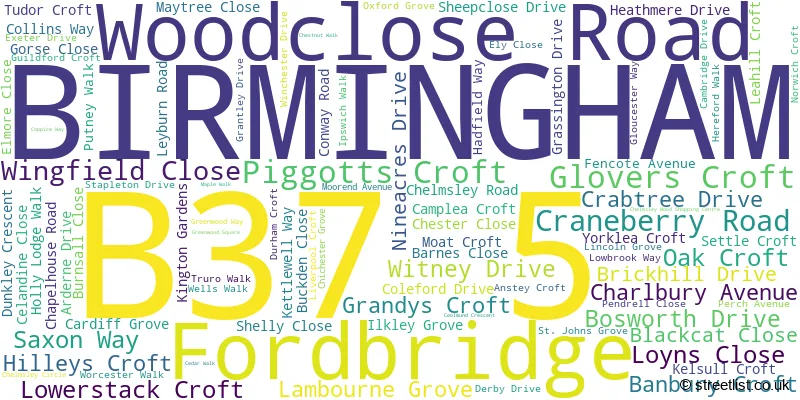
The largest settlements in the B37 5 postal code are BIRMINGHAM and Fordbridge.
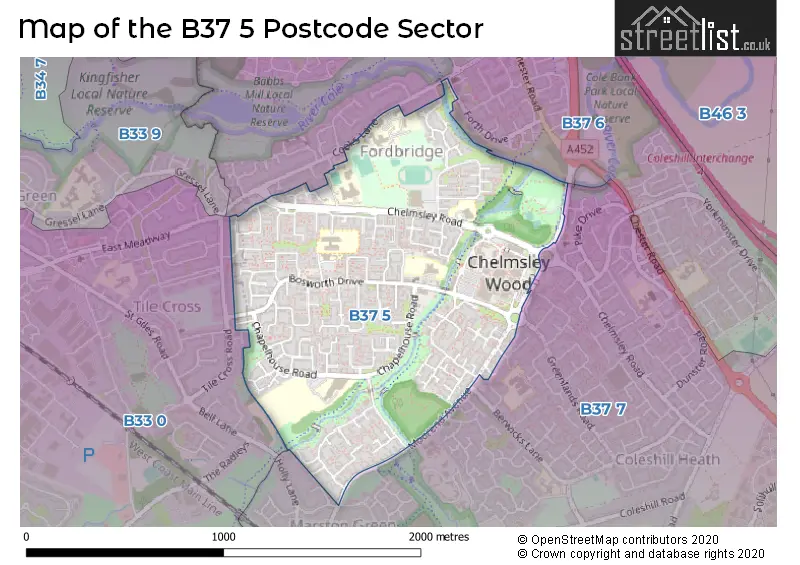
The B37 5 Postcode shares a border with B37 6 (BIRMINGHAM, Kingshurst, Chelmsley Wood), B33 0 (BIRMINGHAM, Kitts Green) and B37 7 (BIRMINGHAM, Marston Green, Birmingham Business Park).
The sector is within the post town of BIRMINGHAM.
B37 5 is a postcode sector within the B37 postcode district which is within the B Birmingham postcode area.
The Royal Mail delivery office for the B37 5 postal sector is the Chelmsley Wood Delivery Office.
The area of the B37 5 postcode sector is 0.82 square miles which is 2.13 square kilometres or 527.54 square acres.
Waterways within the B37 5 postcode sector include the River Cole.

Map of the B37 5 Postcode Sector
Explore the B37 5 postcode sector by using our free interactive map.
| B | 3 | 7 | - | 5 | X | X |
| B | 3 | 7 | Space | 5 | Letter | Letter |
Official List of Streets
Fordbridge (9 Streets)
BIRMINGHAM (81 Streets)
Unofficial Streets or Alternative Spellings
Weather Forecast for B37 5
Press Button to Show Forecast for Fordbridge
| Time Period | Icon | Description | Temperature | Rain Probability | Wind |
|---|---|---|---|---|---|
| 09:00 to 12:00 | Light rain | 7.0°C (feels like 4.0°C) | 54.00% | ENE 11 mph | |
| 12:00 to 15:00 | Light rain | 8.0°C (feels like 5.0°C) | 51.00% | NE 11 mph | |
| 15:00 to 18:00 | Overcast | 8.0°C (feels like 5.0°C) | 14.00% | NE 11 mph | |
| 18:00 to 21:00 | Overcast | 8.0°C (feels like 5.0°C) | 15.00% | NE 11 mph | |
| 21:00 to 00:00 | Overcast | 7.0°C (feels like 4.0°C) | 11.00% | NE 11 mph |
Press Button to Show Forecast for Fordbridge
| Time Period | Icon | Description | Temperature | Rain Probability | Wind |
|---|---|---|---|---|---|
| 00:00 to 03:00 | Overcast | 6.0°C (feels like 3.0°C) | 16.00% | NNE 11 mph | |
| 03:00 to 06:00 | Overcast | 6.0°C (feels like 2.0°C) | 27.00% | NNE 11 mph | |
| 06:00 to 09:00 | Light rain | 6.0°C (feels like 2.0°C) | 52.00% | N 11 mph | |
| 09:00 to 12:00 | Heavy rain | 7.0°C (feels like 4.0°C) | 73.00% | NNW 11 mph | |
| 12:00 to 15:00 | Light rain | 8.0°C (feels like 6.0°C) | 51.00% | NW 9 mph | |
| 15:00 to 18:00 | Cloudy | 10.0°C (feels like 8.0°C) | 16.00% | WNW 9 mph | |
| 18:00 to 21:00 | Cloudy | 10.0°C (feels like 8.0°C) | 10.00% | WSW 7 mph | |
| 21:00 to 00:00 | Clear night | 7.0°C (feels like 5.0°C) | 3.00% | SW 7 mph |
Press Button to Show Forecast for Fordbridge
| Time Period | Icon | Description | Temperature | Rain Probability | Wind |
|---|---|---|---|---|---|
| 00:00 to 03:00 | Clear night | 5.0°C (feels like 3.0°C) | 1.00% | SW 7 mph | |
| 03:00 to 06:00 | Clear night | 4.0°C (feels like 2.0°C) | 2.00% | SSW 7 mph | |
| 06:00 to 09:00 | Sunny day | 5.0°C (feels like 3.0°C) | 2.00% | S 7 mph | |
| 09:00 to 12:00 | Partly cloudy (day) | 10.0°C (feels like 8.0°C) | 2.00% | S 11 mph | |
| 12:00 to 15:00 | Overcast | 13.0°C (feels like 10.0°C) | 10.00% | S 13 mph | |
| 15:00 to 18:00 | Cloudy | 13.0°C (feels like 11.0°C) | 7.00% | S 13 mph | |
| 18:00 to 21:00 | Partly cloudy (day) | 12.0°C (feels like 10.0°C) | 4.00% | S 11 mph | |
| 21:00 to 00:00 | Clear night | 9.0°C (feels like 7.0°C) | 3.00% | SSE 9 mph |
Press Button to Show Forecast for Fordbridge
| Time Period | Icon | Description | Temperature | Rain Probability | Wind |
|---|---|---|---|---|---|
| 00:00 to 03:00 | Clear night | 8.0°C (feels like 5.0°C) | 3.00% | SSE 9 mph | |
| 03:00 to 06:00 | Clear night | 7.0°C (feels like 5.0°C) | 2.00% | SE 9 mph | |
| 06:00 to 09:00 | Sunny day | 8.0°C (feels like 5.0°C) | 4.00% | SE 9 mph | |
| 09:00 to 12:00 | Sunny day | 12.0°C (feels like 10.0°C) | 6.00% | SE 11 mph | |
| 12:00 to 15:00 | Partly cloudy (day) | 15.0°C (feels like 12.0°C) | 11.00% | SE 13 mph | |
| 15:00 to 18:00 | Cloudy | 16.0°C (feels like 13.0°C) | 14.00% | SE 11 mph | |
| 18:00 to 21:00 | Light rain shower (day) | 15.0°C (feels like 13.0°C) | 30.00% | SE 9 mph | |
| 21:00 to 00:00 | Cloudy | 12.0°C (feels like 10.0°C) | 12.00% | ESE 7 mph |
Schools and Places of Education Within the B37 5 Postcode Sector
Grace Academy Solihull
Academy sponsor led
Chapelhouse Road, Birmingham, West Midlands, B37 5JS
Head: Mr Darren Gelder
Ofsted Rating: Good
Inspection: 2022-05-05 (723 days ago)
Website: Visit Grace Academy Solihull Website
Phone: 01213294600
Number of Pupils: 899
John Henry Newman Catholic College
Academy sponsor led
Chelmsley Road, Birmingham, West Midlands, B37 5GA
Head: Mrs Katherine Clarke
Ofsted Rating: Good
Inspection: 2021-11-11 (898 days ago)
Website: Visit John Henry Newman Catholic College Website
Phone: 01217705331
Number of Pupils: 1322
WMG Academy for Young Engineers (Solihull)
University technical college
Chelmsley Road, Birmingham, , B37 5FD
Head: Mr Stewart Tait
Ofsted Rating: Good
Inspection: 2019-02-28 (1885 days ago)
Website: Visit WMG Academy for Young Engineers (Solihull) Website
Phone: 01212893556
Number of Pupils: 439
House Prices in the B37 5 Postcode Sector
| Type of Property | 2018 Average | 2018 Sales | 2017 Average | 2017 Sales | 2016 Average | 2016 Sales | 2015 Average | 2015 Sales |
|---|---|---|---|---|---|---|---|---|
| Detached | £226,875 | 12 | £215,667 | 3 | £227,000 | 3 | £197,700 | 5 |
| Semi-Detached | £192,636 | 32 | £161,794 | 19 | £155,421 | 19 | £140,619 | 21 |
| Terraced | £141,539 | 84 | £141,866 | 59 | £120,310 | 76 | £111,261 | 57 |
| Flats | £99,734 | 19 | £88,925 | 14 | £78,917 | 15 | £68,026 | 17 |
Important Postcodes B37 5 in the Postcode Sector
B37 5AB is the postcode for Bennetts Well Junior & Infant School, Woodclose Road
B37 5BU is the postcode for Chelmsley Wood Primary Care Centre, Crabtree Drive, and Fordbridge Primary School, Crabtree Drive
B37 5DD is the postcode for St Anne?s Catholic Primary, Nineacres Drive, and St. Anne's Catholic Primary School, Nineacres Drive
B37 5DP is the postcode for 291, Bosworth Drive, St. Annes Catholic Primary School, Bosworth Drive, and COLEBROOK RESPITE, 291 BOSWORTH DRIVE, FORDBRIDGE
B37 5EG is the postcode for Hatchford Community Primary School, Yorklea Croft, INFANT BUILDING, Hatchford Community Primary School, Yorklea Croft, JUNIOR BUILDING, Hatchford Community Primary School, Yorklea Croft, INFANT BUILDING ,, Fordbridge Community School, Yorklea Croft, and JUNIOR BUILDING ,, Fordbridge Community School, Yorklea Croft
B37 5JS is the postcode for Grace Academy, Chapelhouse Road
B37 5LA is the postcode for North Solihull Sports Centre, Conway Road, Fordbridge, and North Solihull Sports Centre, Conway Road
B37 5RA is the postcode for 1 Stephenson Drive
B37 5RY is the postcode for Brian Oliver Centre, Moorend Ave
B37 5TH is the postcode for Jobcentre Plus, 1 Chelmsley Circle, and 1 Chelmsley Circle
B37 5TN is the postcode for S M B C, Chelmsley Wood Library, 10 West Mall, Chelmsley Wood Shopping Centre, and Solihull Connect at The Bluebell Centre, West Mall
B37 5TS is the postcode for 16 - 18 Maple Walk, Chelmsley Wood
B37 5UB is the postcode for West Midlands Police, Ceolmund Crescent
| The B37 5 Sector is within these Local Authorities |
|
|---|---|
| The B37 5 Sector is within these Counties |
|
| The B37 5 Sector is within these Water Company Areas |
|