The B33 9 postcode sector is within the county of West Midlands.
Did you know? According to the 2021 Census, the B33 9 postcode sector is home to a bustling 12,802 residents!
Given that each sector allows for 400 unique postcode combinations. Letters C, I, K, M, O and V are not allowed in the last two letters of a postcode. With 224 postcodes already in use, this leaves 176 units available.
The largest settlement in the B33 9 postal code is BIRMINGHAM followed by Stechford, and Kitts Green.
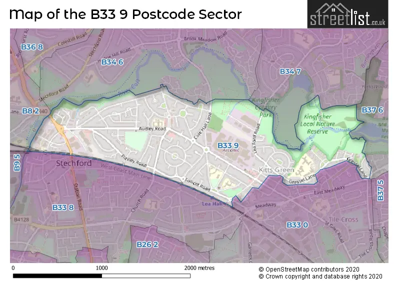
The B33 9 Postcode shares a border with B9 5 (BIRMINGHAM, Small Heath, Bordesley Green), B33 8 (BIRMINGHAM, Stechford, Yardley), B34 7 (BIRMINGHAM), B37 6 (BIRMINGHAM, Kingshurst, Chelmsley Wood), B8 2 (BIRMINGHAM, Washwood Heath, Ward End), B8 3 (BIRMINGHAM, Saltley, Alum Rock), B33 0 (BIRMINGHAM, Kitts Green) and B34 6 (BIRMINGHAM, Shard End, Buckland End).
The sector is within the post town of BIRMINGHAM.
B33 9 is a postcode sector within the B33 postcode district which is within the B Birmingham postcode area.
The Royal Mail delivery office for the B33 9 postal sector is the Kitts Green Delivery Office.
The area of the B33 9 postcode sector is 1.13 square miles which is 2.92 square kilometres or 722.77 square acres.
Waterways within the B33 9 postcode sector include the River Cole.

Map of the B33 9 Postcode Sector
Explore the B33 9 postcode sector by using our free interactive map.
| B | 3 | 3 | - | 9 | X | X |
| B | 3 | 3 | Space | 9 | Letter | Letter |
Official List of Streets
Stechford (5 Streets)
BIRMINGHAM (86 Streets)
Kitts Green (3 Streets)
Unofficial Streets or Alternative Spellings
BIRMINGHAM
COOKS LANE DOWNTON CRESCENT GREETVILLE CLOSE GRESWOLD GARDENS HAWKESFORD ROAD HEYNESFIELD ROAD HILL HOUSE LANE KENDRICK AVENUE KYNGSFORD ROAD MARTINEAU ROAD MIDDLE LEAFORD MIRFIELD ROAD MOODYSCROFT ROAD OLD FARM CLOSE PACKINGTON AVENUE YOCKLETON ROAD FLAXLEY CLOSE FLAXLEY PARKWAY IRON LANE OLD COLE HALL LANE OLD STATION ROADYardley
CHURCH ROADWeather Forecast for B33 9
Press Button to Show Forecast for Shard End
| Time Period | Icon | Description | Temperature | Rain Probability | Wind |
|---|---|---|---|---|---|
| 00:00 to 03:00 | Heavy rain | 6.0°C (feels like 2.0°C) | 86.00% | NNE 13 mph | |
| 03:00 to 06:00 | Heavy rain | 6.0°C (feels like 1.0°C) | 93.00% | N 16 mph | |
| 06:00 to 09:00 | Heavy rain | 5.0°C (feels like 1.0°C) | 94.00% | NNW 16 mph | |
| 09:00 to 12:00 | Heavy rain | 5.0°C (feels like 1.0°C) | 89.00% | NW 13 mph | |
| 12:00 to 15:00 | Heavy rain | 6.0°C (feels like 3.0°C) | 79.00% | WNW 13 mph | |
| 15:00 to 18:00 | Cloudy | 9.0°C (feels like 6.0°C) | 46.00% | W 11 mph | |
| 18:00 to 21:00 | Cloudy | 10.0°C (feels like 8.0°C) | 6.00% | WSW 9 mph | |
| 21:00 to 00:00 | Clear night | 7.0°C (feels like 5.0°C) | 0.00% | SW 7 mph |
Press Button to Show Forecast for Shard End
| Time Period | Icon | Description | Temperature | Rain Probability | Wind |
|---|---|---|---|---|---|
| 00:00 to 03:00 | Clear night | 5.0°C (feels like 3.0°C) | 0.00% | SSW 9 mph | |
| 03:00 to 06:00 | Clear night | 5.0°C (feels like 2.0°C) | 0.00% | SSW 7 mph | |
| 06:00 to 09:00 | Sunny day | 5.0°C (feels like 2.0°C) | 1.00% | S 9 mph | |
| 09:00 to 12:00 | Partly cloudy (day) | 10.0°C (feels like 8.0°C) | 2.00% | S 13 mph | |
| 12:00 to 15:00 | Cloudy | 13.0°C (feels like 10.0°C) | 7.00% | S 16 mph | |
| 15:00 to 18:00 | Cloudy | 14.0°C (feels like 11.0°C) | 7.00% | S 16 mph | |
| 18:00 to 21:00 | Partly cloudy (day) | 13.0°C (feels like 10.0°C) | 4.00% | S 13 mph | |
| 21:00 to 00:00 | Partly cloudy (night) | 10.0°C (feels like 8.0°C) | 1.00% | SSE 11 mph |
Press Button to Show Forecast for Shard End
| Time Period | Icon | Description | Temperature | Rain Probability | Wind |
|---|---|---|---|---|---|
| 00:00 to 03:00 | Clear night | 8.0°C (feels like 6.0°C) | 2.00% | SSE 11 mph | |
| 03:00 to 06:00 | Clear night | 8.0°C (feels like 5.0°C) | 2.00% | SE 9 mph | |
| 06:00 to 09:00 | Sunny day | 8.0°C (feels like 5.0°C) | 2.00% | SE 9 mph | |
| 09:00 to 12:00 | Sunny day | 13.0°C (feels like 10.0°C) | 2.00% | SE 11 mph | |
| 12:00 to 15:00 | Partly cloudy (day) | 16.0°C (feels like 13.0°C) | 3.00% | SE 13 mph | |
| 15:00 to 18:00 | Partly cloudy (day) | 16.0°C (feels like 13.0°C) | 7.00% | SE 13 mph | |
| 18:00 to 21:00 | Partly cloudy (day) | 15.0°C (feels like 13.0°C) | 7.00% | SE 9 mph | |
| 21:00 to 00:00 | Partly cloudy (night) | 12.0°C (feels like 10.0°C) | 6.00% | SE 7 mph |
Press Button to Show Forecast for Shard End
| Time Period | Icon | Description | Temperature | Rain Probability | Wind |
|---|---|---|---|---|---|
| 00:00 to 03:00 | Cloudy | 10.0°C (feels like 9.0°C) | 9.00% | ESE 7 mph | |
| 03:00 to 06:00 | Cloudy | 10.0°C (feels like 9.0°C) | 13.00% | E 4 mph | |
| 06:00 to 09:00 | Cloudy | 10.0°C (feels like 9.0°C) | 15.00% | E 4 mph | |
| 09:00 to 12:00 | Overcast | 13.0°C (feels like 12.0°C) | 16.00% | E 7 mph | |
| 12:00 to 15:00 | Cloudy | 15.0°C (feels like 14.0°C) | 17.00% | E 7 mph | |
| 15:00 to 18:00 | Cloudy | 16.0°C (feels like 15.0°C) | 36.00% | E 7 mph | |
| 18:00 to 21:00 | Cloudy | 15.0°C (feels like 14.0°C) | 18.00% | ESE 7 mph | |
| 21:00 to 00:00 | Cloudy | 13.0°C (feels like 12.0°C) | 14.00% | ESE 7 mph |
Schools and Places of Education Within the B33 9 Postcode Sector
Audley Primary School
Academy converter
Audley Road, Birmingham, West Midlands, B33 9HY
Head: Miss Joanne Harris
Ofsted Rating: Good
Inspection: 2023-06-21 (312 days ago)
Website: Visit Audley Primary School Website
Phone: 01214643139
Number of Pupils: 847
Blackwater Academy
Other independent school
14 Riverside Drive, Birmingham, , B33 9BF
Head: Mr KYLE MORRISON
Ofsted Rating: Good
Inspection: 2022-04-28 (731 days ago)
Website: Visit Blackwater Academy Website
Phone: 01212380758
Number of Pupils: 22
Lea Forest Primary Academy
Academy sponsor led
Hurstcroft Road, Birmingham, , B33 9RD
Head: Mr Craig Clarke-Castello
Ofsted Rating: Outstanding
Inspection: 2022-12-08 (507 days ago)
Website: Visit Lea Forest Primary Academy Website
Phone: 01216753985
Number of Pupils: 559
Lea Hall Academy
Academy special sponsor led
Hallmoor Road, Birmingham, West Midlands, B33 9QY
Head: Mr Stephen Garside
Ofsted Rating: Special Measures
Inspection: 2023-07-12 (291 days ago)
Website: Visit Lea Hall Academy Website
Phone: 01215940890
Number of Pupils: 81
Riverside Education
Other independent school
2 Riverside Drive, Birmingham, West Midlands, B33 9BF
Head: Dr Abide Zenenga
Ofsted Rating: Outstanding
Inspection: 2023-06-22 (311 days ago)
Website: Visit Riverside Education Website
Phone: 01216782942
Number of Pupils: 98
Tile Cross Academy
Academy sponsor led
Gressel Lane, Birmingham, West Midlands, B33 9UF
Head: Mr Paul Marano
Ofsted Rating: Requires improvement
Inspection: 2021-10-20 (921 days ago)
Website: Visit Tile Cross Academy Website
Phone: 01215666400
Number of Pupils: 595
House Prices in the B33 9 Postcode Sector
| Type of Property | 2018 Average | 2018 Sales | 2017 Average | 2017 Sales | 2016 Average | 2016 Sales | 2015 Average | 2015 Sales |
|---|---|---|---|---|---|---|---|---|
| Detached | £0 | 0 | £295,000 | 1 | £171,600 | 5 | £175,000 | 1 |
| Semi-Detached | £148,624 | 49 | £127,908 | 50 | £126,363 | 55 | £110,218 | 51 |
| Terraced | £138,767 | 71 | £122,162 | 85 | £111,280 | 73 | £104,726 | 95 |
| Flats | £93,293 | 7 | £102,000 | 4 | £79,729 | 7 | £75,056 | 8 |
Important Postcodes B33 9 in the Postcode Sector
B33 9DZ is the postcode for Ruby Rhydderch E P H, 2 Ipstones Avenue
B33 9EJ is the postcode for Church Lane Medical Centre, 111 Church Lane
B33 9EN is the postcode for Church Lane Health Centre, Church Lane
B33 9HY is the postcode for Audley Primary School, Audley Road, Audley Junior School, Audley Road, and Audley Infant School, Audley Road
B33 9QS is the postcode for Royal Mail, Kitts Green Delivery Office, 120 Kitts Green Road
B33 9QY is the postcode for Hallmoor School, Hallmoor Road, and Lea Hall Academy, Hallmoor Road
B33 9RB is the postcode for Kitts Green Community Day Nursery, 45 Ridpool Road
B33 9RD is the postcode for Lea Forest Academy, Hurstcroft Road
B33 9UF is the postcode for KENRICK BUILDING, Tile Cross Academy, Gressel Lane, MARTINEAU BUILDING, Tile Cross Academy, Gressel Lane, KENRICK BUILDING, The International School & Community College, Gressel Lane, and LEYCROFT BUILDING, Tile Cross Academy, Gressel Lane
| The B33 9 Sector is within these Local Authorities |
|
|---|---|
| The B33 9 Sector is within these Counties |
|
| The B33 9 Sector is within these Water Company Areas |
|