The B26 3 postcode sector is within the county of West Midlands.
Did you know? According to the 2021 Census, the B26 3 postcode sector is home to a bustling 11,208 residents!
Given that each sector allows for 400 unique postcode combinations. Letters C, I, K, M, O and V are not allowed in the last two letters of a postcode. With 212 postcodes already in use, this leaves 188 units available.
The largest settlement in the B26 3 postal code is BIRMINGHAM followed by Sheldon, and Birmingham Airport.
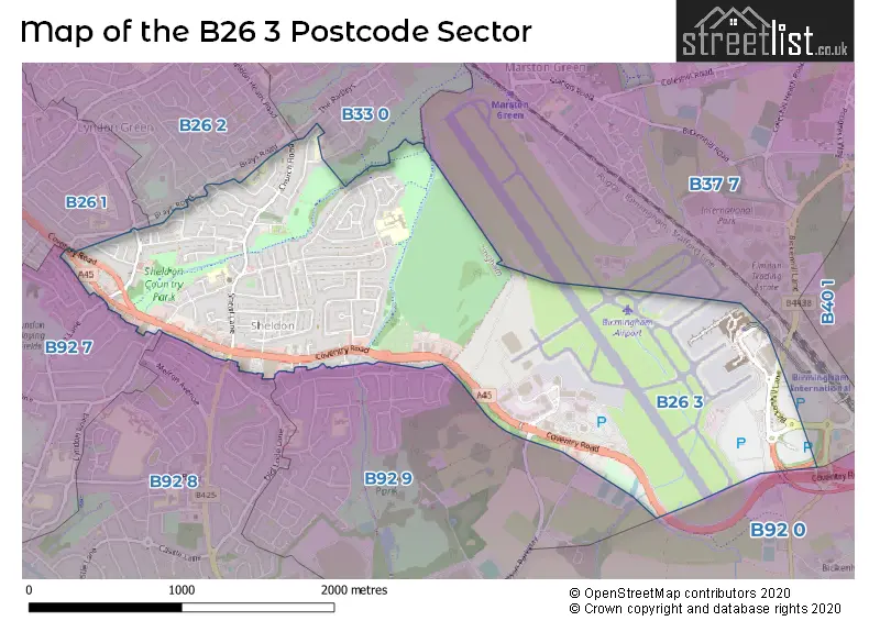
The B26 3 Postcode shares a border with B92 0 (Hampton-in-Arden, SOLIHULL, Barston), B92 7 (SOLIHULL), B26 1 (BIRMINGHAM, Yardley), B26 2 (BIRMINGHAM, Yardley), B33 0 (BIRMINGHAM, Kitts Green), B37 7 (BIRMINGHAM, Marston Green, Birmingham Business Park), B92 8 (SOLIHULL) and B92 9 (SOLIHULL).
The sector is within the post town of BIRMINGHAM.
B26 3 is a postcode sector within the B26 postcode district which is within the B Birmingham postcode area.
The Royal Mail delivery office for the B26 3 postal sector is the Redfern Park Delivery Office.
The area of the B26 3 postcode sector is 2.08 square miles which is 5.38 square kilometres or 1,328.68 square acres.

Map of the B26 3 Postcode Sector
Explore the B26 3 postcode sector by using our free interactive map.
| B | 2 | 6 | - | 3 | X | X |
| B | 2 | 6 | Space | 3 | Letter | Letter |
Official List of Streets
Birmingham Airport (8 Streets)
BIRMINGHAM (73 Streets)
Sheldon (9 Streets)
Elmdon (1 Streets)
Unofficial Streets or Alternative Spellings
BIRMINGHAM
BICKENHILL LANE BRAYS ROAD TALLINGTON ROAD BIRD ISLAND CENTRO WAY COMET ROAD FORWARD ROAD HANGAR ROAD HERMES ROAD HOBS MOAT ROAD JETSTREAM ROAD OAKS TRIDENT ROAD VANGUARD ROAD VIKING ROADSOLIHULL
DAMSON PARKWAY GLENCROFT ROAD GOODWAY ROAD KESWICK ROAD LYNDON ROAD OLD DAMSON LANE WELLS ROADBIRMINGHAM,
WAGON LANEBickenhill
COVENTRY ROADWeather Forecast for B26 3
Press Button to Show Forecast for Sheldon
| Time Period | Icon | Description | Temperature | Rain Probability | Wind |
|---|---|---|---|---|---|
| 12:00 to 15:00 | Overcast | 7.0°C (feels like 4.0°C) | 51.00% | NE 11 mph | |
| 15:00 to 18:00 | Overcast | 8.0°C (feels like 5.0°C) | 14.00% | NE 11 mph | |
| 18:00 to 21:00 | Overcast | 8.0°C (feels like 5.0°C) | 16.00% | NE 11 mph | |
| 21:00 to 00:00 | Overcast | 7.0°C (feels like 4.0°C) | 12.00% | NE 11 mph |
Press Button to Show Forecast for Sheldon
| Time Period | Icon | Description | Temperature | Rain Probability | Wind |
|---|---|---|---|---|---|
| 00:00 to 03:00 | Overcast | 6.0°C (feels like 3.0°C) | 16.00% | NNE 11 mph | |
| 03:00 to 06:00 | Overcast | 6.0°C (feels like 2.0°C) | 19.00% | NNE 11 mph | |
| 06:00 to 09:00 | Light rain | 6.0°C (feels like 2.0°C) | 52.00% | N 11 mph | |
| 09:00 to 12:00 | Heavy rain | 7.0°C (feels like 4.0°C) | 73.00% | NNW 11 mph | |
| 12:00 to 15:00 | Light rain | 8.0°C (feels like 6.0°C) | 51.00% | NW 9 mph | |
| 15:00 to 18:00 | Cloudy | 10.0°C (feels like 8.0°C) | 16.00% | WNW 9 mph | |
| 18:00 to 21:00 | Cloudy | 10.0°C (feels like 8.0°C) | 10.00% | WSW 7 mph | |
| 21:00 to 00:00 | Clear night | 7.0°C (feels like 5.0°C) | 3.00% | SW 7 mph |
Press Button to Show Forecast for Sheldon
| Time Period | Icon | Description | Temperature | Rain Probability | Wind |
|---|---|---|---|---|---|
| 00:00 to 03:00 | Clear night | 5.0°C (feels like 3.0°C) | 1.00% | SW 7 mph | |
| 03:00 to 06:00 | Clear night | 4.0°C (feels like 2.0°C) | 2.00% | SSW 7 mph | |
| 06:00 to 09:00 | Sunny day | 5.0°C (feels like 2.0°C) | 2.00% | S 7 mph | |
| 09:00 to 12:00 | Partly cloudy (day) | 10.0°C (feels like 8.0°C) | 2.00% | S 11 mph | |
| 12:00 to 15:00 | Overcast | 13.0°C (feels like 10.0°C) | 10.00% | S 13 mph | |
| 15:00 to 18:00 | Cloudy | 13.0°C (feels like 11.0°C) | 7.00% | S 13 mph | |
| 18:00 to 21:00 | Partly cloudy (day) | 12.0°C (feels like 10.0°C) | 4.00% | S 11 mph | |
| 21:00 to 00:00 | Clear night | 9.0°C (feels like 7.0°C) | 3.00% | SSE 9 mph |
Press Button to Show Forecast for Sheldon
| Time Period | Icon | Description | Temperature | Rain Probability | Wind |
|---|---|---|---|---|---|
| 00:00 to 03:00 | Clear night | 8.0°C (feels like 5.0°C) | 3.00% | SSE 9 mph | |
| 03:00 to 06:00 | Clear night | 7.0°C (feels like 5.0°C) | 2.00% | SE 9 mph | |
| 06:00 to 09:00 | Sunny day | 8.0°C (feels like 5.0°C) | 4.00% | SE 9 mph | |
| 09:00 to 12:00 | Sunny day | 12.0°C (feels like 10.0°C) | 6.00% | SE 11 mph | |
| 12:00 to 15:00 | Partly cloudy (day) | 15.0°C (feels like 12.0°C) | 11.00% | SE 13 mph | |
| 15:00 to 18:00 | Cloudy | 15.0°C (feels like 13.0°C) | 14.00% | SE 11 mph | |
| 18:00 to 21:00 | Light rain shower (day) | 14.0°C (feels like 13.0°C) | 30.00% | SE 9 mph | |
| 21:00 to 00:00 | Cloudy | 12.0°C (feels like 10.0°C) | 12.00% | ESE 7 mph |
Schools and Places of Education Within the B26 3 Postcode Sector
Mapledene Primary School
Community school
Mapledene Road, Birmingham, West Midlands, B26 3XE
Head: Miss Jacqueline Stephenson
Ofsted Rating: Good
Inspection: 2022-11-16 (528 days ago)
Website: Visit Mapledene Primary School Website
Phone: 01214642881
Number of Pupils: 336
St Thomas More Catholic Primary School
Academy sponsor led
Horse Shoes Lane, Birmingham, West Midlands, B26 3HU
Head: Mr Mark McLoughlin
Ofsted Rating: Good
Inspection: 2024-01-24 (94 days ago)
Website: Visit St Thomas More Catholic Primary School Website
Phone: 01217433289
Number of Pupils: 335
Stanville Primary School
Community school
Stanville Road, Birmingham, West Midlands, B26 3YN
Head: Mr Andy Runacres
Ofsted Rating: Good
Inspection: 2023-12-14 (135 days ago)
Website: Visit Stanville Primary School Website
Phone: 01214642322
Number of Pupils: 239
House Prices in the B26 3 Postcode Sector
| Type of Property | 2018 Average | 2018 Sales | 2017 Average | 2017 Sales | 2016 Average | 2016 Sales | 2015 Average | 2015 Sales |
|---|---|---|---|---|---|---|---|---|
| Detached | £250,174 | 17 | £272,611 | 9 | £205,200 | 5 | £215,000 | 22 |
| Semi-Detached | £182,194 | 102 | £174,660 | 128 | £164,298 | 113 | £148,743 | 113 |
| Terraced | £176,270 | 30 | £156,065 | 25 | £168,938 | 24 | £153,397 | 45 |
| Flats | £114,103 | 34 | £119,905 | 32 | £104,487 | 23 | £108,482 | 28 |
Important Postcodes B26 3 in the Postcode Sector
B26 3DU is the postcode for Asylum & Immigration Tribunal, Sheldon Court, 1a Wagon Lane
B26 3HU is the postcode for St. Thomas More RC Primary School, Horse Shoes Lane, and ST THOMAS MOORES JUNIOR AND INFANTS SCHOOL, HORSE SHOES LANE, BIRMINGHAM
B26 3JS is the postcode for Doctors Surgery, 2314 Coventry Road
B26 3PY is the postcode for CLUB HOUSE, Hatchford Brook Golf Course, Coventry Road
B26 3TP is the postcode for Church Road Surgery, 90 Church Road, Sheldon
B26 3TU is the postcode for MAIN BLOCK, SHELDON COUNTRY PARK, RAGLEY DRIVE
B26 3XA is the postcode for Birmingham City Council, Silvermere Centre, Silvermere Road
B26 3XE is the postcode for MAPLEDENE PRIMARY SCHOOL, MAPLEDENE ROAD, and Birmingham City Council, Mapledene Primary School
B26 3YN is the postcode for Stanville Junior & Infant School, Stanville Road, Birmingham City Council, Stanville Primary School, and Stanville Primary School, Stanville Road
| The B26 3 Sector is within these Local Authorities |
|
|---|---|
| The B26 3 Sector is within these Counties |
|
| The B26 3 Sector is within these Water Company Areas |
|