The B44 postcode district is a postal district located in the B Birmingham postcode area with a population of 37,742 residents according to the 2021 England and Wales Census.
The area of the B44 postcode district is 2.70 square miles which is 7.00 square kilometres or 1,729.50 acres.
Currently, the B44 district has about 635 postcode units spread across 3 geographic postcode sectors.
Given that each sector allows for 400 unique postcode combinations, the district has a capacity of 1,200 postcodes. With 635 postcodes already in use, this leaves 565 units available.
The largest settlement in the B44 postal code is BIRMINGHAM followed by Great Barr, and Kingstanding.
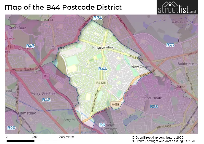
The B44 Postcode shares a border with B23 (BIRMINGHAM, Erdington), B73 (SUTTON COLDFIELD, Wylde Green) and B6 (BIRMINGHAM, Aston, Witton).
The primary settlement in the B44 postcode district is Birmingham, located in the county of West Midlands. Other significant settlements include Kingstanding and Great Barr. The most significant post town in the district is Birmingham. The county of West Midlands is located in England.
For the district B44, we have data on 3 postcode sectors. Here's a breakdown: The sector B44 0, covers Birmingham in West Midlands. The sector B44 8, covers Birmingham and Great Barr in West Midlands. The sector B44 9, covers Birmingham in West Midlands.

Map of the B44 Postcode District
Explore the B44 postcode district by using our free interactive map.
When it comes to local government, postal geography often disregards political borders. However, for a breakdown in the B44 District: the district mostly encompasses the Birmingham District (B) area with a total of 638 postcodes.
Weather Forecast for B44
Press Button to Show Forecast for Kingstanding
| Time Period | Icon | Description | Temperature | Rain Probability | Wind |
|---|---|---|---|---|---|
| 06:00 to 09:00 | Cloudy | 5.0°C (feels like 2.0°C) | 9.00% | NE 9 mph | |
| 09:00 to 12:00 | Cloudy | 7.0°C (feels like 4.0°C) | 50.00% | ENE 11 mph | |
| 12:00 to 15:00 | Overcast | 7.0°C (feels like 4.0°C) | 57.00% | ENE 11 mph | |
| 15:00 to 18:00 | Overcast | 8.0°C (feels like 5.0°C) | 16.00% | ENE 11 mph | |
| 18:00 to 21:00 | Overcast | 7.0°C (feels like 4.0°C) | 17.00% | NE 11 mph | |
| 21:00 to 00:00 | Overcast | 6.0°C (feels like 3.0°C) | 11.00% | NE 11 mph |
Press Button to Show Forecast for Kingstanding
| Time Period | Icon | Description | Temperature | Rain Probability | Wind |
|---|---|---|---|---|---|
| 00:00 to 03:00 | Overcast | 5.0°C (feels like 2.0°C) | 13.00% | NNE 11 mph | |
| 03:00 to 06:00 | Overcast | 5.0°C (feels like 1.0°C) | 19.00% | NNE 11 mph | |
| 06:00 to 09:00 | Light rain | 5.0°C (feels like 2.0°C) | 51.00% | N 11 mph | |
| 09:00 to 12:00 | Heavy rain | 6.0°C (feels like 3.0°C) | 71.00% | NNW 9 mph | |
| 12:00 to 15:00 | Overcast | 8.0°C (feels like 5.0°C) | 23.00% | NW 9 mph | |
| 15:00 to 18:00 | Overcast | 9.0°C (feels like 7.0°C) | 17.00% | WNW 9 mph | |
| 18:00 to 21:00 | Cloudy | 9.0°C (feels like 7.0°C) | 10.00% | W 7 mph | |
| 21:00 to 00:00 | Clear night | 7.0°C (feels like 5.0°C) | 3.00% | SW 7 mph |
Press Button to Show Forecast for Kingstanding
| Time Period | Icon | Description | Temperature | Rain Probability | Wind |
|---|---|---|---|---|---|
| 00:00 to 03:00 | Clear night | 5.0°C (feels like 3.0°C) | 1.00% | SW 7 mph | |
| 03:00 to 06:00 | Clear night | 4.0°C (feels like 2.0°C) | 2.00% | SSW 7 mph | |
| 06:00 to 09:00 | Partly cloudy (day) | 5.0°C (feels like 2.0°C) | 1.00% | S 7 mph | |
| 09:00 to 12:00 | Partly cloudy (day) | 10.0°C (feels like 7.0°C) | 2.00% | S 11 mph | |
| 12:00 to 15:00 | Overcast | 12.0°C (feels like 9.0°C) | 10.00% | S 13 mph | |
| 15:00 to 18:00 | Cloudy | 13.0°C (feels like 10.0°C) | 8.00% | S 13 mph | |
| 18:00 to 21:00 | Cloudy | 12.0°C (feels like 9.0°C) | 7.00% | S 11 mph | |
| 21:00 to 00:00 | Clear night | 9.0°C (feels like 7.0°C) | 3.00% | SSE 9 mph |
Press Button to Show Forecast for Kingstanding
| Time Period | Icon | Description | Temperature | Rain Probability | Wind |
|---|---|---|---|---|---|
| 00:00 to 03:00 | Clear night | 8.0°C (feels like 5.0°C) | 4.00% | SSE 9 mph | |
| 03:00 to 06:00 | Clear night | 7.0°C (feels like 4.0°C) | 3.00% | SE 9 mph | |
| 06:00 to 09:00 | Sunny day | 7.0°C (feels like 5.0°C) | 4.00% | SE 9 mph | |
| 09:00 to 12:00 | Sunny day | 12.0°C (feels like 9.0°C) | 5.00% | SE 11 mph | |
| 12:00 to 15:00 | Partly cloudy (day) | 14.0°C (feels like 12.0°C) | 12.00% | SE 13 mph | |
| 15:00 to 18:00 | Cloudy | 15.0°C (feels like 13.0°C) | 12.00% | SE 11 mph | |
| 18:00 to 21:00 | Cloudy | 14.0°C (feels like 12.0°C) | 12.00% | SE 9 mph | |
| 21:00 to 00:00 | Cloudy | 12.0°C (feels like 10.0°C) | 11.00% | ESE 7 mph |
Where is the B44 Postcode District?
The B44 postcode district is located in Birmingham. It is situated near several towns, including Sutton Coldfield, West Bromwich, Smethwick, and Walsall. Additionally, it is approximately 103.78 miles away from the center of London.
The district is within the post town of BIRMINGHAM.
The sector has postcodes within the nation of England.
The B44 Postcode District is in the Birmingham region of West Midlands within the West Midlands (England).
| Postcode Sector | Delivery Office |
|---|---|
| B44 0 | Great Barr Delivery Office |
| B44 8 | Great Barr Delivery Office |
| B44 9 | Great Barr Delivery Office |
| B | 4 | 4 | - | X | X | X |
| B | 4 | 4 | Space | Numeric | Letter | Letter |
Current Monthly Rental Prices
| # Bedrooms | Min Price | Max Price | Avg Price |
|---|---|---|---|
| 1 | £100 | £699 | £400 |
| 2 | £750 | £915 | £855 |
| 3 | £900 | £950 | £933 |
| 4 | £1,500 | £1,500 | £1,500 |
Current House Prices
| # Bedrooms | Min Price | Max Price | Avg Price |
|---|---|---|---|
| 2 | £200,000 | £279,000 | £251,333 |
| 3 | £249,995 | £310,000 | £266,666 |
| 4 | £245,000 | £370,000 | £304,000 |
| 5 | £310,000 | £360,000 | £328,333 |
Estate Agents who Operate in the B44 District
| Logo | Name | Brand Name | Address | Contact Number | Total Properties |
|---|---|---|---|---|---|
 | Kingstanding | Paul Carr | 225/227 Hawthorn Road, Kingstanding, Birmingham, B44 8PL | 0121 387 6470 | 40 |
 | Covering West Midlands | Homewise | B46 1DL | 01273 092409 | 25 |
 | Kingstanding | Dixons | 820 Kingstanding Road, Birmingham, West Midlands, B44 9RT | 0121 387 6277 | 23 |
 | Great Barr | Connells | 907 Walsall Road, Great Barr, B42 1TN | 0121 387 6334 | 8 |
 | covering Birmingham | Purplebricks | Suite 7 First Floor Cranmore Drive Shirley Solihull B90 4RZ | 024 7542 7306 | 6 |
| Type of Property | 2018 Average | 2018 Sales | 2017 Average | 2017 Sales | 2016 Average | 2016 Sales | 2015 Average | 2015 Sales |
|---|---|---|---|---|---|---|---|---|
| Detached | £178,721 | 12 | £180,750 | 12 | £211,100 | 5 | £152,611 | 9 |
| Semi-Detached | £153,499 | 294 | £141,067 | 243 | £129,898 | 248 | £122,454 | 201 |
| Terraced | £135,591 | 212 | £124,675 | 199 | £118,779 | 223 | £108,426 | 200 |
| Flats | £86,888 | 26 | £86,204 | 23 | £76,748 | 23 | £77,155 | 19 |