The B63 postcode district is a postal district located in the B Birmingham postcode area with a population of 37,145 residents according to the 2021 England and Wales Census.
The area of the B63 postcode district is 3.98 square miles which is 10.30 square kilometres or 2,545.68 acres.
Currently, the B63 district has about 784 postcode units spread across 4 geographic postcode sectors.
Given that each sector allows for 400 unique postcode combinations, the district has a capacity of 1,600 postcodes. With 784 postcodes already in use, this leaves 816 units available.
The largest settlements in the B63 postal code are HALESOWEN and Hayley Green.
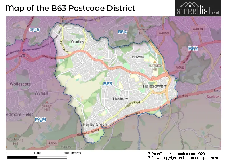
The B63 Postcode shares a border with B62 (HALESOWEN, Romsley, Hunnington), DY5 (BRIERLEY HILL, Pensnett, Quarry Bank), DY9 (STOURBRIDGE, Hagley, Belbroughton) and B64 (CRADLEY HEATH).
The B63 postcode district primarily consists of Halesowen, which is located in the West Midlands county. Other significant settlements within the district include Hasbury and Hayley Green.
For the district B63, we have data on 4 postcode sectors. Here's a breakdown: The sector B63 1, covers Halesowen and Hayley Green in West Midlands. The sector B63 2, covers Halesowen in West Midlands. The sector B63 3, covers Halesowen in West Midlands. The sector B63 4, covers Halesowen in West Midlands.

Map of the B63 Postcode District
Explore the B63 postcode district by using our free interactive map.
When it comes to local government, postal geography often disregards political borders. However, for a breakdown in the B63 District: the district mostly encompasses the Dudley District (B) area with a total of 783 postcodes.
Weather Forecast for B63
Press Button to Show Forecast for Hasbury
| Time Period | Icon | Description | Temperature | Rain Probability | Wind |
|---|---|---|---|---|---|
| 09:00 to 12:00 | Overcast | 6.0°C (feels like 3.0°C) | 56.00% | ENE 9 mph | |
| 12:00 to 15:00 | Overcast | 7.0°C (feels like 4.0°C) | 51.00% | ENE 11 mph | |
| 15:00 to 18:00 | Overcast | 8.0°C (feels like 5.0°C) | 14.00% | ENE 11 mph | |
| 18:00 to 21:00 | Overcast | 7.0°C (feels like 4.0°C) | 14.00% | NE 11 mph | |
| 21:00 to 00:00 | Overcast | 6.0°C (feels like 3.0°C) | 11.00% | NE 11 mph |
Press Button to Show Forecast for Hasbury
| Time Period | Icon | Description | Temperature | Rain Probability | Wind |
|---|---|---|---|---|---|
| 00:00 to 03:00 | Cloudy | 6.0°C (feels like 2.0°C) | 10.00% | NE 11 mph | |
| 03:00 to 06:00 | Overcast | 5.0°C (feels like 2.0°C) | 19.00% | NNE 11 mph | |
| 06:00 to 09:00 | Light rain | 5.0°C (feels like 2.0°C) | 50.00% | N 11 mph | |
| 09:00 to 12:00 | Light rain | 6.0°C (feels like 3.0°C) | 48.00% | NNW 9 mph | |
| 12:00 to 15:00 | Overcast | 8.0°C (feels like 5.0°C) | 19.00% | NW 9 mph | |
| 15:00 to 18:00 | Overcast | 10.0°C (feels like 7.0°C) | 16.00% | WNW 9 mph | |
| 18:00 to 21:00 | Cloudy | 9.0°C (feels like 7.0°C) | 8.00% | WSW 7 mph | |
| 21:00 to 00:00 | Clear night | 6.0°C (feels like 4.0°C) | 2.00% | SW 7 mph |
Press Button to Show Forecast for Hasbury
| Time Period | Icon | Description | Temperature | Rain Probability | Wind |
|---|---|---|---|---|---|
| 00:00 to 03:00 | Clear night | 5.0°C (feels like 2.0°C) | 1.00% | SW 4 mph | |
| 03:00 to 06:00 | Clear night | 4.0°C (feels like 1.0°C) | 2.00% | SSW 7 mph | |
| 06:00 to 09:00 | Sunny day | 5.0°C (feels like 2.0°C) | 2.00% | S 9 mph | |
| 09:00 to 12:00 | Partly cloudy (day) | 10.0°C (feels like 7.0°C) | 2.00% | S 11 mph | |
| 12:00 to 15:00 | Overcast | 12.0°C (feels like 9.0°C) | 10.00% | S 13 mph | |
| 15:00 to 18:00 | Cloudy | 13.0°C (feels like 10.0°C) | 9.00% | S 13 mph | |
| 18:00 to 21:00 | Partly cloudy (day) | 12.0°C (feels like 9.0°C) | 4.00% | S 11 mph | |
| 21:00 to 00:00 | Clear night | 9.0°C (feels like 6.0°C) | 3.00% | SSE 9 mph |
Press Button to Show Forecast for Hasbury
| Time Period | Icon | Description | Temperature | Rain Probability | Wind |
|---|---|---|---|---|---|
| 00:00 to 03:00 | Clear night | 8.0°C (feels like 5.0°C) | 4.00% | SSE 9 mph | |
| 03:00 to 06:00 | Clear night | 7.0°C (feels like 4.0°C) | 3.00% | SE 9 mph | |
| 06:00 to 09:00 | Sunny day | 7.0°C (feels like 5.0°C) | 5.00% | SE 9 mph | |
| 09:00 to 12:00 | Sunny day | 12.0°C (feels like 9.0°C) | 7.00% | SE 11 mph | |
| 12:00 to 15:00 | Cloudy | 14.0°C (feels like 12.0°C) | 17.00% | SE 13 mph | |
| 15:00 to 18:00 | Partly cloudy (day) | 15.0°C (feels like 12.0°C) | 14.00% | SE 11 mph | |
| 18:00 to 21:00 | Cloudy | 14.0°C (feels like 12.0°C) | 12.00% | SE 9 mph | |
| 21:00 to 00:00 | Cloudy | 11.0°C (feels like 10.0°C) | 11.00% | ESE 7 mph |
Where is the B63 Postcode District?
The postcode district B63 is located in the town of Halesowen. It is situated near several other towns, including Rowley Regis to the North East (distance: 2.6 miles), Cradley Heath to the North (distance: 2.7 miles), Brierley Hill to the North West (distance: 3.1 miles), and Stourbridge to the West (distance: 3.5 miles). Additionally, B63 is approximately 105.6 miles away from the centre of London.
The district is within the post town of HALESOWEN.
The sector has postcodes within the nation of England.
The B63 Postcode District is covers the following regions.
- Dudley - West Midlands - West Midlands (England)
- Sandwell - West Midlands - West Midlands (England)
| Postcode Sector | Delivery Office |
|---|---|
| B63 1 | Coombs Wood Delivery Office |
| B63 2 | Coombs Wood Delivery Office |
| B63 3 | Coombs Wood Delivery Office |
| B63 4 | Coombs Wood Delivery Office |
| B | 6 | 3 | - | X | X | X |
| B | 6 | 3 | Space | Numeric | Letter | Letter |
Current Monthly Rental Prices
| # Bedrooms | Min Price | Max Price | Avg Price |
|---|---|---|---|
| £595 | £595 | £595 | |
| 1 | £500 | £650 | £556 |
| 2 | £700 | £795 | £757 |
| 3 | £900 | £1,200 | £1,050 |
Current House Prices
| # Bedrooms | Min Price | Max Price | Avg Price |
|---|---|---|---|
| 2 | £235,000 | £235,000 | £235,000 |
| 3 | £400,000 | £400,000 | £400,000 |
| 4 | £400,000 | £725,000 | £477,496 |
| 5 | £450,000 | £650,000 | £517,494 |
Estate Agents who Operate in the B63 District
| Logo | Name | Brand Name | Address | Contact Number | Total Properties |
|---|---|---|---|---|---|
 | Halesowen | Taylors Estate Agents | 21, Hagley Road, Halesowen, B63 4PU | 0121 387 6422 | 47 |
 | Halesowen | Lex Allan Grove | 18 Hagley Road, Halesowen, B63 4RG | 0121 387 6358 | 28 |
 | Stourbridge | A P Morgan | 15 St. Johns Road, Stourbridge, DY8 1EH | 01384 437902 | 14 |
 | Halesowen | Hicks Hadley | 13 Hagley Road, Halesowen, B63 4PU | 0121 387 6341 | 13 |
 | West Midlands | eXp UK | 1 Northumberland Avenue, Trafalgar Square, London, WC2N 5BW | 03304 609968 | 13 |
| Type of Property | 2018 Average | 2018 Sales | 2017 Average | 2017 Sales | 2016 Average | 2016 Sales | 2015 Average | 2015 Sales |
|---|---|---|---|---|---|---|---|---|
| Detached | £279,190 | 75 | £232,156 | 88 | £250,665 | 90 | £214,670 | 121 |
| Semi-Detached | £189,239 | 262 | £174,907 | 287 | £167,755 | 239 | £163,386 | 252 |
| Terraced | £152,578 | 145 | £143,314 | 149 | £140,668 | 174 | £132,280 | 161 |
| Flats | £90,621 | 73 | £96,035 | 91 | £89,726 | 66 | £97,770 | 71 |