The DY9 postcode district is a postal district located in the DY Dudley postcode area with a population of 31,648 residents according to the 2021 England and Wales Census.
The area of the DY9 postcode district is 16.55 square miles which is 42.86 square kilometres or 10,591.13 acres.
Currently, the DY9 district has about 844 postcode units spread across 4 geographic postcode sectors.
Given that each sector allows for 400 unique postcode combinations, the district has a capacity of 1,600 postcodes. With 844 postcodes already in use, this leaves 756 units available.
The largest settlement in the DY9 postal code is STOURBRIDGE followed by Hagley, and Belbroughton.
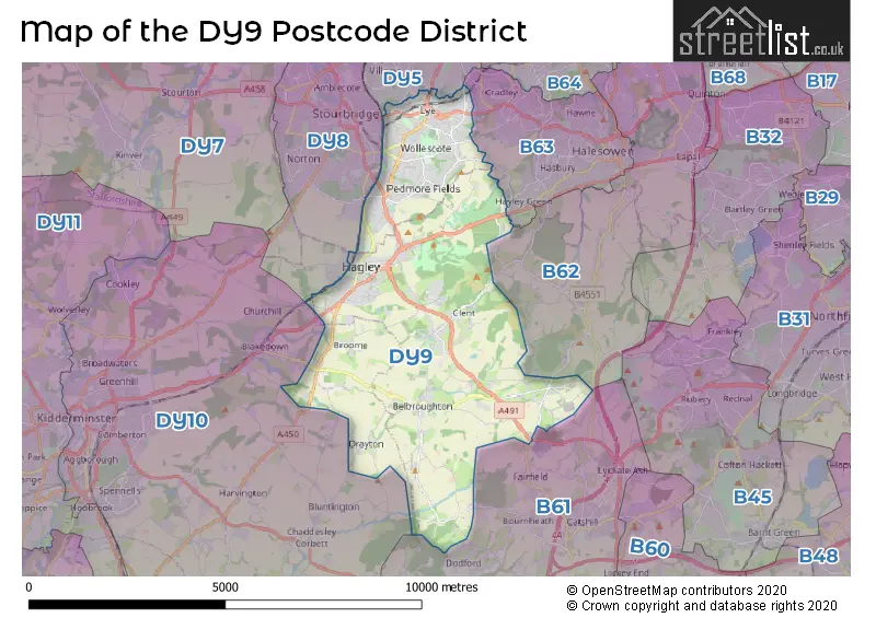
The DY9 Postcode shares a border with B62 (HALESOWEN, Romsley, Hunnington), B63 (HALESOWEN, Hayley Green), DY5 (BRIERLEY HILL, Pensnett, Quarry Bank), DY8 (STOURBRIDGE, Wollaston, Wordsley), DY10 (KIDDERMINSTER, Cookley, Blakedown) and B61 (BROMSGROVE, Catshill, Dodford).
The primary settlement in the DY9 postcode district is Stourbridge. Other significant settlements include Belbroughton, Broome, Clent, Hagley, Lye, and Wollescote. The post town for this postcode is Stourbridge. The counties represented in this postcode district are Worcestershire and West Midlands. The county of Worcestershire is in England, while the county of West Midlands is in the West Midlands region of England.
For the district DY9, we have data on 4 postcode sectors. Here's a breakdown: The sector DY9 0, covers Hagley and Belbroughton in Worcestershire. The sector DY9 0, covers Stourbridge in West Midlands. The sector DY9 7, covers Stourbridge in West Midlands. The sector DY9 8, covers Stourbridge and Lye in West Midlands. The sector DY9 9, covers Stourbridge in West Midlands. The sector DY9 9, covers Belbroughton and Clent and Hagley in Worcestershire.

Map of the DY9 Postcode District
Explore the DY9 postcode district by using our free interactive map.
When it comes to local government, postal geography often disregards political borders. However, for a breakdown in the DY9 District: the district mostly encompasses the Dudley District (B) (504 postcodes), followed by the Bromsgrove District area (310 postcodes), and finally, the Wyre Forest District area (36 postcodes).
Recent House Sales in DY9
| Date | Price | Address |
|---|---|---|
| 20/10/2023 | £100,000 | Ham Lane, Pedmore, Stourbridge, DY9 0UB |
| 29/09/2023 | £525,000 | Old Grove Gardens, Stourbridge, DY9 0US |
| 21/09/2023 | £330,000 | Dyas Close, Hagley, Stourbridge, DY9 0WH |
| 18/09/2023 | £180,000 | Green Lane, Stourbridge, DY9 7EW |
| 15/09/2023 | £360,000 | Kidderminster Road, Hagley, Stourbridge, DY9 0QL |
| 08/09/2023 | £190,000 | Worcester Road, Hagley, Stourbridge, DY9 0HQ |
| 08/09/2023 | £73,500 | Carlton Avenue, Stourbridge, DY9 9EF |
| 08/09/2023 | £825,000 | South Road, Hagley, Stourbridge, DY9 0JT |
| 01/09/2023 | £350,000 | Milestone Drive, Hagley, Stourbridge, DY9 0LP |
| 31/08/2023 | £975,000 | High Street, Belbroughton, Stourbridge, DY9 9ST |
Where is the DY9 Postcode District?
The postcode district for DY9 is located in the town of Stourbridge. Stourbridge is situated near several other towns, including Halesowen to the North East (3.46 miles away), Brierley Hill to the North (5.16 miles away), Bromsgrove to the South East (5.99 miles away), and Kidderminster to the West (6.28 miles away). In addition, the distance from Stourbridge to the centre of London is approximately 105.36 miles.
The district is within the post town of STOURBRIDGE.
The sector has postcodes within the nation of England.
The DY9 Postcode District is covers the following regions.
- Worcestershire - Herefordshire, Worcestershire and Warwickshire - West Midlands (England)
- Dudley - West Midlands - West Midlands (England)
Weather Forecast for DY9
Press Button to Show Forecast for Hagley
| Time Period | Icon | Description | Temperature | Rain Probability | Wind |
|---|---|---|---|---|---|
| 21:00 to 00:00 | Overcast | 11.0°C (feels like 9.0°C) | 13.00% | WSW 7 mph |
Press Button to Show Forecast for Hagley
| Time Period | Icon | Description | Temperature | Rain Probability | Wind |
|---|---|---|---|---|---|
| 00:00 to 03:00 | Cloudy | 9.0°C (feels like 8.0°C) | 10.00% | SW 7 mph | |
| 03:00 to 06:00 | Partly cloudy (night) | 8.0°C (feels like 6.0°C) | 6.00% | SSW 7 mph | |
| 06:00 to 09:00 | Partly cloudy (day) | 8.0°C (feels like 7.0°C) | 3.00% | SSW 7 mph | |
| 09:00 to 12:00 | Partly cloudy (day) | 11.0°C (feels like 10.0°C) | 4.00% | SSW 7 mph | |
| 12:00 to 15:00 | Partly cloudy (day) | 14.0°C (feels like 13.0°C) | 9.00% | S 9 mph | |
| 15:00 to 18:00 | Cloudy | 15.0°C (feels like 14.0°C) | 14.00% | S 9 mph | |
| 18:00 to 21:00 | Partly cloudy (day) | 14.0°C (feels like 13.0°C) | 11.00% | S 9 mph | |
| 21:00 to 00:00 | Cloudy | 12.0°C (feels like 10.0°C) | 10.00% | S 7 mph |
Press Button to Show Forecast for Hagley
| Time Period | Icon | Description | Temperature | Rain Probability | Wind |
|---|---|---|---|---|---|
| 00:00 to 03:00 | Cloudy | 10.0°C (feels like 9.0°C) | 11.00% | S 7 mph | |
| 03:00 to 06:00 | Cloudy | 9.0°C (feels like 8.0°C) | 17.00% | S 7 mph | |
| 06:00 to 09:00 | Partly cloudy (day) | 10.0°C (feels like 8.0°C) | 6.00% | S 7 mph | |
| 09:00 to 12:00 | Cloudy | 12.0°C (feels like 11.0°C) | 9.00% | S 9 mph | |
| 12:00 to 15:00 | Cloudy | 15.0°C (feels like 13.0°C) | 11.00% | S 9 mph | |
| 15:00 to 18:00 | Cloudy | 16.0°C (feels like 14.0°C) | 16.00% | S 9 mph | |
| 18:00 to 21:00 | Cloudy | 15.0°C (feels like 14.0°C) | 14.00% | S 9 mph | |
| 21:00 to 00:00 | Cloudy | 13.0°C (feels like 11.0°C) | 11.00% | SSW 7 mph |
| Postcode Sector | Delivery Office |
|---|---|
| DY9 0 | Stourbridge Delivery Office |
| DY9 7 | Stourbridge Delivery Office |
| DY9 8 | Stourbridge Delivery Office |
| DY9 9 | Stourbridge Delivery Office |
| D | Y | 9 | - | X | X | X |
| D | Y | 9 | Space | Numeric | Letter | Letter |
Tourist Attractions within the DY9 Postcode Area
We found 1 visitor attractions within the DY9 postcode area
| Clent Hills |
|---|
| Historic Properties |
| Historic House / House and Garden / Palace |
| View Clent Hills on Google Maps |
Current Monthly Rental Prices
| # Bedrooms | Min Price | Max Price | Avg Price |
|---|---|---|---|
| 1 | £475 | £650 | £563 |
| 2 | £675 | £825 | £750 |
| 3 | £825 | £1,900 | £1,243 |
Current House Prices
| # Bedrooms | Min Price | Max Price | Avg Price |
|---|---|---|---|
| £25,000 | £1,150,000 | £587,500 | |
| 1 | £77,000 | £245,000 | £130,862 |
| 2 | £120,000 | £550,000 | £240,626 |
| 3 | £150,000 | £1,400,000 | £383,936 |
| 4 | £190,000 | £2,250,000 | £642,776 |
| 5 | £250,000 | £1,800,000 | £850,525 |
| 6 | £2,850,000 | £2,850,000 | £2,850,000 |
| 7 | £1,050,000 | £1,500,000 | £1,275,000 |
Estate Agents who Operate in the DY9 District
| Logo | Name | Brand Name | Address | Contact Number | Total Properties |
|---|---|---|---|---|---|
 | Hagley | Lex Allan Grove | 129 Worcester Road, Hagley, DY9 0NN | 01562 543227 | 30 |
 | Hagley | Walton & Hipkiss | 111 Worcester Road, Hagley, DY9 0NG | 01562 543908 | 17 |
 | Hagley | Shipways | 123 Worcester Road, Hagley, DY9 0NG | 01562 543966 | 16 |
 | Stourbridge | Lex Allan | The Auction House, 87/88 St. Johns Road, Stourbridge, DY8 1EH | 01384 437225 | 13 |
 | Stourbridge | Taylors Estate Agents | 85 High Street, Stourbridge, DY8 1ED | 01384 437336 | 12 |
Yearly House Price Averages for the DY9 Postcode District
| Type of Property | 2018 Average | 2018 Sales | 2017 Average | 2017 Sales | 2016 Average | 2016 Sales | 2015 Average | 2015 Sales |
|---|---|---|---|---|---|---|---|---|
| Detached | £454,017 | 198 | £433,487 | 199 | £423,093 | 234 | £416,879 | 180 |
| Semi-Detached | £224,126 | 201 | £204,579 | 172 | £217,507 | 171 | £182,277 | 160 |
| Terraced | £178,769 | 109 | £164,078 | 86 | £174,440 | 105 | £159,613 | 71 |
| Flats | £191,063 | 41 | £169,978 | 71 | £196,763 | 82 | £153,392 | 39 |