The B70 6 postcode sector is within the county of West Midlands.
Did you know? According to the 2021 Census, the B70 6 postcode sector is home to a bustling 7,672 residents!
Given that each sector allows for 400 unique postcode combinations. Letters C, I, K, M, O and V are not allowed in the last two letters of a postcode. With 161 postcodes already in use, this leaves 239 units available.
The B70 6 postal code covers the settlement of WEST BROMWICH.
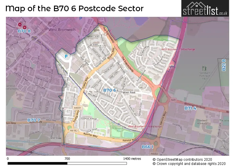
The B70 6 Postcode shares a border with B70 7 (WEST BROMWICH, Lyng), B66 1 (SMETHWICK) and B71 4 (WEST BROMWICH, Sandwell).
The sector is within the post town of WEST BROMWICH.
B70 6 is a postcode sector within the B7 postcode district which is within the B Birmingham postcode area.
The Royal Mail delivery office for the B70 6 postal sector is the unknown.
The area of the B70 6 postcode sector is 0.57 square miles which is 1.48 square kilometres or 366.06 square acres.
The B70 6 postcode sector is crossed by the M5 motorway.
Waterways within the B70 6 postcode sector include the Birmingham Canal.

Map of the B70 6 Postcode Sector
Explore the B70 6 postcode sector by using our free interactive map.
| B | 7 | 0 | - | 6 | X | X |
| B | 7 | 0 | Space | 6 | Letter | Letter |
Official List of Streets
WEST BROMWICH (81 Streets)
Unofficial Streets or Alternative Spellings
SMETHWICK,
SPON LANE SOUTHWEST BROMWICH
BACHE STREET BELL STREET GRICE STREET KELVIN WAY SAMS LANE WATTON STREET ALLEN DRIVE BULL STREET FORE DRAFT SAINT BENEDICTS CLOSE SAINT CHRISTOPHER CLOSE SAINT ELEANOR CLOSE SAINT JAMES CLOSE SAINT VALENTINES CLOSE ST ELEANOR CLOSE THE EXPRESSWAY WATER STREET WEST BROMWICH INTERCHANGE WEST BROMWICH PARKWAYWeather Forecast for B70 6
Press Button to Show Forecast for West Bromwich
| Time Period | Icon | Description | Temperature | Rain Probability | Wind |
|---|---|---|---|---|---|
| 03:00 to 06:00 | Cloudy | 11.0°C (feels like 10.0°C) | 4.00% | ESE 4 mph | |
| 06:00 to 09:00 | Cloudy | 11.0°C (feels like 10.0°C) | 5.00% | SE 4 mph | |
| 09:00 to 12:00 | Cloudy | 13.0°C (feels like 12.0°C) | 4.00% | ESE 4 mph | |
| 12:00 to 15:00 | Cloudy | 15.0°C (feels like 14.0°C) | 23.00% | E 7 mph | |
| 15:00 to 18:00 | Cloudy | 16.0°C (feels like 14.0°C) | 57.00% | NE 7 mph | |
| 18:00 to 21:00 | Light rain | 15.0°C (feels like 13.0°C) | 52.00% | NNE 9 mph | |
| 21:00 to 00:00 | Cloudy | 13.0°C (feels like 12.0°C) | 8.00% | NNE 9 mph |
Press Button to Show Forecast for West Bromwich
| Time Period | Icon | Description | Temperature | Rain Probability | Wind |
|---|---|---|---|---|---|
| 00:00 to 03:00 | Overcast | 11.0°C (feels like 9.0°C) | 11.00% | NNE 11 mph | |
| 03:00 to 06:00 | Overcast | 10.0°C (feels like 8.0°C) | 18.00% | NE 9 mph | |
| 06:00 to 09:00 | Overcast | 10.0°C (feels like 7.0°C) | 18.00% | NNE 11 mph | |
| 09:00 to 12:00 | Cloudy | 12.0°C (feels like 10.0°C) | 5.00% | NE 11 mph | |
| 12:00 to 15:00 | Overcast | 16.0°C (feels like 14.0°C) | 8.00% | NE 11 mph | |
| 15:00 to 18:00 | Cloudy | 18.0°C (feels like 16.0°C) | 7.00% | NE 11 mph | |
| 18:00 to 21:00 | Cloudy | 16.0°C (feels like 15.0°C) | 9.00% | NE 9 mph | |
| 21:00 to 00:00 | Cloudy | 13.0°C (feels like 12.0°C) | 7.00% | NNE 9 mph |
Press Button to Show Forecast for West Bromwich
| Time Period | Icon | Description | Temperature | Rain Probability | Wind |
|---|---|---|---|---|---|
| 00:00 to 03:00 | Overcast | 11.0°C (feels like 9.0°C) | 11.00% | NNE 7 mph | |
| 03:00 to 06:00 | Overcast | 10.0°C (feels like 9.0°C) | 13.00% | N 4 mph | |
| 06:00 to 09:00 | Overcast | 10.0°C (feels like 9.0°C) | 14.00% | NNW 7 mph | |
| 09:00 to 12:00 | Overcast | 11.0°C (feels like 10.0°C) | 15.00% | NW 7 mph | |
| 12:00 to 15:00 | Overcast | 14.0°C (feels like 12.0°C) | 15.00% | NW 9 mph | |
| 15:00 to 18:00 | Cloudy | 15.0°C (feels like 13.0°C) | 13.00% | WNW 9 mph | |
| 18:00 to 21:00 | Cloudy | 14.0°C (feels like 12.0°C) | 15.00% | WNW 9 mph | |
| 21:00 to 00:00 | Cloudy | 12.0°C (feels like 10.0°C) | 11.00% | W 9 mph |
Press Button to Show Forecast for West Bromwich
| Time Period | Icon | Description | Temperature | Rain Probability | Wind |
|---|---|---|---|---|---|
| 00:00 to 03:00 | Cloudy | 10.0°C (feels like 8.0°C) | 9.00% | W 7 mph | |
| 03:00 to 06:00 | Partly cloudy (night) | 9.0°C (feels like 7.0°C) | 7.00% | W 7 mph | |
| 06:00 to 09:00 | Cloudy | 9.0°C (feels like 7.0°C) | 9.00% | WSW 7 mph | |
| 09:00 to 12:00 | Cloudy | 11.0°C (feels like 10.0°C) | 8.00% | WSW 7 mph | |
| 12:00 to 15:00 | Cloudy | 14.0°C (feels like 13.0°C) | 10.00% | WSW 9 mph | |
| 15:00 to 18:00 | Cloudy | 16.0°C (feels like 14.0°C) | 9.00% | SSW 9 mph | |
| 18:00 to 21:00 | Cloudy | 15.0°C (feels like 13.0°C) | 10.00% | SW 9 mph | |
| 21:00 to 00:00 | Cloudy | 13.0°C (feels like 11.0°C) | 13.00% | SSW 9 mph |
Schools and Places of Education Within the B70 6 Postcode Sector
Holy Trinity CofE Primary School
Voluntary controlled school
Trinity Road South, West Bromwich, West Midlands, B70 6NF
Head: Mrs Joanne Corbett
Ofsted Rating: Good
Inspection: 2023-04-20 (377 days ago)
Website: Visit Holy Trinity CofE Primary School Website
Phone: 01215531573
Number of Pupils: 461
King George V Primary School
Community school
Beeches Road, West Bromwich, West Midlands, B70 6JA
Head: Miss Sarah Penny
Ofsted Rating: Good
Inspection: 2019-05-16 (1812 days ago)
Website: Visit King George V Primary School Website
Phone: 01215530060
Number of Pupils: 226
Sandwell College
Further education
1 Spon Lane, West Bromwich, West Midlands, B70 6AW
Head: Mr Graham Pennington
Ofsted Rating: Good
Inspection: 2022-10-14 (565 days ago)
Website: Visit Sandwell College Website
Phone: 01216675000
Number of Pupils: 0
Sandwell Valley School
Other independent school
150 Birmingham Road, West Bromwich, , B70 6QT
Head: Principal Mim Hall
Ofsted Rating: Outstanding
Inspection: 2022-06-16 (685 days ago)
Website: Visit Sandwell Valley School Website
Phone: 01216797522
Number of Pupils: 79
House Prices in the B70 6 Postcode Sector
| Type of Property | 2018 Average | 2018 Sales | 2017 Average | 2017 Sales | 2016 Average | 2016 Sales | 2015 Average | 2015 Sales |
|---|---|---|---|---|---|---|---|---|
| Detached | £205,903 | 11 | £221,456 | 9 | £205,887 | 18 | £186,804 | 23 |
| Semi-Detached | £143,714 | 7 | £137,602 | 9 | £140,069 | 16 | £174,700 | 25 |
| Terraced | £149,548 | 28 | £129,820 | 25 | £119,806 | 25 | £119,556 | 36 |
| Flats | £80,167 | 3 | £84,000 | 2 | £74,250 | 2 | £70,000 | 4 |
Important Postcodes B70 6 in the Postcode Sector
B70 6AW is the postcode for Sandwell College, 1 Spon Lane
B70 6HQ is the postcode for West Bromwich Childrens Centre, 160 Beeches Road
B70 6JA is the postcode for King George V Primary School, Beeches Road
B70 6JX is the postcode for Doctors Surgery, 6 High Street
B70 6NF is the postcode for NEW CLASSROOM BLOCK, Holy Trinity Primary School, Trinity Road South, Holy Trinity Primary School, Trinity Road South, and HOLY TRINITY PRIMARY SCHOOL, TRINITY ROAD SOUTH, WEST BROMWICH
B70 6QG is the postcode for Accord Housing Association Ltd, 178 Birmingham Road
B70 6RP is the postcode for Interserve F M, Intersection House, 110-120 Birmingham Road
B70 6ZY is the postcode for Sandwell M B C, Lodge Road
| The B70 6 Sector is within these Local Authorities |
|
|---|---|
| The B70 6 Sector is within these Counties |
|
| The B70 6 Sector is within these Water Company Areas |
|