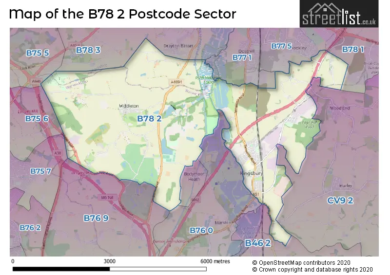
The B78 2 postcode sector lies where the three counties of Warwickshire, West Midlands, and Staffordshire meet.
Did you know? According to the 2021 Census, the B78 2 postcode sector is home to a bustling 4,562 residents!
Given that each sector allows for 400 unique postcode combinations. Letters C, I, K, M, O and V are not allowed in the last two letters of a postcode. With 141 postcodes already in use, this leaves 259 units available.
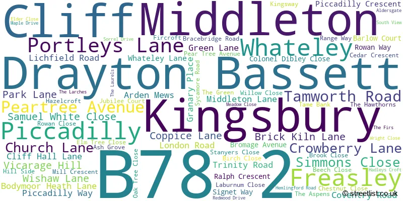
The largest settlement in the B78 2 postal code is Kingsbury followed by Middleton, and Piccadilly.
The B78 2 Postcode shares a border with B46 2 (Coleshill, Furnace End), B76 0 (Lea Marston, Marston, Curdworth), B76 9 (Minworth, Curdworth, Wishaw), B77 1 (TAMWORTH, Dosthill, Two Gates), CV9 2 (Grendon, ATHERSTONE, Hurley), B75 5 (SUTTON COLDFIELD, Canwell, Bassetts Pole), B75 6 (SUTTON COLDFIELD, Bassetts Pole), B75 7 (SUTTON COLDFIELD), B77 5 (Wilnecote, Hockley, TAMWORTH), B78 1 (Polesworth, Dordon, Birchmoor) and B78 3 (TAMWORTH, Fazeley, Mile Oak).
The sector is within the post town of TAMWORTH.
B78 2 is a postcode sector within the B7 postcode district which is within the B Birmingham postcode area.
The Royal Mail delivery office for the B78 2 postal sector is the unknown.
The area of the B78 2 postcode sector is 10.62 square miles which is 27.49 square kilometres or 6,793.76 square acres.
The B78 2 postcode sector is crossed by the M42 motorway.
Waterways within the B78 2 postcode sector include the River Tame, Collets Brook, Langley Brook, Birmingham and Fazeley Canal.

Map of the B78 2 Postcode Sector
Explore the B78 2 postcode sector by using our free interactive map.
| B | 7 | 8 | - | 2 | X | X |
| B | 7 | 8 | Space | 2 | Letter | Letter |
Official List of Streets
Kingsbury (50 Streets)
Middleton (15 Streets)
Piccadilly (3 Streets)
Drayton Bassett (1 Streets)
Freasley (2 Streets)
Whateley (1 Streets)
Unofficial Streets or Alternative Spellings
Hockley
OVERWOODS ROAD WHATELEY LANEDosthill
RUSH LANEBodymoor Heath
BODYMOOR HEATH LANEWishaw
CUTTLE MILL LANECurdworth
LICHFIELD ROADDrayton Bassett
DRAYTON LANEBassetts Pole
LONDON ROADCastle Vale
KINGSBURY ROADWeather Forecast for B78 2
Press Button to Show Forecast for The Belfry Golf Club
| Time Period | Icon | Description | Temperature | Rain Probability | Wind |
|---|---|---|---|---|---|
| 12:00 to 15:00 | Cloudy | 16.0°C (feels like 15.0°C) | 13.00% | E 4 mph | |
| 15:00 to 18:00 | Overcast | 16.0°C (feels like 15.0°C) | 12.00% | NE 7 mph | |
| 18:00 to 21:00 | Cloudy | 15.0°C (feels like 14.0°C) | 9.00% | NNE 9 mph | |
| 21:00 to 00:00 | Cloudy | 14.0°C (feels like 12.0°C) | 6.00% | NNE 9 mph |
Press Button to Show Forecast for The Belfry Golf Club
| Time Period | Icon | Description | Temperature | Rain Probability | Wind |
|---|---|---|---|---|---|
| 00:00 to 03:00 | Overcast | 11.0°C (feels like 9.0°C) | 10.00% | NNE 11 mph | |
| 03:00 to 06:00 | Overcast | 10.0°C (feels like 8.0°C) | 18.00% | NE 9 mph | |
| 06:00 to 09:00 | Overcast | 10.0°C (feels like 8.0°C) | 18.00% | NNE 11 mph | |
| 09:00 to 12:00 | Cloudy | 13.0°C (feels like 11.0°C) | 11.00% | NE 13 mph | |
| 12:00 to 15:00 | Overcast | 17.0°C (feels like 15.0°C) | 8.00% | NE 11 mph | |
| 15:00 to 18:00 | Cloudy | 19.0°C (feels like 17.0°C) | 6.00% | NE 11 mph | |
| 18:00 to 21:00 | Cloudy | 17.0°C (feels like 15.0°C) | 6.00% | ENE 9 mph | |
| 21:00 to 00:00 | Cloudy | 13.0°C (feels like 12.0°C) | 6.00% | NE 9 mph |
Press Button to Show Forecast for The Belfry Golf Club
| Time Period | Icon | Description | Temperature | Rain Probability | Wind |
|---|---|---|---|---|---|
| 00:00 to 03:00 | Overcast | 11.0°C (feels like 10.0°C) | 10.00% | NE 7 mph | |
| 03:00 to 06:00 | Overcast | 11.0°C (feels like 9.0°C) | 13.00% | N 4 mph | |
| 06:00 to 09:00 | Overcast | 11.0°C (feels like 10.0°C) | 15.00% | NNW 4 mph | |
| 09:00 to 12:00 | Overcast | 12.0°C (feels like 11.0°C) | 13.00% | NW 7 mph | |
| 12:00 to 15:00 | Overcast | 15.0°C (feels like 13.0°C) | 15.00% | WNW 9 mph | |
| 15:00 to 18:00 | Cloudy | 16.0°C (feels like 14.0°C) | 13.00% | WNW 9 mph | |
| 18:00 to 21:00 | Light rain shower (day) | 15.0°C (feels like 13.0°C) | 35.00% | WNW 9 mph | |
| 21:00 to 00:00 | Cloudy | 12.0°C (feels like 11.0°C) | 11.00% | WNW 9 mph |
Press Button to Show Forecast for The Belfry Golf Club
| Time Period | Icon | Description | Temperature | Rain Probability | Wind |
|---|---|---|---|---|---|
| 00:00 to 03:00 | Clear night | 11.0°C (feels like 9.0°C) | 6.00% | W 7 mph | |
| 03:00 to 06:00 | Partly cloudy (night) | 9.0°C (feels like 8.0°C) | 6.00% | W 7 mph | |
| 06:00 to 09:00 | Partly cloudy (day) | 9.0°C (feels like 8.0°C) | 7.00% | WSW 7 mph | |
| 09:00 to 12:00 | Cloudy | 12.0°C (feels like 11.0°C) | 9.00% | WSW 7 mph | |
| 12:00 to 15:00 | Cloudy | 15.0°C (feels like 14.0°C) | 10.00% | SW 7 mph | |
| 15:00 to 18:00 | Cloudy | 16.0°C (feels like 15.0°C) | 11.00% | SSW 9 mph | |
| 18:00 to 21:00 | Cloudy | 15.0°C (feels like 14.0°C) | 12.00% | W 9 mph | |
| 21:00 to 00:00 | Partly cloudy (night) | 13.0°C (feels like 12.0°C) | 5.00% | W 7 mph |
Schools and Places of Education Within the B78 2 Postcode Sector
Kingsbury Primary School
Community school
Bromage Avenue, Tamworth, Staffordshire, B78 2HW
Head: Mrs K Hanson
Ofsted Rating: Requires improvement
Inspection: 2023-06-21 (315 days ago)
Website: Visit Kingsbury Primary School Website
Phone: 01827872275
Number of Pupils: 256
Kingsbury School - A Specialist Science and Mathematics Academy
Academy sponsor led
Tamworth Road, Kingsbury, Staffordshire, B78 2LF
Head: Mr Martin Clarke
Ofsted Rating: Good
Inspection: 2023-10-04 (210 days ago)
Website: Visit Kingsbury School - A Specialist Science and Mathematics Academy Website
Phone: 01827872316
Number of Pupils: 705
House Prices in the B78 2 Postcode Sector
| Type of Property | 2018 Average | 2018 Sales | 2017 Average | 2017 Sales | 2016 Average | 2016 Sales | 2015 Average | 2015 Sales |
|---|---|---|---|---|---|---|---|---|
| Detached | £327,714 | 21 | £337,938 | 25 | £251,974 | 21 | £250,619 | 21 |
| Semi-Detached | £215,490 | 39 | £179,578 | 18 | £170,058 | 16 | £166,426 | 21 |
| Terraced | £149,676 | 17 | £152,942 | 26 | £169,872 | 18 | £198,600 | 10 |
| Flats | £106,000 | 1 | £133,917 | 3 | £141,000 | 1 | £96,667 | 3 |
Important Postcodes B78 2 in the Postcode Sector
B78 2HW is the postcode for Kingsbury Primary School, Bromage Avenue, Kingsbury, KINGSBURY COUNTY PRIMARY SCHOOL, BROMAGE AVENUE, KINGSBURY, and Kingsbury Primary School, Bromage Avenue
B78 2LF is the postcode for Kingsbury School, Tamworth Road, TEACHING BLOCK, Kingsbury School, Tamworth Road, HORSA BUILDING, Kingsbury School, Tamworth Road, and MAIN BUILDING, Kingsbury School, Tamworth Road
B78 2LN is the postcode for Kingsbury Youth & Community Centre, Coventry Road
| The B78 2 Sector is within these Local Authorities |
|
|---|---|
| The B78 2 Sector is within these Counties |
|
| The B78 2 Sector is within these Water Company Areas |
|