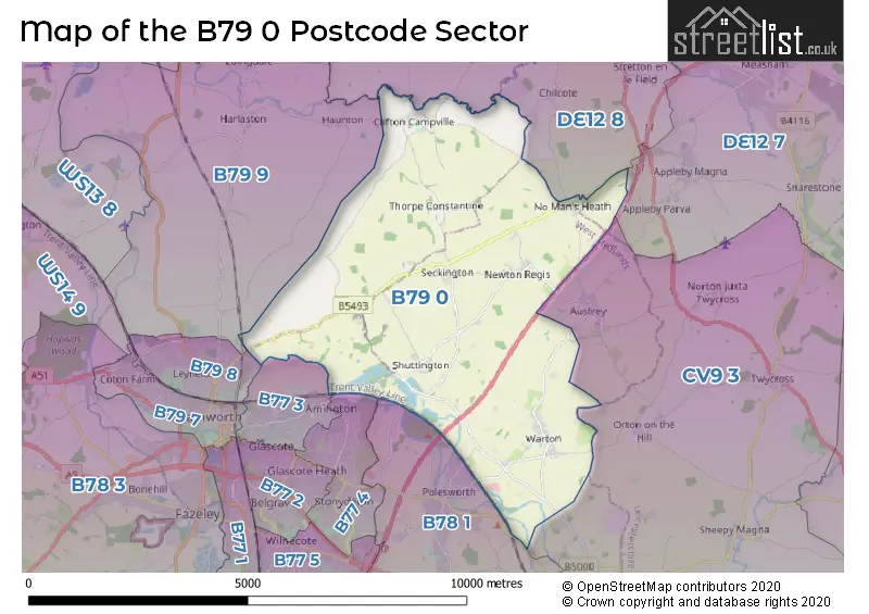
The B79 0 postcode sector lies where the four counties of Leicestershire, Warwickshire, Derbyshire, and Staffordshire meet.
Did you know? According to the 2021 Census, the B79 0 postcode sector is home to a bustling 4,457 residents!
Given that each sector allows for 400 unique postcode combinations. Letters C, I, K, M, O and V are not allowed in the last two letters of a postcode. With 139 postcodes already in use, this leaves 261 units available.
The largest settlement in the B79 0 postal code is TAMWORTH followed by Warton, and Clifton Campville.
The B79 0 Postcode shares a border with B79 9 (Elford, Edingale, Wigginton), CV9 3 (ATHERSTONE, Austrey, Sheepy Magna), DE12 7 (Measham, Donisthorpe, Appleby Magna), DE12 8 (Netherseal, Walton-on-Trent, Coton-in-the-Elms), B77 3 (TAMWORTH, Amington, Bolehall), B77 4 (Wilnecote, TAMWORTH, Amington), B78 1 (Polesworth, Dordon, Birchmoor) and B79 8 (TAMWORTH).
The sector is within the post town of TAMWORTH.
B79 0 is a postcode sector within the B7 postcode district which is within the B Birmingham postcode area.
The Royal Mail delivery office for the B79 0 postal sector is the unknown.
The area of the B79 0 postcode sector is 17.71 square miles which is 45.86 square kilometres or 11,331.26 square acres.
The B79 0 postcode sector is crossed by the M42 motorway.
Waterways within the B79 0 postcode sector include the Coventry Canal.

Map of the B79 0 Postcode Sector
Explore the B79 0 postcode sector by using our free interactive map.
| B | 7 | 9 | - | 0 | X | X |
| B | 7 | 9 | Space | 0 | Letter | Letter |
Official List of Streets
Alvecote (2 Streets)
TAMWORTH (24 Streets)
No Mans Heath (5 Streets)
Newton Regis (13 Streets)
Seckington (4 Streets)
Warton (27 Streets)
Clifton Campville (11 Streets)
Shuttington (7 Streets)
Thorpe Constantine (1 Streets)
Polesworth (1 Streets)
Unofficial Streets or Alternative Spellings
Austrey
NEWTON LANE WARTON LANEChilcote
QUARRY BERRY LANEWeather Forecast for B79 0
Press Button to Show Forecast for Orton-On-The-Hill
| Time Period | Icon | Description | Temperature | Rain Probability | Wind |
|---|---|---|---|---|---|
| 09:00 to 12:00 | Cloudy | 14.0°C (feels like 13.0°C) | 6.00% | E 4 mph | |
| 12:00 to 15:00 | Cloudy | 15.0°C (feels like 15.0°C) | 14.00% | ENE 7 mph | |
| 15:00 to 18:00 | Cloudy | 16.0°C (feels like 14.0°C) | 19.00% | NE 9 mph | |
| 18:00 to 21:00 | Cloudy | 15.0°C (feels like 14.0°C) | 13.00% | NNE 9 mph | |
| 21:00 to 00:00 | Cloudy | 13.0°C (feels like 11.0°C) | 9.00% | NNE 9 mph |
Press Button to Show Forecast for Orton-On-The-Hill
| Time Period | Icon | Description | Temperature | Rain Probability | Wind |
|---|---|---|---|---|---|
| 00:00 to 03:00 | Overcast | 11.0°C (feels like 8.0°C) | 10.00% | NNE 11 mph | |
| 03:00 to 06:00 | Overcast | 10.0°C (feels like 8.0°C) | 15.00% | NE 11 mph | |
| 06:00 to 09:00 | Overcast | 10.0°C (feels like 8.0°C) | 9.00% | NNE 13 mph | |
| 09:00 to 12:00 | Cloudy | 13.0°C (feels like 11.0°C) | 5.00% | NE 13 mph | |
| 12:00 to 15:00 | Cloudy | 17.0°C (feels like 15.0°C) | 4.00% | NE 13 mph | |
| 15:00 to 18:00 | Partly cloudy (day) | 18.0°C (feels like 16.0°C) | 3.00% | NE 13 mph | |
| 18:00 to 21:00 | Partly cloudy (day) | 16.0°C (feels like 14.0°C) | 2.00% | NE 11 mph | |
| 21:00 to 00:00 | Cloudy | 12.0°C (feels like 10.0°C) | 6.00% | NE 9 mph |
Press Button to Show Forecast for Orton-On-The-Hill
| Time Period | Icon | Description | Temperature | Rain Probability | Wind |
|---|---|---|---|---|---|
| 00:00 to 03:00 | Overcast | 11.0°C (feels like 9.0°C) | 10.00% | NNE 7 mph | |
| 03:00 to 06:00 | Overcast | 10.0°C (feels like 9.0°C) | 15.00% | N 7 mph | |
| 06:00 to 09:00 | Overcast | 10.0°C (feels like 9.0°C) | 17.00% | NW 7 mph | |
| 09:00 to 12:00 | Overcast | 12.0°C (feels like 11.0°C) | 18.00% | WNW 7 mph | |
| 12:00 to 15:00 | Overcast | 14.0°C (feels like 13.0°C) | 17.00% | WNW 9 mph | |
| 15:00 to 18:00 | Cloudy | 15.0°C (feels like 14.0°C) | 16.00% | WNW 9 mph | |
| 18:00 to 21:00 | Cloudy | 14.0°C (feels like 13.0°C) | 15.00% | W 9 mph | |
| 21:00 to 00:00 | Cloudy | 12.0°C (feels like 11.0°C) | 11.00% | W 9 mph |
Press Button to Show Forecast for Orton-On-The-Hill
| Time Period | Icon | Description | Temperature | Rain Probability | Wind |
|---|---|---|---|---|---|
| 00:00 to 03:00 | Cloudy | 11.0°C (feels like 9.0°C) | 9.00% | W 7 mph | |
| 03:00 to 06:00 | Cloudy | 9.0°C (feels like 8.0°C) | 11.00% | W 7 mph | |
| 06:00 to 09:00 | Cloudy | 10.0°C (feels like 8.0°C) | 11.00% | WSW 7 mph | |
| 09:00 to 12:00 | Cloudy | 12.0°C (feels like 11.0°C) | 9.00% | WSW 7 mph | |
| 12:00 to 15:00 | Cloudy | 15.0°C (feels like 14.0°C) | 12.00% | WSW 7 mph | |
| 15:00 to 18:00 | Cloudy | 16.0°C (feels like 15.0°C) | 11.00% | SW 9 mph | |
| 18:00 to 21:00 | Cloudy | 15.0°C (feels like 14.0°C) | 10.00% | SW 7 mph | |
| 21:00 to 00:00 | Partly cloudy (night) | 12.0°C (feels like 11.0°C) | 5.00% | SW 7 mph |
Schools and Places of Education Within the B79 0 Postcode Sector
Anker Valley Primary Academy
Free schools
Brooklime Way, Tamworth, Staffordshire, B79 0FD
Head: Mrs Natalie Horlor
Ofsted Rating: Good
Inspection: 2024-01-24 (98 days ago)
Website: Visit Anker Valley Primary Academy Website
Phone: 01827949310
Number of Pupils: 53
Newton Regis CofE Primary School
Academy converter
Austrey Lane, Tamworth, Staffordshire, B79 0NL
Head: Mrs Sara Eley
Ofsted Rating: Good
Inspection: 2019-07-03 (1764 days ago)
Website: Visit Newton Regis CofE Primary School Website
Phone: 01827830220
Number of Pupils: 96
Warton Nethersole's CofE Primary School
Academy converter
Maypole Road, Tamworth, Staffordshire, B79 0HP
Head: Miss Susan Friend
Ofsted Rating: Good
Inspection: 2019-04-03 (1855 days ago)
Website: Visit Warton Nethersole's CofE Primary School Website
Phone: 01827894182
Number of Pupils: 142
House Prices in the B79 0 Postcode Sector
| Type of Property | 2018 Average | 2018 Sales | 2017 Average | 2017 Sales | 2016 Average | 2016 Sales | 2015 Average | 2015 Sales |
|---|---|---|---|---|---|---|---|---|
| Detached | £362,642 | 77 | £337,230 | 26 | £383,361 | 22 | £335,693 | 27 |
| Semi-Detached | £253,463 | 40 | £223,722 | 22 | £199,930 | 15 | £161,544 | 23 |
| Terraced | £197,358 | 21 | £178,150 | 11 | £166,163 | 12 | £144,875 | 8 |
| Flats | £335,000 | 1 | £0 | 0 | £0 | 0 | £0 | 0 |
Important Postcodes B79 0 in the Postcode Sector
B79 0FD is the postcode for Anker Valley Primary Academy, Brooklime Way
B79 0NL is the postcode for Newton Regis C of E Primary School, Austrey Lane, Newton Regis
| The B79 0 Sector is within these Local Authorities |
|
|---|---|
| The B79 0 Sector is within these Counties |
|
| The B79 0 Sector is within these Water Company Areas |
|