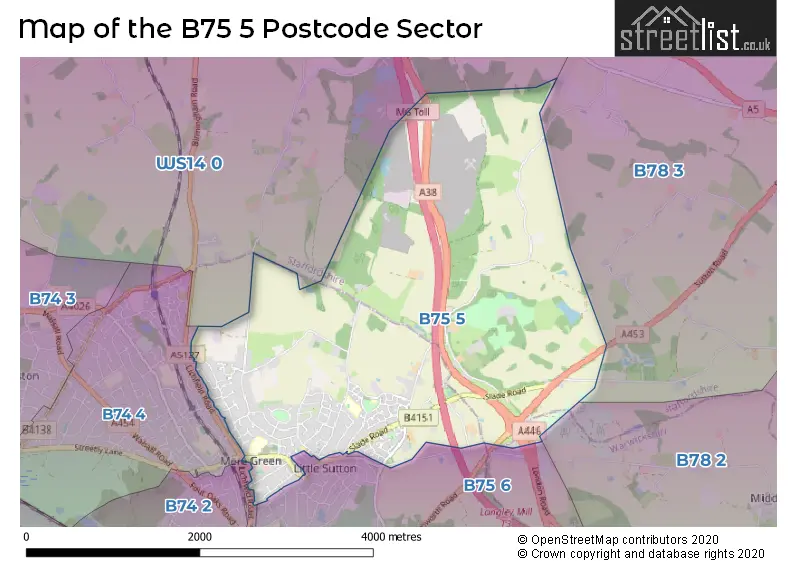
The B75 5 postcode sector lies where the three counties of Staffordshire, West Midlands, and Warwickshire meet.
Did you know? According to the 2021 Census, the B75 5 postcode sector is home to a bustling 8,703 residents!
Given that each sector allows for 400 unique postcode combinations. Letters C, I, K, M, O and V are not allowed in the last two letters of a postcode. With 231 postcodes already in use, this leaves 169 units available.
The largest settlement in the B75 5 postal code is SUTTON COLDFIELD followed by Canwell, and Bassetts Pole.
The B75 5 Postcode shares a border with WS14 0 (LICHFIELD, Shenstone, Weeford), B74 2 (SUTTON COLDFIELD, Streetly), B74 4 (SUTTON COLDFIELD), B75 6 (SUTTON COLDFIELD, Bassetts Pole), B78 2 (Kingsbury, Middleton, Piccadilly) and B78 3 (TAMWORTH, Fazeley, Mile Oak).
The sector is within the post town of SUTTON COLDFIELD.
B75 5 is a postcode sector within the B75 postcode district which is within the B Birmingham postcode area.
The Royal Mail delivery office for the B75 5 postal sector is the Sutton Coldfield Postal Delivery Office.
The area of the B75 5 postcode sector is 5.20 square miles which is 13.46 square kilometres or 3,325.16 square acres.
The B75 5 postcode sector is crossed by the M6 motorway.

Map of the B75 5 Postcode Sector
Explore the B75 5 postcode sector by using our free interactive map.
| B | 7 | 5 | - | 5 | X | X |
| B | 7 | 5 | Space | 5 | Letter | Letter |
Official List of Streets
SUTTON COLDFIELD (103 Streets)
Canwell (7 Streets)
Bassetts Pole (2 Streets)
Unofficial Streets or Alternative Spellings
Weather Forecast for B75 5
Press Button to Show Forecast for Roughley
| Time Period | Icon | Description | Temperature | Rain Probability | Wind |
|---|---|---|---|---|---|
| 12:00 to 15:00 | Light rain | 7.0°C (feels like 4.0°C) | 58.00% | ENE 11 mph | |
| 15:00 to 18:00 | Overcast | 7.0°C (feels like 4.0°C) | 46.00% | ENE 11 mph | |
| 18:00 to 21:00 | Overcast | 7.0°C (feels like 4.0°C) | 17.00% | NE 11 mph | |
| 21:00 to 00:00 | Overcast | 6.0°C (feels like 3.0°C) | 12.00% | NE 11 mph |
Press Button to Show Forecast for Roughley
| Time Period | Icon | Description | Temperature | Rain Probability | Wind |
|---|---|---|---|---|---|
| 00:00 to 03:00 | Overcast | 5.0°C (feels like 2.0°C) | 12.00% | NNE 11 mph | |
| 03:00 to 06:00 | Overcast | 5.0°C (feels like 1.0°C) | 19.00% | NNE 11 mph | |
| 06:00 to 09:00 | Light rain | 5.0°C (feels like 1.0°C) | 53.00% | N 11 mph | |
| 09:00 to 12:00 | Heavy rain | 6.0°C (feels like 3.0°C) | 71.00% | NNW 11 mph | |
| 12:00 to 15:00 | Light rain | 8.0°C (feels like 5.0°C) | 48.00% | NW 9 mph | |
| 15:00 to 18:00 | Overcast | 9.0°C (feels like 7.0°C) | 17.00% | WNW 9 mph | |
| 18:00 to 21:00 | Cloudy | 9.0°C (feels like 7.0°C) | 10.00% | W 9 mph | |
| 21:00 to 00:00 | Clear night | 7.0°C (feels like 5.0°C) | 3.00% | SW 7 mph |
Press Button to Show Forecast for Roughley
| Time Period | Icon | Description | Temperature | Rain Probability | Wind |
|---|---|---|---|---|---|
| 00:00 to 03:00 | Clear night | 5.0°C (feels like 3.0°C) | 1.00% | SW 7 mph | |
| 03:00 to 06:00 | Clear night | 4.0°C (feels like 1.0°C) | 2.00% | SSW 9 mph | |
| 06:00 to 09:00 | Partly cloudy (day) | 5.0°C (feels like 2.0°C) | 1.00% | S 9 mph | |
| 09:00 to 12:00 | Partly cloudy (day) | 10.0°C (feels like 7.0°C) | 2.00% | S 11 mph | |
| 12:00 to 15:00 | Overcast | 12.0°C (feels like 9.0°C) | 10.00% | S 16 mph | |
| 15:00 to 18:00 | Cloudy | 13.0°C (feels like 10.0°C) | 8.00% | S 16 mph | |
| 18:00 to 21:00 | Cloudy | 12.0°C (feels like 9.0°C) | 7.00% | S 13 mph | |
| 21:00 to 00:00 | Clear night | 9.0°C (feels like 6.0°C) | 3.00% | SSE 11 mph |
Press Button to Show Forecast for Roughley
| Time Period | Icon | Description | Temperature | Rain Probability | Wind |
|---|---|---|---|---|---|
| 00:00 to 03:00 | Clear night | 8.0°C (feels like 5.0°C) | 4.00% | SSE 11 mph | |
| 03:00 to 06:00 | Clear night | 7.0°C (feels like 4.0°C) | 3.00% | SE 11 mph | |
| 06:00 to 09:00 | Sunny day | 7.0°C (feels like 4.0°C) | 4.00% | SE 11 mph | |
| 09:00 to 12:00 | Sunny day | 12.0°C (feels like 9.0°C) | 5.00% | SE 11 mph | |
| 12:00 to 15:00 | Partly cloudy (day) | 14.0°C (feels like 12.0°C) | 12.00% | SE 13 mph | |
| 15:00 to 18:00 | Cloudy | 15.0°C (feels like 12.0°C) | 12.00% | SE 11 mph | |
| 18:00 to 21:00 | Partly cloudy (day) | 14.0°C (feels like 12.0°C) | 10.00% | SE 11 mph | |
| 21:00 to 00:00 | Cloudy | 11.0°C (feels like 10.0°C) | 11.00% | ESE 9 mph |
Schools and Places of Education Within the B75 5 Postcode Sector
Little Sutton Primary School
Foundation school
Worcester Lane, Sutton Coldfield, West Midlands, B75 5NL
Head: Mrs Rachel Davis
Ofsted Rating: Outstanding
Inspection: 2012-09-20 (4237 days ago)
Website: Visit Little Sutton Primary School Website
Phone: 01214644494
Number of Pupils: 422
Mere Green Primary School
Academy converter
Mere Green Road, Sutton Coldfield, West Midlands, B75 5BL
Head: Mrs Kristal Brookes
Ofsted Rating: Outstanding
Inspection: 2015-01-14 (3391 days ago)
Website: Visit Mere Green Primary School Website
Phone: 01213081384
Number of Pupils: 438
House Prices in the B75 5 Postcode Sector
| Type of Property | 2018 Average | 2018 Sales | 2017 Average | 2017 Sales | 2016 Average | 2016 Sales | 2015 Average | 2015 Sales |
|---|---|---|---|---|---|---|---|---|
| Detached | £495,468 | 64 | £439,335 | 55 | £442,061 | 47 | £385,846 | 85 |
| Semi-Detached | £309,446 | 45 | £275,365 | 56 | £271,443 | 57 | £250,632 | 50 |
| Terraced | £244,616 | 32 | £225,707 | 30 | £197,282 | 34 | £210,029 | 33 |
| Flats | £161,467 | 18 | £170,644 | 17 | £162,753 | 15 | £119,833 | 18 |
Important Postcodes B75 5 in the Postcode Sector
B75 5BL is the postcode for JUNIOR BLOCK, Mere Green Combined School, Mere Green Road, Mere Green Combined School, Mere Green Road, and INFANT BLOCK, Mere Green Combined School, Mere Green Road
B75 5BP is the postcode for 6-8, Mere Green Road, and Birmingham City Council, Mere Green Library, Mere Green Road
B75 5BS is the postcode for Four Oaks Medical Centre, Carlton House, 18 Mere Green Road
B75 5BT is the postcode for Birmingham City Council, Mere Green Library & Community Centre, and Birmingham City Council, Mere Green Library & Community Centre, 30A Mere Green Road
B75 5NL is the postcode for Little Sutton Primary School, Worcester Lane
| The B75 5 Sector is within these Local Authorities |
|
|---|---|
| The B75 5 Sector is within these Counties |
|
| The B75 5 Sector is within these Water Company Areas |
|