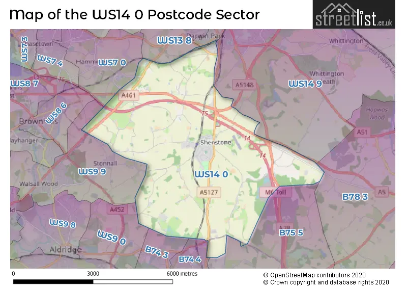
The WS14 0 postcode sector stands on the Staffordshire and West Midlands border.
Did you know? According to the 2021 Census, the WS14 0 postcode sector is home to a bustling 4,561 residents!
Given that each sector allows for 400 unique postcode combinations. Letters C, I, K, M, O and V are not allowed in the last two letters of a postcode. With 186 postcodes already in use, this leaves 214 units available.
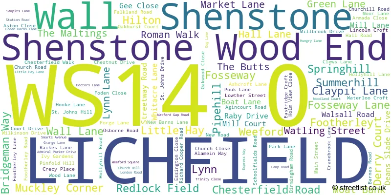
The largest settlement in the WS14 0 postal code is LICHFIELD followed by Shenstone, and Weeford.
The WS14 0 Postcode shares a border with WS7 0 (BURNTWOOD, Hammerwich), WS9 0 (WALSALL, Aldridge), WS14 9 (LICHFIELD, Whittington, Whittington Barracks), WS13 6 (LICHFIELD), WS13 8 (LICHFIELD, Fradley, Streethay), WS9 9 (WALSALL, Walsall Wood, Stonnall), B74 3 (SUTTON COLDFIELD, Streetly, Little Aston), B74 4 (SUTTON COLDFIELD), B75 5 (SUTTON COLDFIELD, Canwell, Bassetts Pole) and B78 3 (TAMWORTH, Fazeley, Mile Oak).
The sector is within the post town of LICHFIELD.
WS14 0 is a postcode sector within the WS14 postcode district which is within the WS Walsall postcode area.
The Royal Mail delivery office for the WS14 0 postal sector is the Lichfield Delivery Office and Shenstone Scale Payment Delivery Office.
The area of the WS14 0 postcode sector is 13.56 square miles which is 35.11 square kilometres or 8,675.69 square acres.
The WS14 0 postcode sector is crossed by the A38 Major A road.
The WS14 0 postcode sector is crossed by the A5 Major A road.
The WS14 0 postcode sector is crossed by the A5148 Major A road.
The WS14 0 postcode sector is crossed by the M6 motorway.
Waterways within the WS14 0 postcode sector include the Black Brook.

Map of the WS14 0 Postcode Sector
Explore the WS14 0 postcode sector by using our free interactive map.
| W | S | 1 | 4 | - | 0 | X | X |
| W | S | 1 | 4 | Space | 0 | Letter | Letter |
Official List of Streets
Shenstone (25 Streets)
LICHFIELD (66 Streets)
Shenstone Wood End (3 Streets)
Weeford (6 Streets)
Footherley (1 Streets)
Wall (3 Streets)
Little Hay (2 Streets)
Muckley Corner (2 Streets)
Pipehill (1 Streets)
Springhill (1 Streets)
Summerhill (1 Streets)
Unofficial Streets or Alternative Spellings
Bassetts Pole
LONDON ROADLICHFIELD,
CAMP ROAD FOOTHERLEY LANESUTTON COLDFIELD
BISHOPS WAY BLAKE STREET HILLWOOD COMMON ROAD LICHFIELD ROAD WYNDLEY CLOSELICHFIELD
FLATS LANE SAINTE FOY AVENUEAldridge
WOOD LANEHammerwich
COPPICE LANE HALL LANEStonnall
MILL LANEWALSALL
CARTERSFIELD LANEBrownhills
BARRACKS LANE WATLING STREETSandhills
LICHFIELD ROADWeather Forecast for WS14 0
Press Button to Show Forecast for Lichfield
| Time Period | Icon | Description | Temperature | Rain Probability | Wind |
|---|---|---|---|---|---|
| 09:00 to 12:00 | Cloudy | 7.0°C (feels like 5.0°C) | 5.00% | ENE 7 mph | |
| 12:00 to 15:00 | Overcast | 9.0°C (feels like 8.0°C) | 10.00% | ENE 4 mph | |
| 15:00 to 18:00 | Cloudy | 10.0°C (feels like 9.0°C) | 8.00% | NE 4 mph | |
| 18:00 to 21:00 | Cloudy | 9.0°C (feels like 8.0°C) | 9.00% | ENE 4 mph | |
| 21:00 to 00:00 | Partly cloudy (night) | 6.0°C (feels like 3.0°C) | 7.00% | ENE 7 mph |
Press Button to Show Forecast for Lichfield
| Time Period | Icon | Description | Temperature | Rain Probability | Wind |
|---|---|---|---|---|---|
| 00:00 to 03:00 | Partly cloudy (night) | 4.0°C (feels like 1.0°C) | 8.00% | ENE 4 mph | |
| 03:00 to 06:00 | Cloudy | 3.0°C (feels like 1.0°C) | 12.00% | ENE 4 mph | |
| 06:00 to 09:00 | Cloudy | 4.0°C (feels like 2.0°C) | 12.00% | NE 7 mph | |
| 09:00 to 12:00 | Cloudy | 8.0°C (feels like 5.0°C) | 15.00% | ENE 9 mph | |
| 12:00 to 15:00 | Overcast | 10.0°C (feels like 8.0°C) | 23.00% | E 9 mph | |
| 15:00 to 18:00 | Cloudy | 10.0°C (feels like 8.0°C) | 20.00% | ENE 9 mph | |
| 18:00 to 21:00 | Cloudy | 10.0°C (feels like 7.0°C) | 17.00% | ENE 11 mph | |
| 21:00 to 00:00 | Cloudy | 8.0°C (feels like 5.0°C) | 20.00% | NE 11 mph |
Press Button to Show Forecast for Lichfield
| Time Period | Icon | Description | Temperature | Rain Probability | Wind |
|---|---|---|---|---|---|
| 00:00 to 03:00 | Cloudy | 7.0°C (feels like 4.0°C) | 20.00% | NE 11 mph | |
| 03:00 to 06:00 | Light rain | 7.0°C (feels like 3.0°C) | 52.00% | NE 13 mph | |
| 06:00 to 09:00 | Heavy rain | 7.0°C (feels like 4.0°C) | 77.00% | NNE 13 mph | |
| 09:00 to 12:00 | Heavy rain | 8.0°C (feels like 5.0°C) | 76.00% | NNE 11 mph | |
| 12:00 to 15:00 | Light rain | 10.0°C (feels like 7.0°C) | 53.00% | NNW 11 mph | |
| 15:00 to 18:00 | Light rain | 10.0°C (feels like 8.0°C) | 53.00% | NW 11 mph | |
| 18:00 to 21:00 | Light rain shower (day) | 10.0°C (feels like 8.0°C) | 39.00% | W 9 mph | |
| 21:00 to 00:00 | Clear night | 8.0°C (feels like 6.0°C) | 11.00% | SW 7 mph |
Schools and Places of Education Within the WS14 0 Postcode Sector
Greysbrooke Primary School
Academy converter
Barnes Road, Lichfield, Staffordshire, WS14 0LT
Head: Mrs Eleanor Ballinger
Ofsted Rating: Good
Inspection: 2023-11-29 (149 days ago)
Website: Visit Greysbrooke Primary School Website
Phone: 01543480321
Number of Pupils: 203
House Prices in the WS14 0 Postcode Sector
| Type of Property | 2018 Average | 2018 Sales | 2017 Average | 2017 Sales | 2016 Average | 2016 Sales | 2015 Average | 2015 Sales |
|---|---|---|---|---|---|---|---|---|
| Detached | £573,169 | 32 | £542,563 | 44 | £435,476 | 35 | £483,065 | 30 |
| Semi-Detached | £322,688 | 20 | £322,039 | 23 | £286,063 | 24 | £286,988 | 21 |
| Terraced | £253,750 | 16 | £238,132 | 11 | £281,179 | 14 | £216,450 | 11 |
| Flats | £145,863 | 8 | £164,333 | 6 | £190,575 | 6 | £92,500 | 2 |
Important Postcodes WS14 0 in the Postcode Sector
WS14 0LB is the postcode for NEW CLASSROOM & SPORTS HALL, Shenstone Lodge School, Birmingham Road, Shenstone Lodge School, Birmingham Road, Shenstone Wood End, Sports Hall and Classrooms, Shenstone Lodge School, Birmingham Road, Shenstone Lodge School, Birmingham Road, and SHENSTONE LODGE SCHOOL, BIRMINGHAM ROAD, SHENSTONE
WS14 0LT is the postcode for Greysbrooke Cp School, Barnes Road, and GREYSBROOKE PRIMARY SCHOOL, BARNES ROAD, SHENSTONE
| The WS14 0 Sector is within these Local Authorities |
|
|---|---|
| The WS14 0 Sector is within these Counties |
|
| The WS14 0 Sector is within these Water Company Areas |
|