The B79 7 postcode sector is within the county of Staffordshire.
Did you know? According to the 2021 Census, the B79 7 postcode sector is home to a bustling 6,347 residents!
Given that each sector allows for 400 unique postcode combinations. Letters C, I, K, M, O and V are not allowed in the last two letters of a postcode. With 204 postcodes already in use, this leaves 196 units available.
The B79 7 postal code covers the settlement of TAMWORTH.
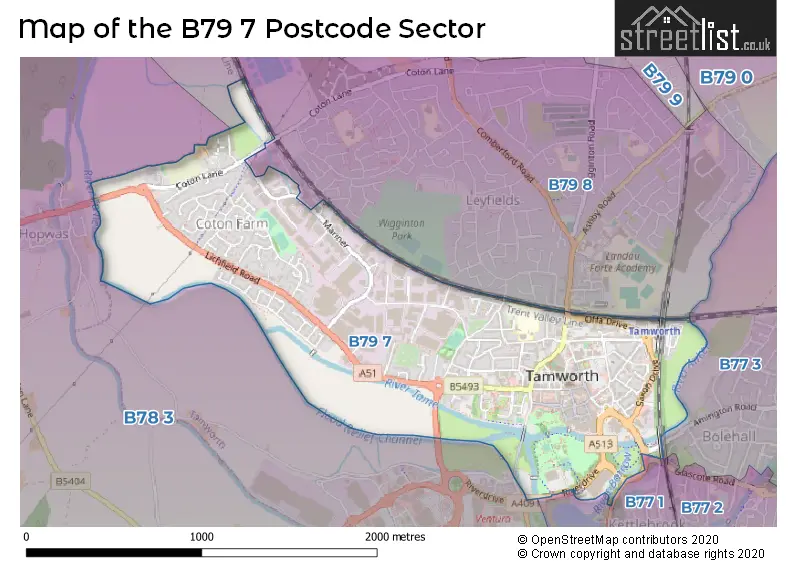
The B79 7 Postcode shares a border with WS14 9 (LICHFIELD, Whittington, Whittington Barracks), B77 1 (TAMWORTH, Dosthill, Two Gates), B77 3 (TAMWORTH, Amington, Bolehall), B78 3 (TAMWORTH, Fazeley, Mile Oak) and B79 8 (TAMWORTH).
The sector is within the post town of TAMWORTH.
B79 7 is a postcode sector within the B79 postcode district which is within the B Birmingham postcode area.
The Royal Mail delivery office for the B79 7 postal sector is the Tamworth Delivery Office.
The area of the B79 7 postcode sector is 1.23 square miles which is 3.17 square kilometres or 784.22 square acres.
Waterways within the B79 7 postcode sector include the River Tame.

Map of the B79 7 Postcode Sector
Explore the B79 7 postcode sector by using our free interactive map.
| B | 7 | 9 | - | 7 | X | X |
| B | 7 | 9 | Space | 7 | Letter | Letter |
Official List of Streets
TAMWORTH (106 Streets)
Unofficial Streets or Alternative Spellings
TAMWORTH
AMINGTON ROAD FAZELEY ROAD HARDWICK COURT ANDERS ANKERDRIVE APOLLO ARMSTRONG BORMAN CAVENDISH CONSORT PLACE DOG MUCK ALLEY DOWNING DRIVE GAGARIN HALFORD COURT HOLLOWAY KEPLER LADYBRIDGE LINCOLN AVENUE LOVELL MIDDLE ENTRY SHOPPING PRECINCT NEW STREET OFFADRIVE PAXTON PLACE PEELERS WAY PLANET WALK RIVERDRIVE ROSY CROFT SAINT EDITHAS CLOSE SAXONDRIVE STATION ROAD TAMEDRIVEHopwas
LICHFIELD ROADWeather Forecast for B79 7
Press Button to Show Forecast for Tamworth
| Time Period | Icon | Description | Temperature | Rain Probability | Wind |
|---|---|---|---|---|---|
| 12:00 to 15:00 | Cloudy | 8.0°C (feels like 6.0°C) | 13.00% | NNE 9 mph | |
| 15:00 to 18:00 | Overcast | 9.0°C (feels like 8.0°C) | 44.00% | NE 7 mph | |
| 18:00 to 21:00 | Cloudy | 8.0°C (feels like 6.0°C) | 34.00% | ENE 9 mph | |
| 21:00 to 00:00 | Cloudy | 7.0°C (feels like 4.0°C) | 7.00% | ENE 9 mph |
Press Button to Show Forecast for Tamworth
| Time Period | Icon | Description | Temperature | Rain Probability | Wind |
|---|---|---|---|---|---|
| 00:00 to 03:00 | Cloudy | 6.0°C (feels like 3.0°C) | 8.00% | ENE 9 mph | |
| 03:00 to 06:00 | Cloudy | 5.0°C (feels like 2.0°C) | 8.00% | NE 7 mph | |
| 06:00 to 09:00 | Cloudy | 5.0°C (feels like 2.0°C) | 8.00% | NE 9 mph | |
| 09:00 to 12:00 | Cloudy | 7.0°C (feels like 5.0°C) | 52.00% | ENE 11 mph | |
| 12:00 to 15:00 | Overcast | 8.0°C (feels like 5.0°C) | 51.00% | ENE 11 mph | |
| 15:00 to 18:00 | Light rain | 8.0°C (feels like 5.0°C) | 41.00% | NE 11 mph | |
| 18:00 to 21:00 | Overcast | 8.0°C (feels like 5.0°C) | 13.00% | NE 11 mph | |
| 21:00 to 00:00 | Overcast | 7.0°C (feels like 4.0°C) | 11.00% | NE 11 mph |
Press Button to Show Forecast for Tamworth
| Time Period | Icon | Description | Temperature | Rain Probability | Wind |
|---|---|---|---|---|---|
| 00:00 to 03:00 | Overcast | 6.0°C (feels like 3.0°C) | 12.00% | NNE 11 mph | |
| 03:00 to 06:00 | Overcast | 6.0°C (feels like 2.0°C) | 26.00% | NNE 11 mph | |
| 06:00 to 09:00 | Overcast | 6.0°C (feels like 3.0°C) | 51.00% | N 11 mph | |
| 09:00 to 12:00 | Heavy rain | 7.0°C (feels like 4.0°C) | 71.00% | NNW 9 mph | |
| 12:00 to 15:00 | Light rain | 9.0°C (feels like 6.0°C) | 48.00% | NW 9 mph | |
| 15:00 to 18:00 | Cloudy | 10.0°C (feels like 8.0°C) | 15.00% | WNW 9 mph | |
| 18:00 to 21:00 | Partly cloudy (day) | 10.0°C (feels like 8.0°C) | 8.00% | W 7 mph | |
| 21:00 to 00:00 | Clear night | 7.0°C (feels like 6.0°C) | 3.00% | SW 7 mph |
Press Button to Show Forecast for Tamworth
| Time Period | Icon | Description | Temperature | Rain Probability | Wind |
|---|---|---|---|---|---|
| 00:00 to 03:00 | Clear night | 6.0°C (feels like 4.0°C) | 1.00% | SW 7 mph | |
| 03:00 to 06:00 | Clear night | 5.0°C (feels like 2.0°C) | 2.00% | SSW 7 mph | |
| 06:00 to 09:00 | Partly cloudy (day) | 6.0°C (feels like 3.0°C) | 2.00% | S 7 mph | |
| 09:00 to 12:00 | Partly cloudy (day) | 10.0°C (feels like 8.0°C) | 2.00% | S 11 mph | |
| 12:00 to 15:00 | Overcast | 13.0°C (feels like 10.0°C) | 10.00% | S 13 mph | |
| 15:00 to 18:00 | Cloudy | 14.0°C (feels like 11.0°C) | 8.00% | S 13 mph | |
| 18:00 to 21:00 | Cloudy | 13.0°C (feels like 10.0°C) | 7.00% | S 11 mph | |
| 21:00 to 00:00 | Clear night | 10.0°C (feels like 8.0°C) | 3.00% | SSE 9 mph |
Press Button to Show Forecast for Tamworth
| Time Period | Icon | Description | Temperature | Rain Probability | Wind |
|---|---|---|---|---|---|
| 00:00 to 03:00 | Clear night | 8.0°C (feels like 6.0°C) | 4.00% | SSE 9 mph | |
| 03:00 to 06:00 | Clear night | 7.0°C (feels like 5.0°C) | 3.00% | SE 9 mph | |
| 06:00 to 09:00 | Sunny day | 8.0°C (feels like 6.0°C) | 4.00% | SE 9 mph | |
| 09:00 to 12:00 | Sunny day | 12.0°C (feels like 10.0°C) | 5.00% | SE 11 mph | |
| 12:00 to 15:00 | Partly cloudy (day) | 15.0°C (feels like 13.0°C) | 11.00% | SE 13 mph | |
| 15:00 to 18:00 | Cloudy | 16.0°C (feels like 14.0°C) | 12.00% | SE 11 mph | |
| 18:00 to 21:00 | Partly cloudy (day) | 15.0°C (feels like 13.0°C) | 10.00% | ESE 9 mph | |
| 21:00 to 00:00 | Cloudy | 12.0°C (feels like 11.0°C) | 11.00% | ESE 7 mph |
Schools and Places of Education Within the B79 7 Postcode Sector
Moorgate Primary Academy
Academy sponsor led
Moorgate, Tamworth, Staffordshire, B79 7EL
Head: Mr Jonathan Williams
Ofsted Rating: Good
Inspection: 2023-11-15 (163 days ago)
Website: Visit Moorgate Primary Academy Website
Phone: 01827215240
Number of Pupils: 310
Mortimer House School
Other independent special school
Mortimer House, Staffordshire, , B79 7HS
Head: Mrs Rebecca Bhageerutty
Ofsted Rating: Good
Inspection: 2023-04-28 (364 days ago)
Website: Visit Mortimer House School Website
Phone: 01827337998
Number of Pupils: 14
House Prices in the B79 7 Postcode Sector
| Type of Property | 2018 Average | 2018 Sales | 2017 Average | 2017 Sales | 2016 Average | 2016 Sales | 2015 Average | 2015 Sales |
|---|---|---|---|---|---|---|---|---|
| Detached | £274,590 | 25 | £274,226 | 19 | £253,600 | 14 | £239,576 | 19 |
| Semi-Detached | £173,203 | 17 | £177,778 | 18 | £158,186 | 21 | £166,360 | 29 |
| Terraced | £162,551 | 35 | £146,020 | 38 | £142,030 | 30 | £123,293 | 30 |
| Flats | £114,345 | 31 | £105,145 | 30 | £104,482 | 30 | £108,947 | 25 |
Important Postcodes B79 7 in the Postcode Sector
B79 7AP is the postcode for Staffordshire Magistrates Service, Spinning School Lane
B79 7BB is the postcode for Staffordshire Police, Tamworth Police Station, Spinning School Lane
B79 7BX is the postcode for Old Stone Cross, 33 Church Street
B79 7BZ is the postcode for Tamworth Borough Council, Marmion House, Lichfield Street
B79 7DJ is the postcode for Peel Medical Practice, 2 Aldergate
B79 7DN is the postcode for Assembly Rooms, Corporation Street, and The Enterprise Centre, Corporation Street
B79 7DW is the postcode for Staffordshire County Council, Tamworth Central Library, Corporation Street, and TAMWORTH LIBRARY, Corporation Street
B79 7EA is the postcode for Tamworth Health Centre, Upper Gungate
B79 7EE is the postcode for MIDDLE BLOCK, Moorgate Academy, Hospital Street, and Moorgate Academy, Hospital Street
B79 7EL is the postcode for MOORGATE PRIMARY ACADEMY SCHOOL, MOORGATE, TAMWORTH, Moorgate Primary School, Moorgate, Moorgate Primary Academy School, Moorgate, MOORGATE PRIMARY ACADEMY, HOSPITAL STREET, TAMWORTH, and Moorgate Primary Academy, Hospital Street
B79 7JJ is the postcode for 90 Saxon Mill Lane, and Jobcentre Plus, 90 Saxon Mill Lane
B79 7QL is the postcode for Staffordshire Fire & Rescue Service, Fire Station, Lichfield Street
B79 7QZ is the postcode for National Probation Service, Tamworth Probation Centre
| The B79 7 Sector is within these Local Authorities |
|
|---|---|
| The B79 7 Sector is within these Counties |
|
| The B79 7 Sector is within these Water Company Areas |
|