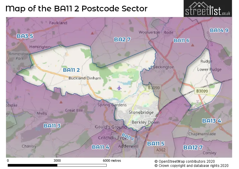
The BA11 2 postcode sector stands on the Somerset and Wiltshire border.
Did you know? According to the 2021 Census, the BA11 2 postcode sector is home to a bustling 10,265 residents!
Given that each sector allows for 400 unique postcode combinations. Letters C, I, K, M, O and V are not allowed in the last two letters of a postcode. With 310 postcodes already in use, this leaves 90 units available.
The largest settlement in the BA11 2 postal code is FROME followed by Buckland Dinham, and Standerwick.
The BA11 2 Postcode shares a border with BA3 5 (Coleford, Holcombe, Oakhill), BA11 1 (FROME), BA11 5 (FROME, Witham Friary, Trudoxhill), BA11 6 (Beckington, Rode), BA11 3 (FROME, Mells, Chantry), BA2 7 (Norton St. Philip, Limpley Stoke, Freshford) and BA13 4 (WESTBURY, Dilton Marsh, Bratton).
The sector is within the post town of FROME.
BA11 2 is a postcode sector within the BA1 postcode district which is within the BA Bath postcode area.
The Royal Mail delivery office for the BA11 2 postal sector is the Bath Delivery Office.
The area of the BA11 2 postcode sector is 11.11 square miles which is 28.77 square kilometres or 7,110.19 square acres.
The BA11 2 postcode sector is crossed by the A36 Major A road.
Waterways within the BA11 2 postcode sector include the River Frome, Buckland Brook, Mells River, Wheel Brook.

Map of the BA11 2 Postcode Sector
Explore the BA11 2 postcode sector by using our free interactive map.
| B | A | 1 | 1 | - | 2 | X | X |
| B | A | 1 | 1 | Space | 2 | Letter | Letter |
Official List of Streets
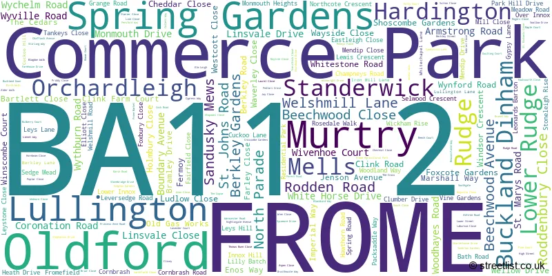
FROME (154 Streets)
Standerwick (6 Streets)
Buckland Dinham (8 Streets)
Commerce Park (5 Streets)
Spring Gardens (2 Streets)
Unofficial Streets or Alternative Spellings
Dilton Marsh
CLIVEY BURNT HILL LANE CASLEY LANE CHAMPNEY ROAD CLAREHAM LANE COALASH LANE COALWAY LANE COLLIERS LANE COLLIERS WAY COMMERCE PARK NEW ENTERPRISE ZONE COMMERCE PARK TRADE ZONE CONDUIT BRIDGE CONDUIT HILL DOWN LANE ELLIOT CLOSE ELLIOTS LANE ELM LANE FOXHOLES LANE FOXS DROVE HATCHET HILL HAWKS WORTH CLOSE INOX HILL JACKS LANE MILLARDS WAY MURTRY HILL LANE OLDFORD HILL PENNEYS PIECE PILLAR LANE ROGERS FARM BRIDGE ROSE DALE WALK RUDGE HILL SAINT MARYS ROAD SCOTLAND LANE SOUTHFIELD HILL TENNIS CORNER DROVE TREEWICK CLOSE WINDSBATCH HILL WINDSBATCH LANEBerkley
BERKLEY STREETBeckington
RUDGE LANE WHITECHAPEL LANEFROME
BRIDGE STREETWeather Forecast for BA11 2
Press Button to Show Forecast for Westbury (Wiltshire)
| Time Period | Icon | Description | Temperature | Rain Probability | Wind |
|---|---|---|---|---|---|
| 09:00 to 12:00 | Partly cloudy (day) | 12.0°C (feels like 12.0°C) | 1.00% | N 4 mph | |
| 12:00 to 15:00 | Cloudy | 15.0°C (feels like 15.0°C) | 13.00% | E 2 mph | |
| 15:00 to 18:00 | Heavy rain | 15.0°C (feels like 14.0°C) | 85.00% | N 4 mph | |
| 18:00 to 21:00 | Heavy rain | 12.0°C (feels like 11.0°C) | 90.00% | NW 7 mph | |
| 21:00 to 00:00 | Heavy rain | 11.0°C (feels like 10.0°C) | 89.00% | WNW 7 mph |
Press Button to Show Forecast for Westbury (Wiltshire)
| Time Period | Icon | Description | Temperature | Rain Probability | Wind |
|---|---|---|---|---|---|
| 00:00 to 03:00 | Cloudy | 12.0°C (feels like 10.0°C) | 52.00% | NW 7 mph | |
| 03:00 to 06:00 | Heavy rain | 11.0°C (feels like 10.0°C) | 85.00% | NNW 9 mph | |
| 06:00 to 09:00 | Light rain | 11.0°C (feels like 10.0°C) | 54.00% | NNE 7 mph | |
| 09:00 to 12:00 | Light rain | 12.0°C (feels like 11.0°C) | 46.00% | NNW 7 mph | |
| 12:00 to 15:00 | Overcast | 14.0°C (feels like 12.0°C) | 16.00% | NW 9 mph | |
| 15:00 to 18:00 | Overcast | 14.0°C (feels like 12.0°C) | 16.00% | WNW 11 mph | |
| 18:00 to 21:00 | Cloudy | 12.0°C (feels like 10.0°C) | 16.00% | WNW 11 mph | |
| 21:00 to 00:00 | Overcast | 11.0°C (feels like 9.0°C) | 19.00% | W 11 mph |
Press Button to Show Forecast for Westbury (Wiltshire)
| Time Period | Icon | Description | Temperature | Rain Probability | Wind |
|---|---|---|---|---|---|
| 00:00 to 03:00 | Overcast | 10.0°C (feels like 8.0°C) | 18.00% | WNW 11 mph | |
| 03:00 to 06:00 | Light rain | 10.0°C (feels like 8.0°C) | 44.00% | W 11 mph | |
| 06:00 to 09:00 | Light rain | 10.0°C (feels like 8.0°C) | 44.00% | W 11 mph | |
| 09:00 to 12:00 | Light rain | 12.0°C (feels like 9.0°C) | 42.00% | W 13 mph | |
| 12:00 to 15:00 | Cloudy | 13.0°C (feels like 11.0°C) | 10.00% | W 13 mph | |
| 15:00 to 18:00 | Cloudy | 14.0°C (feels like 12.0°C) | 8.00% | W 11 mph | |
| 18:00 to 21:00 | Partly cloudy (day) | 13.0°C (feels like 11.0°C) | 5.00% | W 9 mph | |
| 21:00 to 00:00 | Clear night | 10.0°C (feels like 8.0°C) | 4.00% | W 7 mph |
Press Button to Show Forecast for Westbury (Wiltshire)
| Time Period | Icon | Description | Temperature | Rain Probability | Wind |
|---|---|---|---|---|---|
| 00:00 to 03:00 | Clear night | 8.0°C (feels like 7.0°C) | 3.00% | WSW 7 mph | |
| 03:00 to 06:00 | Clear night | 7.0°C (feels like 6.0°C) | 4.00% | SW 7 mph | |
| 06:00 to 09:00 | Cloudy | 9.0°C (feels like 7.0°C) | 7.00% | SSW 7 mph | |
| 09:00 to 12:00 | Cloudy | 13.0°C (feels like 11.0°C) | 8.00% | SW 9 mph | |
| 12:00 to 15:00 | Light rain | 14.0°C (feels like 13.0°C) | 39.00% | SW 11 mph | |
| 15:00 to 18:00 | Light rain | 15.0°C (feels like 13.0°C) | 50.00% | SSW 11 mph | |
| 18:00 to 21:00 | Cloudy | 14.0°C (feels like 12.0°C) | 9.00% | SSW 9 mph | |
| 21:00 to 00:00 | Overcast | 12.0°C (feels like 10.0°C) | 11.00% | SSW 7 mph |
Schools and Places of Education Within the BA11 2 Postcode Sector
Frome Community College
Community school
Bath Road, Frome, Somerset, BA11 2HQ
Head: Ms Emma Reynolds
Ofsted Rating: Good
Inspection: 2023-10-05 (209 days ago)
Website: Visit Frome Community College Website
Phone: 01373465353
Number of Pupils: 1283
Hayesdown First School
Academy sponsor led
Wyville Road, Frome, Somerset, BA11 2BN
Head: Mrs Julia Battersby
Ofsted Rating: Good
Inspection: 2018-12-05 (1974 days ago)
Website: Visit Hayesdown First School Website
Phone: 01373462718
Number of Pupils: 298
North Hill House
Other independent special school
Fromefield, Frome, Somerset, BA11 2HB
Head: Mr Michael Pearce
Ofsted Rating: Requires improvement
Inspection: 2022-09-29 (580 days ago)
Website: Visit North Hill House Website
Phone: 01373466222
Number of Pupils: 50
Selwood Academy
Academy converter
Berkley Road, Frome, Somerset, BA11 2EF
Head: Mr Daniel Jeffries
Ofsted Rating: Good
Inspection: 2022-06-29 (672 days ago)
Website: Visit Selwood Academy Website
Phone: 01373462798
Number of Pupils: 607
House Prices in the BA11 2 Postcode Sector
| Type of Property | 2018 Average | 2018 Sales | 2017 Average | 2017 Sales | 2016 Average | 2016 Sales | 2015 Average | 2015 Sales |
|---|---|---|---|---|---|---|---|---|
| Detached | £407,785 | 59 | £457,685 | 63 | £354,006 | 70 | £319,647 | 78 |
| Semi-Detached | £288,524 | 48 | £263,606 | 56 | £226,705 | 62 | £202,787 | 54 |
| Terraced | £212,763 | 53 | £203,213 | 57 | £201,504 | 65 | £164,069 | 73 |
| Flats | £190,988 | 4 | £163,667 | 3 | £148,477 | 11 | £118,249 | 4 |
Important Postcodes BA11 2 in the Postcode Sector
BA11 2BN is the postcode for Hayesdown First School, Wyville Road
BA11 2EF is the postcode for Selwood Middle School, Berkley Road
BA11 2FH is the postcode for Frome Medical Centre, Frome Medical Centre, Enos Way, Frome Medical Centre, Enos Way, and Frome Community Hospital, Enos Way
BA11 2HQ is the postcode for NORTHCOTE BLOCK, Frome Community College, Bath Road, TECHNOLOGY BLOCK, Frome Community College, Bath Road, and Frome Community College, Bath Road
BA11 2SA is the postcode for Frome Leisure Centre, Princess Anne Road, and Avalon Leisure Ltd, Frome Leisure Centre
| The BA11 2 Sector is within these Local Authorities |
|
|---|---|
| The BA11 2 Sector is within these Counties |
|
| The BA11 2 Sector is within these Water Company Areas |
|