The BA2 7 postcode sector stands on the Somerset and Wiltshire border.
Did you know? According to the 2021 Census, the BA2 7 postcode sector is home to a bustling 7,866 residents!
Given that each sector allows for 400 unique postcode combinations. Letters C, I, K, M, O and V are not allowed in the last two letters of a postcode. With 291 postcodes already in use, this leaves 109 units available.
The largest settlement in the BA2 7 postal code is Norton St. Philip followed by Limpley Stoke, and Freshford.
The BA2 7 Postcode shares a border with BA2 8 (Peasedown St. John, Wellow, Shoscombe), BA3 5 (Coleford, Holcombe, Oakhill), BA11 2 (FROME, Buckland Dinham, Standerwick), BA11 6 (Beckington, Rode), BA14 9 (TROWBRIDGE, Southwick, Wingfield), BA15 2 (Winsley, BRADFORD-ON-AVON, Lower Westwood), BA1 8 (Upper Swainswick, BATH, St. Catherine), BA2 2 (BATH), BA2 5 (BATH, Combe Down) and BA2 6 (BATH, Bathampton, Bathwick).
The sector is within the post town of BATH.
BA2 7 is a postcode sector within the BA2 postcode district which is within the BA Bath postcode area.
The Royal Mail delivery office for the BA2 7 postal sector is the Bath Delivery Office and Freshford Scale Payment Delivery Office and Limpley Stoke Scale Payment Delivery Office.
The area of the BA2 7 postcode sector is 18.82 square miles which is 48.73 square kilometres or 12,041.71 square acres.
The BA2 7 postcode sector is crossed by the A36 Major A road.
Waterways within the BA2 7 postcode sector include the Kennet and Avon Canal, River Avon, River Frome, Cam Brook, Wellow Brook, Henhambridge Brook, Wheel Brook.

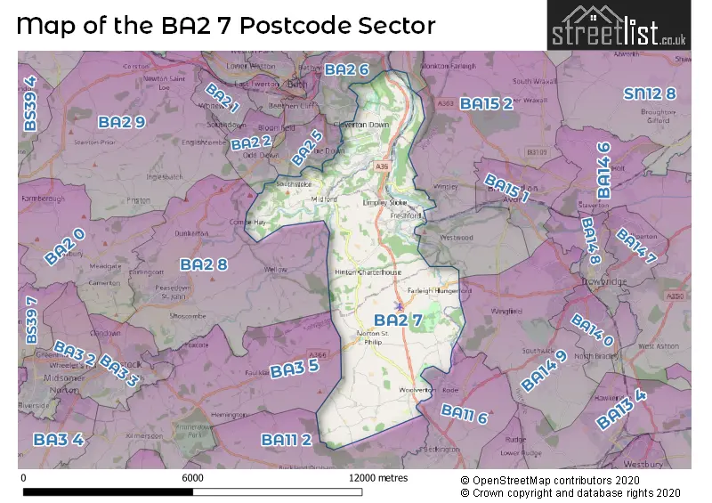
Map of the BA2 7 Postcode Sector
Explore the BA2 7 postcode sector by using our free interactive map.
| B | A | 2 | - | 7 | X | X |
| B | A | 2 | Space | 7 | Letter | Letter |
Official List of Streets
Hinton Charterhouse (13 Streets)
Freshford (21 Streets)
Limpley Stoke (18 Streets)
Norton St. Philip (27 Streets)
BATH (4 Streets)
Monkton Combe (10 Streets)
Claverton Down (7 Streets)
Combe Down (5 Streets)
Claverton (2 Streets)
South Stoke (6 Streets)
Midford (3 Streets)
Unofficial Streets or Alternative Spellings
Bathampton
WARMINSTER ROADBuckland Dinham
COCK ROADWellow
NORTON LANEWeather Forecast for BA2 7
Press Button to Show Forecast for Iford Manor
| Time Period | Icon | Description | Temperature | Rain Probability | Wind |
|---|---|---|---|---|---|
| 21:00 to 00:00 | Light rain | 8.0°C (feels like 6.0°C) | 55.00% | E 7 mph |
Press Button to Show Forecast for Iford Manor
| Time Period | Icon | Description | Temperature | Rain Probability | Wind |
|---|---|---|---|---|---|
| 00:00 to 03:00 | Light rain | 7.0°C (feels like 5.0°C) | 76.00% | ENE 7 mph | |
| 03:00 to 06:00 | Heavy rain | 6.0°C (feels like 3.0°C) | 80.00% | ENE 9 mph | |
| 06:00 to 09:00 | Overcast | 6.0°C (feels like 3.0°C) | 18.00% | NE 9 mph | |
| 09:00 to 12:00 | Overcast | 7.0°C (feels like 4.0°C) | 15.00% | NE 11 mph | |
| 12:00 to 15:00 | Cloudy | 10.0°C (feels like 7.0°C) | 9.00% | ENE 9 mph | |
| 15:00 to 18:00 | Cloudy | 10.0°C (feels like 8.0°C) | 13.00% | NE 11 mph | |
| 18:00 to 21:00 | Cloudy | 9.0°C (feels like 7.0°C) | 12.00% | NE 11 mph | |
| 21:00 to 00:00 | Cloudy | 8.0°C (feels like 5.0°C) | 16.00% | NNE 11 mph |
Press Button to Show Forecast for Iford Manor
| Time Period | Icon | Description | Temperature | Rain Probability | Wind |
|---|---|---|---|---|---|
| 00:00 to 03:00 | Light rain | 7.0°C (feels like 4.0°C) | 51.00% | NNE 11 mph | |
| 03:00 to 06:00 | Light rain | 6.0°C (feels like 3.0°C) | 55.00% | N 11 mph | |
| 06:00 to 09:00 | Heavy rain | 6.0°C (feels like 2.0°C) | 81.00% | NNW 11 mph | |
| 09:00 to 12:00 | Light rain | 7.0°C (feels like 4.0°C) | 56.00% | NNW 11 mph | |
| 12:00 to 15:00 | Overcast | 9.0°C (feels like 6.0°C) | 20.00% | NW 9 mph | |
| 15:00 to 18:00 | Cloudy | 10.0°C (feels like 8.0°C) | 12.00% | WNW 9 mph | |
| 18:00 to 21:00 | Sunny day | 10.0°C (feels like 8.0°C) | 4.00% | WSW 9 mph | |
| 21:00 to 00:00 | Clear night | 7.0°C (feels like 5.0°C) | 1.00% | WSW 7 mph |
Press Button to Show Forecast for Iford Manor
| Time Period | Icon | Description | Temperature | Rain Probability | Wind |
|---|---|---|---|---|---|
| 00:00 to 03:00 | Clear night | 5.0°C (feels like 3.0°C) | 1.00% | SW 7 mph | |
| 03:00 to 06:00 | Clear night | 4.0°C (feels like 2.0°C) | 1.00% | SSW 7 mph | |
| 06:00 to 09:00 | Sunny day | 6.0°C (feels like 4.0°C) | 2.00% | S 7 mph | |
| 09:00 to 12:00 | Partly cloudy (day) | 11.0°C (feels like 8.0°C) | 4.00% | S 13 mph | |
| 12:00 to 15:00 | Cloudy | 13.0°C (feels like 10.0°C) | 8.00% | S 16 mph | |
| 15:00 to 18:00 | Partly cloudy (day) | 13.0°C (feels like 10.0°C) | 6.00% | S 16 mph | |
| 18:00 to 21:00 | Sunny day | 11.0°C (feels like 9.0°C) | 4.00% | S 11 mph | |
| 21:00 to 00:00 | Clear night | 9.0°C (feels like 6.0°C) | 4.00% | SSE 9 mph |
Press Button to Show Forecast for Iford Manor
| Time Period | Icon | Description | Temperature | Rain Probability | Wind |
|---|---|---|---|---|---|
| 00:00 to 03:00 | Clear night | 8.0°C (feels like 6.0°C) | 3.00% | SE 9 mph | |
| 03:00 to 06:00 | Clear night | 8.0°C (feels like 5.0°C) | 4.00% | SE 9 mph | |
| 06:00 to 09:00 | Sunny day | 9.0°C (feels like 6.0°C) | 6.00% | SE 9 mph | |
| 09:00 to 12:00 | Partly cloudy (day) | 12.0°C (feels like 10.0°C) | 10.00% | SE 13 mph | |
| 12:00 to 15:00 | Cloudy | 14.0°C (feels like 11.0°C) | 15.00% | SSE 13 mph | |
| 15:00 to 18:00 | Cloudy | 14.0°C (feels like 12.0°C) | 17.00% | SSE 11 mph | |
| 18:00 to 21:00 | Cloudy | 13.0°C (feels like 11.0°C) | 13.00% | SE 9 mph | |
| 21:00 to 00:00 | Partly cloudy (night) | 10.0°C (feels like 8.0°C) | 8.00% | SE 7 mph |
Schools and Places of Education Within the BA2 7 Postcode Sector
Freshford Church School
Academy converter
High Street, Bath, Somerset, BA2 7WE
Head: Mr Andrew Wishart
Ofsted Rating: Good
Inspection: 2022-06-30 (666 days ago)
Website: Visit Freshford Church School Website
Phone: 01225723331
Number of Pupils: 155
Norton St Philip Church of England First School
Voluntary aided school
Church Street, Bath, Somerset, BA2 7LU
Head: Mrs Georgina Muxworthy
Ofsted Rating: Good
Inspection: 2022-12-08 (505 days ago)
Website: Visit Norton St Philip Church of England First School Website
Phone: 01373834327
Number of Pupils: 55
Ralph Allen School
Academy converter
Claverton Down Road, Bath, Somerset, BA2 7AD
Head: Mr Nathan Jenkins
Ofsted Rating: Good
Inspection: 2018-03-13 (2236 days ago)
Website: Visit Ralph Allen School Website
Phone: 01225832936
Number of Pupils: 1371
House Prices in the BA2 7 Postcode Sector
| Type of Property | 2018 Average | 2018 Sales | 2017 Average | 2017 Sales | 2016 Average | 2016 Sales | 2015 Average | 2015 Sales |
|---|---|---|---|---|---|---|---|---|
| Detached | £885,636 | 33 | £699,158 | 49 | £741,087 | 54 | £819,333 | 30 |
| Semi-Detached | £546,500 | 8 | £465,719 | 16 | £414,228 | 23 | £478,370 | 14 |
| Terraced | £429,180 | 11 | £384,850 | 12 | £395,974 | 27 | £360,810 | 24 |
| Flats | £363,592 | 13 | £346,003 | 17 | £285,036 | 14 | £295,759 | 16 |
Important Postcodes BA2 7 in the Postcode Sector
BA2 7AD is the postcode for Katherine Johnson Building, Ralph Allen School, Claverton Down Road, M Block, Ralph Allen School, Claverton Down Road, S Block, Ralph Allen School, Claverton Down Road, SPORTS HALL, Ralph Allen School, Claverton Down Road, Construction, Ralph Allen School, Claverton Down Road, THE ROSE BUILDING, Ralph Allen School, Claverton Down Road, PRACTICAL BLOCK, Ralph Allen School, Claverton Down Road, L Block, Ralph Allen School, Claverton Down Road, THE LEE CENTRE, Ralph Allen School, Claverton Down Road, P Block, Ralph Allen School, Claverton Down Road, Ralph Allen School, Claverton Down Road, LIBRARY, Ralph Allen School, Claverton Down Road, Dining Hall, Ralph Allen School, Claverton Down Road, Z Block, Ralph Allen School, Claverton Down Road, MAIN BUILDING, Ralph Allen School, Claverton Down Road, and SCIENCE BLOCK, Ralph Allen School, Claverton Down Road
BA2 7AU is the postcode for Sulis Sports Club, University of Bath, Claverton Down Road
BA2 7AY is the postcode for MENDIP, University of Bath, The Avenue, 3 WEST, University of Bath, The Avenue, POLDEN COURT, University of Bath, The Avenue, SOLSBURY COURT, University of Bath, The Avenue, ESTHER PARKIN (K), University of Bath, The Avenue, EAST BUILDING UNIVERSITY OF BATH, University of Bath, The Avenue, MARLBOROUGH COURT, University of Bath, The Avenue, 6 WEST SOUTH, University of Bath, The Avenue, WOLFSON, University of Bath, The Avenue, THE MILNER BUILDING, University of Bath, The Avenue, WESSEX HOUSE, University of Bath, The Avenue, 8 WEST, University of Bath, The Avenue, SPORTS TRAINING VILLAGE, University of Bath, The Avenue, 3 EAST, University of Bath, The Avenue, DERHILL, University of Bath, The Avenue, 4 WEST UNIVERSITY OF BATH, University of Bath, The Avenue, 1 WEST NORTH, University of Bath, The Avenue, 1 SOUTH, University of Bath, The Avenue, 1 EAST, University of Bath, The Avenue, 4 SOUTH, University of Bath, The Avenue, 3 WEST NORTH, University of Bath, The Avenue, 10 WEST UNIVERSITY OF BATH, University of Bath, The Avenue, CONYGRE, University of Bath, The Avenue, University of Bath, The Avenue, 5W GLAXO, University of Bath, The Avenue, 4 EAST, University of Bath, The Avenue, BRENDON COURT, University of Bath, The Avenue, ESTATES OFFICE, University of Bath, The Avenue, 4 EAST SOUTH, University of Bath, The Avenue, QUARRY, University of Bath, The Avenue, 2 SOUTH, University of Bath, The Avenue, 7 WEST, University of Bath, The Avenue, 8 EAST, University of Bath, The Avenue, THE QUADS D, University of Bath, The Avenue, 5 WEST, University of Bath, The Avenue, COTSWOLD, University of Bath, The Avenue, UNIVERSITY OF BATH GTA BUILDING, University of Bath, The Avenue, 1 WEST, University of Bath, The Avenue, CENTRAL STORES AND 5 SOUTH, University of Bath, The Avenue, WOODLAND COURT, University of Bath, The Avenue, NORWOOD HOUSE, University of Bath, The Avenue, STUDENT CENTRE UNIVERSITY OF BATH, University of Bath, The Avenue, CHANCELLORS' BUILDING, University of Bath, The Avenue, WESTWOOD NURSERY, University of Bath, The Avenue, 9 WEST, University of Bath, The Avenue, 6 EAST, University of Bath, The Avenue, 6 WEST, University of Bath, The Avenue, THE QUADS A, University of Bath, The Avenue, 2 WEST, University of Bath, The Avenue, THE EDGE, University of Bath, The Avenue, LIBRARY, University of Bath, The Avenue, 3 SOUTH, University of Bath, The Avenue, 2 EAST, University of Bath, The Avenue, FOUNDERS HALL, University of Bath, The Avenue, and QUANTOCK, University of Bath, The Avenue
BA2 7BR is the postcode for Bath Clinic, Claverton Down Road, Combe Down
BA2 7JX is the postcode for EASTWOOD OFFICES 20-21 (D), Eastwood Complex University of Bath, Claverton Down
BA2 7PB is the postcode for The Chancellors Building, University of Bath
BA2 7PS is the postcode for Polden University of Bath, Claverton Down
BA2 7WE is the postcode for OLD BUILDING, Freshford VC Primary School, High Street, and Freshford VC Primary School, High Street
| The BA2 7 Sector is within these Local Authorities |
|
|---|---|
| The BA2 7 Sector is within these Counties |
|
| The BA2 7 Sector is within these Water Company Areas |
|
Tourist Attractions within the BA2 7 Postcode Area
We found 1 visitor attractions within the BA2 postcode area
| Farleigh Hungerford Castle |
|---|
| Historic Properties |
| Castle / Fort |
| View Farleigh Hungerford Castle on Google Maps |