The BA11 postcode district is a postal district located in the BA Bath postcode area with a population of 35,288 residents according to the 2021 England and Wales Census.
The area of the BA11 postcode district is 54.75 square miles which is 141.79 square kilometres or 35,037.80 acres.
Currently, the BA11 district has about 1141 postcode units spread across 6 geographic postcode sectors.
Given that each sector allows for 400 unique postcode combinations, the district has a capacity of 2,400 postcodes. With 1141 postcodes already in use, this leaves 1259 units available.
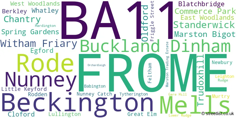
The largest settlement in the BA11 postal code is FROME followed by Beckington, and Rode.
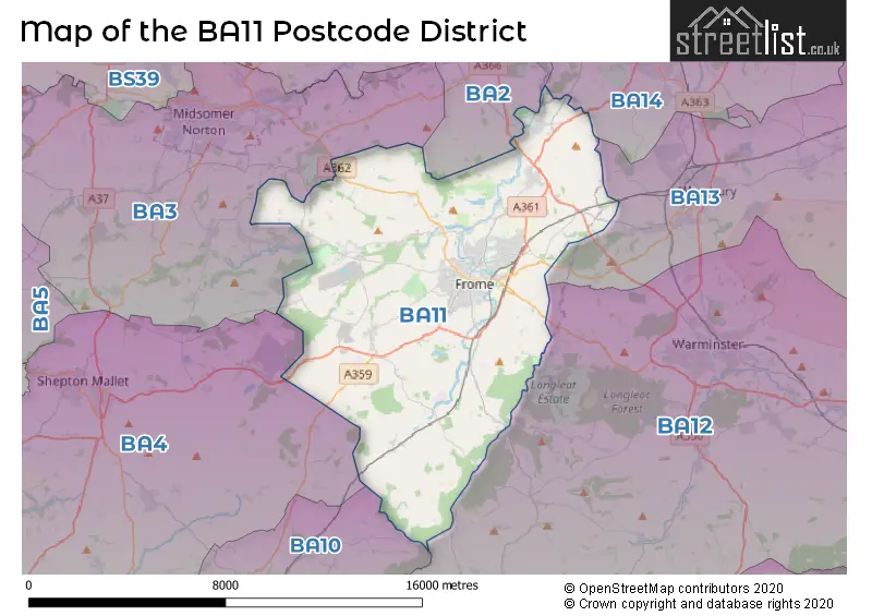
The BA11 Postcode shares a border with BA14 (TROWBRIDGE, Hilperton, Southwick), BA2 (BATH, Peasedown St. John, Timsbury), BA3 (Midsomer Norton, Westfield, RADSTOCK) and BA12 (WARMINSTER, Mere, Codford).
The primary settlement in the BA11 postcode district is Frome, located in the county of Somerset in England. Other significant settlements in the district include Buckland Dinham, Commerce Park, Hardington, Lower Rudge, Lullington, Mells, Murtry, Oldford, Orchardleigh, Rudge, Spring Gardens, and Standerwick. The most significant post town in the district is Frome.
For the district BA11, we have data on 7 postcode sectors. Here's a breakdown: The sector BA11 1, covers Frome in Somerset. The sector BA11 2, covers Frome in Somerset. The sector BA11 3, covers Frome and Mells in Somerset. The sector BA11 4, covers Frome and Nunney in Somerset. The sector BA11 5, covers Frome and Witham Friary in Somerset. The sector BA11 6, covers Beckington and Rode in Somerset. The sector BA11 9 is non-geographic. It's often designated for PO Boxes, large organisations, or special services.

Map of the BA11 Postcode District
Explore the BA11 postcode district by using our free interactive map.
When it comes to local government, postal geography often disregards political borders. However, for a breakdown in the BA11 District: the district mostly encompasses the Somerset (1148 postcodes), and finally, the Wiltshire area (4 postcodes).
Weather Forecast for BA11
Press Button to Show Forecast for Frome
| Time Period | Icon | Description | Temperature | Rain Probability | Wind |
|---|---|---|---|---|---|
| 06:00 to 09:00 | Overcast | 6.0°C (feels like 3.0°C) | 19.00% | NE 9 mph | |
| 09:00 to 12:00 | Overcast | 8.0°C (feels like 5.0°C) | 13.00% | NE 11 mph | |
| 12:00 to 15:00 | Overcast | 10.0°C (feels like 7.0°C) | 12.00% | NE 11 mph | |
| 15:00 to 18:00 | Cloudy | 11.0°C (feels like 9.0°C) | 13.00% | NE 11 mph | |
| 18:00 to 21:00 | Cloudy | 10.0°C (feels like 7.0°C) | 13.00% | NNE 11 mph | |
| 21:00 to 00:00 | Overcast | 8.0°C (feels like 5.0°C) | 20.00% | NNE 11 mph |
Press Button to Show Forecast for Frome
| Time Period | Icon | Description | Temperature | Rain Probability | Wind |
|---|---|---|---|---|---|
| 00:00 to 03:00 | Light rain | 7.0°C (feels like 4.0°C) | 56.00% | NNE 11 mph | |
| 03:00 to 06:00 | Heavy rain | 6.0°C (feels like 3.0°C) | 85.00% | N 11 mph | |
| 06:00 to 09:00 | Heavy rain | 6.0°C (feels like 3.0°C) | 81.00% | NNW 11 mph | |
| 09:00 to 12:00 | Light rain | 7.0°C (feels like 4.0°C) | 56.00% | NNW 11 mph | |
| 12:00 to 15:00 | Overcast | 9.0°C (feels like 7.0°C) | 19.00% | NW 9 mph | |
| 15:00 to 18:00 | Cloudy | 10.0°C (feels like 8.0°C) | 12.00% | WNW 9 mph | |
| 18:00 to 21:00 | Sunny day | 10.0°C (feels like 8.0°C) | 4.00% | WSW 9 mph | |
| 21:00 to 00:00 | Clear night | 7.0°C (feels like 5.0°C) | 1.00% | WSW 7 mph |
Press Button to Show Forecast for Frome
| Time Period | Icon | Description | Temperature | Rain Probability | Wind |
|---|---|---|---|---|---|
| 00:00 to 03:00 | Clear night | 5.0°C (feels like 3.0°C) | 1.00% | SW 7 mph | |
| 03:00 to 06:00 | Clear night | 4.0°C (feels like 2.0°C) | 1.00% | SSW 7 mph | |
| 06:00 to 09:00 | Sunny day | 6.0°C (feels like 4.0°C) | 2.00% | S 7 mph | |
| 09:00 to 12:00 | Partly cloudy (day) | 11.0°C (feels like 8.0°C) | 4.00% | S 13 mph | |
| 12:00 to 15:00 | Cloudy | 13.0°C (feels like 10.0°C) | 8.00% | S 16 mph | |
| 15:00 to 18:00 | Partly cloudy (day) | 13.0°C (feels like 10.0°C) | 6.00% | S 16 mph | |
| 18:00 to 21:00 | Sunny day | 12.0°C (feels like 9.0°C) | 4.00% | S 11 mph | |
| 21:00 to 00:00 | Clear night | 9.0°C (feels like 6.0°C) | 4.00% | SSE 9 mph |
Press Button to Show Forecast for Frome
| Time Period | Icon | Description | Temperature | Rain Probability | Wind |
|---|---|---|---|---|---|
| 00:00 to 03:00 | Clear night | 8.0°C (feels like 6.0°C) | 3.00% | SE 9 mph | |
| 03:00 to 06:00 | Clear night | 8.0°C (feels like 6.0°C) | 4.00% | SE 9 mph | |
| 06:00 to 09:00 | Sunny day | 9.0°C (feels like 6.0°C) | 6.00% | SE 9 mph | |
| 09:00 to 12:00 | Partly cloudy (day) | 12.0°C (feels like 10.0°C) | 10.00% | SE 13 mph | |
| 12:00 to 15:00 | Cloudy | 14.0°C (feels like 12.0°C) | 15.00% | SSE 13 mph | |
| 15:00 to 18:00 | Cloudy | 15.0°C (feels like 12.0°C) | 17.00% | SSE 11 mph | |
| 18:00 to 21:00 | Cloudy | 13.0°C (feels like 11.0°C) | 13.00% | SE 9 mph | |
| 21:00 to 00:00 | Partly cloudy (night) | 10.0°C (feels like 9.0°C) | 8.00% | SE 7 mph |
Where is the BA11 Postcode District?
The postcode district BA11 is located in the town of Frome. It is surrounded by several nearby towns. To the North West, there is Radstock, which is approximately 6.57 miles away. Warminster is situated to the East, about 6.86 miles away. Heading South West, you will find Bruton at a distance of approximately 8.76 miles. Trowbridge is located to the North East, roughly 9.10 miles away. Shepton Mallet is situated to the West, approximately 9.19 miles away. Finally, the town of Bath is located to the North, at a distance of approximately 11.32 miles. Frome is also 97.82 miles away from the centre of London.
The district is within the post town of FROME.
The sector has postcodes within the nation of England.
The BA11 Postcode District is covers the following regions.
- Somerset - Dorset and Somerset - South West (England)
- Bath and North East Somerset, North Somerset and South Gloucestershire - Gloucestershire, Wiltshire and Bath/Bristol area - South West (England)
- Wiltshire - Gloucestershire, Wiltshire and Bath/Bristol area - South West (England)
| Postcode Sector | Delivery Office |
|---|---|
| BA11 1 | Frome Delivery Office |
| BA11 2 | Frome Delivery Office |
| BA11 3 | Frome Delivery Office |
| BA11 4 | Frome Delivery Office |
| BA11 5 | Frome Delivery Office |
| BA11 6 | Frome Delivery Office |
| B | A | 1 | 1 | - | X | X | X |
| B | A | 1 | 1 | Space | Numeric | Letter | Letter |
Current Monthly Rental Prices
| # Bedrooms | Min Price | Max Price | Avg Price |
|---|---|---|---|
| 1 | £725 | £825 | £805 |
| 2 | £950 | £1,250 | £1,085 |
| 3 | £995 | £2,000 | £1,413 |
| 4 | £1,395 | £3,500 | £2,065 |
Current House Prices
| # Bedrooms | Min Price | Max Price | Avg Price |
|---|---|---|---|
| £1,000,000 | £1,000,000 | £1,000,000 | |
| 2 | £895,000 | £895,000 | £895,000 |
| 3 | £800,000 | £800,000 | £800,000 |
| 4 | £800,000 | £2,450,000 | £1,183,222 |
| 5 | £795,000 | £1,150,000 | £927,778 |
| 6 | £800,000 | £1,200,000 | £1,000,000 |
| 10 | £2,650,000 | £2,650,000 | £2,650,000 |
Estate Agents who Operate in the BA11 District
| Logo | Name | Brand Name | Address | Contact Number | Total Properties |
|---|---|---|---|---|---|
 | Frome | Cooper & Tanner | 6 The Bridge, Frome, BA11 1AR | 01373 481067 | 50 |
 | Frome | McAllisters | 13 Market Place, Frome, BA11 1AB | 01373 481219 | 46 |
 | Frome | Allen & Harris | 9 The Bridge, Frome, Somerset, BA11 1AR | 01373 481677 | 36 |
 | Frome | Hunter French | 19 Paul Street, Frome BA11 1DT | 01373 481053 | 20 |
 | Frome | Forest Marble | 4 Harris Close, Elworthy Park, Frome, BA11 5JY | 01373 485187 | 18 |
- Beckington
- Berkley
- Berkley Marsh
- Buckland Dinham
- Chantry
- Church Row
- Coleford
- Dilton Marsh
- East Woodlands
- Egford
- Elliots Green
- Frome
- Great Elm
- Hapsford
- Hemington
- Horningsham
- Kilmersdon
- Kilmington
- Leigh upon Mendip
- Leighton
- Little Keyford
- Lower Marston
- Lullington
- Maiden Bradley
- Mells
- Nunney Catch
- Nunney
- Oldford
- Ridgeway
- Rode
- Rudge
- Shawford
- Trudoxhill
- Tytherington
- Upper Vobster
- Wanstrow
- Witham Friary
- Woolverton
| Type of Property | 2018 Average | 2018 Sales | 2017 Average | 2017 Sales | 2016 Average | 2016 Sales | 2015 Average | 2015 Sales |
|---|---|---|---|---|---|---|---|---|
| Detached | £447,118 | 217 | £437,874 | 185 | £414,944 | 155 | £346,062 | 146 |
| Semi-Detached | £304,208 | 188 | £281,435 | 180 | £248,571 | 137 | £223,565 | 142 |
| Terraced | £258,023 | 244 | £249,580 | 291 | £236,327 | 262 | £203,619 | 267 |
| Flats | £162,703 | 60 | £154,512 | 68 | £126,216 | 97 | £124,125 | 82 |