The BA21 postcode district is a postal district located in the BA Bath postcode area with a population of 36,198 residents according to the 2021 England and Wales Census.
The area of the BA21 postcode district is 7.91 square miles which is 20.49 square kilometres or 5,063.97 acres.
Currently, the BA21 district has about 768 postcode units spread across 3 geographic postcode sectors.
Given that each sector allows for 400 unique postcode combinations, the district has a capacity of 1,200 postcodes. With 768 postcodes already in use, this leaves 432 units available.
The largest settlement in the BA21 postal code is YEOVIL followed by Mudford, and Pen Mill Trading Estate.
The BA21 Postcode shares a border with BA22 (Ilchester, East Coker, West Coker), DT9 (SHERBORNE, Milborne Port, Yetminster) and BA20 (YEOVIL, Lynx Trading Estate, Lynx West Trading Estate).
The primary settlement in the BA21 postcode district is Yeovil, located in the county of Somerset, England. Other significant settlements in the district include Brimsmore, Chilthorne Domer, Thorne, and Yeovil Marsh. The most significant post town in the district is Yeovil.
For the district BA21, we have data on 3 postcode sectors. Here's a breakdown: The sector BA21 3, covers Yeovil in Somerset. The sector BA21 4, covers Yeovil in Somerset. The sector BA21 5, covers Yeovil in Somerset.

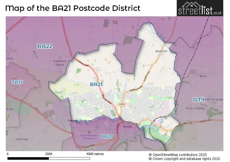
Map of the BA21 Postcode District
Explore the BA21 postcode district by using our free interactive map.
When it comes to local government, postal geography often disregards political borders. However, for a breakdown in the BA21 District: the district mostly encompasses the Somerset (768 postcodes), and finally, the Dorset area (5 postcodes).
Weather Forecast for BA21
Press Button to Show Forecast for Yeovil
| Time Period | Icon | Description | Temperature | Rain Probability | Wind |
|---|---|---|---|---|---|
| 12:00 to 15:00 | Cloudy | 11.0°C (feels like 9.0°C) | 14.00% | NE 9 mph | |
| 15:00 to 18:00 | Cloudy | 12.0°C (feels like 10.0°C) | 54.00% | ENE 9 mph | |
| 18:00 to 21:00 | Cloudy | 10.0°C (feels like 8.0°C) | 15.00% | NE 9 mph | |
| 21:00 to 00:00 | Cloudy | 9.0°C (feels like 6.0°C) | 19.00% | NNE 11 mph |
Press Button to Show Forecast for Yeovil
| Time Period | Icon | Description | Temperature | Rain Probability | Wind |
|---|---|---|---|---|---|
| 00:00 to 03:00 | Overcast | 7.0°C (feels like 4.0°C) | 57.00% | NNE 11 mph | |
| 03:00 to 06:00 | Heavy rain | 7.0°C (feels like 3.0°C) | 86.00% | N 11 mph | |
| 06:00 to 09:00 | Heavy rain | 6.0°C (feels like 3.0°C) | 86.00% | NNW 11 mph | |
| 09:00 to 12:00 | Light rain | 8.0°C (feels like 5.0°C) | 54.00% | NNW 11 mph | |
| 12:00 to 15:00 | Overcast | 10.0°C (feels like 7.0°C) | 17.00% | NW 11 mph | |
| 15:00 to 18:00 | Cloudy | 11.0°C (feels like 9.0°C) | 10.00% | WNW 9 mph | |
| 18:00 to 21:00 | Partly cloudy (day) | 11.0°C (feels like 9.0°C) | 4.00% | W 7 mph | |
| 21:00 to 00:00 | Clear night | 7.0°C (feels like 5.0°C) | 1.00% | WSW 4 mph |
Press Button to Show Forecast for Yeovil
| Time Period | Icon | Description | Temperature | Rain Probability | Wind |
|---|---|---|---|---|---|
| 00:00 to 03:00 | Clear night | 5.0°C (feels like 3.0°C) | 0.00% | SSW 4 mph | |
| 03:00 to 06:00 | Clear night | 4.0°C (feels like 2.0°C) | 1.00% | S 4 mph | |
| 06:00 to 09:00 | Sunny day | 7.0°C (feels like 5.0°C) | 2.00% | S 7 mph | |
| 09:00 to 12:00 | Partly cloudy (day) | 11.0°C (feels like 9.0°C) | 4.00% | S 13 mph | |
| 12:00 to 15:00 | Partly cloudy (day) | 13.0°C (feels like 10.0°C) | 5.00% | S 16 mph | |
| 15:00 to 18:00 | Partly cloudy (day) | 13.0°C (feels like 10.0°C) | 5.00% | S 16 mph | |
| 18:00 to 21:00 | Sunny day | 12.0°C (feels like 9.0°C) | 6.00% | SSE 11 mph | |
| 21:00 to 00:00 | Partly cloudy (night) | 10.0°C (feels like 7.0°C) | 5.00% | SSE 11 mph |
Press Button to Show Forecast for Yeovil
| Time Period | Icon | Description | Temperature | Rain Probability | Wind |
|---|---|---|---|---|---|
| 00:00 to 03:00 | Clear night | 9.0°C (feels like 7.0°C) | 5.00% | SE 11 mph | |
| 03:00 to 06:00 | Clear night | 9.0°C (feels like 6.0°C) | 8.00% | SE 11 mph | |
| 06:00 to 09:00 | Sunny day | 9.0°C (feels like 7.0°C) | 11.00% | SE 11 mph | |
| 09:00 to 12:00 | Partly cloudy (day) | 12.0°C (feels like 10.0°C) | 13.00% | SSE 13 mph | |
| 12:00 to 15:00 | Cloudy | 14.0°C (feels like 11.0°C) | 17.00% | SSE 13 mph | |
| 15:00 to 18:00 | Cloudy | 14.0°C (feels like 11.0°C) | 19.00% | SSE 11 mph | |
| 18:00 to 21:00 | Sunny day | 13.0°C (feels like 11.0°C) | 13.00% | SE 9 mph | |
| 21:00 to 00:00 | Partly cloudy (night) | 10.0°C (feels like 8.0°C) | 8.00% | SE 7 mph |
Where is the BA21 Postcode District?
The postcode district BA21 is located in the town of Yeovil. Yeovil is surrounded by several nearby towns, including Montacute to the West (3.64 miles away), Sherborne to the East (4.57 miles away), Merriott to the South West (7.80 miles away), and Somerton to the North West (8.10 miles away). In terms of distance, Yeovil is approximately 115.13 miles away from the centre of London.
The district is within the post town of YEOVIL.
The sector has postcodes within the nation of England.
The BA21 Postcode District is in the Somerset region of Dorset and Somerset within the South West (England).
| Postcode Sector | Delivery Office |
|---|---|
| BA21 3 | Yeovil Delivery Office |
| BA21 4 | Yeovil Delivery Office |
| BA21 5 | Yeovil Delivery Office |
| B | A | 2 | 1 | - | X | X | X |
| B | A | 2 | 1 | Space | Numeric | Letter | Letter |
Current Monthly Rental Prices
| # Bedrooms | Min Price | Max Price | Avg Price |
|---|---|---|---|
| £600 | £600 | £600 | |
| 1 | £500 | £650 | £556 |
| 2 | £750 | £950 | £848 |
| 3 | £1,095 | £1,400 | £1,224 |
| 6 | £3,750 | £3,750 | £3,750 |
Current House Prices
| # Bedrooms | Min Price | Max Price | Avg Price |
|---|---|---|---|
| £600,000 | £600,000 | £600,000 | |
| 3 | £90,000 | £650,000 | £401,250 |
| 4 | £400,000 | £700,000 | £487,663 |
| 5 | £500,000 | £1,100,000 | £640,000 |
| 6 | £1,100,000 | £1,100,000 | £1,100,000 |
Estate Agents who Operate in the BA21 District
| Logo | Name | Brand Name | Address | Contact Number | Total Properties |
|---|---|---|---|---|---|
 | Yeovil | Fox & Sons | 14 Princes Street, Yeovil, BA20 1EW | 01935 313983 | 25 |
 | Yeovil | Connells | 1-3 Princes Street, Yeovil, Somerset, BA20 1EW | 01935 312640 | 25 |
 | Yeovil | Laceys Yeovil Ltd | 14 Hendford Yeovil BA20 1TE | 01935 316568 | 18 |
 | Yeovil | Towers Wills | The White House 114 Hendford Hill, Yeovil, BA20 2RF | 01935 313419 | 17 |
 | Yeovil | Martin & Co | 18 Princes Street, Yeovil, BA20 1EW | 01935 315606 | 15 |
| Type of Property | 2018 Average | 2018 Sales | 2017 Average | 2017 Sales | 2016 Average | 2016 Sales | 2015 Average | 2015 Sales |
|---|---|---|---|---|---|---|---|---|
| Detached | £294,585 | 129 | £300,161 | 160 | £293,592 | 174 | £269,739 | 136 |
| Semi-Detached | £204,603 | 206 | £197,723 | 253 | £187,004 | 210 | £167,460 | 178 |
| Terraced | £170,545 | 262 | £165,879 | 252 | £158,773 | 248 | £151,073 | 260 |
| Flats | £113,388 | 75 | £106,685 | 77 | £101,868 | 95 | £101,915 | 74 |