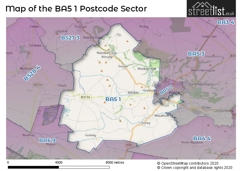
The BA5 1 postcode sector is within the county of Somerset.
Did you know? According to the 2021 Census, the BA5 1 postcode sector is home to a bustling 6,830 residents!
Given that each sector allows for 400 unique postcode combinations. Letters C, I, K, M, O and V are not allowed in the last two letters of a postcode. With 279 postcodes already in use, this leaves 121 units available.
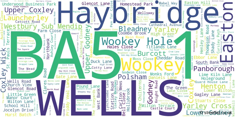
The largest settlement in the BA5 1 postal code is WELLS followed by Wookey, and Westbury Sub Mendip.
The BA5 1 Postcode shares a border with BA4 4 (SHEPTON MALLET, Pilton, Doulting), BA5 2 (WELLS), BA5 3 (WELLS, Croscombe, Priddy), BA6 9 (GLASTONBURY, Meare, Westhay), BS27 3 (CHEDDAR, Draycott, Rodney Stoke) and BS28 4 (WEDMORE, Blackford, Theale).
The sector is within the post town of WELLS.
BA5 1 is a postcode sector within the BA5 postcode district which is within the BA Bath postcode area.
The Royal Mail delivery office for the BA5 1 postal sector is the Wells Delivery Office.
The area of the BA5 1 postcode sector is 23.25 square miles which is 60.23 square kilometres or 14,882.03 square acres.
Waterways within the BA5 1 postcode sector include the River Axe, River Ho, River Steppey.

Map of the BA5 1 Postcode Sector
Explore the BA5 1 postcode sector by using our free interactive map.
| B | A | 5 | - | 1 | X | X |
| B | A | 5 | Space | 1 | Letter | Letter |
Official List of Streets
Wookey (28 Streets)
WELLS (51 Streets)
Easton (13 Streets)
Westbury Sub Mendip (28 Streets)
Bleadney (4 Streets)
Haybridge (9 Streets)
Coxley (16 Streets)
Burcott (3 Streets)
Wookey Hole (12 Streets)
Henton (1 Streets)
Panborough (5 Streets)
Coxley Wick (2 Streets)
Polsham (1 Streets)
Yarley (1 Streets)
Unofficial Streets or Alternative Spellings
WELLS
BIGNAL RAND DRIVE BURCOTT ROAD CHARTER WAY HAMILTONS CLOSE HUDDLESTON COURT LAWPOOL COURT MILL STREET OLD MILL WAY OSMOND DRIVE PENLEIGH ROAD PRINCES ROAD STRAWBERRY WAY TOR STREET WEST STREET WOOKEY HOLE ROADNorth Wootton
BARROW LANE ALFRED COURT ASH MOOR DROVE AUKLAND CLOSE BIDDLE COMBE CLOSE BISHOPS PARK WAY BOURTONBRIDGE DROVE BROADWAY LANE BUTTICE LANE CATHEDERAL AVENUE CHEDDAR VALLEY LINE CLAY PIT LANE CROFT LANE DAGGS LANE DAGGS LANE DROVE DECKLE EDGE CLOSE DEERLEAP DOCTORS HILL DODDRELLS CLOSE DRAKES DROVE DRAPEL LANE DUMMIS LANE EIGHT ACRE DROVE ERLON LANE FELTHAM CLOSE FORD LANE GIPSY LANE GODNEY DROVE GOODY MOOR CLOSE HAYES DRIVE HAYMOOR DROVE HILLERS LANE HURN DROVE KENNEL BATCH KITES CROFT LAUNCHERLEY ROAD LEAZE DROVE LEWISS DROVE LITTLE FIELD LANE LODGE HILL LONG DROVE LOWER CRANNEL DROVE MARCHEY DROVE MONKSFORD LANE MOOR LANE MOOR SHERD MORGANS YARD NIMROD WAY OAKS DROVE ORCHARD PADDOCK PALACE COURT PELTING DROVE PENNY BATCH LANE PILLMOOR DROVE POPLAR FARM PORTIS CLOSE RIVER PADDOCK DROVE RODMEAD LANE SAINT JOHN STREET SAINT JOHNS COURT SHORT DROVE SLOWLAND LANE STONEY STILE WAY SWANSHARD BRIDGE TAYLOR PADDOCK DROVE THE CARLTONS THE CLOISTERS THE DRANG THE GRANGE THE RANK TILLEYS DROVE TOWNHALL BUILDINGS TRIPPS DROVE UNDERWOOD IND. EST. UNDERWOOD ROAD WEBBS CLOSE WESTHAY MOOR DROVE WETMOOR LANE WHITES DROVE WILSON CLOSE WOODFORD ROAD WOOKEY HOLE ROAD WOOLCOMBE ROAD YARLEY FIELD LANE YEAPS BRIDGE YEAPS DROVE YEO MOOR DROVE YET MEAD LANEUpper Milton
TYNINGS LANECoxley
WELLSWAYGLASTONBURY
GODNEY ROAD WELLS ROADBlakeway
NORTH CHINE DROVERodney Stoke
BARROW WOOD LANE WESTFIELD LANEDraycott
WELLS ROADWeather Forecast for BA5 1
Press Button to Show Forecast for Yarley
| Time Period | Icon | Description | Temperature | Rain Probability | Wind |
|---|---|---|---|---|---|
| 00:00 to 03:00 | Light rain | 7.0°C (feels like 4.0°C) | 57.00% | ENE 11 mph | |
| 03:00 to 06:00 | Overcast | 6.0°C (feels like 3.0°C) | 53.00% | ENE 11 mph | |
| 06:00 to 09:00 | Cloudy | 6.0°C (feels like 2.0°C) | 12.00% | ENE 13 mph | |
| 09:00 to 12:00 | Cloudy | 8.0°C (feels like 5.0°C) | 7.00% | ENE 13 mph | |
| 12:00 to 15:00 | Cloudy | 10.0°C (feels like 8.0°C) | 37.00% | NE 11 mph | |
| 15:00 to 18:00 | Cloudy | 11.0°C (feels like 8.0°C) | 10.00% | NE 13 mph | |
| 18:00 to 21:00 | Cloudy | 10.0°C (feels like 7.0°C) | 11.00% | NE 13 mph | |
| 21:00 to 00:00 | Cloudy | 8.0°C (feels like 5.0°C) | 13.00% | NNE 13 mph |
Press Button to Show Forecast for Yarley
| Time Period | Icon | Description | Temperature | Rain Probability | Wind |
|---|---|---|---|---|---|
| 00:00 to 03:00 | Light rain | 7.0°C (feels like 4.0°C) | 47.00% | NNE 13 mph | |
| 03:00 to 06:00 | Heavy rain | 6.0°C (feels like 3.0°C) | 80.00% | N 13 mph | |
| 06:00 to 09:00 | Heavy rain | 6.0°C (feels like 2.0°C) | 80.00% | N 11 mph | |
| 09:00 to 12:00 | Light rain | 8.0°C (feels like 5.0°C) | 52.00% | NNW 11 mph | |
| 12:00 to 15:00 | Overcast | 10.0°C (feels like 7.0°C) | 19.00% | WNW 11 mph | |
| 15:00 to 18:00 | Partly cloudy (day) | 10.0°C (feels like 8.0°C) | 8.00% | W 11 mph | |
| 18:00 to 21:00 | Sunny day | 10.0°C (feels like 8.0°C) | 3.00% | WSW 9 mph | |
| 21:00 to 00:00 | Clear night | 6.0°C (feels like 4.0°C) | 1.00% | WSW 7 mph |
Press Button to Show Forecast for Yarley
| Time Period | Icon | Description | Temperature | Rain Probability | Wind |
|---|---|---|---|---|---|
| 00:00 to 03:00 | Clear night | 4.0°C (feels like 2.0°C) | 0.00% | S 4 mph | |
| 03:00 to 06:00 | Clear night | 4.0°C (feels like 1.0°C) | 1.00% | SSE 7 mph | |
| 06:00 to 09:00 | Partly cloudy (day) | 6.0°C (feels like 3.0°C) | 2.00% | SSE 7 mph | |
| 09:00 to 12:00 | Cloudy | 11.0°C (feels like 9.0°C) | 6.00% | S 13 mph | |
| 12:00 to 15:00 | Cloudy | 13.0°C (feels like 10.0°C) | 7.00% | S 16 mph | |
| 15:00 to 18:00 | Cloudy | 13.0°C (feels like 10.0°C) | 7.00% | S 16 mph | |
| 18:00 to 21:00 | Partly cloudy (day) | 12.0°C (feels like 9.0°C) | 4.00% | S 13 mph | |
| 21:00 to 00:00 | Clear night | 9.0°C (feels like 7.0°C) | 4.00% | SE 11 mph |
Press Button to Show Forecast for Yarley
| Time Period | Icon | Description | Temperature | Rain Probability | Wind |
|---|---|---|---|---|---|
| 00:00 to 03:00 | Partly cloudy (night) | 9.0°C (feels like 6.0°C) | 4.00% | SE 11 mph | |
| 03:00 to 06:00 | Clear night | 9.0°C (feels like 6.0°C) | 5.00% | SE 11 mph | |
| 06:00 to 09:00 | Sunny day | 9.0°C (feels like 6.0°C) | 6.00% | SE 11 mph | |
| 09:00 to 12:00 | Partly cloudy (day) | 13.0°C (feels like 10.0°C) | 10.00% | SE 13 mph | |
| 12:00 to 15:00 | Partly cloudy (day) | 14.0°C (feels like 11.0°C) | 11.00% | SE 16 mph | |
| 15:00 to 18:00 | Cloudy | 15.0°C (feels like 12.0°C) | 31.00% | SE 13 mph | |
| 18:00 to 21:00 | Partly cloudy (day) | 13.0°C (feels like 11.0°C) | 8.00% | SE 9 mph | |
| 21:00 to 00:00 | Clear night | 10.0°C (feels like 9.0°C) | 6.00% | ESE 7 mph |
Schools and Places of Education Within the BA5 1 Postcode Sector
Coxley Primary School
Community school
Harters Hill Lane, Wells, Somerset, BA5 1RD
Head: Mrs Hayley Hamblin
Ofsted Rating: Requires improvement
Inspection: 2023-07-12 (290 days ago)
Website: Visit Coxley Primary School Website
Phone: 01749672719
Number of Pupils: 56
St Cuthbert's Church of England Academy Infants and Pre-School
Academy converter
Keward Walk, Wells, Somerset, BA5 1TZ
Head: Mrs Sheryl Cooper
Ofsted Rating: Good
Inspection: 2023-06-07 (325 days ago)
Website: Visit St Cuthbert's Church of England Academy Infants and Pre-School Website
Phone: 01749672591
Number of Pupils: 187
St Cuthbert's CofE Junior School
Voluntary controlled school
Keward Avenue, Wells, Somerset, BA5 1TS
Head: Mrs Helen Mullinger
Ofsted Rating: Good
Inspection: 2023-09-27 (213 days ago)
Website: Visit St Cuthbert's CofE Junior School Website
Phone: 01749678066
Number of Pupils: 168
St Lawrence's CofE Primary School
Voluntary controlled school
School Hill, Wells, Somerset, BA5 1HL
Head: Mrs Sharon Foxall
Ofsted Rating: Good
Inspection: 2023-03-23 (401 days ago)
Website: Visit St Lawrence's CofE Primary School Website
Phone: 01749870437
Number of Pupils: 43
Wookey Primary School
Community school
Wells Road, Wells, Somerset, BA5 1LQ
Head: Mr Andrew Marsh
Ofsted Rating: Good
Inspection: 2019-09-18 (1683 days ago)
Website: Visit Wookey Primary School Website
Phone: 01749673650
Number of Pupils: 108
House Prices in the BA5 1 Postcode Sector
| Type of Property | 2018 Average | 2018 Sales | 2017 Average | 2017 Sales | 2016 Average | 2016 Sales | 2015 Average | 2015 Sales |
|---|---|---|---|---|---|---|---|---|
| Detached | £428,505 | 59 | £463,289 | 72 | £420,246 | 73 | £383,941 | 72 |
| Semi-Detached | £281,820 | 42 | £264,010 | 34 | £243,177 | 31 | £247,342 | 48 |
| Terraced | £246,309 | 32 | £254,337 | 34 | £259,043 | 32 | £221,737 | 54 |
| Flats | £164,700 | 24 | £138,498 | 29 | £152,256 | 32 | £145,126 | 21 |
Important Postcodes BA5 1 in the Postcode Sector
BA5 1JD is the postcode for Westbury Village Hall, Hannahs Lane, Westbury Sub Mendip
BA5 1LQ is the postcode for Wookey Primary School, Wells Road, Wookey
BA5 1TH is the postcode for Somerset Partnership NHS and Social Care Trust, Phoenix House, St. Andrews, Glastonbury Road, St Andrews Ward, Priory Health Park, Glastonbury Road, and ST ANDREWS COMMUNITY UNIT FOR THE ELDERLY, GLASTONBURY ROAD
BA5 1TJ is the postcode for THE BRIDGE, Priory Hospital, Glastonbury Road
BA5 1TL is the postcode for Avon & Somerset Constabulary, Police Station, 18 Glastonbury Road
BA5 1TS is the postcode for Wells Central Junior School, Keward Avenue
BA5 1TZ is the postcode for St. Cuthberts CE Infants School, Keward Walk, and St Cuthberts C Of E Infants School, Keward Walk
BA5 1XJ is the postcode for Wells Health Centre, Priory Health Park, Glastonbury Road, and WELLS CITY PRACTICE, Priory Medical Centre, Priory Health Park
BA5 1XL is the postcode for GFL SW WING, Priory House, Glastonbury Road, and Priory House, Glastonbury Road
| The BA5 1 Sector is within these Local Authorities |
|
|---|---|
| The BA5 1 Sector is within these Counties |
|
| The BA5 1 Sector is within these Water Company Areas |
|