The BA5 postcode district is a postal district located in the BA Bath postcode area with a population of 19,145 residents according to the 2021 England and Wales Census.
The area of the BA5 postcode district is 50.97 square miles which is 132.00 square kilometres or 32,617.57 acres.
Currently, the BA5 district has about 774 postcode units spread across 3 geographic postcode sectors.
Given that each sector allows for 400 unique postcode combinations, the district has a capacity of 1,200 postcodes. With 774 postcodes already in use, this leaves 426 units available.
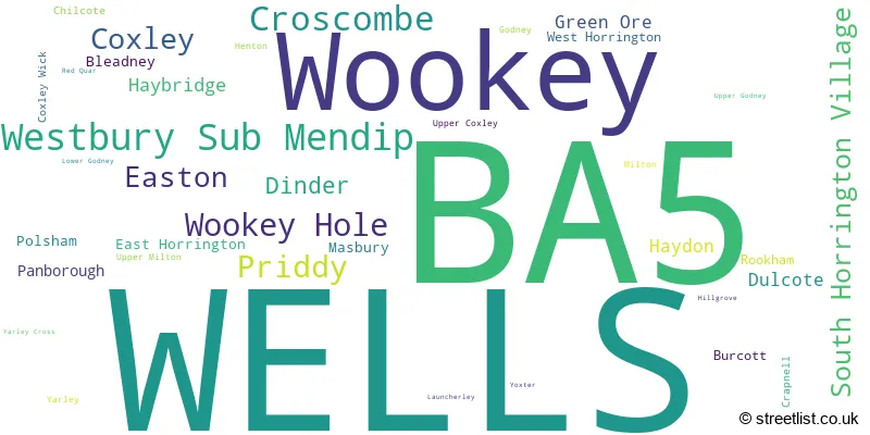
The largest settlement in the BA5 postal code is WELLS followed by Wookey, and Westbury Sub Mendip.
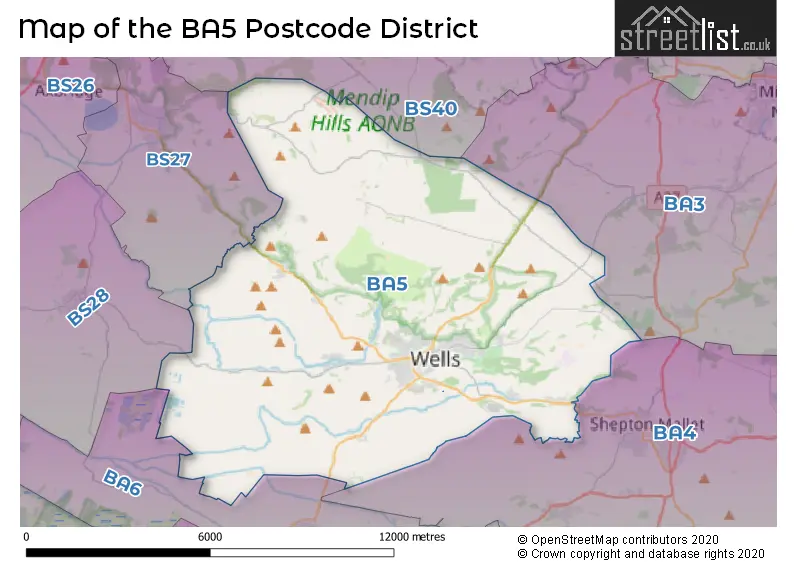
The BA5 Postcode shares a border with BS40 (Wrington, Langford, Winford), BA4 (SHEPTON MALLET, Evercreech, Pilton), BA6 (GLASTONBURY, Baltonsborough, Meare), BS27 (CHEDDAR, Draycott, Rodney Stoke) and BS28 (WEDMORE, Blackford, Theale).
In the BA5 postcode district, the primary settlement is Wells, located in the county of Somerset, England. Other significant settlements in this district include Bleadney, Burcott, Coxley, Coxley Wick, Easton, Godney, Haybridge, Henton, Launcherley, Lower Godney, Panborough, Polsham, Upper Coxley, Upper Godney, Westbury Sub Mendip, Wookey, Wookey Hole, Yarley, and Yarley Cross. Wells serves as the main post town within this district.
For the district BA5, we have data on 4 postcode sectors. Here's a breakdown: The sector BA5 1, covers Wells and Wookey and Westbury Sub Mendip in Somerset. The sector BA5 2, covers Wells in Somerset. The sector BA5 3, covers Wells and Croscombe and Priddy in Somerset. The sector BA5 9 is non-geographic. It's often designated for PO Boxes, large organisations, or special services.

Map of the BA5 Postcode District
Explore the BA5 postcode district by using our free interactive map.
When it comes to local government, postal geography often disregards political borders. However, for a breakdown in the BA5 District: the district mostly encompasses the Somerset area with a total of 787 postcodes.
Weather Forecast for BA5
Press Button to Show Forecast for Milton Lodge
| Time Period | Icon | Description | Temperature | Rain Probability | Wind |
|---|---|---|---|---|---|
| 06:00 to 09:00 | Cloudy | 6.0°C (feels like 2.0°C) | 11.00% | ENE 13 mph | |
| 09:00 to 12:00 | Cloudy | 7.0°C (feels like 4.0°C) | 8.00% | ENE 13 mph | |
| 12:00 to 15:00 | Cloudy | 10.0°C (feels like 7.0°C) | 18.00% | NE 13 mph | |
| 15:00 to 18:00 | Cloudy | 11.0°C (feels like 8.0°C) | 9.00% | NE 11 mph | |
| 18:00 to 21:00 | Cloudy | 9.0°C (feels like 6.0°C) | 12.00% | NE 13 mph | |
| 21:00 to 00:00 | Cloudy | 8.0°C (feels like 4.0°C) | 14.00% | NE 16 mph |
Press Button to Show Forecast for Milton Lodge
| Time Period | Icon | Description | Temperature | Rain Probability | Wind |
|---|---|---|---|---|---|
| 00:00 to 03:00 | Light rain | 7.0°C (feels like 3.0°C) | 46.00% | NNE 16 mph | |
| 03:00 to 06:00 | Heavy rain | 6.0°C (feels like 2.0°C) | 79.00% | N 13 mph | |
| 06:00 to 09:00 | Heavy rain | 6.0°C (feels like 2.0°C) | 78.00% | N 13 mph | |
| 09:00 to 12:00 | Light rain | 7.0°C (feels like 4.0°C) | 51.00% | NNW 11 mph | |
| 12:00 to 15:00 | Overcast | 9.0°C (feels like 7.0°C) | 19.00% | NW 11 mph | |
| 15:00 to 18:00 | Cloudy | 10.0°C (feels like 8.0°C) | 11.00% | WNW 9 mph | |
| 18:00 to 21:00 | Partly cloudy (day) | 10.0°C (feels like 8.0°C) | 4.00% | W 9 mph | |
| 21:00 to 00:00 | Clear night | 6.0°C (feels like 4.0°C) | 1.00% | WSW 7 mph |
Press Button to Show Forecast for Milton Lodge
| Time Period | Icon | Description | Temperature | Rain Probability | Wind |
|---|---|---|---|---|---|
| 00:00 to 03:00 | Clear night | 4.0°C (feels like 2.0°C) | 0.00% | SSW 4 mph | |
| 03:00 to 06:00 | Clear night | 3.0°C (feels like 1.0°C) | 2.00% | S 7 mph | |
| 06:00 to 09:00 | Sunny day | 6.0°C (feels like 3.0°C) | 2.00% | SSE 7 mph | |
| 09:00 to 12:00 | Partly cloudy (day) | 11.0°C (feels like 8.0°C) | 4.00% | S 13 mph | |
| 12:00 to 15:00 | Cloudy | 12.0°C (feels like 9.0°C) | 8.00% | S 16 mph | |
| 15:00 to 18:00 | Cloudy | 12.0°C (feels like 9.0°C) | 8.00% | S 16 mph | |
| 18:00 to 21:00 | Sunny day | 11.0°C (feels like 9.0°C) | 4.00% | S 11 mph | |
| 21:00 to 00:00 | Clear night | 9.0°C (feels like 6.0°C) | 4.00% | SSE 11 mph |
Press Button to Show Forecast for Milton Lodge
| Time Period | Icon | Description | Temperature | Rain Probability | Wind |
|---|---|---|---|---|---|
| 00:00 to 03:00 | Clear night | 8.0°C (feels like 6.0°C) | 4.00% | SE 11 mph | |
| 03:00 to 06:00 | Clear night | 8.0°C (feels like 5.0°C) | 5.00% | SE 11 mph | |
| 06:00 to 09:00 | Sunny day | 8.0°C (feels like 6.0°C) | 7.00% | SE 11 mph | |
| 09:00 to 12:00 | Partly cloudy (day) | 12.0°C (feels like 9.0°C) | 11.00% | SE 13 mph | |
| 12:00 to 15:00 | Partly cloudy (day) | 14.0°C (feels like 11.0°C) | 13.00% | SSE 13 mph | |
| 15:00 to 18:00 | Light rain shower (day) | 14.0°C (feels like 11.0°C) | 36.00% | SSE 13 mph | |
| 18:00 to 21:00 | Partly cloudy (day) | 12.0°C (feels like 11.0°C) | 11.00% | SE 9 mph | |
| 21:00 to 00:00 | Partly cloudy (night) | 9.0°C (feels like 8.0°C) | 7.00% | ESE 7 mph |
Where is the BA5 Postcode District?
The BA5 postcode district is located in Wells, a town in Somerset. It is surrounded by several nearby towns, including Glastonbury to the south, Cheddar to the northwest, Wedmore to the west, Shepton Mallet to the southeast, and Street to the southwest. The distance between the BA5 postcode district and the center of London is approximately 111.8 miles.
The district is within the post town of WELLS.
The sector has postcodes within the nation of England.
The BA5 Postcode District is in the Somerset region of Dorset and Somerset within the South West (England).
| Postcode Sector | Delivery Office |
|---|---|
| BA5 1 | Wells Delivery Office |
| BA5 2 | Wells Delivery Office |
| BA5 3 | Wells Delivery Office |
| B | A | 5 | - | X | X | X |
| B | A | 5 | Space | Numeric | Letter | Letter |
Tourist Attractions within the Postcode Area
We found 1 visitor attractions within the BA5 postcode area
| Wells and Mendip Museum |
|---|
| Museums & Art Galleries |
| Museum and / or Art Gallery |
| View Wells and Mendip Museum on Google Maps |
Current Monthly Rental Prices
| # Bedrooms | Min Price | Max Price | Avg Price |
|---|---|---|---|
| £475 | £475 | £475 | |
| 1 | £750 | £750 | £750 |
| 2 | £850 | £900 | £875 |
| 3 | £925 | £1,100 | £1,007 |
| 5 | £2,000 | £2,000 | £2,000 |
Current House Prices
| # Bedrooms | Min Price | Max Price | Avg Price |
|---|---|---|---|
| 3 | £800,000 | £900,000 | £850,000 |
| 4 | £750,000 | £1,300,000 | £877,000 |
| 5 | £740,000 | £1,250,000 | £937,500 |
| 6 | £1,000,000 | £1,750,000 | £1,316,667 |
| 7 | £1,250,000 | £1,900,000 | £1,591,667 |
| 9 | £1,400,000 | £1,400,000 | £1,400,000 |
| 11 | £1,250,000 | £1,250,000 | £1,250,000 |
Estate Agents who Operate in the BA5 District
| Logo | Name | Brand Name | Address | Contact Number | Total Properties |
|---|---|---|---|---|---|
 | Wells | Cooper & Tanner | 19 Broad Street, Wells, BA5 2DJ | 020 3835 4094 | 47 |
 | Wells | holland & odam | 55 High Street, Wells, BA5 2AE | 020 3856 4159 | 34 |
 | Wells | Palmer Snell | 7-9 Broad Street, Wells, BA5 2DJ | 020 3835 3076 | 22 |
 | Wells | Killens | 10 Sadler Street, Wells, BA5 2SE | 01749 608462 | 20 |
 | Wells | Greenslade Taylor Hunt | 74 High Street, Wells, Somerset, BA5 2AJ | 020 3869 5822 | 16 |
- Binegar
- Bleadney
- Bradley Cross
- Burcott
- Coxley
- Coxley Wick
- Croscombe
- Dinder
- Draycott
- Dulcote
- East Horrington
- Easton
- Green Ore
- Haybridge
- Henton
- Oakhill
- Priddy
- Rodney Stoke
- Shepton Mallet
- South Horrington
- Theale
- Upper Coxley
- Upper Godney
- Wells
- West Horrington
- Westbury-sub-Mendip
- Woodford
- Wookey Hole
- Wookey
- Worth
- Yarley
| Type of Property | 2018 Average | 2018 Sales | 2017 Average | 2017 Sales | 2016 Average | 2016 Sales | 2015 Average | 2015 Sales |
|---|---|---|---|---|---|---|---|---|
| Detached | £438,814 | 138 | £455,063 | 133 | £426,170 | 148 | £398,234 | 127 |
| Semi-Detached | £271,303 | 103 | £263,065 | 130 | £251,354 | 95 | £234,028 | 109 |
| Terraced | £253,410 | 104 | £264,312 | 110 | £257,800 | 110 | £221,826 | 136 |
| Flats | £193,333 | 69 | £161,373 | 68 | £168,698 | 70 | £147,014 | 43 |