The BA4 postcode district is a postal district located in the BA Bath postcode area with a population of 18,468 residents according to the 2021 England and Wales Census.
The area of the BA4 postcode district is 62.13 square miles which is 160.92 square kilometres or 39,764.21 acres.
Currently, the BA4 district has about 829 postcode units spread across 3 geographic postcode sectors.
Given that each sector allows for 400 unique postcode combinations, the district has a capacity of 1,200 postcodes. With 829 postcodes already in use, this leaves 371 units available.
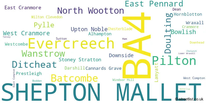
The largest settlement in the BA4 postal code is SHEPTON MALLET followed by Evercreech, and Pilton.
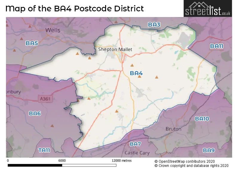
The BA4 Postcode shares a border with BA3 (Midsomer Norton, Westfield, RADSTOCK), BA5 (WELLS, Wookey, Westbury Sub Mendip), BA6 (GLASTONBURY, Baltonsborough, Meare), BA7 (CASTLE CARY, Ansford, Lovington) and BA10 (BRUTON, North Brewham, South Brewham).
The primary settlement in the BA4 postcode district is Shepton Mallet, located in the county of Somerset in England. Other significant settlements in this district include Bodden, Cannards Grave, Chelynch, Chesterblade, Cranmore, Dean, Doulting, Downhead, Downside, East Compton, East Cranmore, Ham, North Wootton, Pilton, Prestleigh, Tansey, Wanstrow, Waterlip, West Compton, West Cranmore, and Windsor Hill. The most significant post town in this district is also Shepton Mallet.
For the district BA4, we have data on 4 postcode sectors. Here's a breakdown: The sector BA4 4, covers Shepton Mallet and Pilton in Somerset. The sector BA4 5, covers Shepton Mallet in Somerset. The sector BA4 6, covers Evercreech and Batcombe and Ditcheat in Somerset. The sector BA4 9 is non-geographic. It's often designated for PO Boxes, large organisations, or special services.

Map of the BA4 Postcode District
Explore the BA4 postcode district by using our free interactive map.
When it comes to local government, postal geography often disregards political borders. However, for a breakdown in the BA4 District: the district mostly encompasses the Somerset area with a total of 833 postcodes.
Weather Forecast for BA4
Press Button to Show Forecast for Royal Bath & West Showground
| Time Period | Icon | Description | Temperature | Rain Probability | Wind |
|---|---|---|---|---|---|
| 09:00 to 12:00 | Cloudy | 8.0°C (feels like 5.0°C) | 10.00% | ENE 11 mph | |
| 12:00 to 15:00 | Cloudy | 10.0°C (feels like 7.0°C) | 46.00% | NE 13 mph | |
| 15:00 to 18:00 | Cloudy | 11.0°C (feels like 8.0°C) | 12.00% | NE 11 mph | |
| 18:00 to 21:00 | Cloudy | 9.0°C (feels like 7.0°C) | 12.00% | NE 13 mph | |
| 21:00 to 00:00 | Cloudy | 8.0°C (feels like 5.0°C) | 15.00% | NNE 13 mph |
Press Button to Show Forecast for Royal Bath & West Showground
| Time Period | Icon | Description | Temperature | Rain Probability | Wind |
|---|---|---|---|---|---|
| 00:00 to 03:00 | Light rain | 7.0°C (feels like 3.0°C) | 56.00% | NNE 13 mph | |
| 03:00 to 06:00 | Heavy rain | 6.0°C (feels like 2.0°C) | 80.00% | N 13 mph | |
| 06:00 to 09:00 | Heavy rain | 6.0°C (feels like 2.0°C) | 81.00% | N 11 mph | |
| 09:00 to 12:00 | Light rain | 7.0°C (feels like 4.0°C) | 58.00% | NNW 11 mph | |
| 12:00 to 15:00 | Overcast | 9.0°C (feels like 6.0°C) | 19.00% | NW 11 mph | |
| 15:00 to 18:00 | Cloudy | 10.0°C (feels like 8.0°C) | 12.00% | WNW 9 mph | |
| 18:00 to 21:00 | Sunny day | 9.0°C (feels like 7.0°C) | 5.00% | WSW 9 mph | |
| 21:00 to 00:00 | Clear night | 6.0°C (feels like 4.0°C) | 1.00% | WSW 7 mph |
Press Button to Show Forecast for Royal Bath & West Showground
| Time Period | Icon | Description | Temperature | Rain Probability | Wind |
|---|---|---|---|---|---|
| 00:00 to 03:00 | Clear night | 4.0°C (feels like 2.0°C) | 1.00% | SW 4 mph | |
| 03:00 to 06:00 | Clear night | 3.0°C (feels like 1.0°C) | 1.00% | S 4 mph | |
| 06:00 to 09:00 | Sunny day | 6.0°C (feels like 3.0°C) | 2.00% | S 7 mph | |
| 09:00 to 12:00 | Partly cloudy (day) | 11.0°C (feels like 8.0°C) | 4.00% | S 13 mph | |
| 12:00 to 15:00 | Cloudy | 12.0°C (feels like 9.0°C) | 8.00% | S 16 mph | |
| 15:00 to 18:00 | Partly cloudy (day) | 12.0°C (feels like 9.0°C) | 5.00% | S 16 mph | |
| 18:00 to 21:00 | Sunny day | 11.0°C (feels like 9.0°C) | 5.00% | S 11 mph | |
| 21:00 to 00:00 | Clear night | 9.0°C (feels like 6.0°C) | 5.00% | SSE 11 mph |
Press Button to Show Forecast for Royal Bath & West Showground
| Time Period | Icon | Description | Temperature | Rain Probability | Wind |
|---|---|---|---|---|---|
| 00:00 to 03:00 | Clear night | 8.0°C (feels like 6.0°C) | 4.00% | SE 11 mph | |
| 03:00 to 06:00 | Clear night | 8.0°C (feels like 5.0°C) | 5.00% | SE 11 mph | |
| 06:00 to 09:00 | Sunny day | 8.0°C (feels like 6.0°C) | 7.00% | SE 11 mph | |
| 09:00 to 12:00 | Partly cloudy (day) | 12.0°C (feels like 9.0°C) | 12.00% | SE 13 mph | |
| 12:00 to 15:00 | Cloudy | 14.0°C (feels like 11.0°C) | 17.00% | SSE 13 mph | |
| 15:00 to 18:00 | Light rain shower (day) | 14.0°C (feels like 11.0°C) | 35.00% | SSE 13 mph | |
| 18:00 to 21:00 | Cloudy | 13.0°C (feels like 11.0°C) | 15.00% | SE 9 mph | |
| 21:00 to 00:00 | Clear night | 9.0°C (feels like 8.0°C) | 8.00% | SE 7 mph |
Where is the BA4 Postcode District?
The postcode district BA4 is located in the town of Shepton Mallet. Shepton Mallet is near several other towns, including Wells to the north-west (3.19 miles away), Bruton to the south-east (4.82 miles away), Castle Cary to the south (5.25 miles away), Glastonbury to the west (8.46 miles away), Frome to the north-east (9.30 miles away), and Radstock to the north (9.53 miles away). Additionally, Shepton Mallet is approximately 106.42 miles away from the center of London.
The district is within the post town of SHEPTON MALLET.
The sector has postcodes within the nation of England.
The BA4 Postcode District is in the Somerset region of Dorset and Somerset within the South West (England).
| Postcode Sector | Delivery Office |
|---|---|
| BA4 4 | Shepton Mallet Delivery Office |
| BA4 5 | Shepton Mallet Delivery Office |
| BA4 6 | Shepton Mallet Delivery Office |
| B | A | 4 | - | X | X | X |
| B | A | 4 | Space | Numeric | Letter | Letter |
Tourist Attractions within the Postcode Area
We found 1 visitor attractions within the BA4 postcode area
| East Somerset Railway |
|---|
| Railways |
| Steam / Heritage Railway |
| View East Somerset Railway on Google Maps |
Current Monthly Rental Prices
| # Bedrooms | Min Price | Max Price | Avg Price |
|---|---|---|---|
| 1 | £525 | £1,250 | £790 |
| 2 | £800 | £895 | £848 |
| 3 | £950 | £1,300 | £1,206 |
| 4 | £1,800 | £3,200 | £2,500 |
| 5 | £1,300 | £1,300 | £1,300 |
| 6 | £3,500 | £3,500 | £3,500 |
Current House Prices
| # Bedrooms | Min Price | Max Price | Avg Price |
|---|---|---|---|
| £750,000 | £750,000 | £750,000 | |
| 3 | £269,950 | £925,000 | £581,990 |
| 4 | £665,000 | £1,395,000 | £974,869 |
| 5 | £675,000 | £1,200,000 | £885,556 |
| 6 | £650,000 | £1,350,000 | £1,066,667 |
| 7 | £1,500,000 | £1,500,000 | £1,500,000 |
Estate Agents who Operate in the BA4 District
| Logo | Name | Brand Name | Address | Contact Number | Total Properties |
|---|---|---|---|---|---|
 | Shepton Mallet | Cooper & Tanner | 32 High Street, Shepton Mallet, BA4 5AS | 01749 608295 | 41 |
 | Shepton Mallet | Stonebridge | 33 High Street, Shepton Mallet, BA4 5AQ | 020 3835 4618 | 33 |
 | Wells | Roderick Thomas | 1 Priory Road Wells BA5 1SR | 020 3834 7879 | 8 |
 | Bruton | Hunter French | 9 High Street, Bruton, BA10 0AB | 01749 608422 | 8 |
 | Downend | Escape & Discover | 15 Sedgefield Gardens, Downend, Bristol, BS16 6SU | 01225 434940 | 7 |
- Alhampton
- Batcombe
- Bodden
- Cannard's Grave
- Chelynch
- Chesterblade
- Cranmore
- Dean
- Dinder
- Ditcheat
- Doulting
- Downhead
- Downside
- Easton Town
- Evercreech
- Huxham Green
- Lamyatt
- Leigh upon Mendip
- Leighton
- Lower Westholme
- Lydford Fair Place
- Milton Clevedon
- North Town
- North Wootton
- Oakhill
- Parbrook
- Pecking Mill
- Pilton
- Prestleigh
- Pylle
- Shepton Mallet
- Sticklynch
- Stoke St Michael
- Stoney Stratton
- Street on the Fosse
- Sutton
- Upper Westholme
- Upton Noble
- Wanstrow
- Waterlip
- West Compton
- Westcombe
- Weston Town
- Wraxall
- Wyke Champflower
| Type of Property | 2018 Average | 2018 Sales | 2017 Average | 2017 Sales | 2016 Average | 2016 Sales | 2015 Average | 2015 Sales |
|---|---|---|---|---|---|---|---|---|
| Detached | £411,005 | 105 | £358,694 | 112 | £367,697 | 98 | £329,911 | 127 |
| Semi-Detached | £239,251 | 73 | £232,506 | 102 | £218,803 | 103 | £188,699 | 86 |
| Terraced | £198,919 | 88 | £187,978 | 102 | £183,897 | 116 | £175,221 | 135 |
| Flats | £129,182 | 38 | £126,235 | 31 | £105,565 | 27 | £112,653 | 45 |