The BA4 4 postcode sector is within the county of Somerset.
Did you know? According to the 2021 Census, the BA4 4 postcode sector is home to a bustling 5,367 residents!
Given that each sector allows for 400 unique postcode combinations. Letters C, I, K, M, O and V are not allowed in the last two letters of a postcode. With 269 postcodes already in use, this leaves 131 units available.
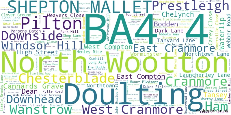
The largest settlement in the BA4 4 postal code is SHEPTON MALLET followed by Pilton, and Doulting.
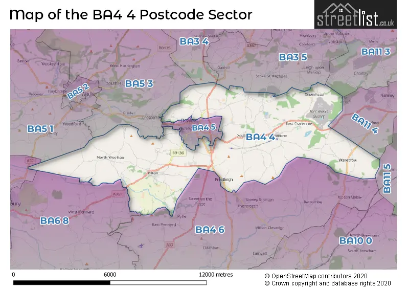
The BA4 4 Postcode shares a border with BA3 4 (Chilcompton, Westfield, Midsomer Norton), BA3 5 (Coleford, Holcombe, Oakhill), BA4 5 (SHEPTON MALLET, Bowlish), BA4 6 (Evercreech, Ditcheat, East Pennard), BA5 1 (WELLS, Wookey, Westbury Sub Mendip), BA11 5 (FROME, Witham Friary, Trudoxhill), BA11 3 (FROME, Mells, Chantry), BA5 3 (WELLS, Croscombe, Priddy), BA6 8 (GLASTONBURY, Baltonsborough, Butleigh), BA6 9 (GLASTONBURY, Meare, Westhay) and BA11 4 (FROME, Nunney, Marston Trading Estate).
The sector is within the post town of SHEPTON MALLET.
BA4 4 is a postcode sector within the BA4 postcode district which is within the BA Bath postcode area.
The Royal Mail delivery office for the BA4 4 postal sector is the Shepton Mallet Delivery Office.
The area of the BA4 4 postcode sector is 31.84 square miles which is 82.46 square kilometres or 20,376.71 square acres.

Map of the BA4 4 Postcode Sector
Explore the BA4 4 postcode sector by using our free interactive map.
| B | A | 4 | - | 4 | X | X |
| B | A | 4 | Space | 4 | Letter | Letter |
Official List of Streets
SHEPTON MALLET (56 Streets)
Pilton (36 Streets)
Downside (4 Streets)
North Wootton (13 Streets)
Doulting (12 Streets)
Cannards Grave (2 Streets)
Wanstrow (13 Streets)
Dean (2 Streets)
East Compton (1 Streets)
West Cranmore (5 Streets)
Prestleigh (2 Streets)
Windsor Hill (2 Streets)
Cranmore (4 Streets)
Ham (2 Streets)
East Cranmore (2 Streets)
Unofficial Streets or Alternative Spellings
Cloford
LONG LANEEvercreech
MAESDOWN HILL PRESTLEIGH ROADSHEPTON MALLET
BISHOP CRESCENT COMPTON ROAD MIDDLETON LANE NIGHTINGALE GROVE WHITSTONE RISE WHITSTONE ROADBowlish
FORUM LANEMasbury
OLD FROME ROADCroscombe
LONG STREET OLD WELLS ROADGLASTONBURY
WELLS ROADWeather Forecast for BA4 4
Press Button to Show Forecast for Royal Bath & West Showground
| Time Period | Icon | Description | Temperature | Rain Probability | Wind |
|---|---|---|---|---|---|
| 09:00 to 12:00 | Cloudy | 8.0°C (feels like 5.0°C) | 10.00% | ENE 11 mph | |
| 12:00 to 15:00 | Cloudy | 10.0°C (feels like 7.0°C) | 46.00% | NE 13 mph | |
| 15:00 to 18:00 | Cloudy | 11.0°C (feels like 8.0°C) | 12.00% | NE 11 mph | |
| 18:00 to 21:00 | Cloudy | 9.0°C (feels like 7.0°C) | 12.00% | NE 13 mph | |
| 21:00 to 00:00 | Cloudy | 8.0°C (feels like 5.0°C) | 15.00% | NNE 13 mph |
Press Button to Show Forecast for Royal Bath & West Showground
| Time Period | Icon | Description | Temperature | Rain Probability | Wind |
|---|---|---|---|---|---|
| 00:00 to 03:00 | Light rain | 7.0°C (feels like 3.0°C) | 56.00% | NNE 13 mph | |
| 03:00 to 06:00 | Heavy rain | 6.0°C (feels like 2.0°C) | 80.00% | N 13 mph | |
| 06:00 to 09:00 | Heavy rain | 6.0°C (feels like 2.0°C) | 81.00% | N 11 mph | |
| 09:00 to 12:00 | Light rain | 7.0°C (feels like 4.0°C) | 58.00% | NNW 11 mph | |
| 12:00 to 15:00 | Overcast | 9.0°C (feels like 6.0°C) | 19.00% | NW 11 mph | |
| 15:00 to 18:00 | Cloudy | 10.0°C (feels like 8.0°C) | 12.00% | WNW 9 mph | |
| 18:00 to 21:00 | Sunny day | 9.0°C (feels like 7.0°C) | 5.00% | WSW 9 mph | |
| 21:00 to 00:00 | Clear night | 6.0°C (feels like 4.0°C) | 1.00% | WSW 7 mph |
Press Button to Show Forecast for Royal Bath & West Showground
| Time Period | Icon | Description | Temperature | Rain Probability | Wind |
|---|---|---|---|---|---|
| 00:00 to 03:00 | Clear night | 4.0°C (feels like 2.0°C) | 1.00% | SW 4 mph | |
| 03:00 to 06:00 | Clear night | 3.0°C (feels like 1.0°C) | 1.00% | S 4 mph | |
| 06:00 to 09:00 | Sunny day | 6.0°C (feels like 3.0°C) | 2.00% | S 7 mph | |
| 09:00 to 12:00 | Partly cloudy (day) | 11.0°C (feels like 8.0°C) | 4.00% | S 13 mph | |
| 12:00 to 15:00 | Cloudy | 12.0°C (feels like 9.0°C) | 8.00% | S 16 mph | |
| 15:00 to 18:00 | Partly cloudy (day) | 12.0°C (feels like 9.0°C) | 5.00% | S 16 mph | |
| 18:00 to 21:00 | Sunny day | 11.0°C (feels like 9.0°C) | 5.00% | S 11 mph | |
| 21:00 to 00:00 | Clear night | 9.0°C (feels like 6.0°C) | 5.00% | SSE 11 mph |
Press Button to Show Forecast for Royal Bath & West Showground
| Time Period | Icon | Description | Temperature | Rain Probability | Wind |
|---|---|---|---|---|---|
| 00:00 to 03:00 | Clear night | 8.0°C (feels like 6.0°C) | 4.00% | SE 11 mph | |
| 03:00 to 06:00 | Clear night | 8.0°C (feels like 5.0°C) | 5.00% | SE 11 mph | |
| 06:00 to 09:00 | Sunny day | 8.0°C (feels like 6.0°C) | 7.00% | SE 11 mph | |
| 09:00 to 12:00 | Partly cloudy (day) | 12.0°C (feels like 9.0°C) | 12.00% | SE 13 mph | |
| 12:00 to 15:00 | Cloudy | 14.0°C (feels like 11.0°C) | 17.00% | SSE 13 mph | |
| 15:00 to 18:00 | Light rain shower (day) | 14.0°C (feels like 11.0°C) | 35.00% | SSE 13 mph | |
| 18:00 to 21:00 | Cloudy | 13.0°C (feels like 11.0°C) | 15.00% | SE 9 mph | |
| 21:00 to 00:00 | Clear night | 9.0°C (feels like 8.0°C) | 8.00% | SE 7 mph |
Schools and Places of Education Within the BA4 4 Postcode Sector
The Mendip School
Free schools special
Edmund Rack Road, Shepton Mallet, Somerset, BA4 4FZ
Head: Mrs Natalie Hanna
Ofsted Rating: Good
Inspection: 2023-10-05 (205 days ago)
Website: Visit The Mendip School Website
Phone: 01749838040
Number of Pupils: 160
House Prices in the BA4 4 Postcode Sector
| Type of Property | 2018 Average | 2018 Sales | 2017 Average | 2017 Sales | 2016 Average | 2016 Sales | 2015 Average | 2015 Sales |
|---|---|---|---|---|---|---|---|---|
| Detached | £427,347 | 51 | £347,607 | 37 | £402,211 | 33 | £326,883 | 65 |
| Semi-Detached | £208,474 | 19 | £248,429 | 31 | £240,233 | 29 | £220,919 | 21 |
| Terraced | £218,577 | 26 | £190,423 | 26 | £179,634 | 31 | £182,590 | 39 |
| Flats | £135,772 | 9 | £141,828 | 9 | £128,786 | 7 | £141,064 | 14 |
Important Postcodes BA4 4 in the Postcode Sector
BA4 4FZ is the postcode for The Mendip School, Edmund Rack Road
BA4 4LP is the postcode for Practice Plus Group Hospital, Shepton Mallet, Old Wells Road, and Shepton Mallet Treatment Centre, Old Wells Road
BA4 4PG is the postcode for Shepton Mallet Community Hospital, St Peters Road, Shepton Mallet Community Hospital, Old Wells Road, and TREATMENT CENTRE, Shepton Mallet Community Hospital, Old Wells Road
BA4 4PL is the postcode for BLOCK A, St. Aldhelms VC Primary School, Chelynch Park
| The BA4 4 Sector is within these Local Authorities |
|
|---|---|
| The BA4 4 Sector is within these Counties |
|
| The BA4 4 Sector is within these Water Company Areas |
|
Tourist Attractions within the BA4 4 Postcode Area
We found 1 visitor attractions within the BA4 postcode area
| East Somerset Railway |
|---|
| Railways |
| Steam / Heritage Railway |
| View East Somerset Railway on Google Maps |