The BA6 postcode district is a postal district located in the BA Bath postcode area with a population of 13,323 residents according to the 2021 England and Wales Census.
The area of the BA6 postcode district is 35.72 square miles which is 92.51 square kilometres or 22,859.31 acres.
Currently, the BA6 district has about 550 postcode units spread across 2 geographic postcode sectors.
Given that each sector allows for 400 unique postcode combinations, the district has a capacity of 800 postcodes. With 550 postcodes already in use, this leaves 250 units available.
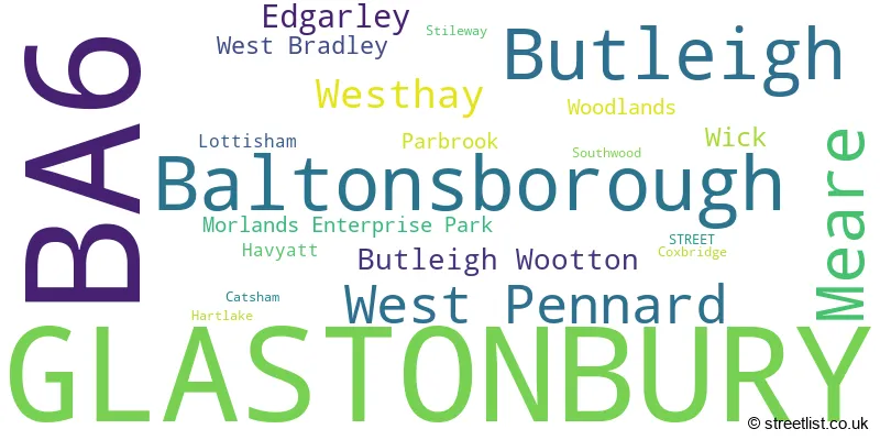
The largest settlement in the BA6 postal code is GLASTONBURY followed by Baltonsborough, and Meare.
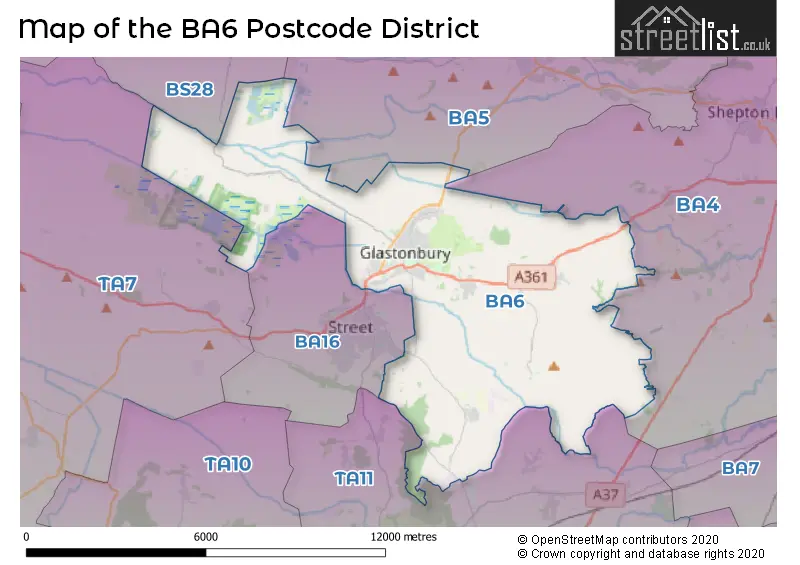
The BA6 Postcode shares a border with TA11 (SOMERTON, Keinton Mandeville, Compton Dundon), BA16 (STREET, Walton, Sharpham), TA7 (Woolavington, Puriton, Westonzoyland), BA4 (SHEPTON MALLET, Evercreech, Pilton), BA5 (WELLS, Wookey, Westbury Sub Mendip) and BS28 (WEDMORE, Blackford, Theale).
In the BA6 postcode district, the primary settlement is Glastonbury, located in the county of Somerset, England. Other significant settlements in the district include Baltonsborough, Butleigh, Butleigh Wootton, Edgarley, West Pennard, and Meare. The post town associated with this district is Glastonbury. Glastonbury has the highest count of postcodes in this district.
For the district BA6, we have data on 3 postcode sectors. Here's a breakdown: The sector BA6 0 is non-geographic. It's often designated for PO Boxes, large organisations, or special services. The sector BA6 8, covers Glastonbury and Baltonsborough and Butleigh in Somerset. The sector BA6 9, covers Glastonbury and Meare in Somerset.

Map of the BA6 Postcode District
Explore the BA6 postcode district by using our free interactive map.
When it comes to local government, postal geography often disregards political borders. However, for a breakdown in the BA6 District: the district mostly encompasses the Somerset area with a total of 554 postcodes.
Where is the BA6 Postcode District?
The postcode district BA6 is located in Glastonbury, a district town. It is near several towns in different directions. Street is located to the South West, approximately 2.1 miles away. Somerton is to the South, about 6.1 miles away. Wells is to the North East, approximately 6.9 miles away. Wedmore is to the North West, around 7.1 miles away. Shepton Mallet is to the East, about 7.4 miles away. Castle Cary is to the South East, approximately 8.5 miles away. Cheddar is located to the North, around 10.1 miles away. Additionally, the postcode district's distance to London is about 114.3 miles.
The district covers the post towns of GLASTONBURY, STREET.
The sector has postcodes within the nation of England.
The BA6 Postcode District is in the Somerset region of Dorset and Somerset within the South West (England).
Weather Forecast for BA6
Press Button to Show Forecast for Glastonbury
| Time Period | Icon | Description | Temperature | Rain Probability | Wind |
|---|---|---|---|---|---|
| 03:00 to 06:00 | Overcast | 13.0°C (feels like 12.0°C) | 12.00% | S 9 mph | |
| 06:00 to 09:00 | Overcast | 13.0°C (feels like 11.0°C) | 9.00% | SSE 11 mph | |
| 09:00 to 12:00 | Cloudy | 15.0°C (feels like 12.0°C) | 46.00% | SSE 18 mph | |
| 12:00 to 15:00 | Heavy rain | 15.0°C (feels like 12.0°C) | 86.00% | SSE 18 mph | |
| 15:00 to 18:00 | Heavy rain | 14.0°C (feels like 11.0°C) | 94.00% | SSE 18 mph | |
| 18:00 to 21:00 | Heavy rain | 14.0°C (feels like 12.0°C) | 95.00% | SSE 13 mph | |
| 21:00 to 00:00 | Heavy rain | 13.0°C (feels like 12.0°C) | 93.00% | SSE 7 mph |
Press Button to Show Forecast for Glastonbury
| Time Period | Icon | Description | Temperature | Rain Probability | Wind |
|---|---|---|---|---|---|
| 00:00 to 03:00 | Light rain | 12.0°C (feels like 11.0°C) | 81.00% | SE 7 mph | |
| 03:00 to 06:00 | Cloudy | 12.0°C (feels like 11.0°C) | 6.00% | SE 7 mph | |
| 06:00 to 09:00 | Cloudy | 12.0°C (feels like 10.0°C) | 5.00% | SE 9 mph | |
| 09:00 to 12:00 | Cloudy | 14.0°C (feels like 11.0°C) | 10.00% | SSE 13 mph | |
| 12:00 to 15:00 | Light rain | 15.0°C (feels like 12.0°C) | 51.00% | SSE 18 mph | |
| 15:00 to 18:00 | Cloudy | 16.0°C (feels like 13.0°C) | 36.00% | SSE 16 mph | |
| 18:00 to 21:00 | Cloudy | 15.0°C (feels like 13.0°C) | 10.00% | SSE 13 mph | |
| 21:00 to 00:00 | Cloudy | 13.0°C (feels like 11.0°C) | 4.00% | SE 11 mph |
Press Button to Show Forecast for Glastonbury
| Time Period | Icon | Description | Temperature | Rain Probability | Wind |
|---|---|---|---|---|---|
| 00:00 to 03:00 | Cloudy | 12.0°C (feels like 10.0°C) | 4.00% | SE 9 mph | |
| 03:00 to 06:00 | Cloudy | 11.0°C (feels like 10.0°C) | 6.00% | SE 9 mph | |
| 06:00 to 09:00 | Partly cloudy (day) | 12.0°C (feels like 10.0°C) | 4.00% | ESE 11 mph | |
| 09:00 to 12:00 | Cloudy | 15.0°C (feels like 12.0°C) | 12.00% | SE 13 mph | |
| 12:00 to 15:00 | Partly cloudy (day) | 16.0°C (feels like 14.0°C) | 11.00% | SE 13 mph | |
| 15:00 to 18:00 | Light rain shower (day) | 16.0°C (feels like 14.0°C) | 31.00% | SE 13 mph | |
| 18:00 to 21:00 | Sunny day | 16.0°C (feels like 14.0°C) | 9.00% | SE 9 mph | |
| 21:00 to 00:00 | Clear night | 12.0°C (feels like 11.0°C) | 0.00% | ESE 7 mph |
Press Button to Show Forecast for Glastonbury
| Time Period | Icon | Description | Temperature | Rain Probability | Wind |
|---|---|---|---|---|---|
| 00:00 to 03:00 | Clear night | 10.0°C (feels like 9.0°C) | 0.00% | ESE 7 mph | |
| 03:00 to 06:00 | Clear night | 9.0°C (feels like 8.0°C) | 1.00% | E 4 mph | |
| 06:00 to 09:00 | Partly cloudy (day) | 11.0°C (feels like 10.0°C) | 2.00% | E 4 mph | |
| 09:00 to 12:00 | Cloudy | 16.0°C (feels like 15.0°C) | 12.00% | SE 7 mph | |
| 12:00 to 15:00 | Cloudy | 18.0°C (feels like 17.0°C) | 17.00% | SE 7 mph | |
| 15:00 to 18:00 | Light rain shower (day) | 16.0°C (feels like 16.0°C) | 33.00% | WSW 4 mph | |
| 18:00 to 21:00 | Partly cloudy (day) | 16.0°C (feels like 16.0°C) | 9.00% | WSW 4 mph | |
| 21:00 to 00:00 | Cloudy | 12.0°C (feels like 11.0°C) | 4.00% | WSW 4 mph |
Press Button to Show Forecast for Glastonbury
| Time Period | Icon | Description | Temperature | Rain Probability | Wind |
|---|---|---|---|---|---|
| 00:00 to 03:00 | Partly cloudy (night) | 11.0°C (feels like 10.0°C) | 4.00% | WSW 4 mph | |
| 03:00 to 06:00 | Partly cloudy (night) | 11.0°C (feels like 10.0°C) | 4.00% | W 4 mph | |
| 06:00 to 09:00 | Cloudy | 12.0°C (feels like 12.0°C) | 8.00% | W 4 mph | |
| 09:00 to 12:00 | Partly cloudy (day) | 16.0°C (feels like 15.0°C) | 6.00% | WNW 7 mph | |
| 12:00 to 15:00 | Light rain shower (day) | 18.0°C (feels like 17.0°C) | 37.00% | WNW 7 mph | |
| 15:00 to 18:00 | Light rain shower (day) | 17.0°C (feels like 16.0°C) | 36.00% | WNW 9 mph | |
| 18:00 to 21:00 | Light rain shower (day) | 17.0°C (feels like 16.0°C) | 32.00% | NW 7 mph | |
| 21:00 to 00:00 | Partly cloudy (night) | 13.0°C (feels like 12.0°C) | 7.00% | NW 7 mph |
| Postcode Sector | Delivery Office |
|---|---|
| BA6 8 | Glastonbury Delivery Office |
| BA6 9 | Glastonbury Delivery Office |
| B | A | 6 | - | X | X | X |
| B | A | 6 | Space | Numeric | Letter | Letter |
Current Monthly Rental Prices
| # Bedrooms | Min Price | Max Price | Avg Price |
|---|---|---|---|
| 1 | £765 | £765 | £765 |
| 2 | £895 | £995 | £945 |
| 3 | £1,400 | £1,400 | £1,400 |
| 4 | £1,650 | £2,600 | £2,125 |
Current House Prices
| # Bedrooms | Min Price | Max Price | Avg Price |
|---|---|---|---|
| £4,500,000 | £5,000,000 | £4,750,000 | |
| 2 | £262,500 | £262,500 | £262,500 |
| 3 | £850,000 | £850,000 | £850,000 |
| 4 | £600,000 | £825,000 | £678,571 |
| 5 | £599,950 | £1,100,000 | £857,217 |
| 6 | £1,000,000 | £2,150,000 | £1,441,667 |
| 7 | £800,000 | £800,000 | £800,000 |
| 8 | £1,500,000 | £1,500,000 | £1,500,000 |
| 9 | £1,550,000 | £1,550,000 | £1,550,000 |
Estate Agents who Operate in the BA6 District
| Logo | Name | Brand Name | Address | Contact Number | Total Properties |
|---|---|---|---|---|---|
 | Glastonbury | holland & odam | 30 High Street, Glastonbury, BA6 9DX | 01458 552277 | 40 |
 | Glastonbury | Cooper & Tanner | 41 High Street, Glastonbury, BA6 9DS | 01458 552262 | 34 |
 | Glastonbury | Tor Estates | 20 High Street, Glastonbury, BA6 9DU | 01458 552280 | 14 |
 | Wells | Greenslade Taylor Hunt | 74 High Street, Wells, Somerset, BA5 2AJ | 020 3869 5822 | 7 |
 | covering Bath | Purplebricks | Suite 7 First Floor Cranmore Drive Shirley Solihull B90 4RZ | 024 7542 0694 | 6 |
Yearly House Price Averages for the BA6 Postcode District
| Type of Property | 2018 Average | 2018 Sales | 2017 Average | 2017 Sales | 2016 Average | 2016 Sales | 2015 Average | 2015 Sales |
|---|---|---|---|---|---|---|---|---|
| Detached | £384,307 | 107 | £412,831 | 90 | £377,743 | 136 | £317,307 | 110 |
| Semi-Detached | £234,636 | 40 | £236,917 | 67 | £229,917 | 55 | £221,184 | 40 |
| Terraced | £230,177 | 70 | £211,470 | 86 | £210,677 | 85 | £173,676 | 100 |
| Flats | £122,050 | 23 | £120,123 | 32 | £126,352 | 41 | £126,235 | 31 |