
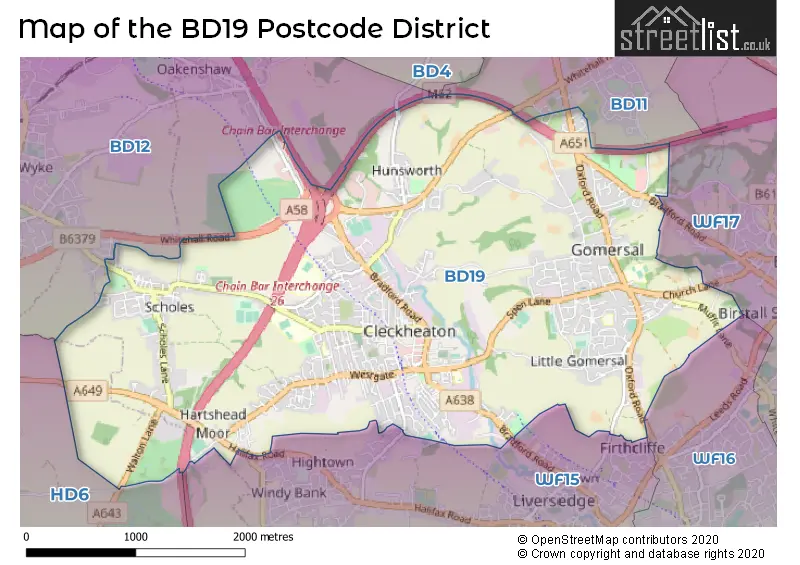
Map of the Postcode District
Explore the postcode district by using our interactive map.
Circles represent recorded crime; the larger the circle, the higher the crime rates.
Your support helps keep this site running!
If you enjoy using this website, consider buying me a coffee to help cover hosting costs.
The postcode district located in the BD Bradford postal area , BD19 has a population of 22,589 residents according to the 2021 England and Wales Census.
The area of the district is 5.50 square miles (14.23 square kilometers or 3,517.06 acres).
Where is the BD19 District?
To give you an idea where the district is located we have created the following table showing nearby towns.
Nearest Towns to BD19
| Town | Distance (miles) | Direction |
|---|---|---|
| Liversedge | 1.45 | SSE |
| Heckmondwike | 2.28 | SE |
| Brighouse | 3.38 | WSW |
| Batley | 3.52 | ESE |
| Mirfield | 3.87 | SSE |
| Dewsbury | 4.45 | SE |
| Bradford | 4.55 | NNW |
| Morley | 4.87 | ENE |
| Pudsey | 5.16 | NNE |
| Elland | 5.82 | WSW |
| Halifax | 5.93 | W |
| Huddersfield | 6.46 | SSW |
| Ossett | 6.51 | ESE |
| Shipley | 7.69 | NNW |
| Horbury | 8.10 | SE |
| Leeds | 8.41 | NE |
| Baildon | 8.85 | NNW |
| Sowerby Bridge | 9.23 | W |
| Wakefield | 9.47 | ESE |
The post town for this district is CLECKHEATON.
Postcode Information for District BD19 (Total Geographical Postcodes: 786)
| Location | Post Town | Sector | Number of Postcodes |
|---|---|---|---|
| CLECKHEATON | CLECKHEATON | BD19 3 | 204 |
| Gomersal | CLECKHEATON | BD19 4 | 198 |
| CLECKHEATON | CLECKHEATON | BD19 5 | 104 |
| Scholes | CLECKHEATON | BD19 6 | 92 |
| CLECKHEATON | CLECKHEATON | BD19 4 | 71 |
| CLECKHEATON | CLECKHEATON | BD19 6 | 66 |
| Rawfolds | CLECKHEATON | BD19 5 | 21 |
| West 26 Industrial Estate | CLECKHEATON | BD19 4 | 8 |
| Moorside | CLECKHEATON | BD19 6 | 6 |
| Marsh | CLECKHEATON | BD19 5 | 5 |
| Chain Bar | CLECKHEATON | BD19 6 | 4 |
| Westgate | CLECKHEATON | BD19 5 | 4 |
| Hunsworth | CLECKHEATON | BD19 4 | 2 |
| Whitcliffe | CLECKHEATON | BD19 3 | 1 |
Retail and Shopping in BD19
Street
Town
Locality
Number of Shops
Central Postcode
View on Google Maps
BRADFORD ROAD
CLECKHEATON
39
BD19 3PT
View on Google Maps
NORTHGATE
CLECKHEATON
39
BD19 5AE
View on Google Maps
WESTGATE
CLECKHEATON
27
BD19 5EY
View on Google Maps
ALBION STREET
CLECKHEATON
26
BD19 3JD
View on Google Maps
OXFORD ROAD
CLECKHEATON
GOMERSAL
19
BD19 4PY
View on Google Maps
CHEAPSIDE
CLECKHEATON
14
BD19 5AF
View on Google Maps
WESTFIELD LANE
CLECKHEATON
SCHOLES
12
BD19 6DA
View on Google Maps
MARKET STREET
CLECKHEATON
11
BD19 5AJ
View on Google Maps
DEWSBURY ROAD
CLECKHEATON
9
BD19 3RS
View on Google Maps
CENTRAL PARADE
CLECKHEATON
8
BD19 3RU
View on Google Maps
CENTRAL ARCADE
CLECKHEATON
7
BD19 5DN
View on Google Maps
| Street | Town | Locality | Number of Shops | Central Postcode | View on Google Maps |
|---|---|---|---|---|---|
| BRADFORD ROAD | CLECKHEATON | 39 | BD19 3PT | View on Google Maps | |
| NORTHGATE | CLECKHEATON | 39 | BD19 5AE | View on Google Maps | |
| WESTGATE | CLECKHEATON | 27 | BD19 5EY | View on Google Maps | |
| ALBION STREET | CLECKHEATON | 26 | BD19 3JD | View on Google Maps | |
| OXFORD ROAD | CLECKHEATON | GOMERSAL | 19 | BD19 4PY | View on Google Maps |
| CHEAPSIDE | CLECKHEATON | 14 | BD19 5AF | View on Google Maps | |
| WESTFIELD LANE | CLECKHEATON | SCHOLES | 12 | BD19 6DA | View on Google Maps |
| MARKET STREET | CLECKHEATON | 11 | BD19 5AJ | View on Google Maps | |
| DEWSBURY ROAD | CLECKHEATON | 9 | BD19 3RS | View on Google Maps | |
| CENTRAL PARADE | CLECKHEATON | 8 | BD19 3RU | View on Google Maps | |
| CENTRAL ARCADE | CLECKHEATON | 7 | BD19 5DN | View on Google Maps |
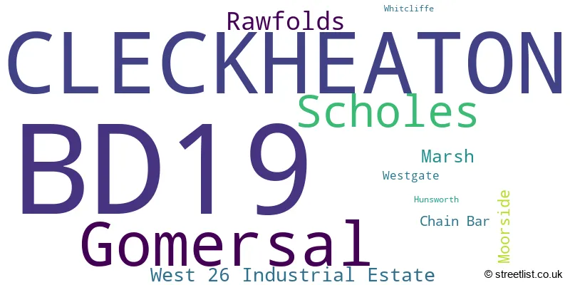
In the BD19 postcode district in West Yorkshire, the primary settlement is Cleckheaton. Other significant settlements in this district include Gomersal, Scholes, and Whitcliffe. The county is referred to as the county of West Yorkshire. The post town for this district is Cleckheaton, which has the highest number of postcodes.
When it comes to local government, postal geography often disregards political borders. However, this district intersects the following councils: the district mostly encompasses the Kirklees District (B) area with a total of 697 postal codes.
The largest settlement in the BD19 postal code is CLECKHEATON followed by Gomersal, and Scholes.
The BD19 Postcode shares a border with WF15 (LIVERSEDGE, Hartshead), WF17 (BATLEY, Birstall, Soothill), HD6 (BRIGHOUSE, Bailiff Bridge, Clifton), BD11 (Drighlington, Birkenshaw) and BD12 (Wyke, Low Moor, Oakenshaw).


Schools in the Sector
Heaton Avenue, A Share Primary Academy
Phase: Primary
Address: South Parade , Cleckheaton
Postcode: BD19 3AE
Headteacher: Miss Jo Jenkinson (Headteacher)
Ofsted Rating: Good
Whitcliffe Mount School
Phase: Secondary
Address: Turnsteads Avenue , Cleckheaton
Postcode: BD19 3AQ
Headteacher: Miss Jennifer Templar (Headteacher)
Ofsted Rating: Good
Howard Park Community School
Phase: Primary
Address: St. Peg Lane , Cleckheaton
Postcode: BD19 3SA
Headteacher: Mr Jonathan Pickles (Headteacher)
Ofsted Rating: Good
BBG Academy
Phase: Secondary
Address: Bradford Road , Birkenshaw
Postcode: BD19 4BE
Headteacher: Mrs Saira Luffman (Executive Headteacher)
Ofsted Rating: Good
Gomersal St Mary's Church of England Voluntary Controlled Primary School
Phase: Primary
Address: Shirley Avenue , Gomersal , Cleckheaton
Postcode: BD19 4NA
Headteacher: Miss Jane Barker (Headteacher)
Ofsted Rating: Good
Gomersal Primary School
Phase: Primary
Address: Oxford Road , Gomersal , Cleckheaton
Postcode: BD19 4PX
Headteacher: Ms Melanie Cox (Headteacher)
Ofsted Rating: Good
Scholes Village Primary School
Phase: Primary
Address: Old Popplewell Lane , Scholes , Cleckheaton
Postcode: BD19 6DN
Headteacher: Mrs Karen Burman (Headteacher)
Ofsted Rating: Good
Whitechapel Church of England Primary School
Phase: Primary
Address: Whitechapel Road , Cleckheaton
Postcode: BD19 6HR
Headteacher: Mrs Joanne Burden (Headteacher)
Ofsted Rating: Good
Stations in the Sector
No stations found in this postcode district.
Accessable Motorway Junctions
M606 J1
Average Driving Time from within the district: 2.97
Average Driving Distance: 1.42
Number of Postcodes that can access the Motorway Junction: 702
M62 J26
Average Driving Time from within the district: 2.97
Average Driving Distance: 1.42
Number of Postcodes that can access the Motorway Junction: 702
M606 J2
Average Driving Time from within the district: 4.53
Average Driving Distance: 2.90
Number of Postcodes that can access the Motorway Junction: 702
M606 J3
Average Driving Time from within the district: 5.16
Average Driving Distance: 3.85
Number of Postcodes that can access the Motorway Junction: 432
M62 J25
Average Driving Time from within the district: 5.72
Average Driving Distance: 3.99
Number of Postcodes that can access the Motorway Junction: 616
M62 J27
Average Driving Time from within the district: 6.20
Average Driving Distance: 3.84
Number of Postcodes that can access the Motorway Junction: 355
M62 J28
Average Driving Time from within the district: 7.11
Average Driving Distance: 4.94
Number of Postcodes that can access the Motorway Junction: 1
Weather Forecast for Cleckheaton
| Time Period | Icon | Description | Temperature | Rain Probability | Wind |
|---|---|---|---|---|---|
| 12:00 to 15:00 | Partly cloudy (day) | 14.0°C (feels like 12.0°C) | 1.00% | W 11 mph | |
| 15:00 to 18:00 | Partly cloudy (day) | 13.0°C (feels like 12.0°C) | 4.00% | W 9 mph | |
| 18:00 to 21:00 | Clear night | 9.0°C (feels like 9.0°C) | 0.00% | WSW 4 mph | |
| 21:00 to 00:00 | Clear night | 7.0°C (feels like 7.0°C) | 0.00% | SSW 2 mph |
| Time Period | Icon | Description | Temperature | Rain Probability | Wind |
|---|---|---|---|---|---|
| 00:00 to 03:00 | Clear night | 6.0°C (feels like 5.0°C) | 0.00% | SSW 2 mph | |
| 03:00 to 06:00 | Clear night | 7.0°C (feels like 6.0°C) | 0.00% | WSW 4 mph | |
| 06:00 to 09:00 | Overcast | 8.0°C (feels like 7.0°C) | 6.00% | WSW 4 mph | |
| 09:00 to 12:00 | Cloudy | 10.0°C (feels like 9.0°C) | 3.00% | WSW 7 mph | |
| 12:00 to 15:00 | Cloudy | 13.0°C (feels like 12.0°C) | 6.00% | SW 9 mph | |
| 15:00 to 18:00 | Partly cloudy (day) | 14.0°C (feels like 12.0°C) | 1.00% | SSW 9 mph | |
| 18:00 to 21:00 | Cloudy | 11.0°C (feels like 10.0°C) | 12.00% | S 9 mph | |
| 21:00 to 00:00 | Clear night | 11.0°C (feels like 9.0°C) | 2.00% | S 9 mph |
| Time Period | Icon | Description | Temperature | Rain Probability | Wind |
|---|---|---|---|---|---|
| 00:00 to 03:00 | Partly cloudy (night) | 11.0°C (feels like 9.0°C) | 1.00% | S 9 mph | |
| 03:00 to 06:00 | Overcast | 10.0°C (feels like 8.0°C) | 7.00% | S 9 mph | |
| 06:00 to 09:00 | Partly cloudy (night) | 10.0°C (feels like 8.0°C) | 2.00% | SSE 9 mph | |
| 09:00 to 12:00 | Overcast | 11.0°C (feels like 8.0°C) | 7.00% | SSE 13 mph | |
| 12:00 to 15:00 | Overcast | 13.0°C (feels like 11.0°C) | 7.00% | SSE 16 mph | |
| 15:00 to 18:00 | Partly cloudy (day) | 14.0°C (feels like 12.0°C) | 2.00% | SSE 11 mph | |
| 18:00 to 21:00 | Cloudy | 13.0°C (feels like 12.0°C) | 7.00% | SSE 11 mph | |
| 21:00 to 00:00 | Overcast | 13.0°C (feels like 11.0°C) | 15.00% | SSE 11 mph |
| Time Period | Icon | Description | Temperature | Rain Probability | Wind |
|---|---|---|---|---|---|
| 00:00 to 03:00 | Overcast | 13.0°C (feels like 11.0°C) | 25.00% | SSE 11 mph | |
| 03:00 to 06:00 | Light rain | 13.0°C (feels like 11.0°C) | 50.00% | S 11 mph | |
| 06:00 to 09:00 | Cloudy | 12.0°C (feels like 10.0°C) | 13.00% | S 9 mph | |
| 09:00 to 12:00 | Cloudy | 12.0°C (feels like 10.0°C) | 11.00% | S 9 mph | |
| 12:00 to 15:00 | Partly cloudy (day) | 13.0°C (feels like 11.0°C) | 11.00% | SSW 11 mph | |
| 15:00 to 18:00 | Partly cloudy (day) | 13.0°C (feels like 10.0°C) | 11.00% | SSW 11 mph | |
| 18:00 to 21:00 | Clear night | 10.0°C (feels like 8.0°C) | 7.00% | SSW 9 mph | |
| 21:00 to 00:00 | Partly cloudy (night) | 9.0°C (feels like 7.0°C) | 7.00% | SSW 9 mph |
| Time Period | Icon | Description | Temperature | Rain Probability | Wind |
|---|---|---|---|---|---|
| 00:00 to 03:00 | Partly cloudy (night) | 9.0°C (feels like 7.0°C) | 6.00% | SSW 9 mph | |
| 03:00 to 06:00 | Cloudy | 8.0°C (feels like 6.0°C) | 7.00% | SSW 9 mph | |
| 06:00 to 09:00 | Partly cloudy (night) | 8.0°C (feels like 6.0°C) | 6.00% | SSW 9 mph | |
| 09:00 to 12:00 | Cloudy | 10.0°C (feels like 8.0°C) | 8.00% | SW 11 mph | |
| 12:00 to 15:00 | Cloudy | 12.0°C (feels like 9.0°C) | 12.00% | SW 13 mph | |
| 15:00 to 18:00 | Cloudy | 12.0°C (feels like 9.0°C) | 15.00% | SW 13 mph | |
| 18:00 to 21:00 | Clear night | 10.0°C (feels like 8.0°C) | 6.00% | SW 11 mph | |
| 21:00 to 00:00 | Clear night | 10.0°C (feels like 7.0°C) | 4.00% | WSW 9 mph |
| Postal Sector | Delivery Office |
|---|---|
| BD19 3 | Cleckheaton Delivery Office |
| BD19 4 | Cleckheaton Delivery Office |
| BD19 5 | Cleckheaton Delivery Office |
| BD19 6 | Cleckheaton Delivery Office |
| BD19 7 | Cleckheaton Delivery Office |
| BD19 8 | Cleckheaton Delivery Office |
| BD19 9 | Cleckheaton Delivery Office |
| B | D | 1 | 9 | - | X | X | X |
| B | D | 1 | 9 | Space | Numeric | Letter | Letter |
Street List for the BD19 District
Current Monthly Rental Prices
| # Bedrooms | Min Price | Max Price | Avg Price |
|---|---|---|---|
| 1 | £450 | £450 | £450 |
| 2 | £500 | £1,495 | £873 |
| 3 | £595 | £1,500 | £948 |
| 5 | £1,650 | £1,650 | £1,650 |
Current House Prices
| # Bedrooms | Min Price | Max Price | Avg Price |
|---|---|---|---|
| 3 | £540,000 | £745,000 | £642,500 |
| 4 | £465,000 | £960,000 | £682,500 |
| 5 | £465,000 | £950,000 | £798,000 |
| 6 | £800,000 | £800,000 | £800,000 |
| 9 | £1,275,000 | £1,275,000 | £1,275,000 |
Estate Agents
| Logo | Name | Brand Name | Address | Contact Number |
|---|---|---|---|---|
 | Birkenshaw | Barkers Estate Agents | 4 Old Lane, Birkenshaw, Bradford, BD11 2JX | 01274 003921 |
 | Cleckheaton | Whitegates | 22 Central Parade, Cleckheaton, BD19 3RU | 01274 003854 |
 | Cleckheaton | Robert Watts Estate Agents | Churchill House, Northgate, Cleckheaton, BD19 4HH | 01274 003392 |
 | Wadsworth Gardens | Barratt Homes | Whitechapel Road, Cleckheaton, West Yorkshire, BD19 6HS | 01274 003897 |
 | Birkenshaw | Robert Watts | 704 Bradford Road, Birkenshaw, Bradford, BD11 2AE | 01274 003378 |
Yearly House Price Averages for the District
| Type of Property | 2018 Average | 2018 Sales | 2017 Average | 2017 Sales | 2016 Average | 2016 Sales | 2015 Average | 2015 Sales |
|---|---|---|---|---|---|---|---|---|
| Detached | £273,638 | 102 | £275,920 | 122 | £276,189 | 106 | £263,663 | 80 |
| Semi-Detached | £152,313 | 127 | £149,961 | 126 | £142,942 | 120 | £140,599 | 127 |
| Terraced | £121,385 | 138 | £105,701 | 140 | £108,772 | 147 | £104,534 | 129 |
| Flats | £90,091 | 16 | £85,038 | 13 | £84,471 | 19 | £90,109 | 22 |