The BD23 5 postcode sector is within the county of North Yorkshire.
Did you know? According to the 2021 Census, the BD23 5 postcode sector is home to a bustling 3,234 residents!
Given that each sector allows for 400 unique postcode combinations. Letters C, I, K, M, O and V are not allowed in the last two letters of a postcode. With 199 postcodes already in use, this leaves 201 units available.
The largest settlement in the BD23 5 postal code is Grassington followed by Threshfield, and Kettlewell.
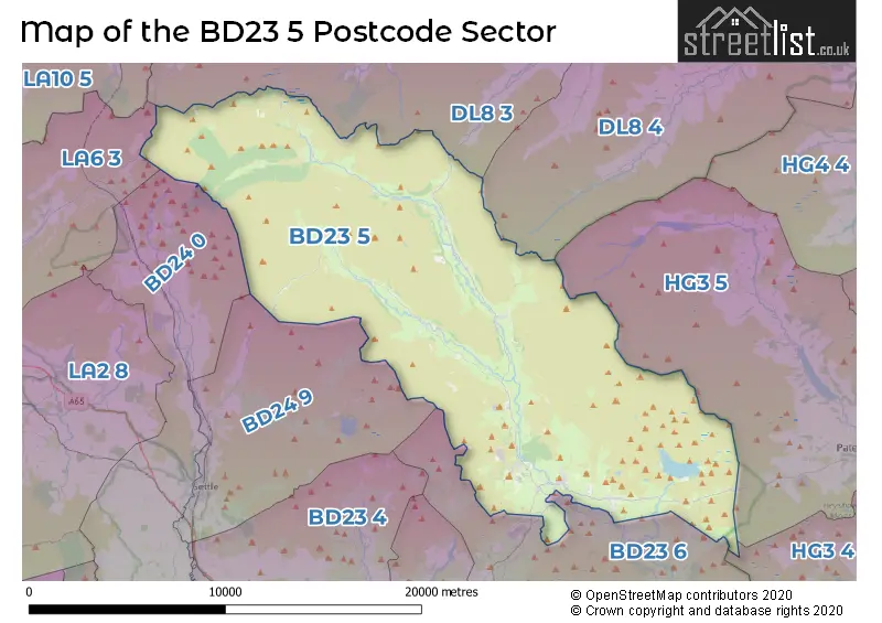
The BD23 5 Postcode shares a border with HG3 4 (Summerbridge, Dacre, Dacre Banks), HG3 5 (Greenhow Hill, Pateley Bridge, Glasshouses), BD23 6 (Embsay, Skyreholme, SKIPTON), BD24 0 (Giggleswick, Horton-in-Ribblesdale, Rathmell), BD24 9 (SETTLE, Langcliffe, Stainforth), DL8 3 (Askrigg, HAWES, Bainbridge), DL8 4 (Middleham, Preston Under Scar, Redmire) and LA6 3 (Ingleton, Burton In Lonsdale, Chapel Le Dale).
The sector is within the post town of SKIPTON.
BD23 5 is a postcode sector within the BD23 postcode district which is within the BD Bradford postcode area.
The Royal Mail delivery office for the BD23 5 postal sector is the Skipton Delivery Office and Wharfedale Delivery Office.
The area of the BD23 5 postcode sector is 115.13 square miles which is 298.18 square kilometres or 73,681.57 square acres.
Waterways within the BD23 5 postcode sector include the River Wharfe, River Skirfare, Outershaw Beck, Buckden Beck, River Dibb, Cam Beck, Gayle Beck, Hebden Beck, Duke's Water Course, Cowside Beck, Deepdale Gill, Cam Gill Beck, Groove Gill, Henless Beck, Gate Up Gill, Cote Gil, Mossdale Beck, Waterfall Gill Beck, Starton Beck, Eller Beck, Hamerton Hill Sike, Lainger Beck, How Gill, Bouther Gill, Hagg Beck, Green Field Beck, Dunstone Beck, Foxup Beck, Cosh Beck, Potts Beck, Wharfe.

Map of the BD23 5 Postcode Sector
Explore the BD23 5 postcode sector by using our free interactive map.
| B | D | 2 | 3 | - | 5 | X | X |
| B | D | 2 | 3 | Space | 5 | Letter | Letter |
Official List of Streets
Grassington (45 Streets)
Threshfield (23 Streets)
Hebden (12 Streets)
Buckden (2 Streets)
Kettlewell (8 Streets)
Starbotton (1 Streets)
Oughtershaw (1 Streets)
Unofficial Streets or Alternative Spellings
Hartlington
HARTLINGTON RAIKESGrassington
BROUGHTON FOLD GRASSWOOD LANE PLETTS FOLD SCAR FIELD 19TH CENTURY MINING PATH ACRE LANE BACK LANE BACKSTONE LANE BARE HOUSE LANE BISHOPDALE HEAD OCCUPATION ROAD BLACK HILL ROAD BLACKSTONES LANE BLEA MOOR ROAD BOW BRIDGE BRACKEN FIELD BRAZENGATE BROOTES LANE BROUGHTON BUCKDEN BECK BRIDGE BUCKDEN BRIDGE BUCKDEN GAVEL ROAD BUCKDEN RAKE BUCKDEN WOOD LANE BULL ING LANE BURNSALL LANE BYCLIFFE ROAD CAM GILL ROAD CAM HIGH ROAD CAM ROAD CAUSEWAY CHURCH LANE CONISTONE BRIDGE CONISTONE LANE CRAGG VIEW CRYSTAL BECK BRIDGE DEEPDALE BRIDGE DIBBLES BRIDGE DOWBER GILL BRIDGE DUBBS LANE DUKES NEW ROAD EAST DIB ROAD EAST SIDE ROAD EASTSIDE ROAD EDGE LANE ETSDONS ROAD FOREST ROAD FOXUP BRIDGE FOXUP ROAD GARROS LANE GILBERT LANE GOOSELANDS HILL GRASS WOOD GREEN LANE GRIMWITH ROAD HALTON GILL BRIDGE HARD GATE HARTLINGTON MOOR LANE HAWKSWICK BRIDGE HAWKSWICK HEAD LANE HEBDEN BRIDGE HEBDEN HIPPINGS HIGHCROFT HIGHGATE LEYS LANE HILLSIDE DRIVE HOLES BECK BRIDGE HUBBERHOLME BRIDGE INGS ROAD ISINGDALE BRIDGE JAMES LANE KETTLEWELL BRIDGE KETTLEWELL CAM TOP ROAD KILN DRIVE KIRK BANK LANGSTROTH DALE ROAD LAURADALE LANE LIMEKILN LANE LINTON BRIDGE LONG LANE LYTHE FLAT LANE MALHAM MOOR LANE MASTILES LANE MERE LANE MILL BRIDGE MILL LANE MIRE LANE MONKS ROAD MOSSDALE NEW BRIDGE NEW ROAD OLD HALL CROFT OLD MINING PATH OLD MOOR LANE ORCHARD LANE OUT GANG LANE PARK LANE RAIN SLACK RAKES SANDY GATE SCABBATE GATE SCOT GATE LANE SEAL BANK SILVER RAKE SILVERDALE ROAD SKYREHOLME BANK SLEETS GILL BRIDGE SOUTH NOOK BRIDGE STARBOTTOM CAM ROAD STARBOTTON FELL ROAD STARBOTTON ROAD STUBBING BRIDGE STUBBING LANE SUSPENSION BRIDGE SWARTHGHYLL SWARTHGILL FARM TARNS LANE THE OLD BRIDGE THORPE LANE THRESHFIELD BRIDGE TIN BRIDGE TINKERS LANE TIPPERING LANE TOP MERE ROAD TOPHAMS ROAD TURF ROAD WALDEN ROAD WELL LANE WEST CAM ROAD WHARFE LANE WHERNSIDE TURF ROAD WHITE NOOK BRIDGE WISP HILLThreshfield
WOODLANDS TERRACEWeather Forecast for BD23 5
Press Button to Show Forecast for Arncliffe
| Time Period | Icon | Description | Temperature | Rain Probability | Wind |
|---|---|---|---|---|---|
| 21:00 to 00:00 | Cloudy | 4.0°C (feels like 2.0°C) | 6.00% | E 4 mph |
Press Button to Show Forecast for Arncliffe
| Time Period | Icon | Description | Temperature | Rain Probability | Wind |
|---|---|---|---|---|---|
| 00:00 to 03:00 | Clear night | 1.0°C (feels like 0.0°C) | 1.00% | E 2 mph | |
| 03:00 to 06:00 | Clear night | 1.0°C (feels like -1.0°C) | 1.00% | NNE 4 mph | |
| 06:00 to 09:00 | Sunny day | 3.0°C (feels like 1.0°C) | 1.00% | NNE 4 mph | |
| 09:00 to 12:00 | Partly cloudy (day) | 7.0°C (feels like 4.0°C) | 2.00% | ENE 9 mph | |
| 12:00 to 15:00 | Overcast | 8.0°C (feels like 6.0°C) | 11.00% | ENE 11 mph | |
| 15:00 to 18:00 | Light rain | 8.0°C (feels like 5.0°C) | 47.00% | ENE 9 mph | |
| 18:00 to 21:00 | Cloudy | 7.0°C (feels like 4.0°C) | 10.00% | ENE 9 mph | |
| 21:00 to 00:00 | Cloudy | 5.0°C (feels like 2.0°C) | 6.00% | NE 7 mph |
Press Button to Show Forecast for Arncliffe
| Time Period | Icon | Description | Temperature | Rain Probability | Wind |
|---|---|---|---|---|---|
| 00:00 to 03:00 | Cloudy | 3.0°C (feels like 1.0°C) | 4.00% | NNE 7 mph | |
| 03:00 to 06:00 | Cloudy | 3.0°C (feels like 0.0°C) | 4.00% | NNE 9 mph | |
| 06:00 to 09:00 | Cloudy | 4.0°C (feels like 1.0°C) | 9.00% | NNE 11 mph | |
| 09:00 to 12:00 | Light rain | 6.0°C (feels like 3.0°C) | 44.00% | N 11 mph | |
| 12:00 to 15:00 | Light rain | 7.0°C (feels like 4.0°C) | 46.00% | NW 11 mph | |
| 15:00 to 18:00 | Overcast | 9.0°C (feels like 6.0°C) | 18.00% | WNW 11 mph | |
| 18:00 to 21:00 | Partly cloudy (day) | 8.0°C (feels like 6.0°C) | 7.00% | W 9 mph | |
| 21:00 to 00:00 | Clear night | 4.0°C (feels like 2.0°C) | 2.00% | WSW 7 mph |
Press Button to Show Forecast for Arncliffe
| Time Period | Icon | Description | Temperature | Rain Probability | Wind |
|---|---|---|---|---|---|
| 00:00 to 03:00 | Partly cloudy (night) | 4.0°C (feels like 2.0°C) | 2.00% | SW 7 mph | |
| 03:00 to 06:00 | Partly cloudy (night) | 3.0°C (feels like 1.0°C) | 5.00% | SSW 7 mph | |
| 06:00 to 09:00 | Cloudy | 5.0°C (feels like 2.0°C) | 10.00% | S 7 mph | |
| 09:00 to 12:00 | Partly cloudy (day) | 9.0°C (feels like 6.0°C) | 6.00% | S 11 mph | |
| 12:00 to 15:00 | Cloudy | 12.0°C (feels like 9.0°C) | 9.00% | S 13 mph | |
| 15:00 to 18:00 | Cloudy | 12.0°C (feels like 9.0°C) | 10.00% | S 13 mph | |
| 18:00 to 21:00 | Cloudy | 11.0°C (feels like 9.0°C) | 12.00% | S 11 mph | |
| 21:00 to 00:00 | Clear night | 9.0°C (feels like 6.0°C) | 5.00% | SSE 9 mph |
Press Button to Show Forecast for Arncliffe
| Time Period | Icon | Description | Temperature | Rain Probability | Wind |
|---|---|---|---|---|---|
| 00:00 to 03:00 | Clear night | 7.0°C (feels like 5.0°C) | 5.00% | SE 9 mph | |
| 03:00 to 06:00 | Clear night | 6.0°C (feels like 3.0°C) | 4.00% | SE 7 mph | |
| 06:00 to 09:00 | Cloudy | 7.0°C (feels like 4.0°C) | 6.00% | ESE 9 mph | |
| 09:00 to 12:00 | Partly cloudy (day) | 10.0°C (feels like 8.0°C) | 5.00% | ESE 11 mph | |
| 12:00 to 15:00 | Partly cloudy (day) | 14.0°C (feels like 11.0°C) | 6.00% | ESE 13 mph | |
| 15:00 to 18:00 | Partly cloudy (day) | 14.0°C (feels like 12.0°C) | 9.00% | ESE 13 mph | |
| 18:00 to 21:00 | Partly cloudy (day) | 13.0°C (feels like 11.0°C) | 8.00% | ESE 9 mph | |
| 21:00 to 00:00 | Partly cloudy (night) | 10.0°C (feels like 8.0°C) | 5.00% | E 9 mph |
Schools and Places of Education Within the BD23 5 Postcode Sector
Grassington Church of England Voluntary Controlled Primary School
Voluntary controlled school
Hebden Road, Skipton, North Yorkshire, BD23 5LB
Head: Mrs Claire Greenwood and Mr Chris Parkhouse
Ofsted Rating: Good
Inspection: 2022-11-18 (525 days ago)
Website: Visit Grassington Church of England Voluntary Controlled Primary School Website
Phone: 01756752365
Number of Pupils: 54
Kettlewell Primary School
Community school
Kettlewell, Skipton, North Yorkshire, BD23 5HX
Head: Mrs Claire Greenwood Mr Chris Parkhouse
Ofsted Rating: Good
Inspection: 2019-07-10 (1752 days ago)
Website: Visit Kettlewell Primary School Website
Phone: 01756760280
Number of Pupils: 26
Threshfield School
Voluntary controlled school
Low Road, Skipton, North Yorkshire, BD23 5NP
Head: Miss Sarah Harper
Ofsted Rating: Good
Inspection: 2023-11-22 (156 days ago)
Website: Visit Threshfield School Website
Phone: 01756752348
Number of Pupils: 102
Upper Wharfedale School
Community school
Wharfeside Avenue, Skipton, North Yorkshire, BD23 5BS
Head: Mr Ian Chapman
Ofsted Rating: Outstanding
Inspection: 2019-06-06 (1786 days ago)
Website: Visit Upper Wharfedale School Website
Phone: 01756752215
Number of Pupils: 356
House Prices in the BD23 5 Postcode Sector
| Type of Property | 2018 Average | 2018 Sales | 2017 Average | 2017 Sales | 2016 Average | 2016 Sales | 2015 Average | 2015 Sales |
|---|---|---|---|---|---|---|---|---|
| Detached | £461,629 | 19 | £498,723 | 26 | £490,083 | 18 | £409,130 | 30 |
| Semi-Detached | £312,116 | 16 | £356,308 | 14 | £310,881 | 13 | £276,912 | 17 |
| Terraced | £271,503 | 17 | £253,196 | 28 | £278,261 | 22 | £239,484 | 27 |
| Flats | £125,000 | 1 | £159,750 | 8 | £174,206 | 7 | £158,400 | 5 |
Important Postcodes BD23 5 in the Postcode Sector
BD23 5BS is the postcode for MAIN BUILDING, Upper Wharfedale School, Wharfeside Avenue, Upper Wharfedale School, Wharfeside Avenue, and Upper Wharfedale School, Wharfeside Avenue, Threshfield
BD23 5HX is the postcode for Kettlewell Primary School, Kettlewell
BD23 5JA is the postcode for Education Bradford, Buckden House,
BD23 5LB is the postcode for Grassington C of E Primary School, Hebden Road, COLVEND OFFICES, Yorkshire Dales National Park Authority, Colvend, Hebden Road, and Grassington C Of E Primary School, Hebden Road, Grassington
BD23 5LS is the postcode for Grassington Medical Centre, 9 Station Road
BD23 5NP is the postcode for Threshfield Primary School, Threshfield
BD23 5PP is the postcode for Netherside Hall School, Threshfield, and NETHERSIDE HALL, Netherside Hall School, Threshfield
| The BD23 5 Sector is within these Local Authorities |
|
|---|---|
| The BD23 5 Sector is within these Counties |
|
| The BD23 5 Sector is within these Water Company Areas |
|
Tourist Attractions within the BD23 5 Postcode Area
We found 1 visitor attractions within the BD23 postcode area
| Yorkshire Dale National Park Authority |
|---|
| Visitor Centres |
| Heritage / Visitor Centre |
| View Yorkshire Dale National Park Authority on Google Maps |