The HG3 5 postcode sector is within the county of North Yorkshire.
Did you know? According to the 2021 Census, the HG3 5 postcode sector is home to a bustling 3,324 residents!
Given that each sector allows for 400 unique postcode combinations. Letters C, I, K, M, O and V are not allowed in the last two letters of a postcode. With 202 postcodes already in use, this leaves 198 units available.
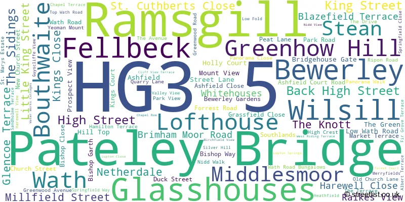
The largest settlement in the HG3 5 postal code is Greenhow Hill followed by Pateley Bridge, and Glasshouses.
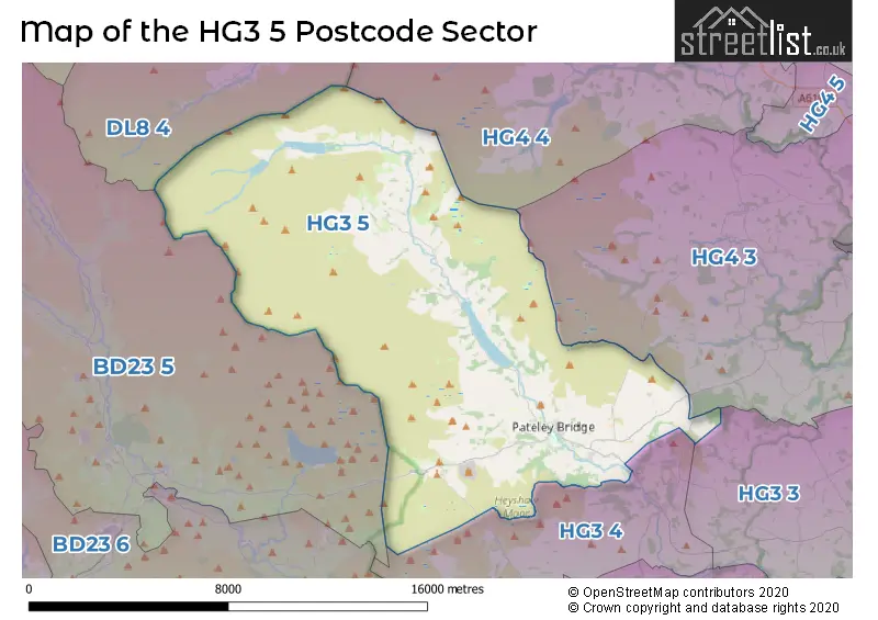
The HG3 5 Postcode shares a border with HG3 3 (Bishop Monkton, Burton Leonard, Bishop Thornton), HG3 4 (Summerbridge, Dacre, Dacre Banks), HG4 3 (Kirkby Malzeard, Grewelthorpe, North Stainley), BD23 5 (Grassington, Threshfield, Kettlewell), DL8 4 (Middleham, Preston Under Scar, Redmire) and HG4 4 (Masham, Healey, Thornton Watlass).
The sector is within the post town of HARROGATE.
HG3 5 is a postcode sector within the HG3 postcode district which is within the HG Harrogate postcode area.
The Royal Mail delivery office for the HG3 5 postal sector is the Pateley Bridge Scale Payment Delivery Office.
The area of the HG3 5 postcode sector is 72.66 square miles which is 188.19 square kilometres or 46,502.59 square acres.
Waterways within the HG3 5 postcode sector include the River Nidd, How Stean Beck, Ramsgill Beck, Long Hill Sike, Arkleside Gill, Woo Gill, Armathwaite Gill, Whit Beck, Great Blowing Gill Beck, Straight Stean Beck, Meugher Dike, Sandy Dike, Skell Beck, Blackston Gill, Gate Up Gill, Greenhow Sike, Colt House Gill, Swine Beck, Knott's Gill, Burn Gill, Rowantree Gill, Brandstone Beck, Tarn Gill, Rochard Dike, Skell Gill, Blayshaw Gill, Aygill Beck, Lul Beck, Backstean Gill, Stone Beck.

Map of the HG3 5 Postcode Sector
Explore the HG3 5 postcode sector by using our free interactive map.
| H | G | 3 | - | 5 | X | X |
| H | G | 3 | Space | 5 | Letter | Letter |
Official List of Streets
Glasshouses (15 Streets)
Pateley Bridge (46 Streets)
Bewerley (6 Streets)
Fellbeck (2 Streets)
Lofthouse (3 Streets)
Wath (1 Streets)
Greenhow Hill (2 Streets)
Ramsgill (1 Streets)
Wilsill (1 Streets)
Unofficial Streets or Alternative Spellings
Burnt Yates
BRIMHAM ROCKS ROADPateley Bridge
KINGS COURTGrassington
HEBDEN ROADWeather Forecast for HG3 5
Press Button to Show Forecast for Greenhow Hill
| Time Period | Icon | Description | Temperature | Rain Probability | Wind |
|---|---|---|---|---|---|
| 09:00 to 12:00 | Overcast | 3.0°C (feels like 0.0°C) | 9.00% | NE 7 mph | |
| 12:00 to 15:00 | Cloudy | 4.0°C (feels like 2.0°C) | 34.00% | NE 4 mph | |
| 15:00 to 18:00 | Cloudy | 5.0°C (feels like 3.0°C) | 10.00% | ENE 4 mph | |
| 18:00 to 21:00 | Light rain | 4.0°C (feels like 2.0°C) | 38.00% | ENE 7 mph | |
| 21:00 to 00:00 | Cloudy | 1.0°C (feels like -1.0°C) | 8.00% | ENE 4 mph |
Press Button to Show Forecast for Greenhow Hill
| Time Period | Icon | Description | Temperature | Rain Probability | Wind |
|---|---|---|---|---|---|
| 00:00 to 03:00 | Partly cloudy (night) | 0.0°C (feels like -2.0°C) | 3.00% | ESE 4 mph | |
| 03:00 to 06:00 | Cloudy | 0.0°C (feels like -2.0°C) | 8.00% | NNE 2 mph | |
| 06:00 to 09:00 | Cloudy | 1.0°C (feels like -2.0°C) | 8.00% | NNE 2 mph | |
| 09:00 to 12:00 | Partly cloudy (day) | 4.0°C (feels like 1.0°C) | 7.00% | E 7 mph | |
| 12:00 to 15:00 | Overcast | 6.0°C (feels like 4.0°C) | 14.00% | E 9 mph | |
| 15:00 to 18:00 | Cloudy | 7.0°C (feels like 4.0°C) | 14.00% | E 9 mph | |
| 18:00 to 21:00 | Cloudy | 5.0°C (feels like 2.0°C) | 14.00% | E 9 mph | |
| 21:00 to 00:00 | Cloudy | 3.0°C (feels like -1.0°C) | 14.00% | ENE 7 mph |
Press Button to Show Forecast for Greenhow Hill
| Time Period | Icon | Description | Temperature | Rain Probability | Wind |
|---|---|---|---|---|---|
| 00:00 to 03:00 | Cloudy | 2.0°C (feels like -2.0°C) | 15.00% | NE 9 mph | |
| 03:00 to 06:00 | Cloudy | 2.0°C (feels like -2.0°C) | 20.00% | NNE 9 mph | |
| 06:00 to 09:00 | Light rain | 3.0°C (feels like -1.0°C) | 46.00% | NNE 11 mph | |
| 09:00 to 12:00 | Heavy rain | 4.0°C (feels like 0.0°C) | 74.00% | NE 13 mph | |
| 12:00 to 15:00 | Light rain | 5.0°C (feels like 2.0°C) | 55.00% | NNE 13 mph | |
| 15:00 to 18:00 | Heavy rain | 6.0°C (feels like 3.0°C) | 78.00% | N 9 mph | |
| 18:00 to 21:00 | Light rain shower (day) | 6.0°C (feels like 4.0°C) | 38.00% | N 7 mph | |
| 21:00 to 00:00 | Cloudy | 4.0°C (feels like 1.0°C) | 14.00% | N 7 mph |
Schools and Places of Education Within the HG3 5 Postcode Sector
Fountains Earth, Lofthouse Church of England Endowed Primary School
Voluntary controlled school
Fountains Earth, Harrogate, North Yorkshire, HG3 5RZ
Head: Miss Nicola Thornber
Ofsted Rating: Good
Inspection: 2022-06-29 (667 days ago)
Website: Visit Fountains Earth, Lofthouse Church of England Endowed Primary School Website
Phone: 01423755289
Number of Pupils: 15
Glasshouses Community Primary School
Community school
Glasshouses, Harrogate, North Yorkshire, HG3 5QH
Head: Miss Nicola Thornber
Ofsted Rating: Good
Inspection: 2022-03-30 (758 days ago)
Website: Visit Glasshouses Community Primary School Website
Phone: 01423711440
Number of Pupils: 50
St Cuthbert's Church of England Primary School, Pateley Bridge
Voluntary controlled school
King Street, Harrogate, North Yorkshire, HG3 5LE
Head: Miss Nicola Thornber
Ofsted Rating: Good
Inspection: 2022-10-13 (561 days ago)
Website: Visit St Cuthbert's Church of England Primary School, Pateley Bridge Website
Phone: 01423711407
Number of Pupils: 50
House Prices in the HG3 5 Postcode Sector
| Type of Property | 2018 Average | 2018 Sales | 2017 Average | 2017 Sales | 2016 Average | 2016 Sales | 2015 Average | 2015 Sales |
|---|---|---|---|---|---|---|---|---|
| Detached | £438,391 | 15 | £492,536 | 14 | £420,165 | 36 | £342,674 | 23 |
| Semi-Detached | £282,900 | 10 | £193,056 | 8 | £253,923 | 13 | £234,458 | 13 |
| Terraced | £232,374 | 14 | £212,549 | 20 | £213,816 | 22 | £199,305 | 19 |
| Flats | £195,488 | 4 | £555,000 | 1 | £242,000 | 5 | £128,192 | 2 |
Important Postcodes HG3 5 in the Postcode Sector
HG3 5AT is the postcode for Feastfield Medical Centre, King Street
HG3 5HL is the postcode for SPORTS HALL, Nidderdale High School & Community College, Low Wath Road, Nidderdale Pool and Leisure Centre, Low Wath Road, MAIN SCHOOL BUILDING, Nidderdale High School & Community College, Low Wath Road, and Nidderdale High School & Community College, Low Wath Road
HG3 5JB is the postcode for BLOCK 2, Bewerley Park Centre For Outdoor Education, Bewerley, DINING ROOM AND KITCHEN, Bewerley Park Centre For Outdoor Education, Bewerley, BLOCK 4 AND 5, Bewerley Park Centre For Outdoor Education, Bewerley, Bewerley Park Centre For Outdoor Education, Bewerley, and ASSEMBLY HALL, Bewerley Park Centre For Outdoor Education, Bewerley
HG3 5LE is the postcode for MAIN SCHOOL BUILDING, St. Cuthberts C of E Primary School, King Street, and St. Cuthberts C of E Primary School, King Street
HG3 5QH is the postcode for Glasshouses Cp School, Glasshouses
| The HG3 5 Sector is within these Local Authorities |
|
|---|---|
| The HG3 5 Sector is within these Counties |
|
| The HG3 5 Sector is within these Water Company Areas |
|