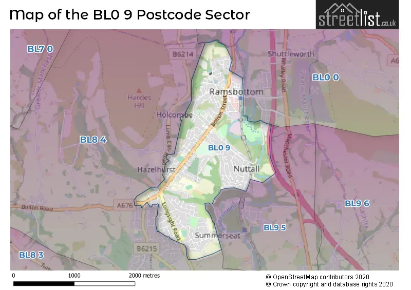
The BL0 9 postcode sector stands on the Greater Manchester and Lancashire border.
Did you know? According to the 2021 Census, the BL0 9 postcode sector is home to a bustling 11,722 residents!
Given that each sector allows for 400 unique postcode combinations. Letters C, I, K, M, O and V are not allowed in the last two letters of a postcode. With 333 postcodes already in use, this leaves 67 units available.
The BL0 9 postal code covers the settlement of Ramsbottom.
The BL0 9 Postcode shares a border with BL0 0 (Ramsbottom), BL8 4 (Greenmount, Hawkshaw, Tottington) and BL9 5 (BURY, Summerseat, Walmersley).
The sector is within the post town of BURY.
BL0 9 is a postcode sector within the BL0 postcode district which is within the BL Bolton postcode area.
The Royal Mail delivery office for the BL0 9 postal sector is the unknown.
The area of the BL0 9 postcode sector is 1.45 square miles which is 3.75 square kilometres or 926.32 square acres.
The BL0 9 postcode sector is crossed by the M66 motorway.
Waterways within the BL0 9 postcode sector include the Irwell.

Map of the BL0 9 Postcode Sector
Explore the BL0 9 postcode sector by using our free interactive map.
| B | L | 0 | - | 9 | X | X |
| B | L | 0 | Space | 9 | Letter | Letter |
Official List of Streets
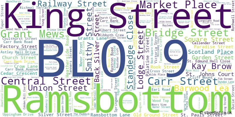
Ramsbottom (254 Streets)
Unofficial Streets or Alternative Spellings
Ramsbottom
NUTTALL HALL ROAD STUBBINS LANE AJAX STREET ATHOL STREET BACK BRIDGE STREET BACK STANLEY STREET BALM STREET BROOKSBOTTOM CLOSE BROWN STREET CALTHA STREET CHARLOTTE STREET DOROTHY STREET EDGAR STREET WEST ELECTRIC AVENUE ELSIE STREET FLAX STREET GLEN STREET HAIL STREET JOY STREET KATE STREET KERENHAPPUCH STREET KILLER STREET KILN STREET LEVER STREET LOW STREET MARKLAND STREET MILL STREET NUTTALL ROAD OX STREET PERCY STREET PILKINGTON STREET RAKE SAINT EDMUND HALL CLOSE SALMSBURY HALL CLOSE SIMMS CLOSE SMITH STREET SPENCER STREET SPRING WOOD STREET SPRUCE STREET ST CLAIR ROAD STANEDGE CLOSE STRANG STREET SUN STREET TAG WOOD VIEW TAPE STREET VESTA STREET VILLAGE LINK TRAIL WELL STREET WEST WOOD STREET ZAMA STREETGreenmount
BYRON ROAD HOLCOMBE ROAD KEATS ROAD LONGSIGHT ROAD NABBS FOLD SANDRINGHAM DRIVE STRETTON ROADSummerseat
PEEL HALL ROADHolcombe
BOOTHWOOD STILE HOLCOMBE OLD ROAD LUMB CARR ROADHawkshaw
BOLTON ROADWeather Forecast for BL0 9
Press Button to Show Forecast for Ramsbottom
| Time Period | Icon | Description | Temperature | Rain Probability | Wind |
|---|---|---|---|---|---|
| 06:00 to 09:00 | Partly cloudy (day) | 4.0°C (feels like 1.0°C) | 2.00% | NE 7 mph | |
| 09:00 to 12:00 | Cloudy | 7.0°C (feels like 4.0°C) | 5.00% | ENE 9 mph | |
| 12:00 to 15:00 | Cloudy | 9.0°C (feels like 6.0°C) | 10.00% | ENE 9 mph | |
| 15:00 to 18:00 | Cloudy | 8.0°C (feels like 6.0°C) | 15.00% | ENE 11 mph | |
| 18:00 to 21:00 | Overcast | 8.0°C (feels like 5.0°C) | 14.00% | ENE 9 mph | |
| 21:00 to 00:00 | Cloudy | 6.0°C (feels like 3.0°C) | 4.00% | NE 9 mph |
Press Button to Show Forecast for Ramsbottom
| Time Period | Icon | Description | Temperature | Rain Probability | Wind |
|---|---|---|---|---|---|
| 00:00 to 03:00 | Cloudy | 4.0°C (feels like 1.0°C) | 4.00% | NE 9 mph | |
| 03:00 to 06:00 | Cloudy | 4.0°C (feels like 1.0°C) | 4.00% | NNE 9 mph | |
| 06:00 to 09:00 | Cloudy | 5.0°C (feels like 1.0°C) | 13.00% | NNE 9 mph | |
| 09:00 to 12:00 | Light rain | 6.0°C (feels like 3.0°C) | 45.00% | N 9 mph | |
| 12:00 to 15:00 | Light rain | 8.0°C (feels like 6.0°C) | 45.00% | NW 9 mph | |
| 15:00 to 18:00 | Cloudy | 9.0°C (feels like 7.0°C) | 14.00% | WNW 11 mph | |
| 18:00 to 21:00 | Sunny day | 9.0°C (feels like 6.0°C) | 6.00% | W 9 mph | |
| 21:00 to 00:00 | Clear night | 6.0°C (feels like 4.0°C) | 2.00% | WSW 7 mph |
Press Button to Show Forecast for Ramsbottom
| Time Period | Icon | Description | Temperature | Rain Probability | Wind |
|---|---|---|---|---|---|
| 00:00 to 03:00 | Clear night | 5.0°C (feels like 3.0°C) | 1.00% | SSW 7 mph | |
| 03:00 to 06:00 | Clear night | 4.0°C (feels like 2.0°C) | 3.00% | S 7 mph | |
| 06:00 to 09:00 | Cloudy | 5.0°C (feels like 2.0°C) | 7.00% | S 9 mph | |
| 09:00 to 12:00 | Partly cloudy (day) | 9.0°C (feels like 6.0°C) | 3.00% | S 11 mph | |
| 12:00 to 15:00 | Overcast | 12.0°C (feels like 9.0°C) | 12.00% | S 16 mph | |
| 15:00 to 18:00 | Cloudy | 12.0°C (feels like 9.0°C) | 11.00% | S 13 mph | |
| 18:00 to 21:00 | Cloudy | 12.0°C (feels like 9.0°C) | 10.00% | S 11 mph | |
| 21:00 to 00:00 | Clear night | 10.0°C (feels like 7.0°C) | 6.00% | SSE 11 mph |
Press Button to Show Forecast for Ramsbottom
| Time Period | Icon | Description | Temperature | Rain Probability | Wind |
|---|---|---|---|---|---|
| 00:00 to 03:00 | Clear night | 8.0°C (feels like 6.0°C) | 4.00% | SE 9 mph | |
| 03:00 to 06:00 | Partly cloudy (night) | 8.0°C (feels like 5.0°C) | 4.00% | SE 9 mph | |
| 06:00 to 09:00 | Sunny day | 8.0°C (feels like 5.0°C) | 3.00% | ESE 9 mph | |
| 09:00 to 12:00 | Partly cloudy (day) | 11.0°C (feels like 8.0°C) | 5.00% | ESE 13 mph | |
| 12:00 to 15:00 | Partly cloudy (day) | 14.0°C (feels like 11.0°C) | 6.00% | ESE 13 mph | |
| 15:00 to 18:00 | Cloudy | 15.0°C (feels like 12.0°C) | 10.00% | ESE 11 mph | |
| 18:00 to 21:00 | Partly cloudy (day) | 14.0°C (feels like 12.0°C) | 7.00% | ESE 11 mph | |
| 21:00 to 00:00 | Cloudy | 11.0°C (feels like 9.0°C) | 7.00% | E 9 mph |
Schools and Places of Education Within the BL0 9 Postcode Sector
Holcombe Brook Primary School
Community school
Longsight Road, Bury, Lancashire, BL0 9TA
Head: Mr David Westerby
Ofsted Rating: Good
Inspection: 2020-03-12 (1507 days ago)
Website: Visit Holcombe Brook Primary School Website
Phone: 01204882304
Number of Pupils: 269
St Andrew's Church of England Primary School, Ramsbottom
Voluntary controlled school
Nuttall Lane, Bury, Lancashire, BL0 9JD
Head: Mr Damian Marsh
Ofsted Rating: Good
Inspection: 2021-10-07 (933 days ago)
Website: Visit St Andrew's Church of England Primary School, Ramsbottom Website
Phone: 01706822649
Number of Pupils: 243
St Joseph's Roman Catholic Primary School, Ramsbottom
Voluntary aided school
Queen Street, Bury, Lancashire, BL0 9JJ
Head: Mrs Emma Moncado
Ofsted Rating: Good
Inspection: 2023-11-15 (164 days ago)
Website: Visit St Joseph's Roman Catholic Primary School, Ramsbottom Website
Phone: 01706823645
Number of Pupils: 197
Woodhey High School
Academy converter
Bolton Road West, Bury, Lancashire, BL0 9QZ
Head: Mr Dean Watson
Ofsted Rating: Requires improvement
Inspection: 2022-10-19 (556 days ago)
Website: Visit Woodhey High School Website
Phone: 01706825215
Number of Pupils: 1114
House Prices in the BL0 9 Postcode Sector
| Type of Property | 2018 Average | 2018 Sales | 2017 Average | 2017 Sales | 2016 Average | 2016 Sales | 2015 Average | 2015 Sales |
|---|---|---|---|---|---|---|---|---|
| Detached | £320,845 | 53 | £279,053 | 66 | £281,047 | 75 | £291,769 | 67 |
| Semi-Detached | £205,698 | 60 | £200,434 | 53 | £187,980 | 55 | £180,383 | 54 |
| Terraced | £166,840 | 92 | £154,324 | 97 | £147,643 | 89 | £147,765 | 73 |
| Flats | £112,556 | 8 | £136,923 | 13 | £162,276 | 92 | £83,740 | 5 |
Important Postcodes BL0 9 in the Postcode Sector
BL0 9AE is the postcode for Bury Metropolitan Borough Council, Ramsbottom Library, Carr Street
BL0 9AJ is the postcode for Ramsbottom Civic Hall, Market Chambers, Market Place
BL0 9DD is the postcode for Ramsbottom Health Centre, Carr Street
BL0 9JD is the postcode for St. Andrews C of E Primary School, Bolton Street, and St. Andrews C of E Primary School, Bolton Street, Ramsbottom
BL0 9JJ is the postcode for St. Josephs RC Primary School, Queen Street, Ramsbottom, and St. Josephs RC Primary School, Queen Street
BL0 9PJ is the postcode for Hazelhurst Elderly Persons Home, Bolton Road West
BL0 9PQ is the postcode for Hazelhurst Cp School, Geoffrey Street, Ramsbottom, and Hazelhurst Cp School, Geoffrey Street
BL0 9QZ is the postcode for FRANK BENNETT HALL, Woodhey High School, Bolton Road West, SPORTS HALL, Woodhey High School, Bolton Road West, and MAIN BUILDING, Woodhey High School, Bolton Road West
BL0 9TA is the postcode for Holcombe Brook Cp School, Longsight Road, Ramsbottom, and Holcombe Brook Cp School, Longsight Road
BL0 9UD is the postcode for Pupil Learning Centre, New Summerseat House, Summerseat Lane, and MAIN BUILDING, Pupil Learning Centre, New Summerseat House, Summerseat Lane
| The BL0 9 Sector is within these Local Authorities |
|
|---|---|
| The BL0 9 Sector is within these Counties |
|
| The BL0 9 Sector is within these Water Company Areas |
|