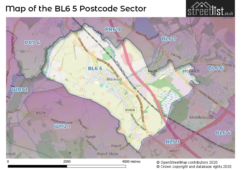
The BL6 5 postcode sector stands on the Greater Manchester and Lancashire border.
Did you know? According to the 2021 Census, the BL6 5 postcode sector is home to a bustling 10,651 residents!
Given that each sector allows for 400 unique postcode combinations. Letters C, I, K, M, O and V are not allowed in the last two letters of a postcode. With 283 postcodes already in use, this leaves 117 units available.
The largest settlements in the BL6 5 postal code are Blackrod and Horwich.
The BL6 5 Postcode shares a border with BL5 3 (Westhoughton), PR6 9 (Adlington, Heath Charnock, Anderton), PR7 4 (Coppull, Adlington, CHORLEY), WN1 2 (WIGAN, Standish, Haigh), WN2 1 (Aspull, WIGAN, Haigh), BL6 7 (Horwich, Rivington) and BL6 6 (Horwich).
The sector is within the post town of BOLTON.
BL6 5 is a postcode sector within the BL6 postcode district which is within the BL Bolton postcode area.
The Royal Mail delivery office for the BL6 5 postal sector is the Bolton West Delivery Office.
The area of the BL6 5 postcode sector is 4.22 square miles which is 10.92 square kilometres or 2,699.61 square acres.
The BL6 5 postcode sector is crossed by the M61 motorway.
Waterways within the BL6 5 postcode sector include the Pearl Brook, Leeds and Liverpool Canal.

Map of the BL6 5 Postcode Sector
Explore the BL6 5 postcode sector by using our free interactive map.
| B | L | 6 | - | 5 | X | X |
| B | L | 6 | Space | 5 | Letter | Letter |
Official List of Streets
Blackrod (85 Streets)
Horwich (68 Streets)
Unofficial Streets or Alternative Spellings
Horwich
ARKWRIGHT STREET BEATRICE MEWS BERNE AVENUE CATHERINES CLOSE CHURCH STREET CURTEIS CLOSE CURTEIS STREET GEORGE STREET MOTTRAM STREET THIRLMERE AVENUE WINTER HEY LANE ANDERTON BRIDGE ANDERTON LANE BACK ARMSTRONG STREET BACK BARLOW STREET BACK CHORLEY NEW ROAD BACK CHORLEY NEW ROAD EAST BACK CHORLEY NEW ROAD SOUTH BACK CHORLEY ROAD BACK CROWN LANE BACK FAIRBAIRN STREET BACK HARTLEY STREET BACK HAWKSHAW STREET BACK LEICESTER AVENUE BACK MASON STREET BACK MELBOURNE GROVE BACK MELBOURNE GROVE SOUTH BACK NASMYTH STREET BACK NEW STREET BACK PENN STREET BACK RAMSBOTTOM ROAD BACK RICHMOND STREET BACK SIEMENS STREET BACK STATION ROAD BACK STATION ROAD (SOUTH) BACK STEPHENSON STREET BACK TREDGOLD STREET BACK VICTORIA ROAD BACK WATTS STREET BACK WEBB STREET BACK WHITWORTH STREET BEATRICE STREET BLACKROD BY-PASS ROAD BRINDLEY STREET BUTTERWICK FIELD COPPERAS LANE DRINKWATER LANE FOLDS FOUNDARY ROAD GREENLAND LANE GREGORYS ROAD GROSVERNOR WAY HILLTON AVENUE INVERARY AVENUE LODGE BANK MANCHESTER - PRESTON MOTORWAY RIDGWAY BRIDGE SMEATON STREET STATION APPROACH ROAD STATION YARD TUCKERS HILL BROW VICTORIA STREET WHITWORTH STREETAspull
SCOT LANEAnderton
GRIMEFORD LANEHaigh
ARLEY LANEWesthoughton
CHORLEY ROADWeather Forecast for BL6 5
Press Button to Show Forecast for Horwich
| Time Period | Icon | Description | Temperature | Rain Probability | Wind |
|---|---|---|---|---|---|
| 21:00 to 00:00 | Cloudy | 6.0°C (feels like 3.0°C) | 7.00% | E 9 mph |
Press Button to Show Forecast for Horwich
| Time Period | Icon | Description | Temperature | Rain Probability | Wind |
|---|---|---|---|---|---|
| 00:00 to 03:00 | Cloudy | 5.0°C (feels like 2.0°C) | 4.00% | E 9 mph | |
| 03:00 to 06:00 | Partly cloudy (night) | 4.0°C (feels like 1.0°C) | 1.00% | ENE 9 mph | |
| 06:00 to 09:00 | Partly cloudy (day) | 4.0°C (feels like 1.0°C) | 2.00% | ENE 9 mph | |
| 09:00 to 12:00 | Cloudy | 8.0°C (feels like 5.0°C) | 5.00% | E 9 mph | |
| 12:00 to 15:00 | Cloudy | 9.0°C (feels like 7.0°C) | 8.00% | ENE 9 mph | |
| 15:00 to 18:00 | Light rain | 9.0°C (feels like 7.0°C) | 48.00% | NE 9 mph | |
| 18:00 to 21:00 | Cloudy | 8.0°C (feels like 6.0°C) | 46.00% | ENE 9 mph | |
| 21:00 to 00:00 | Cloudy | 7.0°C (feels like 4.0°C) | 5.00% | NE 9 mph |
Press Button to Show Forecast for Horwich
| Time Period | Icon | Description | Temperature | Rain Probability | Wind |
|---|---|---|---|---|---|
| 00:00 to 03:00 | Cloudy | 5.0°C (feels like 3.0°C) | 4.00% | NE 7 mph | |
| 03:00 to 06:00 | Cloudy | 5.0°C (feels like 2.0°C) | 5.00% | NNE 9 mph | |
| 06:00 to 09:00 | Cloudy | 5.0°C (feels like 2.0°C) | 10.00% | N 7 mph | |
| 09:00 to 12:00 | Overcast | 7.0°C (feels like 4.0°C) | 16.00% | NNW 9 mph | |
| 12:00 to 15:00 | Overcast | 9.0°C (feels like 7.0°C) | 18.00% | NW 9 mph | |
| 15:00 to 18:00 | Overcast | 10.0°C (feels like 7.0°C) | 17.00% | WNW 11 mph | |
| 18:00 to 21:00 | Sunny day | 9.0°C (feels like 7.0°C) | 5.00% | W 9 mph | |
| 21:00 to 00:00 | Partly cloudy (night) | 7.0°C (feels like 5.0°C) | 3.00% | WSW 7 mph |
Press Button to Show Forecast for Horwich
| Time Period | Icon | Description | Temperature | Rain Probability | Wind |
|---|---|---|---|---|---|
| 00:00 to 03:00 | Partly cloudy (night) | 6.0°C (feels like 4.0°C) | 2.00% | SSW 7 mph | |
| 03:00 to 06:00 | Clear night | 4.0°C (feels like 2.0°C) | 3.00% | SSE 7 mph | |
| 06:00 to 09:00 | Cloudy | 5.0°C (feels like 2.0°C) | 9.00% | SSE 7 mph | |
| 09:00 to 12:00 | Cloudy | 9.0°C (feels like 7.0°C) | 8.00% | S 11 mph | |
| 12:00 to 15:00 | Overcast | 12.0°C (feels like 9.0°C) | 11.00% | S 13 mph | |
| 15:00 to 18:00 | Cloudy | 13.0°C (feels like 10.0°C) | 9.00% | S 13 mph | |
| 18:00 to 21:00 | Partly cloudy (day) | 12.0°C (feels like 10.0°C) | 8.00% | SSE 11 mph | |
| 21:00 to 00:00 | Clear night | 10.0°C (feels like 8.0°C) | 5.00% | SSE 11 mph |
Press Button to Show Forecast for Horwich
| Time Period | Icon | Description | Temperature | Rain Probability | Wind |
|---|---|---|---|---|---|
| 00:00 to 03:00 | Clear night | 9.0°C (feels like 6.0°C) | 4.00% | SE 9 mph | |
| 03:00 to 06:00 | Partly cloudy (night) | 8.0°C (feels like 5.0°C) | 3.00% | SE 9 mph | |
| 06:00 to 09:00 | Partly cloudy (day) | 8.0°C (feels like 6.0°C) | 3.00% | ESE 9 mph | |
| 09:00 to 12:00 | Partly cloudy (day) | 12.0°C (feels like 9.0°C) | 5.00% | ESE 11 mph | |
| 12:00 to 15:00 | Cloudy | 15.0°C (feels like 12.0°C) | 9.00% | SE 13 mph | |
| 15:00 to 18:00 | Cloudy | 16.0°C (feels like 13.0°C) | 11.00% | SE 13 mph | |
| 18:00 to 21:00 | Partly cloudy (day) | 15.0°C (feels like 13.0°C) | 7.00% | ESE 11 mph | |
| 21:00 to 00:00 | Cloudy | 12.0°C (feels like 11.0°C) | 8.00% | E 9 mph |
Schools and Places of Education Within the BL6 5 Postcode Sector
Blackrod Anglican/Methodist Primary School
Voluntary controlled school
Vicarage Road West, Bolton, Lancashire, BL6 5DE
Head: Mr James Royal
Ofsted Rating: Good
Inspection: 2023-01-26 (456 days ago)
Website: Visit Blackrod Anglican/Methodist Primary School Website
Phone: 01204333520
Number of Pupils: 244
Blackrod Primary School
Community school
Manchester Road, BOLTON, Lancashire, BL6 5SY
Head: Mrs Katherine Mead
Ofsted Rating: Outstanding
Inspection: 2011-12-16 (4515 days ago)
Website: Visit Blackrod Primary School Website
Phone: 01204333488
Number of Pupils: 315
St Catherine's CofE Primary School
Academy converter
Greenstone Avenue, Bolton, Lancashire, BL6 5SJ
Head: Mrs Karen Graham
Ofsted Rating: Good
Inspection: 2022-03-17 (771 days ago)
Website: Visit St Catherine's CofE Primary School Website
Phone: 01204332636
Number of Pupils: 243
House Prices in the BL6 5 Postcode Sector
| Type of Property | 2018 Average | 2018 Sales | 2017 Average | 2017 Sales | 2016 Average | 2016 Sales | 2015 Average | 2015 Sales |
|---|---|---|---|---|---|---|---|---|
| Detached | £268,132 | 56 | £232,037 | 39 | £217,124 | 44 | £250,477 | 45 |
| Semi-Detached | £155,841 | 70 | £150,559 | 67 | £143,131 | 50 | £141,563 | 51 |
| Terraced | £111,450 | 86 | £106,660 | 85 | £105,603 | 70 | £105,994 | 63 |
| Flats | £118,708 | 12 | £95,357 | 14 | £95,885 | 13 | £110,825 | 18 |
Important Postcodes BL6 5 in the Postcode Sector
BL6 5DE is the postcode for Blackrod Church School, Vicarage Road West, and Blackrod Anglican Methodist Primary School, Vicarage Road West
BL6 5EQ is the postcode for Blackrod Library, Church Street, Blackrod, Blackrod Health Centre, Church Street, Blackrod, and Bolton Metropolitan Borough Council, Blackrod Library, Church Street
BL6 5NL is the postcode for Greater Manchester Fire & Rescue Service, Fire Station, Chorley New Road
BL6 5NZ is the postcode for Horwich Youth Centre, Fox Street, Horwich
BL6 5PY is the postcode for Horwich Leisure Centre, Victoria Road
BL6 5SJ is the postcode for St. Catherines C E Primary School, Greenstone Avenue, Horwich, and St. Catherines C E Primary School, Greenstone Avenue
BL6 5SY is the postcode for Blackrod Primary School, Manchester Road
BL6 5TG is the postcode for Blackrod Community Centre, Greenbarn Way
| The BL6 5 Sector is within these Local Authorities |
|
|---|---|
| The BL6 5 Sector is within these Counties |
|
| The BL6 5 Sector is within these Water Company Areas |
|