The BL8 postcode district is a postal district located in the BL Bolton postcode area with a population of 36,145 residents according to the 2021 England and Wales Census.
The area of the BL8 postcode district is 12.04 square miles which is 31.19 square kilometres or 7,706.61 acres.
Currently, the BL8 district has about 1020 postcode units spread across 4 geographic postcode sectors.
Given that each sector allows for 400 unique postcode combinations, the district has a capacity of 1,600 postcodes. With 1020 postcodes already in use, this leaves 580 units available.
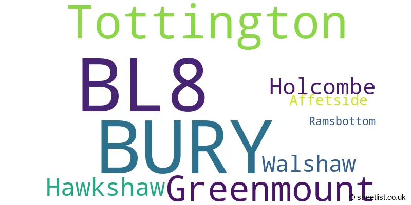
The largest settlement in the BL8 postal code is BURY followed by Tottington, and Greenmount.
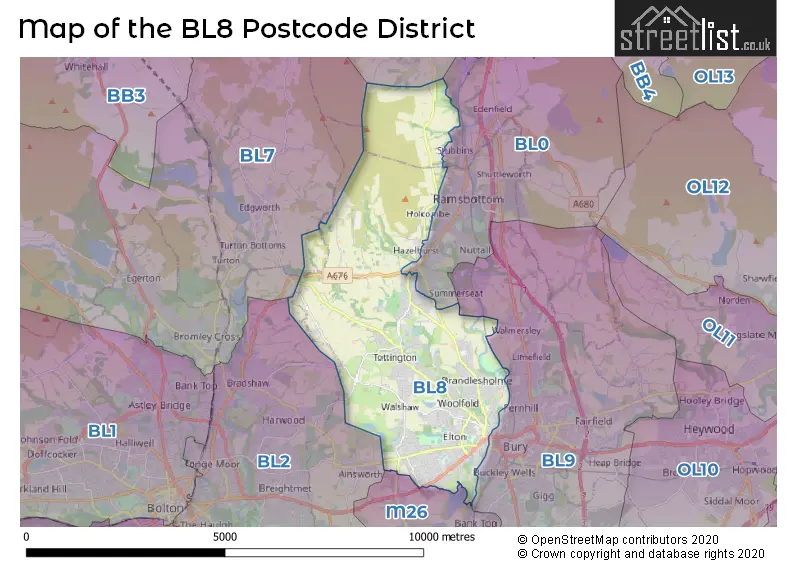
The BL8 Postcode shares a border with M26 (Radcliffe), BL7 (Bromley Cross, Egerton, Turton), BB4 (ROSSENDALE, Haslingden, Rawtenstall) and BL0 (Ramsbottom).
In the BL8 postcode district, the primary settlement is Bury, located in the county of Greater Manchester. Other significant settlements include Affetside, Tottington, and Walshaw. The post town for this district is also Bury.
For the district BL8, we have data on 5 postcode sectors. Here's a breakdown: The sector BL8 1, covers Bury in Greater Manchester. The sector BL8 2, covers Bury in Greater Manchester. The sector BL8 3, covers Tottington and Walshaw and Bury in Greater Manchester. The sector BL8 4, covers Greenmount and Hawkshaw and Tottington and Holcombe in Greater Manchester. The sector BL8 9 is non-geographic. It's often designated for PO Boxes, large organisations, or special services.

Map of the BL8 Postcode District
Explore the BL8 postcode district by using our free interactive map.
When it comes to local government, postal geography often disregards political borders. However, for a breakdown in the BL8 District: the district mostly encompasses the Bury District (B) (1013 postcodes), followed by the Rossendale District (B) area (5 postcodes), and finally, the Blackburn with Darwen (B) area (3 postcodes).
Weather Forecast for BL8
Press Button to Show Forecast for Woolfold
| Time Period | Icon | Description | Temperature | Rain Probability | Wind |
|---|---|---|---|---|---|
| 06:00 to 09:00 | Sunny day | 4.0°C (feels like 2.0°C) | 1.00% | NE 4 mph | |
| 09:00 to 12:00 | Cloudy | 7.0°C (feels like 5.0°C) | 5.00% | E 4 mph | |
| 12:00 to 15:00 | Overcast | 9.0°C (feels like 7.0°C) | 8.00% | E 4 mph | |
| 15:00 to 18:00 | Cloudy | 10.0°C (feels like 9.0°C) | 6.00% | E 4 mph | |
| 18:00 to 21:00 | Cloudy | 9.0°C (feels like 7.0°C) | 6.00% | E 7 mph | |
| 21:00 to 00:00 | Cloudy | 7.0°C (feels like 4.0°C) | 6.00% | ENE 7 mph |
Press Button to Show Forecast for Woolfold
| Time Period | Icon | Description | Temperature | Rain Probability | Wind |
|---|---|---|---|---|---|
| 00:00 to 03:00 | Partly cloudy (night) | 5.0°C (feels like 3.0°C) | 5.00% | ENE 7 mph | |
| 03:00 to 06:00 | Cloudy | 4.0°C (feels like 2.0°C) | 8.00% | ENE 4 mph | |
| 06:00 to 09:00 | Partly cloudy (day) | 5.0°C (feels like 3.0°C) | 5.00% | ENE 7 mph | |
| 09:00 to 12:00 | Cloudy | 7.0°C (feels like 5.0°C) | 8.00% | E 9 mph | |
| 12:00 to 15:00 | Cloudy | 9.0°C (feels like 7.0°C) | 12.00% | E 9 mph | |
| 15:00 to 18:00 | Cloudy | 10.0°C (feels like 8.0°C) | 17.00% | E 9 mph | |
| 18:00 to 21:00 | Cloudy | 9.0°C (feels like 7.0°C) | 16.00% | ENE 9 mph | |
| 21:00 to 00:00 | Cloudy | 8.0°C (feels like 5.0°C) | 17.00% | ENE 9 mph |
Press Button to Show Forecast for Woolfold
| Time Period | Icon | Description | Temperature | Rain Probability | Wind |
|---|---|---|---|---|---|
| 00:00 to 03:00 | Cloudy | 7.0°C (feels like 4.0°C) | 14.00% | ENE 9 mph | |
| 03:00 to 06:00 | Overcast | 7.0°C (feels like 4.0°C) | 23.00% | NE 9 mph | |
| 06:00 to 09:00 | Light rain | 7.0°C (feels like 5.0°C) | 47.00% | NE 9 mph | |
| 09:00 to 12:00 | Overcast | 9.0°C (feels like 6.0°C) | 21.00% | NE 9 mph | |
| 12:00 to 15:00 | Heavy rain | 10.0°C (feels like 8.0°C) | 76.00% | NE 9 mph | |
| 15:00 to 18:00 | Heavy rain | 11.0°C (feels like 9.0°C) | 75.00% | NE 9 mph | |
| 18:00 to 21:00 | Light rain shower (day) | 10.0°C (feels like 8.0°C) | 42.00% | N 9 mph | |
| 21:00 to 00:00 | Partly cloudy (night) | 9.0°C (feels like 7.0°C) | 15.00% | N 7 mph |
Where is the BL8 Postcode District?
The data provided indicates that the postcode district BL8 is located in Bury, a town in the United Kingdom. Bury is in close proximity to various nearby towns in different directions. To the South West, there is Bolton, which is approximately 4.97 miles away. To the South East, the town of Heywood is located about 5.35 miles away. In the North East, there is Rawtenstall, which is around 5.91 miles away. Darwen, a town in the North West, is about 6.29 miles away. The town of Rochdale is situated to the East, approximately 6.5 miles away. Additionally, Accrington, located to the North, is roughly 8.81 miles away. Lastly, Salford, a town to the South, is around 9.44 miles away. It is important to note that the distance from Bury to the center of London is approximately 173.54 miles.
The district is within the post town of BURY.
The sector has postcodes within the nation of England.
The BL8 Postcode District is covers the following regions.
- Greater Manchester North East - Greater Manchester - North West (England)
- Greater Manchester North West - Greater Manchester - North West (England)
- Blackburn with Darwen - Lancashire - North West (England)
- East Lancashire - Lancashire - North West (England)
| Postcode Sector | Delivery Office |
|---|---|
| BL8 1 | Bury Delivery Office |
| BL8 2 | Bury Delivery Office |
| BL8 3 | Bury Delivery Office |
| BL8 4 | Bury Delivery Office |
| B | L | 8 | - | X | X | X |
| B | L | 8 | Space | Numeric | Letter | Letter |
Current Monthly Rental Prices
| # Bedrooms | Min Price | Max Price | Avg Price |
|---|---|---|---|
| 1 | £390 | £950 | £690 |
| 2 | £795 | £1,000 | £899 |
| 3 | £900 | £1,500 | £1,213 |
| 4 | £1,395 | £1,395 | £1,395 |
Current House Prices
| # Bedrooms | Min Price | Max Price | Avg Price |
|---|---|---|---|
| £600,000 | £600,000 | £600,000 | |
| 2 | £600,000 | £600,000 | £600,000 |
| 3 | £300,000 | £650,000 | £523,333 |
| 4 | £595,000 | £1,500,000 | £781,429 |
| 5 | £625,000 | £1,750,000 | £986,500 |
| 6 | £690,000 | £690,000 | £690,000 |
Estate Agents who Operate in the BL8 District
| Logo | Name | Brand Name | Address | Contact Number | Total Properties |
|---|---|---|---|---|---|
 | Bury | Miller Metcalfe | 9-11 Market Street, Bury, BL9 0AH | 0161 524 6920 | 53 |
 | Bury | Kristian Allan | Stoneholme, 42 High Street, Walshaw, Bury, BL8 3AN | 01204 958022 | 24 |
 | Bury | Entwistle Green | 10 The Rock Bury BL9 0NT | 0161 524 3592 | 21 |
 | Bury | Pearson Ferrier | 435 - 437 Walmersley Road, Bury, BL9 5EU | 0161 524 8716 | 16 |
 | Bury | Keenans Estate Agents | 2 The Rock, Bury, BL9 0NT | 0161 524 7344 | 14 |
| Type of Property | 2018 Average | 2018 Sales | 2017 Average | 2017 Sales | 2016 Average | 2016 Sales | 2015 Average | 2015 Sales |
|---|---|---|---|---|---|---|---|---|
| Detached | £328,257 | 157 | £294,132 | 152 | £283,921 | 195 | £271,875 | 180 |
| Semi-Detached | £182,068 | 198 | £168,792 | 198 | £164,261 | 196 | £157,648 | 204 |
| Terraced | £136,773 | 232 | £125,592 | 221 | £121,453 | 222 | £117,798 | 211 |
| Flats | £120,493 | 23 | £106,010 | 24 | £143,179 | 19 | £127,389 | 18 |