The BL7 postcode district is a postal district located in the BL Bolton postcode area with a population of 15,174 residents according to the 2021 England and Wales Census.
The area of the BL7 postcode district is 24.46 square miles which is 63.35 square kilometres or 15,653.87 acres.
Currently, the BL7 district has about 506 postcode units spread across 3 geographic postcode sectors.
Given that each sector allows for 400 unique postcode combinations, the district has a capacity of 1,200 postcodes. With 506 postcodes already in use, this leaves 694 units available.
The largest settlement in the BL7 postal code is Bromley Cross followed by Egerton, and Turton.
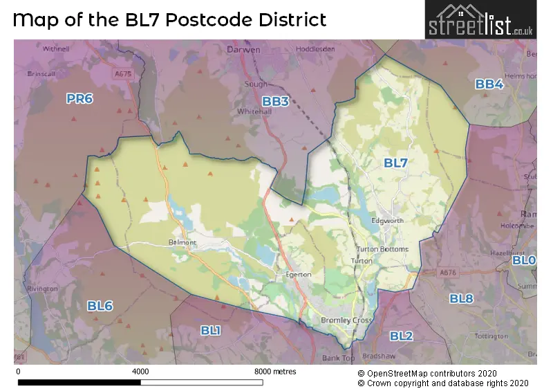
The BL7 Postcode shares a border with PR6 (CHORLEY, Whittle-le-Woods, Clayton-le-Woods), BL2 (BOLTON, Ainsworth, Bradley Fold), BL1 (BOLTON), BL8 (BURY, Tottington, Greenmount) and BB3 (DARWEN, Lower Darwen, Hoddlesden).
The primary settlement in the BL7 postcode district is Turton, located in the county of Lancashire in Greater Manchester. Other significant settlements include Belmont, Bromley Cross, and Egerton. The most significant post town in the district is Bolton, also located in Greater Manchester.
For the district BL7, we have data on 3 postcode sectors. Here's a breakdown: The sector BL7 0, covers Turton in Lancashire. The sector BL7 8, covers Belmont in Lancashire. The sector BL7 9, covers Bromley Cross and Egerton in Greater Manchester.

Map of the BL7 Postcode District
Explore the BL7 postcode district by using our free interactive map.
When it comes to local government, postal geography often disregards political borders. However, for a breakdown in the BL7 District: the district mostly encompasses the Bolton District (B) (295 postcodes), and finally, the Blackburn with Darwen (B) area (213 postcodes).
Weather Forecast for BL7
Press Button to Show Forecast for Bromley Cross
| Time Period | Icon | Description | Temperature | Rain Probability | Wind |
|---|---|---|---|---|---|
| 06:00 to 09:00 | Partly cloudy (day) | 4.0°C (feels like 1.0°C) | 2.00% | NE 7 mph | |
| 09:00 to 12:00 | Cloudy | 8.0°C (feels like 5.0°C) | 9.00% | E 9 mph | |
| 12:00 to 15:00 | Cloudy | 9.0°C (feels like 6.0°C) | 9.00% | ENE 11 mph | |
| 15:00 to 18:00 | Overcast | 9.0°C (feels like 7.0°C) | 17.00% | ENE 9 mph | |
| 18:00 to 21:00 | Cloudy | 8.0°C (feels like 6.0°C) | 13.00% | ENE 9 mph | |
| 21:00 to 00:00 | Cloudy | 6.0°C (feels like 4.0°C) | 5.00% | NE 7 mph |
Press Button to Show Forecast for Bromley Cross
| Time Period | Icon | Description | Temperature | Rain Probability | Wind |
|---|---|---|---|---|---|
| 00:00 to 03:00 | Cloudy | 5.0°C (feels like 3.0°C) | 4.00% | NE 7 mph | |
| 03:00 to 06:00 | Cloudy | 5.0°C (feels like 2.0°C) | 5.00% | NNE 9 mph | |
| 06:00 to 09:00 | Cloudy | 5.0°C (feels like 2.0°C) | 13.00% | N 7 mph | |
| 09:00 to 12:00 | Overcast | 7.0°C (feels like 4.0°C) | 16.00% | NNW 9 mph | |
| 12:00 to 15:00 | Overcast | 9.0°C (feels like 7.0°C) | 18.00% | NW 9 mph | |
| 15:00 to 18:00 | Cloudy | 10.0°C (feels like 7.0°C) | 14.00% | WNW 11 mph | |
| 18:00 to 21:00 | Sunny day | 9.0°C (feels like 7.0°C) | 5.00% | W 9 mph | |
| 21:00 to 00:00 | Clear night | 7.0°C (feels like 5.0°C) | 3.00% | WSW 7 mph |
Press Button to Show Forecast for Bromley Cross
| Time Period | Icon | Description | Temperature | Rain Probability | Wind |
|---|---|---|---|---|---|
| 00:00 to 03:00 | Partly cloudy (night) | 6.0°C (feels like 4.0°C) | 2.00% | SSW 7 mph | |
| 03:00 to 06:00 | Clear night | 4.0°C (feels like 2.0°C) | 3.00% | SSE 7 mph | |
| 06:00 to 09:00 | Cloudy | 5.0°C (feels like 2.0°C) | 9.00% | SSE 7 mph | |
| 09:00 to 12:00 | Cloudy | 9.0°C (feels like 7.0°C) | 8.00% | S 11 mph | |
| 12:00 to 15:00 | Overcast | 12.0°C (feels like 9.0°C) | 11.00% | S 13 mph | |
| 15:00 to 18:00 | Cloudy | 13.0°C (feels like 10.0°C) | 10.00% | S 13 mph | |
| 18:00 to 21:00 | Partly cloudy (day) | 12.0°C (feels like 10.0°C) | 8.00% | SSE 11 mph | |
| 21:00 to 00:00 | Clear night | 10.0°C (feels like 8.0°C) | 5.00% | SSE 9 mph |
Press Button to Show Forecast for Bromley Cross
| Time Period | Icon | Description | Temperature | Rain Probability | Wind |
|---|---|---|---|---|---|
| 00:00 to 03:00 | Clear night | 9.0°C (feels like 6.0°C) | 4.00% | SE 9 mph | |
| 03:00 to 06:00 | Partly cloudy (night) | 8.0°C (feels like 5.0°C) | 2.00% | SE 9 mph | |
| 06:00 to 09:00 | Partly cloudy (day) | 8.0°C (feels like 6.0°C) | 3.00% | ESE 9 mph | |
| 09:00 to 12:00 | Sunny day | 12.0°C (feels like 9.0°C) | 4.00% | ESE 11 mph | |
| 12:00 to 15:00 | Partly cloudy (day) | 14.0°C (feels like 12.0°C) | 6.00% | SE 13 mph | |
| 15:00 to 18:00 | Cloudy | 16.0°C (feels like 13.0°C) | 11.00% | SE 11 mph | |
| 18:00 to 21:00 | Partly cloudy (day) | 15.0°C (feels like 13.0°C) | 7.00% | ESE 11 mph | |
| 21:00 to 00:00 | Cloudy | 12.0°C (feels like 11.0°C) | 8.00% | E 9 mph |
Where is the BL7 Postcode District?
The data indicates that the postcode district BL7 is located in Bolton, a town in the United Kingdom. Bolton is situated near several other towns: Darwen to the north (2.56 miles away), Bury to the south east (6.76 miles away), Rossendale to the north east (7.33 miles away), Chorley to the west (8.16 miles away), and Bacup to the east (10.43 miles away). Additionally, the distance between Bolton and the center of London is approximately 177.2 miles.
The district is within the post town of BOLTON.
The sector has postcodes within the nation of England.
The BL7 Postcode District is covers the following regions.
- Blackburn with Darwen - Lancashire - North West (England)
- Greater Manchester North West - Greater Manchester - North West (England)
| Postcode Sector | Delivery Office |
|---|---|
| BL7 0 | Bolton North Delivery Office |
| BL7 8 | Belmont Scale Payment Delivery Office |
| BL7 9 | Bolton North Delivery Office |
| B | L | 7 | - | X | X | X |
| B | L | 7 | Space | Numeric | Letter | Letter |
Current Monthly Rental Prices
| # Bedrooms | Min Price | Max Price | Avg Price |
|---|---|---|---|
| 2 | £825 | £1,050 | £957 |
| 3 | £995 | £1,100 | £1,048 |
| 4 | £1,400 | £2,200 | £1,800 |
Current House Prices
| # Bedrooms | Min Price | Max Price | Avg Price |
|---|---|---|---|
| £650,000 | £650,000 | £650,000 | |
| 2 | £640,000 | £640,000 | £640,000 |
| 3 | £595,000 | £899,950 | £682,488 |
| 4 | £550,000 | £1,100,000 | £735,321 |
| 5 | £735,000 | £775,000 | £755,000 |
| 6 | £550,000 | £1,000,000 | £775,000 |
| 7 | £1,200,000 | £1,200,000 | £1,200,000 |
Estate Agents who Operate in the BL7 District
| Logo | Name | Brand Name | Address | Contact Number | Total Properties |
|---|---|---|---|---|---|
 | Bolton | Claves | Claves House, 295D Darwen Road, Bromley Cross, Bolton, BL7 9BT | 01204 958267 | 26 |
 | Bolton | William Thomas Estate Agency | 454 Darwen Road, Bromley Cross, Bolton, BL7 9DX | 01204 326755 | 25 |
 | Harwood | Miller Metcalfe | 87a Lea Gate, Harwood, Bolton, BL2 4BQ | 01202 145374 | 17 |
 | Bolton | Newton & Co Ltd | 6th Floor 120 Bark Street Bolton Greater Manchester BL1 2AX | 01204 952881 | 13 |
 | Bolton | Cardwells Sales, Lettings, Management & Commercial | 11 Institute Street, Bolton, BL1 1PZ | 01204 326664 | 10 |
| Type of Property | 2018 Average | 2018 Sales | 2017 Average | 2017 Sales | 2016 Average | 2016 Sales | 2015 Average | 2015 Sales |
|---|---|---|---|---|---|---|---|---|
| Detached | £378,123 | 101 | £334,936 | 130 | £350,567 | 99 | £320,664 | 107 |
| Semi-Detached | £196,816 | 68 | £182,054 | 61 | £201,064 | 64 | £185,855 | 60 |
| Terraced | £172,072 | 137 | £177,505 | 91 | £157,425 | 105 | £171,136 | 140 |
| Flats | £154,583 | 27 | £147,140 | 25 | £136,181 | 19 | £127,188 | 21 |