The BL9 postcode district is a postal district located in the BL Bolton postcode area with a population of 52,307 residents according to the 2021 England and Wales Census.
The area of the BL9 postcode district is 13.71 square miles which is 35.51 square kilometres or 8,773.68 acres.
Currently, the BL9 district has about 1308 postcode units spread across 6 geographic postcode sectors.
Given that each sector allows for 400 unique postcode combinations, the district has a capacity of 2,400 postcodes. With 1308 postcodes already in use, this leaves 1092 units available.
The BL9 postal code covers the settlement of BURY.
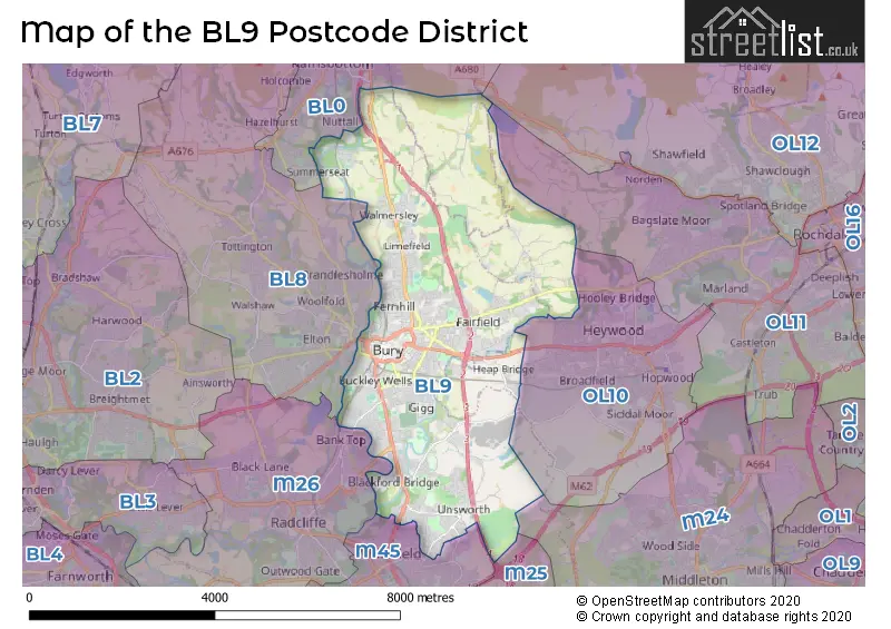
The BL9 Postcode shares a border with OL10 (HEYWOOD), M26 (Radcliffe), M45 (Whitefield) and BL0 (Ramsbottom).
The primary settlement in the BL9 postcode district is Bury, which is located in the county of Greater Manchester, England. Other significant settlements include Summerseat and Walmersley, also located in Greater Manchester. The most significant post town in the BL9 postcode district is Bury.
For the district BL9, we have data on 6 postcode sectors. Here's a breakdown: The sector BL9 0, covers Bury in Greater Manchester. The sector BL9 5, covers Bury in Greater Manchester. The sector BL9 6, covers Bury in Greater Manchester. The sector BL9 7, covers Bury in Greater Manchester. The sector BL9 8, covers Bury in Greater Manchester. The sector BL9 9, covers Bury in Greater Manchester.

Map of the BL9 Postcode District
Explore the BL9 postcode district by using our free interactive map.
When it comes to local government, postal geography often disregards political borders. However, for a breakdown in the BL9 District: the district mostly encompasses the Bury District (B) (1244 postcodes), followed by the Rochdale District (B) area (63 postcodes), and finally, the Rossendale District (B) area (8 postcodes).
Weather Forecast for BL9
Press Button to Show Forecast for Free Town
| Time Period | Icon | Description | Temperature | Rain Probability | Wind |
|---|---|---|---|---|---|
| 09:00 to 12:00 | Cloudy | 8.0°C (feels like 5.0°C) | 4.00% | ENE 9 mph | |
| 12:00 to 15:00 | Cloudy | 10.0°C (feels like 7.0°C) | 6.00% | ENE 9 mph | |
| 15:00 to 18:00 | Cloudy | 9.0°C (feels like 6.0°C) | 47.00% | ENE 11 mph | |
| 18:00 to 21:00 | Cloudy | 8.0°C (feels like 6.0°C) | 14.00% | ENE 9 mph | |
| 21:00 to 00:00 | Cloudy | 7.0°C (feels like 4.0°C) | 4.00% | NE 9 mph |
Press Button to Show Forecast for Free Town
| Time Period | Icon | Description | Temperature | Rain Probability | Wind |
|---|---|---|---|---|---|
| 00:00 to 03:00 | Cloudy | 6.0°C (feels like 3.0°C) | 4.00% | NE 9 mph | |
| 03:00 to 06:00 | Cloudy | 5.0°C (feels like 2.0°C) | 5.00% | NNE 9 mph | |
| 06:00 to 09:00 | Cloudy | 6.0°C (feels like 3.0°C) | 13.00% | N 9 mph | |
| 09:00 to 12:00 | Light rain | 7.0°C (feels like 5.0°C) | 44.00% | NNW 7 mph | |
| 12:00 to 15:00 | Light rain | 9.0°C (feels like 7.0°C) | 46.00% | NW 9 mph | |
| 15:00 to 18:00 | Cloudy | 10.0°C (feels like 8.0°C) | 15.00% | WNW 11 mph | |
| 18:00 to 21:00 | Partly cloudy (day) | 10.0°C (feels like 8.0°C) | 5.00% | W 9 mph | |
| 21:00 to 00:00 | Clear night | 7.0°C (feels like 5.0°C) | 3.00% | SW 7 mph |
Press Button to Show Forecast for Free Town
| Time Period | Icon | Description | Temperature | Rain Probability | Wind |
|---|---|---|---|---|---|
| 00:00 to 03:00 | Clear night | 6.0°C (feels like 4.0°C) | 1.00% | S 7 mph | |
| 03:00 to 06:00 | Clear night | 4.0°C (feels like 2.0°C) | 3.00% | SSE 7 mph | |
| 06:00 to 09:00 | Partly cloudy (day) | 6.0°C (feels like 3.0°C) | 4.00% | SSE 7 mph | |
| 09:00 to 12:00 | Partly cloudy (day) | 10.0°C (feels like 7.0°C) | 3.00% | S 11 mph | |
| 12:00 to 15:00 | Overcast | 13.0°C (feels like 10.0°C) | 11.00% | S 13 mph | |
| 15:00 to 18:00 | Overcast | 13.0°C (feels like 11.0°C) | 12.00% | S 13 mph | |
| 18:00 to 21:00 | Partly cloudy (day) | 13.0°C (feels like 10.0°C) | 8.00% | S 11 mph | |
| 21:00 to 00:00 | Clear night | 11.0°C (feels like 9.0°C) | 5.00% | SSE 9 mph |
Press Button to Show Forecast for Free Town
| Time Period | Icon | Description | Temperature | Rain Probability | Wind |
|---|---|---|---|---|---|
| 00:00 to 03:00 | Clear night | 9.0°C (feels like 7.0°C) | 4.00% | SE 9 mph | |
| 03:00 to 06:00 | Partly cloudy (night) | 8.0°C (feels like 6.0°C) | 3.00% | SE 9 mph | |
| 06:00 to 09:00 | Partly cloudy (day) | 9.0°C (feels like 6.0°C) | 3.00% | ESE 9 mph | |
| 09:00 to 12:00 | Sunny day | 12.0°C (feels like 10.0°C) | 4.00% | ESE 11 mph | |
| 12:00 to 15:00 | Cloudy | 15.0°C (feels like 12.0°C) | 9.00% | SE 13 mph | |
| 15:00 to 18:00 | Cloudy | 16.0°C (feels like 13.0°C) | 11.00% | SE 11 mph | |
| 18:00 to 21:00 | Cloudy | 15.0°C (feels like 13.0°C) | 10.00% | ESE 11 mph | |
| 21:00 to 00:00 | Cloudy | 13.0°C (feels like 11.0°C) | 8.00% | E 9 mph |
Where is the BL9 Postcode District?
The postcode district BL9 is located in Bury, a town in Greater Manchester. It is surrounded by several nearby towns, including Heywood to the South East, Rochdale to the East, Bolton to the West, Rossendale to the North, Salford to the South, Bacup to the North East, and Darwen to the North West. Additionally, the distance from this postcode district to London is approximately 170.719 miles.
The district is within the post town of BURY.
The sector has postcodes within the nation of England.
The BL9 Postcode District is covers the following regions.
- Greater Manchester North East - Greater Manchester - North West (England)
- East Lancashire - Lancashire - North West (England)
| Postcode Sector | Delivery Office |
|---|---|
| BL9 0 | Bury Delivery Office |
| BL9 5 | Bury Delivery Office |
| BL9 6 | Bury Delivery Office |
| BL9 7 | Bury Delivery Office |
| BL9 8 | Bury Delivery Office |
| BL9 9 | Bury Delivery Office |
| B | L | 9 | - | X | X | X |
| B | L | 9 | Space | Numeric | Letter | Letter |
Tourist Attractions within the Postcode Area
We found 1 visitor attractions within the BL9 postcode area
| Bury Art Museum |
|---|
| Museums & Art Galleries |
| Museum and / or Art Gallery |
| View Bury Art Museum on Google Maps |
Current Monthly Rental Prices
| # Bedrooms | Min Price | Max Price | Avg Price |
|---|---|---|---|
| £695 | £1,000 | £848 | |
| 1 | £495 | £825 | £660 |
| 2 | £750 | £895 | £819 |
| 3 | £875 | £1,300 | £1,092 |
| 4 | £1,350 | £1,700 | £1,525 |
| 6 | £495 | £640 | £582 |
| 8 | £600 | £610 | £605 |
Current House Prices
| # Bedrooms | Min Price | Max Price | Avg Price |
|---|---|---|---|
| £600,000 | £700,000 | £650,000 | |
| 3 | £590,000 | £590,000 | £590,000 |
| 4 | £525,000 | £1,200,000 | £696,000 |
| 5 | £575,000 | £900,000 | £790,000 |
| 6 | £570,000 | £600,000 | £585,000 |
| 7 | £1,450,000 | £1,450,000 | £1,450,000 |
| 20 | £750,000 | £750,000 | £750,000 |
Estate Agents who Operate in the BL9 District
| Logo | Name | Brand Name | Address | Contact Number | Total Properties |
|---|---|---|---|---|---|
 | Bury | Pearson Ferrier | 435 - 437 Walmersley Road, Bury, BL9 5EU | 0161 524 8716 | 42 |
 | Prestwich | Normie Sales & Lettings | 503-505 Bury New Road, Prestwich, Manchester M25 1AD | 020 3834 7844 | 31 |
 | Bury | Miller Metcalfe | 9-11 Market Street, Bury, BL9 0AH | 0161 524 6920 | 24 |
 | Bury | Entwistle Green | 10 The Rock Bury BL9 0NT | 0161 524 3592 | 18 |
 | Bury | Keenans Estate Agents | 2 The Rock, Bury, BL9 0NT | 0161 524 7344 | 16 |
| Type of Property | 2018 Average | 2018 Sales | 2017 Average | 2017 Sales | 2016 Average | 2016 Sales | 2015 Average | 2015 Sales |
|---|---|---|---|---|---|---|---|---|
| Detached | £284,737 | 89 | £282,739 | 102 | £243,434 | 140 | £228,638 | 94 |
| Semi-Detached | £163,173 | 242 | £153,673 | 245 | £147,669 | 237 | £148,640 | 241 |
| Terraced | £116,638 | 336 | £116,789 | 341 | £102,012 | 315 | £99,975 | 329 |
| Flats | £100,547 | 73 | £99,076 | 78 | £87,509 | 66 | £103,017 | 71 |