The RH17 5 postcode sector is within the county of West Sussex.
Did you know? According to the 2021 Census, the RH17 5 postcode sector is home to a bustling 7,270 residents!
Given that each sector allows for 400 unique postcode combinations. Letters C, I, K, M, O and V are not allowed in the last two letters of a postcode. With 249 postcodes already in use, this leaves 151 units available.
The largest settlement in the RH17 5 postal code is Cuckfield followed by Bolney, and Warninglid.
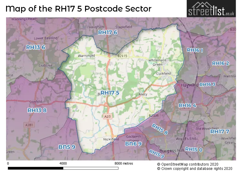
The RH17 5 Postcode shares a border with RH15 8 (BURGESS HILL), RH16 1 (HAYWARDS HEATH, Lindfield), RH16 4 (HAYWARDS HEATH), RH13 6 (HORSHAM, Mannings Heath, Lower Beeding), RH13 8 (Partridge Green, Cowfold, Shipley), RH17 6 (Balcombe, Ardingly, Handcross), BN5 9 (HENFIELD, Small Dole, Woodmancote) and BN6 9 (Hurstpierpoint, Sayers Common, HASSOCKS).
The sector is within the post town of HAYWARDS HEATH.
RH17 5 is a postcode sector within the RH17 postcode district which is within the BN Brighton postcode area.
The Royal Mail delivery office for the RH17 5 postal sector is the Haywards Heath Delivery Office.
The area of the RH17 5 postcode sector is 20.29 square miles which is 52.55 square kilometres or 12,984.28 square acres.
The RH17 5 postcode sector is crossed by the A23 Major A road.

Map of the RH17 5 Postcode Sector
Explore the RH17 5 postcode sector by using our free interactive map.
| R | H | 1 | 7 | - | 5 | X | X |
| R | H | 1 | 7 | Space | 5 | Letter | Letter |
Official List of Streets
Cuckfield (68 Streets)
HAYWARDS HEATH (9 Streets)
Bolney (30 Streets)
Ansty (10 Streets)
Twineham (5 Streets)
Warninglid (15 Streets)
Hickstead (3 Streets)
Unofficial Streets or Alternative Spellings
Sayers Common
DUMBRELLS FARM WAY POOKBOURNE LANEAlbourne
LONDON ROAD TWINEHAM LANEStaplefield
CUCKFIELD ROAD STAPLEFIELD LANEBalcombe
LONDON ROADCowfold
LONG HOUSE LANEWeather Forecast for RH17 5
Press Button to Show Forecast for Leonardslee Gardens
| Time Period | Icon | Description | Temperature | Rain Probability | Wind |
|---|---|---|---|---|---|
| 15:00 to 18:00 | Sunny day | 23.0°C (feels like 21.0°C) | 0.00% | SE 9 mph | |
| 18:00 to 21:00 | Sunny day | 21.0°C (feels like 19.0°C) | 0.00% | E 9 mph | |
| 21:00 to 00:00 | Clear night | 16.0°C (feels like 14.0°C) | 0.00% | ENE 11 mph |
Press Button to Show Forecast for Leonardslee Gardens
| Time Period | Icon | Description | Temperature | Rain Probability | Wind |
|---|---|---|---|---|---|
| 00:00 to 03:00 | Partly cloudy (night) | 15.0°C (feels like 13.0°C) | 1.00% | ENE 9 mph | |
| 03:00 to 06:00 | Cloudy | 14.0°C (feels like 13.0°C) | 3.00% | E 9 mph | |
| 06:00 to 09:00 | Cloudy | 15.0°C (feels like 14.0°C) | 4.00% | E 7 mph | |
| 09:00 to 12:00 | Partly cloudy (day) | 20.0°C (feels like 18.0°C) | 0.00% | ESE 9 mph | |
| 12:00 to 15:00 | Partly cloudy (day) | 23.0°C (feels like 22.0°C) | 2.00% | SE 9 mph | |
| 15:00 to 18:00 | Cloudy | 22.0°C (feels like 21.0°C) | 4.00% | S 7 mph | |
| 18:00 to 21:00 | Cloudy | 18.0°C (feels like 17.0°C) | 6.00% | S 9 mph | |
| 21:00 to 00:00 | Cloudy | 14.0°C (feels like 13.0°C) | 18.00% | SSW 7 mph |
Press Button to Show Forecast for Leonardslee Gardens
| Time Period | Icon | Description | Temperature | Rain Probability | Wind |
|---|---|---|---|---|---|
| 00:00 to 03:00 | Cloudy | 13.0°C (feels like 12.0°C) | 18.00% | SSW 7 mph | |
| 03:00 to 06:00 | Overcast | 12.0°C (feels like 11.0°C) | 14.00% | SSW 7 mph | |
| 06:00 to 09:00 | Overcast | 13.0°C (feels like 11.0°C) | 13.00% | SSW 9 mph | |
| 09:00 to 12:00 | Overcast | 14.0°C (feels like 12.0°C) | 16.00% | S 11 mph | |
| 12:00 to 15:00 | Cloudy | 16.0°C (feels like 13.0°C) | 15.00% | S 16 mph | |
| 15:00 to 18:00 | Light rain | 17.0°C (feels like 14.0°C) | 51.00% | SSE 13 mph | |
| 18:00 to 21:00 | Heavy rain | 15.0°C (feels like 13.0°C) | 79.00% | SSE 11 mph | |
| 21:00 to 00:00 | Heavy rain | 14.0°C (feels like 12.0°C) | 86.00% | SSE 11 mph |
Press Button to Show Forecast for Leonardslee Gardens
| Time Period | Icon | Description | Temperature | Rain Probability | Wind |
|---|---|---|---|---|---|
| 00:00 to 03:00 | Heavy rain | 14.0°C (feels like 12.0°C) | 85.00% | SSE 11 mph | |
| 03:00 to 06:00 | Heavy rain | 13.0°C (feels like 12.0°C) | 82.00% | S 7 mph | |
| 06:00 to 09:00 | Light rain | 13.0°C (feels like 11.0°C) | 61.00% | S 9 mph | |
| 09:00 to 12:00 | Heavy rain | 14.0°C (feels like 12.0°C) | 76.00% | S 13 mph | |
| 12:00 to 15:00 | Light rain shower (day) | 15.0°C (feels like 13.0°C) | 41.00% | S 16 mph | |
| 15:00 to 18:00 | Light rain shower (day) | 16.0°C (feels like 13.0°C) | 32.00% | S 13 mph | |
| 18:00 to 21:00 | Light rain shower (day) | 15.0°C (feels like 13.0°C) | 31.00% | S 11 mph | |
| 21:00 to 00:00 | Partly cloudy (night) | 13.0°C (feels like 11.0°C) | 6.00% | SSE 9 mph |
Press Button to Show Forecast for Leonardslee Gardens
| Time Period | Icon | Description | Temperature | Rain Probability | Wind |
|---|---|---|---|---|---|
| 00:00 to 03:00 | Cloudy | 12.0°C (feels like 10.0°C) | 8.00% | S 9 mph | |
| 03:00 to 06:00 | Partly cloudy (night) | 11.0°C (feels like 10.0°C) | 7.00% | S 9 mph | |
| 06:00 to 09:00 | Cloudy | 12.0°C (feels like 10.0°C) | 11.00% | S 9 mph | |
| 09:00 to 12:00 | Light rain shower (day) | 14.0°C (feels like 11.0°C) | 35.00% | S 13 mph | |
| 12:00 to 15:00 | Light rain shower (day) | 15.0°C (feels like 12.0°C) | 31.00% | S 13 mph | |
| 15:00 to 18:00 | Light rain shower (day) | 16.0°C (feels like 13.0°C) | 28.00% | S 13 mph | |
| 18:00 to 21:00 | Light rain shower (day) | 15.0°C (feels like 13.0°C) | 28.00% | S 9 mph | |
| 21:00 to 00:00 | Clear night | 12.0°C (feels like 11.0°C) | 2.00% | SSE 7 mph |
Schools and Places of Education Within the RH17 5 Postcode Sector
Bolney CofE Primary School
Voluntary controlled school
Church Lane, Haywards Heath, West Sussex, RH17 5QP
Head: Ms Emma Lofthouse
Ofsted Rating: Good
Inspection: 2019-07-05 (1772 days ago)
Website: Visit Bolney CofE Primary School Website
Phone: 01444881352
Number of Pupils: 101
Farney Close School
Other independent special school
Bolney Court, Haywards Heath, West Sussex, RH17 5RD
Head: Mrs Sara Hack
Ofsted Rating: Good
Inspection: 2022-10-06 (583 days ago)
Website: Visit Farney Close School Website
Phone: 01444881811
Number of Pupils: 60
Holy Trinity CofE Primary School, Cuckfield
Voluntary aided school
Glebe Road, Haywards Heath, West Sussex, RH17 5BQ
Head: Mrs Ann MacGregor
Ofsted Rating: Good
Inspection: 2023-10-18 (206 days ago)
Website: Visit Holy Trinity CofE Primary School, Cuckfield Website
Phone: 07469990127
Number of Pupils: 417
Twineham CofE Primary School
Voluntary controlled school
Church Lane, Haywards Heath, Avon, RH17 5NR
Head: Mrs Sarah Davy
Ofsted Rating: Good
Inspection: 2022-11-17 (541 days ago)
Website: Visit Twineham CofE Primary School Website
Phone: 01444881207
Number of Pupils: 68
Warden Park Secondary Academy
Academy converter
Broad Street, Haywards Heath, West Sussex, RH17 5DP
Head: Mr Dom Kenrick
Ofsted Rating: Good
Inspection: 2022-02-16 (815 days ago)
Website: Visit Warden Park Secondary Academy Website
Phone: 01444457881
Number of Pupils: 1523
House Prices in the RH17 5 Postcode Sector
| Type of Property | 2018 Average | 2018 Sales | 2017 Average | 2017 Sales | 2016 Average | 2016 Sales | 2015 Average | 2015 Sales |
|---|---|---|---|---|---|---|---|---|
| Detached | £816,217 | 67 | £852,633 | 58 | £737,339 | 54 | £714,290 | 47 |
| Semi-Detached | £482,448 | 29 | £463,614 | 22 | £446,798 | 36 | £395,348 | 28 |
| Terraced | £411,244 | 8 | £389,096 | 12 | £371,480 | 19 | £363,687 | 12 |
| Flats | £202,821 | 7 | £220,000 | 6 | £209,029 | 14 | £220,367 | 15 |
Important Postcodes RH17 5 in the Postcode Sector
RH17 5BE is the postcode for Holy Trinity C.E.(A) Primary School, Glebe Road
RH17 5BQ is the postcode for Cuckfield Medical Practice, Glebe Road
RH17 5DP is the postcode for MAIN BUILDING, Warden Park School, Broad Street, Warden Park School, Broad Street, FERGUSON BUILDING, Warden Park School, Broad Street, and HISTORY BLOCK, Warden Park School, Broad Street
RH17 5HN is the postcode for Orchard House, Hanlye Lane
RH17 5NR is the postcode for Twineham C of E Primary School, Church Lane
RH17 5QP is the postcode for Bolney C of E Primary School, The Street
RH17 5TJ is the postcode for Warninglid Primary School, Slaugham Lane
| The RH17 5 Sector is within these Local Authorities |
|
|---|---|
| The RH17 5 Sector is within these Counties |
|
| The RH17 5 Sector is within these Water Company Areas |
|