The RH13 6 postcode sector is within the county of West Sussex.
Did you know? According to the 2021 Census, the RH13 6 postcode sector is home to a bustling 8,312 residents!
Given that each sector allows for 400 unique postcode combinations. Letters C, I, K, M, O and V are not allowed in the last two letters of a postcode. With 239 postcodes already in use, this leaves 161 units available.
The largest settlement in the RH13 6 postal code is HORSHAM followed by Mannings Heath, and Lower Beeding.
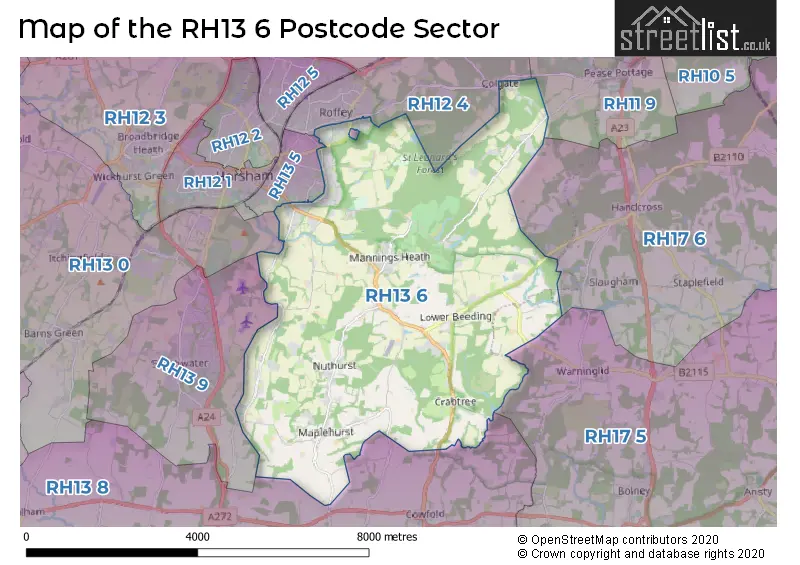
The RH13 6 Postcode shares a border with RH11 9 (CRAWLEY, Pease Pottage, Broadfield), RH13 5 (HORSHAM), RH12 4 (HORSHAM, Faygate, Rusper), RH13 0 (Slinfold, Barns Green, Christs Hospital), RH13 8 (Partridge Green, Cowfold, Shipley), RH13 9 (Southwater, HORSHAM), RH17 5 (Cuckfield, Bolney, Warninglid) and RH17 6 (Balcombe, Ardingly, Handcross).
The sector is within the post town of HORSHAM.
RH13 6 is a postcode sector within the RH13 postcode district which is within the RH Redhill postcode area.
The Royal Mail delivery office for the RH13 6 postal sector is the Horsham Delivery Office.
The area of the RH13 6 postcode sector is 18.09 square miles which is 46.85 square kilometres or 11,577.25 square acres.
Waterways within the RH13 6 postcode sector include the arun.

Map of the RH13 6 Postcode Sector
Explore the RH13 6 postcode sector by using our free interactive map.
| R | H | 1 | 3 | - | 6 | X | X |
| R | H | 1 | 3 | Space | 6 | Letter | Letter |
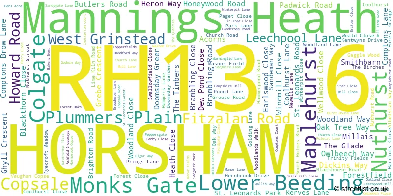
Official List of Streets
HORSHAM (67 Streets)
Colgate (3 Streets)
Plummers Plain (8 Streets)
Lower Beeding (11 Streets)
Mannings Heath (22 Streets)
Monks Gate (4 Streets)
Copsale (3 Streets)
Maplehurst (4 Streets)
Nuthurst (2 Streets)
West Grinstead (1 Streets)
Unofficial Streets or Alternative Spellings
Colgate
FOREST ROADHORSHAM
CHESTERTON COURT COLTSTAPLE LANE COMPTONS COURT DEPOT ROAD HARWOOD ROAD PLOVERS ROAD POLLARDS DRIVE RUTHERFORD WAYHandcross
CARTERSLODGE LANE HORSHAM ROADPlummers Plain
BAKERS MEWSWarninglid
WARNINGLID LANESouthwater
BAR LANEWeather Forecast for RH13 6
Press Button to Show Forecast for Leonardslee Gardens
| Time Period | Icon | Description | Temperature | Rain Probability | Wind |
|---|---|---|---|---|---|
| 09:00 to 12:00 | Cloudy | 10.0°C (feels like 8.0°C) | 6.00% | ENE 7 mph | |
| 12:00 to 15:00 | Cloudy | 12.0°C (feels like 11.0°C) | 9.00% | ESE 7 mph | |
| 15:00 to 18:00 | Cloudy | 12.0°C (feels like 11.0°C) | 19.00% | NE 7 mph | |
| 18:00 to 21:00 | Heavy rain | 11.0°C (feels like 9.0°C) | 90.00% | NE 9 mph | |
| 21:00 to 00:00 | Heavy rain | 10.0°C (feels like 7.0°C) | 91.00% | NE 11 mph |
Press Button to Show Forecast for Leonardslee Gardens
| Time Period | Icon | Description | Temperature | Rain Probability | Wind |
|---|---|---|---|---|---|
| 00:00 to 03:00 | Heavy rain | 9.0°C (feels like 7.0°C) | 87.00% | NE 9 mph | |
| 03:00 to 06:00 | Heavy rain | 9.0°C (feels like 7.0°C) | 92.00% | ENE 9 mph | |
| 06:00 to 09:00 | Light rain | 9.0°C (feels like 7.0°C) | 56.00% | SW 7 mph | |
| 09:00 to 12:00 | Heavy rain | 9.0°C (feels like 6.0°C) | 84.00% | NW 11 mph | |
| 12:00 to 15:00 | Light rain | 9.0°C (feels like 7.0°C) | 50.00% | WSW 13 mph | |
| 15:00 to 18:00 | Cloudy | 11.0°C (feels like 8.0°C) | 13.00% | WSW 11 mph | |
| 18:00 to 21:00 | Cloudy | 10.0°C (feels like 8.0°C) | 15.00% | WSW 9 mph | |
| 21:00 to 00:00 | Clear night | 8.0°C (feels like 6.0°C) | 2.00% | S 7 mph |
Press Button to Show Forecast for Leonardslee Gardens
| Time Period | Icon | Description | Temperature | Rain Probability | Wind |
|---|---|---|---|---|---|
| 00:00 to 03:00 | Clear night | 6.0°C (feels like 5.0°C) | 1.00% | SSW 4 mph | |
| 03:00 to 06:00 | Clear night | 5.0°C (feels like 3.0°C) | 1.00% | S 4 mph | |
| 06:00 to 09:00 | Sunny day | 7.0°C (feels like 6.0°C) | 1.00% | S 4 mph | |
| 09:00 to 12:00 | Cloudy | 12.0°C (feels like 10.0°C) | 5.00% | S 9 mph | |
| 12:00 to 15:00 | Partly cloudy (day) | 13.0°C (feels like 11.0°C) | 2.00% | S 11 mph | |
| 15:00 to 18:00 | Sunny day | 13.0°C (feels like 11.0°C) | 3.00% | S 9 mph | |
| 18:00 to 21:00 | Sunny day | 12.0°C (feels like 11.0°C) | 1.00% | S 7 mph | |
| 21:00 to 00:00 | Clear night | 8.0°C (feels like 7.0°C) | 1.00% | SE 7 mph |
Press Button to Show Forecast for Leonardslee Gardens
| Time Period | Icon | Description | Temperature | Rain Probability | Wind |
|---|---|---|---|---|---|
| 00:00 to 03:00 | Clear night | 8.0°C (feels like 6.0°C) | 2.00% | ESE 7 mph | |
| 03:00 to 06:00 | Clear night | 8.0°C (feels like 6.0°C) | 3.00% | ESE 7 mph | |
| 06:00 to 09:00 | Partly cloudy (day) | 9.0°C (feels like 8.0°C) | 5.00% | ESE 7 mph | |
| 09:00 to 12:00 | Partly cloudy (day) | 14.0°C (feels like 12.0°C) | 3.00% | SE 9 mph | |
| 12:00 to 15:00 | Cloudy | 15.0°C (feels like 13.0°C) | 8.00% | SE 11 mph | |
| 15:00 to 18:00 | Cloudy | 16.0°C (feels like 14.0°C) | 9.00% | SE 9 mph | |
| 18:00 to 21:00 | Cloudy | 14.0°C (feels like 13.0°C) | 11.00% | SE 7 mph | |
| 21:00 to 00:00 | Partly cloudy (night) | 11.0°C (feels like 10.0°C) | 6.00% | ESE 7 mph |
Schools and Places of Education Within the RH13 6 Postcode Sector
Colgate Primary School
Community school
Blackhouse Road, Horsham, West Sussex, RH13 6HS
Head: Mrs Rebecca Winn
Ofsted Rating: Good
Inspection: 2023-03-29 (395 days ago)
Website: Visit Colgate Primary School Website
Phone: 01293851254
Number of Pupils: 139
Heron Way Primary School
Community school
Heron Way, Horsham, West Sussex, RH13 6DJ
Head: Mr James Crump
Ofsted Rating: Outstanding
Inspection: 2011-10-19 (4574 days ago)
Website: Visit Heron Way Primary School Website
Phone: 01403261944
Number of Pupils: 412
Holy Trinity CofE Primary School, Lower Beeding
Voluntary controlled school
Church Close, Horsham, West Sussex, RH13 6NS
Head: Mrs Tracey Bishop
Ofsted Rating: Good
Inspection: 2022-11-23 (521 days ago)
Website: Visit Holy Trinity CofE Primary School, Lower Beeding Website
Phone: 01403891263
Number of Pupils: 83
Leechpool Primary School
Community school
Leechpool Lane, Horsham, West Sussex, RH13 6AG
Head: Mrs Nicola Davenport
Ofsted Rating: Good
Inspection: 2023-03-01 (423 days ago)
Website: Visit Leechpool Primary School Website
Phone: 01403210233
Number of Pupils: 418
St Andrew's CofE Primary School
Voluntary aided school
Nuthurst Street, Horsham, West Sussex, RH13 6LH
Head: Mr Nathan Golbey
Ofsted Rating: Good
Inspection: 2018-06-14 (2144 days ago)
Website: Visit St Andrew's CofE Primary School Website
Phone: 01403891286
Number of Pupils: 138
House Prices in the RH13 6 Postcode Sector
| Type of Property | 2018 Average | 2018 Sales | 2017 Average | 2017 Sales | 2016 Average | 2016 Sales | 2015 Average | 2015 Sales |
|---|---|---|---|---|---|---|---|---|
| Detached | £635,896 | 56 | £661,079 | 56 | £686,677 | 45 | £579,363 | 64 |
| Semi-Detached | £436,196 | 21 | £415,707 | 26 | £375,696 | 18 | £362,002 | 23 |
| Terraced | £361,667 | 18 | £322,467 | 15 | £353,388 | 13 | £308,359 | 22 |
| Flats | £188,524 | 21 | £189,478 | 25 | £181,849 | 23 | £173,770 | 32 |
Important Postcodes RH13 6 in the Postcode Sector
RH13 6AG is the postcode for Leechpool Primary School, Leechpool Lane, and Hobbs Field, Leechpool Lane
RH13 6DJ is the postcode for Heron Way Primary School, Heron Way
RH13 6HS is the postcode for Colgate Primary School, Blackhouse Road
RH13 6LH is the postcode for St. Andrews C of E Primary School, Nuthurst Street
RH13 6NS is the postcode for Holy Trinity C of E Primary School, Church Close
RH13 6SQ is the postcode for Roffey Children & Family Centre, Godwin Way
| The RH13 6 Sector is within these Local Authorities |
|
|---|---|
| The RH13 6 Sector is within these Counties |
|
| The RH13 6 Sector is within these Water Company Areas |
|