The RH13 8 postcode sector is within the county of West Sussex.
Did you know? According to the 2021 Census, the RH13 8 postcode sector is home to a bustling 6,055 residents!
Given that each sector allows for 400 unique postcode combinations. Letters C, I, K, M, O and V are not allowed in the last two letters of a postcode. With 221 postcodes already in use, this leaves 179 units available.
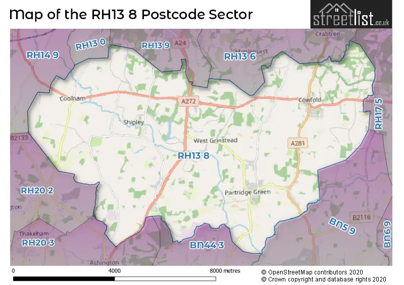
The largest settlement in the RH13 8 postal code is Partridge Green followed by Cowfold, and Shipley.
The RH13 8 Postcode shares a border with BN44 3 (STEYNING, Upper Beeding, Bramber), RH13 0 (Slinfold, Barns Green, Christs Hospital), RH13 6 (HORSHAM, Mannings Heath, Lower Beeding), RH13 9 (Southwater, HORSHAM), RH14 9 (BILLINGSHURST, Coneyhurst, Five Oaks), RH17 5 (Cuckfield, Bolney, Warninglid), RH20 2 (PULBOROUGH, West Chiltington, Nutbourne), RH20 3 (Storrington, Ashington, Thakeham) and BN5 9 (HENFIELD, Small Dole, Woodmancote).
The sector is within the post town of HORSHAM.
RH13 8 is a postcode sector within the RH13 postcode district which is within the RH Redhill postcode area.
The Royal Mail delivery office for the RH13 8 postal sector is the Horsham Delivery Office.
The area of the RH13 8 postcode sector is 28.58 square miles which is 74.03 square kilometres or 18,293.94 square acres.
Waterways within the RH13 8 postcode sector include the Adur.


Map of the RH13 8 Postcode Sector
Explore the RH13 8 postcode sector by using our free interactive map.
| R | H | 1 | 3 | - | 8 | X | X |
| R | H | 1 | 3 | Space | 8 | Letter | Letter |
Official List of Streets
Cowfold (25 Streets)
Shipley (16 Streets)
West Grinstead (13 Streets)
Partridge Green (39 Streets)
Dial Post (5 Streets)
Coolham (10 Streets)
Unofficial Streets or Alternative Spellings
Bolney
COWFOLD ROAD BAILEYS FARM BASING HILL BINES BRIDGE BOAR LANE BROOK HILL BROOMERS CORNER BROWNINGS HILL BUCK BARN BUNGALOWS BUCKHATCH LANE CAPONS HILL FARM CHURCH CAUSEWAY COACH HOUSE MEWS COOLHAM AIRFIELD DORSET HOUSE DOWNS LINK FARREN COURT FORD LANE GATELANDS GREEN LANE GREENTREE LANE GRINDERS LANE HANOVER GARDENS HILL HOUSE FARM HONEY BRIDGE HUNGERHILL JENDENS FARM KENTSTREET LANE KINGSBRIDGE LANE KIPPENS LANE LACKENHURST LANE LADIES WALK MERCERS MEAD MERCERS MEAD, OAKFIELD ROAD NEEDS HILL NETHERWOODS ROAD NO EVIDENCE OF THIS PATH PENBRIDGE LANE PERRYFIELD LANE PINLAND ROAD PONDTAIL FARM POTTERS GREEN RECTORY LANE SHERMANBURY GRANGE SOUTH LEAS SUMMER MEADOW THORNHILL COURT VILLAGE HALL LANE WAGSTAFF COTTAGES WALDEN CLOSE WEST CHILTINGTON LANE YEWTREE CLOSELower Beeding
BRIGHTON ROAD MILL LANEPartridge Green
HUFFWOOD TRADING ESTATEWest Grinstead
MAPLEHURST ROADHENFIELD
LONDON ROADSTEYNING
HORSHAM ROADSouthwater
BAR LANE OLD HOUSE LANE SHIPLEY ROADBrooks Green
COOLHAM ROADConeyhurst
OLDHOUSE LANEBroadford Bridge
WEST CHILTINGTON LANEAshington
LONDON ROAD SPEAR HILLWeather Forecast for RH13 8
Press Button to Show Forecast for West Grinstead
| Time Period | Icon | Description | Temperature | Rain Probability | Wind |
|---|---|---|---|---|---|
| 06:00 to 09:00 | Cloudy | 10.0°C (feels like 8.0°C) | 17.00% | SSW 7 mph | |
| 09:00 to 12:00 | Heavy rain | 10.0°C (feels like 7.0°C) | 76.00% | WNW 11 mph | |
| 12:00 to 15:00 | Light rain | 8.0°C (feels like 5.0°C) | 52.00% | W 13 mph | |
| 15:00 to 18:00 | Cloudy | 10.0°C (feels like 8.0°C) | 14.00% | WSW 11 mph | |
| 18:00 to 21:00 | Light rain shower (day) | 10.0°C (feels like 9.0°C) | 37.00% | SW 9 mph | |
| 21:00 to 00:00 | Clear night | 8.0°C (feels like 6.0°C) | 0.00% | SW 7 mph |
Press Button to Show Forecast for West Grinstead
| Time Period | Icon | Description | Temperature | Rain Probability | Wind |
|---|---|---|---|---|---|
| 00:00 to 03:00 | Clear night | 6.0°C (feels like 4.0°C) | 1.00% | SW 4 mph | |
| 03:00 to 06:00 | Clear night | 5.0°C (feels like 3.0°C) | 1.00% | SSW 4 mph | |
| 06:00 to 09:00 | Sunny day | 8.0°C (feels like 6.0°C) | 0.00% | S 7 mph | |
| 09:00 to 12:00 | Cloudy | 12.0°C (feels like 10.0°C) | 3.00% | SSW 13 mph | |
| 12:00 to 15:00 | Sunny day | 13.0°C (feels like 11.0°C) | 1.00% | S 13 mph | |
| 15:00 to 18:00 | Sunny day | 14.0°C (feels like 11.0°C) | 2.00% | SSW 11 mph | |
| 18:00 to 21:00 | Sunny day | 12.0°C (feels like 11.0°C) | 0.00% | SSE 7 mph | |
| 21:00 to 00:00 | Clear night | 9.0°C (feels like 7.0°C) | 0.00% | SE 7 mph |
Press Button to Show Forecast for West Grinstead
| Time Period | Icon | Description | Temperature | Rain Probability | Wind |
|---|---|---|---|---|---|
| 00:00 to 03:00 | Clear night | 9.0°C (feels like 7.0°C) | 0.00% | ESE 7 mph | |
| 03:00 to 06:00 | Clear night | 8.0°C (feels like 6.0°C) | 1.00% | SE 7 mph | |
| 06:00 to 09:00 | Partly cloudy (day) | 10.0°C (feels like 8.0°C) | 2.00% | SE 7 mph | |
| 09:00 to 12:00 | Cloudy | 14.0°C (feels like 12.0°C) | 12.00% | SSE 9 mph | |
| 12:00 to 15:00 | Light rain shower (day) | 15.0°C (feels like 13.0°C) | 32.00% | SSE 11 mph | |
| 15:00 to 18:00 | Light rain shower (day) | 15.0°C (feels like 13.0°C) | 31.00% | SSE 11 mph | |
| 18:00 to 21:00 | Partly cloudy (day) | 14.0°C (feels like 13.0°C) | 8.00% | SE 7 mph | |
| 21:00 to 00:00 | Cloudy | 11.0°C (feels like 10.0°C) | 11.00% | ESE 4 mph |
Press Button to Show Forecast for West Grinstead
| Time Period | Icon | Description | Temperature | Rain Probability | Wind |
|---|---|---|---|---|---|
| 00:00 to 03:00 | Cloudy | 11.0°C (feels like 10.0°C) | 13.00% | ESE 4 mph | |
| 03:00 to 06:00 | Cloudy | 9.0°C (feels like 8.0°C) | 12.00% | E 4 mph | |
| 06:00 to 09:00 | Mist | 10.0°C (feels like 9.0°C) | 20.00% | E 4 mph | |
| 09:00 to 12:00 | Cloudy | 14.0°C (feels like 14.0°C) | 11.00% | E 4 mph | |
| 12:00 to 15:00 | Cloudy | 17.0°C (feels like 16.0°C) | 12.00% | ESE 7 mph | |
| 15:00 to 18:00 | Cloudy | 17.0°C (feels like 16.0°C) | 15.00% | S 7 mph | |
| 18:00 to 21:00 | Light rain | 15.0°C (feels like 15.0°C) | 44.00% | SSE 4 mph | |
| 21:00 to 00:00 | Cloudy | 13.0°C (feels like 12.0°C) | 19.00% | SSW 7 mph |
Schools and Places of Education Within the RH13 8 Postcode Sector
Jolesfield CofE Primary School
Voluntary controlled school
Littleworth Lane, Horsham, West Sussex, RH13 8JJ
Head: Ms Vicky Price
Ofsted Rating: Good
Inspection: 2023-07-04 (299 days ago)
Website: Visit Jolesfield CofE Primary School Website
Phone: 01403710546
Number of Pupils: 148
Shipley CofE Primary School
Voluntary controlled school
School Lane, Horsham, West Sussex, RH13 8PL
Head: Mrs Jen Harvey
Ofsted Rating: Good
Inspection: 2018-12-06 (1970 days ago)
Website: Visit Shipley CofE Primary School Website
Phone: 01403741298
Number of Pupils: 78
St Peter's CofE (Aided) Primary School
Voluntary aided school
Potters Green, Horsham, West Sussex, RH13 8QZ
Head: Mr Giles Kolter
Ofsted Rating: Good
Inspection: 2021-12-01 (879 days ago)
Website: Visit St Peter's CofE (Aided) Primary School Website
Phone: 01403864365
Number of Pupils: 118
William Penn School
Voluntary controlled school
Brooks Green Road, Horsham, West Sussex, RH13 8GR
Head: Mr Stephen Kear
Ofsted Rating: Good
Inspection: 2019-03-12 (1874 days ago)
Website: Visit William Penn School Website
Phone: 01403741274
Number of Pupils: 99
House Prices in the RH13 8 Postcode Sector
| Type of Property | 2018 Average | 2018 Sales | 2017 Average | 2017 Sales | 2016 Average | 2016 Sales | 2015 Average | 2015 Sales |
|---|---|---|---|---|---|---|---|---|
| Detached | £674,223 | 31 | £649,843 | 22 | £555,926 | 27 | £595,747 | 33 |
| Semi-Detached | £404,943 | 21 | £394,354 | 24 | £449,105 | 19 | £337,152 | 20 |
| Terraced | £341,923 | 13 | £286,329 | 21 | £291,125 | 16 | £241,638 | 21 |
| Flats | £201,000 | 6 | £156,417 | 6 | £209,900 | 6 | £156,500 | 3 |
Important Postcodes RH13 8 in the Postcode Sector
RH13 8GR is the postcode for William Penn Primary School, Brooks Green Road
RH13 8JJ is the postcode for Jolesfield C of E Primary School, Littleworth Lane
RH13 8PL is the postcode for School House, School Lane
RH13 8QZ is the postcode for St. Peters C of E Primary School, Potters Green, Station Road
| The RH13 8 Sector is within these Local Authorities |
|
|---|---|
| The RH13 8 Sector is within these Counties |
|
| The RH13 8 Sector is within these Water Company Areas |
|