The RH20 2 postcode sector is within the county of West Sussex.
Did you know? According to the 2021 Census, the RH20 2 postcode sector is home to a bustling 7,012 residents!
Given that each sector allows for 400 unique postcode combinations. Letters C, I, K, M, O and V are not allowed in the last two letters of a postcode. With 242 postcodes already in use, this leaves 158 units available.
The largest settlement in the RH20 2 postal code is PULBOROUGH followed by West Chiltington, and Nutbourne.
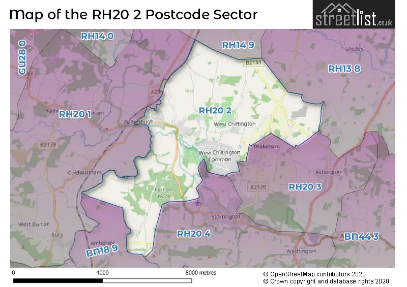
The RH20 2 Postcode shares a border with RH13 8 (Partridge Green, Cowfold, Shipley), RH14 9 (BILLINGSHURST, Coneyhurst, Five Oaks), RH20 1 (PULBOROUGH, Fittleworth, Codmore Hill), RH20 3 (Storrington, Ashington, Thakeham), RH20 4 (Storrington, Washington, Cootham) and BN18 9 (ARUNDEL, Amberley, Poling).
The sector is within the post town of PULBOROUGH.
RH20 2 is a postcode sector within the RH20 postcode district which is within the RH Redhill postcode area.
The Royal Mail delivery office for the RH20 2 postal sector is the Pulborough Delivery Office.
The area of the RH20 2 postcode sector is 15.31 square miles which is 39.65 square kilometres or 9,797.67 square acres.
Waterways within the RH20 2 postcode sector include the Arun.

Map of the RH20 2 Postcode Sector
Explore the RH20 2 postcode sector by using our free interactive map.
| R | H | 2 | 0 | - | 2 | X | X |
| R | H | 2 | 0 | Space | 2 | Letter | Letter |
Official List of Streets
PULBOROUGH (56 Streets)
West Chiltington (75 Streets)
Goose Green (4 Streets)
Codmore Hill (2 Streets)
North Heath (3 Streets)
Greatham (2 Streets)
Nutbourne (4 Streets)
Rackham (2 Streets)
Unofficial Streets or Alternative Spellings
Brooks Green
COOLHAM ROADConeyhurst
OLDHOUSE LANEAshington
BILLINGSHURST ROAD ALLFREYS WHARF APSLEY FARM ARUN COURT BEEDINGS CASTLE BROOK CHASE CARPE DIEM CHESTNUT RIDGE CHURCH LANE COPSE VIEW DUKES HILL GATEWICK FARM LANE GLEBE LANDS GOOSEGREEN LANE GREATHAM BRIDGE HARBOROUGH MEADOW HATCHES ESTATE HILLCREST PARK HURSTON PLACE FARM KINGSWOOD LAUREL MOUNT LINK DRIVE LOWER JORDANS LANE LOWERHILL FARM MALLARDS COURT MONKEY HILL MOONS FARM NYETIMBER VINEYARD OAKVALE OLD PIG SHED QUELL FARM PANNERS DRIVE PARK LANE (PUBLIC WAY) QUELL FARM SILVER WOOD COPSE SKEYNE MEWS SOUTH SIDE SPINNEY MEWS STALLHOUSE LANE STEELE CLOSE THE HAWTHORNS THE TWITTEN WANSEYS FARM WEST SUSSEX 5341 WESTLANDS FARM WHEELWRIGHTS WILLOW CLOSE WYCHACREWest Chiltington
HILLSTREAM CLOSEStorrington
HURSTON LANE WEST CHILTINGTON ROADPULBOROUGH
CHESTNUT WALK CHURCH HILL LONDON ROADCootham
PULBOROUGH ROADParham
AMBERLEY ROADAdversane
STANE STREETAmberley
RACKHAM ROAD TURNPIKE ROADColdwaltham
BROOK LANE LONDON ROADWeather Forecast for RH20 2
Press Button to Show Forecast for Pulborough
| Time Period | Icon | Description | Temperature | Rain Probability | Wind |
|---|---|---|---|---|---|
| 06:00 to 09:00 | Cloudy | 6.0°C (feels like 3.0°C) | 8.00% | NE 9 mph | |
| 09:00 to 12:00 | Cloudy | 8.0°C (feels like 5.0°C) | 9.00% | ENE 9 mph | |
| 12:00 to 15:00 | Overcast | 10.0°C (feels like 8.0°C) | 16.00% | ENE 9 mph | |
| 15:00 to 18:00 | Overcast | 11.0°C (feels like 10.0°C) | 16.00% | ENE 7 mph | |
| 18:00 to 21:00 | Cloudy | 10.0°C (feels like 9.0°C) | 12.00% | ENE 7 mph | |
| 21:00 to 00:00 | Cloudy | 7.0°C (feels like 5.0°C) | 11.00% | E 7 mph |
Press Button to Show Forecast for Pulborough
| Time Period | Icon | Description | Temperature | Rain Probability | Wind |
|---|---|---|---|---|---|
| 00:00 to 03:00 | Overcast | 5.0°C (feels like 3.0°C) | 21.00% | ENE 7 mph | |
| 03:00 to 06:00 | Cloudy | 5.0°C (feels like 3.0°C) | 21.00% | ENE 7 mph | |
| 06:00 to 09:00 | Cloudy | 7.0°C (feels like 4.0°C) | 18.00% | ENE 9 mph | |
| 09:00 to 12:00 | Overcast | 10.0°C (feels like 8.0°C) | 18.00% | E 11 mph | |
| 12:00 to 15:00 | Light rain | 13.0°C (feels like 11.0°C) | 48.00% | E 11 mph | |
| 15:00 to 18:00 | Light rain shower (day) | 12.0°C (feels like 10.0°C) | 42.00% | ENE 11 mph | |
| 18:00 to 21:00 | Light rain | 11.0°C (feels like 8.0°C) | 50.00% | ENE 11 mph | |
| 21:00 to 00:00 | Heavy rain | 10.0°C (feels like 7.0°C) | 71.00% | NE 11 mph |
Press Button to Show Forecast for Pulborough
| Time Period | Icon | Description | Temperature | Rain Probability | Wind |
|---|---|---|---|---|---|
| 00:00 to 03:00 | Light rain | 10.0°C (feels like 7.0°C) | 51.00% | ENE 11 mph | |
| 03:00 to 06:00 | Heavy rain shower (night) | 10.0°C (feels like 8.0°C) | 59.00% | SE 9 mph | |
| 06:00 to 09:00 | Light rain | 10.0°C (feels like 8.0°C) | 50.00% | SE 9 mph | |
| 09:00 to 12:00 | Light rain shower (day) | 11.0°C (feels like 9.0°C) | 46.00% | SSE 11 mph | |
| 12:00 to 15:00 | Heavy rain shower (day) | 13.0°C (feels like 11.0°C) | 54.00% | SW 13 mph | |
| 15:00 to 18:00 | Light rain shower (day) | 13.0°C (feels like 11.0°C) | 39.00% | SW 11 mph | |
| 18:00 to 21:00 | Cloudy | 12.0°C (feels like 9.0°C) | 13.00% | SW 11 mph | |
| 21:00 to 00:00 | Cloudy | 10.0°C (feels like 8.0°C) | 8.00% | WSW 7 mph |
Schools and Places of Education Within the RH20 2 Postcode Sector
St Mary's Church of England Primary School
Voluntary aided school
Link Lane, Pulborough, West Sussex, RH20 2AN
Head: Mrs Samantha Copus
Ofsted Rating: Good
Inspection: 2022-09-22 (582 days ago)
Website: Visit St Mary's Church of England Primary School Website
Phone: 01798872007
Number of Pupils: 310
West Chiltington Community Primary School
Community school
East Street, Pulborough, West Sussex, RH20 2JY
Head: Miss Helen Drummond
Ofsted Rating: Good
Inspection: 2019-10-02 (1668 days ago)
Website: Visit West Chiltington Community Primary School Website
Phone: 01798813319
Number of Pupils: 201
House Prices in the RH20 2 Postcode Sector
| Type of Property | 2018 Average | 2018 Sales | 2017 Average | 2017 Sales | 2016 Average | 2016 Sales | 2015 Average | 2015 Sales |
|---|---|---|---|---|---|---|---|---|
| Detached | £735,011 | 70 | £697,373 | 81 | £718,173 | 81 | £652,798 | 90 |
| Semi-Detached | £359,663 | 15 | £343,800 | 15 | £354,063 | 16 | £360,208 | 24 |
| Terraced | £295,288 | 13 | £310,838 | 8 | £294,672 | 23 | £251,208 | 18 |
| Flats | £201,686 | 14 | £272,563 | 8 | £211,846 | 14 | £244,355 | 21 |
Important Postcodes RH20 2 in the Postcode Sector
RH20 2AN is the postcode for St. Marys C of E Primary School, Link Lane
RH20 2JY is the postcode for MAIN BUILDING, West Chiltington Community First School, East Street, and West Chiltington Community First School, East Street
| The RH20 2 Sector is within these Local Authorities |
|
|---|---|
| The RH20 2 Sector is within these Counties |
|
| The RH20 2 Sector is within these Water Company Areas |
|