The BS48 1 postcode sector is within the county of Somerset.
Did you know? According to the 2021 Census, the BS48 1 postcode sector is home to a bustling 5,238 residents!
Given that each sector allows for 400 unique postcode combinations. Letters C, I, K, M, O and V are not allowed in the last two letters of a postcode. With 199 postcodes already in use, this leaves 201 units available.
The largest settlement in the BS48 1 postal code is Nailsea followed by Wraxall, and Flax Bourton.
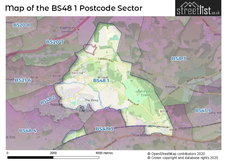
The BS48 1 Postcode shares a border with BS8 3 (BRISTOL, Clifton, Failand), BS20 7 (Portishead, Portbury, Clapton In Gordano), BS21 6 (CLEVEDON, Tickenham, Kenn), BS48 2 (Nailsea), BS48 3 (Backwell, Barrow Gurney, Flax Bourton) and BS48 4 (Nailsea, Brockley, Backwell).
The sector is within the post town of BRISTOL.
BS48 1 is a postcode sector within the BS48 postcode district which is within the BS Bristol postcode area.
The Royal Mail delivery office for the BS48 1 postal sector is the Nailsea Delivery Office.
The area of the BS48 1 postcode sector is 4.77 square miles which is 12.36 square kilometres or 3,054.48 square acres.
Waterways within the BS48 1 postcode sector include the Tickenham Boundary Rhyne, Yeo River.

Map of the BS48 1 Postcode Sector
Explore the BS48 1 postcode sector by using our free interactive map.
| B | S | 4 | 8 | - | 1 | X | X |
| B | S | 4 | 8 | Space | 1 | Letter | Letter |
Official List of Streets
Nailsea (65 Streets)
Wraxall (25 Streets)
Flax Bourton (10 Streets)
Backwell (2 Streets)
Unofficial Streets or Alternative Spellings
Portbury
PORTBURY LANE BACKWELL VIEW BIRCH DENE BLACKTHORN WAY CHRISTCHURCH CLOSE GORDANO ROUND SERVICE YARD A SERVICE YARD B SERVICE YARD C STANTON LANE STONEY STEEP SUE OTTEY WAY THE COURTYARD THE GINNELNailsea
BUCKLANDS BATCH CAVERSHAM DRIVE MIZZYMEAD ROAD OAKSEY GROVE POUND LANE STOCK WAY SOUTH SUNNYMEDE ROAD WESTWAYFailand
CLEVEDON ROADTickenham
TICKENHAM HILLFlax Bourton
MAIN ROAD WESTON ROADClapton In Gordano
CADBURY CAMP LANEWeather Forecast for BS48 1
Press Button to Show Forecast for Nailsea
| Time Period | Icon | Description | Temperature | Rain Probability | Wind |
|---|---|---|---|---|---|
| 00:00 to 03:00 | Cloudy | 8.0°C (feels like 6.0°C) | 6.00% | NE 4 mph | |
| 03:00 to 06:00 | Overcast | 7.0°C (feels like 5.0°C) | 8.00% | ENE 7 mph | |
| 06:00 to 09:00 | Cloudy | 6.0°C (feels like 4.0°C) | 8.00% | ENE 7 mph | |
| 09:00 to 12:00 | Cloudy | 8.0°C (feels like 6.0°C) | 10.00% | E 9 mph | |
| 12:00 to 15:00 | Overcast | 10.0°C (feels like 8.0°C) | 15.00% | E 9 mph | |
| 15:00 to 18:00 | Overcast | 11.0°C (feels like 9.0°C) | 19.00% | E 9 mph | |
| 18:00 to 21:00 | Cloudy | 10.0°C (feels like 8.0°C) | 17.00% | E 7 mph | |
| 21:00 to 00:00 | Cloudy | 9.0°C (feels like 7.0°C) | 16.00% | ENE 7 mph |
Press Button to Show Forecast for Nailsea
| Time Period | Icon | Description | Temperature | Rain Probability | Wind |
|---|---|---|---|---|---|
| 00:00 to 03:00 | Cloudy | 7.0°C (feels like 5.0°C) | 14.00% | ENE 7 mph | |
| 03:00 to 06:00 | Cloudy | 7.0°C (feels like 4.0°C) | 14.00% | ENE 9 mph | |
| 06:00 to 09:00 | Overcast | 6.0°C (feels like 3.0°C) | 25.00% | NE 9 mph | |
| 09:00 to 12:00 | Light rain | 8.0°C (feels like 5.0°C) | 52.00% | ENE 11 mph | |
| 12:00 to 15:00 | Overcast | 10.0°C (feels like 7.0°C) | 21.00% | ENE 11 mph | |
| 15:00 to 18:00 | Cloudy | 11.0°C (feels like 9.0°C) | 16.00% | ENE 11 mph | |
| 18:00 to 21:00 | Overcast | 11.0°C (feels like 8.0°C) | 22.00% | NE 11 mph | |
| 21:00 to 00:00 | Light rain | 9.0°C (feels like 7.0°C) | 50.00% | NE 11 mph |
Press Button to Show Forecast for Nailsea
| Time Period | Icon | Description | Temperature | Rain Probability | Wind |
|---|---|---|---|---|---|
| 00:00 to 03:00 | Light rain | 8.0°C (feels like 6.0°C) | 51.00% | NE 11 mph | |
| 03:00 to 06:00 | Light rain | 8.0°C (feels like 5.0°C) | 52.00% | NE 11 mph | |
| 06:00 to 09:00 | Light rain | 8.0°C (feels like 5.0°C) | 52.00% | NNE 9 mph | |
| 09:00 to 12:00 | Light rain | 9.0°C (feels like 7.0°C) | 50.00% | NE 11 mph | |
| 12:00 to 15:00 | Light rain shower (day) | 11.0°C (feels like 9.0°C) | 46.00% | NNW 11 mph | |
| 15:00 to 18:00 | Light rain | 12.0°C (feels like 9.0°C) | 53.00% | NW 11 mph | |
| 18:00 to 21:00 | Light rain shower (day) | 12.0°C (feels like 10.0°C) | 35.00% | NNW 9 mph | |
| 21:00 to 00:00 | Clear night | 10.0°C (feels like 8.0°C) | 7.00% | NW 9 mph |
Schools and Places of Education Within the BS48 1 Postcode Sector
Wraxall Church of England Primary School
Academy converter
Bristol Road, Bristol, Somerset, BS48 1LB
Head: Miss Amy Townsend
Ofsted Rating: Good
Inspection: 2022-11-02 (541 days ago)
Website: Visit Wraxall Church of England Primary School Website
Phone: 01275854216
Number of Pupils: 80
House Prices in the BS48 1 Postcode Sector
| Type of Property | 2018 Average | 2018 Sales | 2017 Average | 2017 Sales | 2016 Average | 2016 Sales | 2015 Average | 2015 Sales |
|---|---|---|---|---|---|---|---|---|
| Detached | £520,415 | 39 | £518,776 | 34 | £519,732 | 43 | £433,804 | 36 |
| Semi-Detached | £275,610 | 29 | £308,203 | 29 | £307,160 | 20 | £263,201 | 25 |
| Terraced | £303,871 | 12 | £280,883 | 9 | £254,813 | 8 | £233,600 | 5 |
| Flats | £181,750 | 14 | £160,671 | 17 | £234,656 | 52 | £119,969 | 13 |
Important Postcodes BS48 1 in the Postcode Sector
BS48 1BB is the postcode for Golden Valley Primary School, Nailsea Park, and Golden Valley Primary, Nailsea Park
BS48 1BZ is the postcode for Brockway Medical Centre, 8 Brockway, Scotch Horn Community & Sports Centre, Brockway, Scotch Horn Leisure Centre, Brockway, Scotch Horn Community & Sports Centre, Brockway, Nailsea, and SCOTCH HORN LEISURE CENTRE, BROCKWAY, NAILSEA
BS48 1RQ is the postcode for North Somerset Council, Nailsea Library, Somerset Square, and Weston College, Somerset Square
BS48 1UA is the postcode for Flax Bourton Primary School, Station Road
BS48 1UL is the postcode for The Courthouse, Old Weston Road, and Flax Bourton Public Mortuary, Old Weston Road
BS48 1UN is the postcode for Flax Bourton Highways Depot, Old Weston Road
| The BS48 1 Sector is within these Local Authorities |
|
|---|---|
| The BS48 1 Sector is within these Counties |
|
| The BS48 1 Sector is within these Water Company Areas |
|
Tourist Attractions within the BS48 1 Postcode Area
We found 2 visitor attractions within the BS48 postcode area
| Noah's Ark Zoo Farm |
|---|
| Wildlife |
| Safari Park / Zoo / Aquarium / Aviary |
| View Noah's Ark Zoo Farm on Google Maps |
| Tyntesfield |
| Historic Properties |
| Historic House / House and Garden / Palace |
| View Tyntesfield on Google Maps |