The BS5 8 postcode sector stands on the Bristol and Gloucestershire border.
Did you know? According to the 2021 Census, the BS5 8 postcode sector is home to a bustling 10,368 residents!
Given that each sector allows for 400 unique postcode combinations. Letters C, I, K, M, O and V are not allowed in the last two letters of a postcode. With 267 postcodes already in use, this leaves 133 units available.
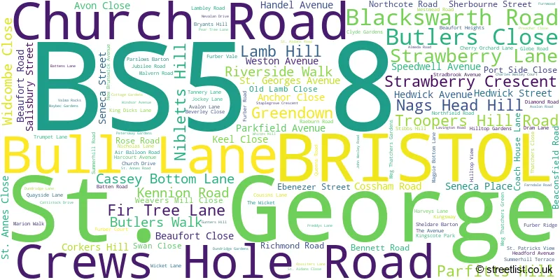
The largest settlements in the BS5 8 postal code are BRISTOL and St. George.
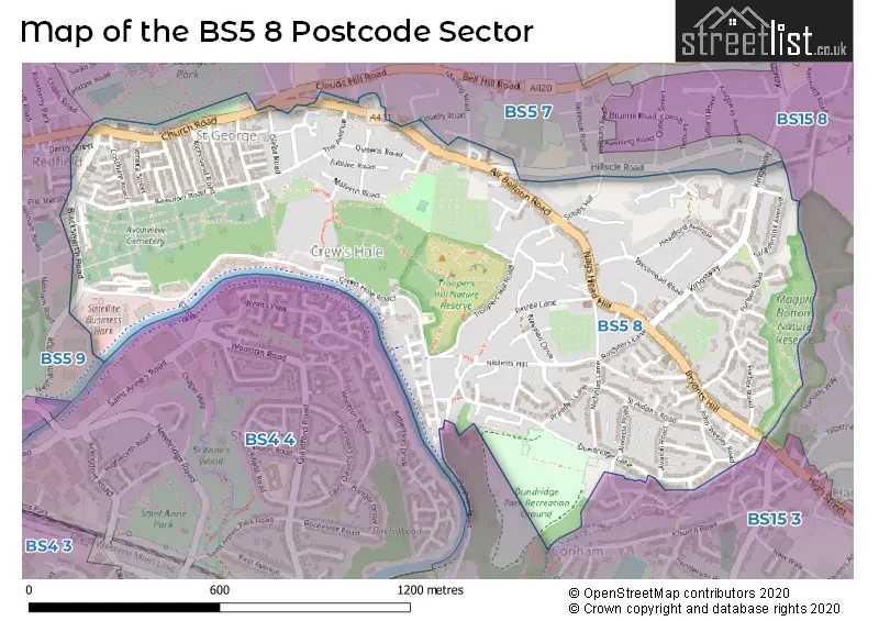
The BS5 8 Postcode shares a border with BS4 4 (BRISTOL, St. Annes Park, Brislington), BS5 9 (BRISTOL, Redfield, Barton Hill), BS15 3 (Hanham, BRISTOL), BS5 7 (BRISTOL, St. George, Speedwell) and BS15 8 (BRISTOL, Kingswood, Hanham).
The sector is within the post town of BRISTOL.
BS5 8 is a postcode sector within the BS5 postcode district which is within the BS Bristol postcode area.
The Royal Mail delivery office for the BS5 8 postal sector is the Bristol East Delivery Office.
The area of the BS5 8 postcode sector is 0.72 square miles which is 1.86 square kilometres or 459.67 square acres.
Waterways within the BS5 8 postcode sector include the River Avon.

Map of the BS5 8 Postcode Sector
Explore the BS5 8 postcode sector by using our free interactive map.
| B | S | 5 | - | 8 | X | X |
| B | S | 5 | Space | 8 | Letter | Letter |
Official List of Streets
BRISTOL (102 Streets)
St. George (26 Streets)
Unofficial Streets or Alternative Spellings
BRISTOL
BETHEL ROAD CHALKS ROAD CHERRY ORCHARD LANE CLOUDS HILL ROAD CLOVELLY CLOSE CLOVELLY ROAD CONHAM ROAD DERBY STREET GRINDELL ROAD HILLSIDE ROAD LEWIN STREET MARLING ROAD PARK VIEW TERRACE PILEMARSH UPPER CONHAM VALEKingswood
KINGSWAY MAGPIE BOTTOM LANEHanham
POLLY BARNES HILL POPLAR ROAD BATTENS ROAD FARNDALE FIRECLAY ROAD FIRTREE LANE GILLINGHAM HILL HARDINGS TERRACE HILLSIDE COURT MALVERN COURT MILL COURT OLD FARM LANE PEARTREE LANE PORTSIDE CLOSE RAGLAN LANE RIVERSIDE PLACE SAINT ANNES ROAD SAINT GEORGES AVENUE THE GULLYLawrence Hill
CHURCH ROADWeather Forecast for BS5 8
Press Button to Show Forecast for Crew's Hole
| Time Period | Icon | Description | Temperature | Rain Probability | Wind |
|---|---|---|---|---|---|
| 09:00 to 12:00 | Cloudy | 7.0°C (feels like 4.0°C) | 10.00% | ENE 9 mph | |
| 12:00 to 15:00 | Overcast | 9.0°C (feels like 7.0°C) | 9.00% | E 9 mph | |
| 15:00 to 18:00 | Overcast | 10.0°C (feels like 8.0°C) | 15.00% | E 9 mph | |
| 18:00 to 21:00 | Cloudy | 10.0°C (feels like 8.0°C) | 12.00% | E 7 mph | |
| 21:00 to 00:00 | Overcast | 8.0°C (feels like 7.0°C) | 53.00% | E 7 mph |
Press Button to Show Forecast for Crew's Hole
| Time Period | Icon | Description | Temperature | Rain Probability | Wind |
|---|---|---|---|---|---|
| 00:00 to 03:00 | Light rain | 7.0°C (feels like 5.0°C) | 53.00% | ENE 7 mph | |
| 03:00 to 06:00 | Light rain | 6.0°C (feels like 3.0°C) | 55.00% | ENE 9 mph | |
| 06:00 to 09:00 | Cloudy | 6.0°C (feels like 2.0°C) | 17.00% | NE 11 mph | |
| 09:00 to 12:00 | Cloudy | 7.0°C (feels like 3.0°C) | 12.00% | NE 11 mph | |
| 12:00 to 15:00 | Cloudy | 9.0°C (feels like 6.0°C) | 10.00% | ENE 11 mph | |
| 15:00 to 18:00 | Cloudy | 10.0°C (feels like 8.0°C) | 8.00% | NE 11 mph | |
| 18:00 to 21:00 | Cloudy | 9.0°C (feels like 6.0°C) | 9.00% | NNE 11 mph | |
| 21:00 to 00:00 | Cloudy | 8.0°C (feels like 5.0°C) | 12.00% | NNE 11 mph |
Press Button to Show Forecast for Crew's Hole
| Time Period | Icon | Description | Temperature | Rain Probability | Wind |
|---|---|---|---|---|---|
| 00:00 to 03:00 | Light rain | 7.0°C (feels like 3.0°C) | 48.00% | NNE 11 mph | |
| 03:00 to 06:00 | Heavy rain | 6.0°C (feels like 2.0°C) | 78.00% | N 13 mph | |
| 06:00 to 09:00 | Heavy rain | 6.0°C (feels like 2.0°C) | 75.00% | N 11 mph | |
| 09:00 to 12:00 | Light rain | 7.0°C (feels like 4.0°C) | 51.00% | NNW 9 mph | |
| 12:00 to 15:00 | Cloudy | 10.0°C (feels like 7.0°C) | 16.00% | WNW 9 mph | |
| 15:00 to 18:00 | Cloudy | 11.0°C (feels like 9.0°C) | 12.00% | W 9 mph | |
| 18:00 to 21:00 | Sunny day | 10.0°C (feels like 8.0°C) | 4.00% | WSW 9 mph | |
| 21:00 to 00:00 | Clear night | 8.0°C (feels like 6.0°C) | 1.00% | WSW 7 mph |
Press Button to Show Forecast for Crew's Hole
| Time Period | Icon | Description | Temperature | Rain Probability | Wind |
|---|---|---|---|---|---|
| 00:00 to 03:00 | Clear night | 6.0°C (feels like 4.0°C) | 1.00% | SSW 7 mph | |
| 03:00 to 06:00 | Clear night | 5.0°C (feels like 3.0°C) | 2.00% | S 7 mph | |
| 06:00 to 09:00 | Sunny day | 6.0°C (feels like 4.0°C) | 2.00% | SSE 7 mph | |
| 09:00 to 12:00 | Cloudy | 11.0°C (feels like 9.0°C) | 6.00% | S 13 mph | |
| 12:00 to 15:00 | Cloudy | 13.0°C (feels like 10.0°C) | 7.00% | S 13 mph | |
| 15:00 to 18:00 | Cloudy | 13.0°C (feels like 10.0°C) | 7.00% | S 16 mph | |
| 18:00 to 21:00 | Sunny day | 12.0°C (feels like 10.0°C) | 4.00% | S 11 mph | |
| 21:00 to 00:00 | Clear night | 10.0°C (feels like 7.0°C) | 4.00% | SSE 11 mph |
Press Button to Show Forecast for Crew's Hole
| Time Period | Icon | Description | Temperature | Rain Probability | Wind |
|---|---|---|---|---|---|
| 00:00 to 03:00 | Cloudy | 9.0°C (feels like 6.0°C) | 7.00% | SE 9 mph | |
| 03:00 to 06:00 | Clear night | 8.0°C (feels like 6.0°C) | 4.00% | SE 9 mph | |
| 06:00 to 09:00 | Sunny day | 8.0°C (feels like 6.0°C) | 5.00% | SE 9 mph | |
| 09:00 to 12:00 | Partly cloudy (day) | 12.0°C (feels like 10.0°C) | 9.00% | SE 13 mph | |
| 12:00 to 15:00 | Partly cloudy (day) | 15.0°C (feels like 12.0°C) | 9.00% | SE 13 mph | |
| 15:00 to 18:00 | Cloudy | 15.0°C (feels like 12.0°C) | 16.00% | SE 11 mph | |
| 18:00 to 21:00 | Cloudy | 14.0°C (feels like 12.0°C) | 12.00% | SE 9 mph | |
| 21:00 to 00:00 | Clear night | 11.0°C (feels like 10.0°C) | 6.00% | SE 7 mph |
Schools and Places of Education Within the BS5 8 Postcode Sector
St Patrick's Catholic Primary School
Academy converter
Blackswarth Road, Bristol, , BS5 8AS
Head: Mrs Michele Marshall
Ofsted Rating: Outstanding
Inspection: 2013-06-12 (3971 days ago)
Website: Visit St Patrick's Catholic Primary School Website
Phone: 01173772387
Number of Pupils: 206
House Prices in the BS5 8 Postcode Sector
| Type of Property | 2018 Average | 2018 Sales | 2017 Average | 2017 Sales | 2016 Average | 2016 Sales | 2015 Average | 2015 Sales |
|---|---|---|---|---|---|---|---|---|
| Detached | £280,222 | 9 | £319,300 | 7 | £324,718 | 16 | £229,556 | 8 |
| Semi-Detached | £276,657 | 28 | £262,808 | 30 | £234,642 | 31 | £220,432 | 17 |
| Terraced | £264,910 | 115 | £243,952 | 110 | £229,047 | 131 | £199,188 | 136 |
| Flats | £174,400 | 63 | £161,340 | 90 | £155,759 | 71 | £130,210 | 70 |
Important Postcodes BS5 8 in the Postcode Sector
BS5 8AL is the postcode for St. George Public Library, Church Road
BS5 8AS is the postcode for St. Patricks RC School, Blackswarth Road, and DINING ROOM BUILDING, St. Patricks RC School, Blackswarth Road
BS5 8HX is the postcode for EAST BRISTOL INTERMEDIATE CARE, 17, Summerhill Terrace
| The BS5 8 Sector is within these Local Authorities |
|
|---|---|
| The BS5 8 Sector is within these Counties |
|
| The BS5 8 Sector is within these Water Company Areas |
|