The CF40 1 postcode sector is within the county of Mid Glamorgan.
Did you know? According to the 2021 Census, the CF40 1 postcode sector is home to a bustling 8,977 residents!
Given that each sector allows for 400 unique postcode combinations. Letters C, I, K, M, O and V are not allowed in the last two letters of a postcode. With 219 postcodes already in use, this leaves 181 units available.
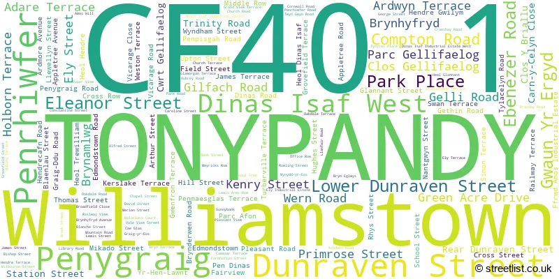
The largest settlement in the CF40 1 postal code is TONYPANDY followed by PEN-Y-GRAIG, and WILLIAMSTOWN.
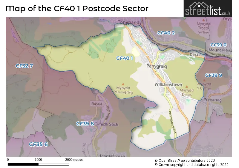
The CF40 1 Postcode shares a border with CF32 7 (OGMORE VALE, Nantymoel, NANT-Y-MOEL), CF39 9 (PORTH, CYMER, TREBANOG), CF40 2 (TONYPANDY, TREALAW, CLYDACH), CF39 0 (PORTH, YNYS-HIR, Wattstown) and CF39 8 (TONYREFAIL, Gilfach Goch, HENDREFORGAN).
The sector is within the post town of TONYPANDY.
CF40 1 is a postcode sector within the CF40 postcode district which is within the CF Cardiff postcode area.
The Royal Mail delivery office for the CF40 1 postal sector is the Mid Rhondda Ganol Delivery Office.
The area of the CF40 1 postcode sector is 4.20 square miles which is 10.89 square kilometres or 2,690.02 square acres.

Map of the CF40 1 Postcode Sector
Explore the CF40 1 postcode sector by using our free interactive map.
| C | F | 4 | 0 | - | 1 | X | X |
| C | F | 4 | 0 | Space | 1 | Letter | Letter |
Official List of Streets
TONYPANDY (112 Streets)
Williamstown (11 Streets)
Penygraig (10 Streets)
Unofficial Streets or Alternative Spellings
PORTH
CYMMER ROAD PEN DARRENTONYPANDY
BRIDGE STREET CLYDACH ROAD MYNYDD-YR-EOS STATION ROAD YR-HEN-LAWNT BELLE VIEW BLAENAU STREET BLANCH STREET CARN Y CELYN CLOSE CWRT GELLI DERWYDD ROAD GRAIG DDU PLACE GRAIG-YR-EOS TERRACE HENDREGWILYM MIDDLE STREET PENRHIW-FER ROAD SIMON STREET VALE VIEW WESTON ROADWeather Forecast for CF40 1
Press Button to Show Forecast for Tonypandy
| Time Period | Icon | Description | Temperature | Rain Probability | Wind |
|---|---|---|---|---|---|
| 09:00 to 12:00 | Cloudy | 7.0°C (feels like 5.0°C) | 10.00% | E 9 mph | |
| 12:00 to 15:00 | Overcast | 9.0°C (feels like 7.0°C) | 13.00% | E 9 mph | |
| 15:00 to 18:00 | Overcast | 10.0°C (feels like 8.0°C) | 14.00% | E 9 mph | |
| 18:00 to 21:00 | Cloudy | 9.0°C (feels like 7.0°C) | 16.00% | E 7 mph | |
| 21:00 to 00:00 | Cloudy | 7.0°C (feels like 5.0°C) | 17.00% | ENE 7 mph |
Press Button to Show Forecast for Tonypandy
| Time Period | Icon | Description | Temperature | Rain Probability | Wind |
|---|---|---|---|---|---|
| 00:00 to 03:00 | Cloudy | 6.0°C (feels like 4.0°C) | 17.00% | ENE 7 mph | |
| 03:00 to 06:00 | Cloudy | 5.0°C (feels like 3.0°C) | 13.00% | ENE 7 mph | |
| 06:00 to 09:00 | Cloudy | 5.0°C (feels like 3.0°C) | 10.00% | NE 9 mph | |
| 09:00 to 12:00 | Overcast | 7.0°C (feels like 4.0°C) | 19.00% | ENE 11 mph | |
| 12:00 to 15:00 | Overcast | 9.0°C (feels like 6.0°C) | 20.00% | ENE 11 mph | |
| 15:00 to 18:00 | Cloudy | 10.0°C (feels like 7.0°C) | 15.00% | ENE 11 mph | |
| 18:00 to 21:00 | Cloudy | 9.0°C (feels like 7.0°C) | 17.00% | NE 11 mph | |
| 21:00 to 00:00 | Light rain | 8.0°C (feels like 5.0°C) | 50.00% | NE 9 mph |
Press Button to Show Forecast for Tonypandy
| Time Period | Icon | Description | Temperature | Rain Probability | Wind |
|---|---|---|---|---|---|
| 00:00 to 03:00 | Light rain | 7.0°C (feels like 4.0°C) | 48.00% | NE 9 mph | |
| 03:00 to 06:00 | Cloudy | 7.0°C (feels like 4.0°C) | 22.00% | NNE 9 mph | |
| 06:00 to 09:00 | Cloudy | 7.0°C (feels like 4.0°C) | 21.00% | NNE 9 mph | |
| 09:00 to 12:00 | Cloudy | 9.0°C (feels like 6.0°C) | 16.00% | NNE 9 mph | |
| 12:00 to 15:00 | Light rain | 11.0°C (feels like 8.0°C) | 49.00% | NNW 9 mph | |
| 15:00 to 18:00 | Light rain shower (day) | 11.0°C (feels like 9.0°C) | 39.00% | NNW 9 mph | |
| 18:00 to 21:00 | Cloudy | 11.0°C (feels like 9.0°C) | 12.00% | NNW 9 mph | |
| 21:00 to 00:00 | Clear night | 8.0°C (feels like 6.0°C) | 3.00% | NW 7 mph |
House Prices in the CF40 1 Postcode Sector
| Type of Property | 2018 Average | 2018 Sales | 2017 Average | 2017 Sales | 2016 Average | 2016 Sales | 2015 Average | 2015 Sales |
|---|---|---|---|---|---|---|---|---|
| Detached | £225,617 | 16 | £179,688 | 8 | £144,188 | 8 | £157,825 | 7 |
| Semi-Detached | £117,789 | 22 | £104,208 | 12 | £98,930 | 22 | £108,496 | 12 |
| Terraced | £79,904 | 112 | £75,532 | 101 | £72,627 | 85 | £69,941 | 72 |
| Flats | £49,888 | 1 | £0 | 0 | £0 | 0 | £36,000 | 2 |
Important Postcodes CF40 1 in the Postcode Sector
CF40 1AG is the postcode for WILLIAMSTOWN PRIMARY SCHOOL, DINAS ISAF INDUSTRIAL ESTATE WEST, PENRHIW-FER, and Williamstown Primary School, Dinas Isaf West
CF40 1BE is the postcode for Rhondda Housing Association, 9 Compton Road
CF40 1BJ is the postcode for St. Gabriel & St. Raphael RC Primary School, Primrose Street
CF40 1BQ is the postcode for BUILDING TWO, Tonypandy Primary School, Primrose Street, and BUILDING ONE, Tonypandy Primary School, Primrose Street
CF40 1HQ is the postcode for Tonypandy Community College, Llewellyn Street
CF40 1LJ is the postcode for Pen-y-Graig Infant School, Hendrecafn Road
CF40 1LW is the postcode for Pen-y-Graig Junior School, Hendrecafn Road
CF40 1NY is the postcode for Ty Elai, Rhondda Cynon Taf County Borough Council, RHONDDA CYNON TAF CBC TY ELAI, DINAS ISAF INDUSTRIAL ESTATE, EDMONDSTOWN, and Ty Elai, Dinas Isaf Industrial Estate, Edmondstown
CF40 1PQ is the postcode for Tai Education Centre, Bishop Street, Penygraig, and Tai Education Centre, Bishop Street
CF40 1RE is the postcode for Social Centre for the Aged, Nazareth House, Brook Street
| The CF40 1 Sector is within these Local Authorities |
|
|---|---|
| The CF40 1 Sector is within these Counties |
|
| The CF40 1 Sector is within these Water Company Areas |
|