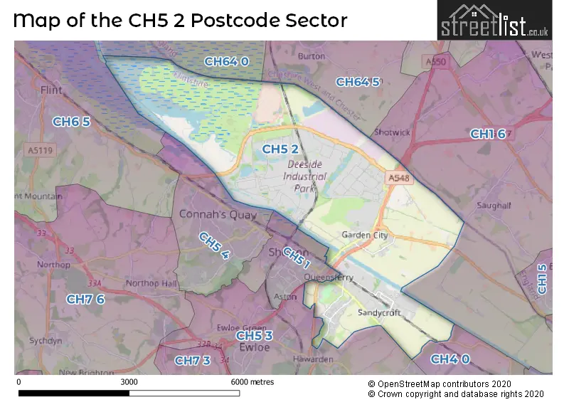
The CH5 2 postcode sector stands on the Cheshire and Clwyd border.
Did you know? According to the 2021 Census, the CH5 2 postcode sector is home to a bustling 7,196 residents!
Given that each sector allows for 400 unique postcode combinations. Letters C, I, K, M, O and V are not allowed in the last two letters of a postcode. With 223 postcodes already in use, this leaves 177 units available.
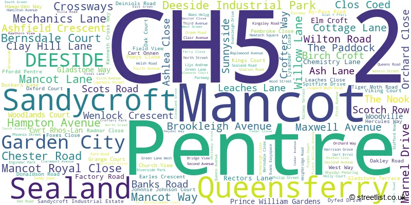
The largest settlement in the CH5 2 postal code is SEALAND followed by Mancot, and SANDYCROFT.
The CH5 2 Postcode shares a border with CH1 6 (Saughall, Mollington, Backford), CH4 0 (BROUGHTON, PENYFFORDD, PENYMYNYDD), CH64 5 (Burton, Puddington), CH64 0 (NESTON, Little Neston, Burton), CH5 1 (Shotton, Queensferry), CH5 3 (Hawarden, Ewloe, DOBSHILL) and CH5 4 (Connah's Quay, CONNAHS QUAY).
The sector is within the post town of DEESIDE.
CH5 2 is a postcode sector within the CH5 postcode district which is within the CH Chester postcode area.
The Royal Mail delivery office for the CH5 2 postal sector is the Deeside Delivery Office.
The area of the CH5 2 postcode sector is 11.35 square miles which is 29.39 square kilometres or 7,262.66 square acres.
The CH5 2 postcode sector is crossed by the A550 Major A road.
The CH5 2 postcode sector is crossed by the A494 Major A road.

Map of the CH5 2 Postcode Sector
Explore the CH5 2 postcode sector by using our free interactive map.
| C | H | 5 | - | 2 | X | X |
| C | H | 5 | Space | 2 | Letter | Letter |
Official List of Streets
Mancot (41 Streets)
Garden City (29 Streets)
Sealand (30 Streets)
Sandycroft (23 Streets)
Pentre (10 Streets)
Queensferry (6 Streets)
Deeside Industrial Park (11 Streets)
Unofficial Streets or Alternative Spellings
Sealand
OLD SEALAND ROAD ABRAHAM COURT ALVIS ROAD ANDREW COURT ASTON EXPRESSWAY BABBAGE ROAD BARTLET CLOSE BRACKENDALE ROAD CHESTER MILLENIUM GREENWAY CHESTER MILLENNIUM GREENWAY CHESTER ROAD (EAST) COATINGS BY PASS ROAD COATINGS TWO COLLIERY LANE CROSSING FROM P1 TO P2 CROSSTREE LANE DEE BRIDGE DEESIDE INDUSTRIAL PARK INTERCHANGE DRIVE A DRIVE B DRIVE C DRIVE D DROME CORNER INTERCHANGE EXPRESSWAY BUSINESS PARK FERRY BANK FFORD PENTRE FLINTSHIRE BRIDGE FOXS DRIVE GLENDALE AVENUE GREEN LANE (WEST) GREEN LANE EAST GREEN LANE ESTATE KENNINGTON CRESCENT LYONS YARD NORTH ROAD NR 568 QUEENSFERRY BYPASS QUEENSFERRY INDUSTRIAL ESTATE QUEENSFERRY INTERCHANGE RING ROAD RIVER DEE BRIDGE RIVER ROAD RIVERSIDE WAY SAINT BARTHOLOMEWS COURT SHOTWICK ROAD ST IVES WAY WESTWAY WHITE WAY GROVE WHITTLE CLOSE WOOD VILLE WOOLAND COURTChilder Thornton
WELSH ROADChester West Employment Park
SEALAND ROADMancot
CWRT RHOS-LANQueensferry
ASTON ROADHawarden
GLADSTONE WAY KENNEDY DRIVE MOOR LANE PARK AVENUE ROSSLYN CLOSESaughall
SEAHILL ROADWeather Forecast for CH5 2
Press Button to Show Forecast for Queensferry (Flintshire)
| Time Period | Icon | Description | Temperature | Rain Probability | Wind |
|---|---|---|---|---|---|
| 00:00 to 03:00 | Partly cloudy (night) | 12.0°C (feels like 12.0°C) | 0.00% | NW 2 mph | |
| 03:00 to 06:00 | Cloudy | 11.0°C (feels like 11.0°C) | 3.00% | SSE 2 mph | |
| 06:00 to 09:00 | Cloudy | 12.0°C (feels like 12.0°C) | 3.00% | SE 4 mph | |
| 09:00 to 12:00 | Cloudy | 18.0°C (feels like 17.0°C) | 3.00% | SE 7 mph | |
| 12:00 to 15:00 | Cloudy | 22.0°C (feels like 20.0°C) | 3.00% | SSE 7 mph | |
| 15:00 to 18:00 | Cloudy | 23.0°C (feels like 22.0°C) | 4.00% | SSE 7 mph | |
| 18:00 to 21:00 | Cloudy | 21.0°C (feels like 21.0°C) | 4.00% | S 4 mph | |
| 21:00 to 00:00 | Partly cloudy (night) | 17.0°C (feels like 16.0°C) | 0.00% | WSW 4 mph |
Press Button to Show Forecast for Queensferry (Flintshire)
| Time Period | Icon | Description | Temperature | Rain Probability | Wind |
|---|---|---|---|---|---|
| 00:00 to 03:00 | Clear night | 14.0°C (feels like 14.0°C) | 1.00% | W 2 mph | |
| 03:00 to 06:00 | Cloudy | 13.0°C (feels like 13.0°C) | 3.00% | S 2 mph | |
| 06:00 to 09:00 | Sunny day | 14.0°C (feels like 14.0°C) | 0.00% | SSE 4 mph | |
| 09:00 to 12:00 | Sunny day | 19.0°C (feels like 18.0°C) | 0.00% | SE 7 mph | |
| 12:00 to 15:00 | Partly cloudy (day) | 22.0°C (feels like 20.0°C) | 3.00% | SSE 9 mph | |
| 15:00 to 18:00 | Partly cloudy (day) | 22.0°C (feels like 20.0°C) | 1.00% | SSE 9 mph | |
| 18:00 to 21:00 | Partly cloudy (day) | 21.0°C (feels like 20.0°C) | 1.00% | SSE 7 mph | |
| 21:00 to 00:00 | Partly cloudy (night) | 17.0°C (feels like 16.0°C) | 1.00% | SSE 4 mph |
Press Button to Show Forecast for Queensferry (Flintshire)
| Time Period | Icon | Description | Temperature | Rain Probability | Wind |
|---|---|---|---|---|---|
| 00:00 to 03:00 | Clear night | 15.0°C (feels like 14.0°C) | 1.00% | SSE 7 mph | |
| 03:00 to 06:00 | Partly cloudy (night) | 13.0°C (feels like 13.0°C) | 0.00% | SE 7 mph | |
| 06:00 to 09:00 | Partly cloudy (day) | 14.0°C (feels like 13.0°C) | 1.00% | SE 7 mph | |
| 09:00 to 12:00 | Cloudy | 18.0°C (feels like 17.0°C) | 3.00% | SE 9 mph | |
| 12:00 to 15:00 | Cloudy | 21.0°C (feels like 19.0°C) | 7.00% | SSE 9 mph | |
| 15:00 to 18:00 | Cloudy | 21.0°C (feels like 20.0°C) | 18.00% | S 9 mph | |
| 18:00 to 21:00 | Light rain shower (day) | 19.0°C (feels like 18.0°C) | 38.00% | SW 7 mph | |
| 21:00 to 00:00 | Cloudy | 16.0°C (feels like 15.0°C) | 15.00% | W 7 mph |
Press Button to Show Forecast for Queensferry (Flintshire)
| Time Period | Icon | Description | Temperature | Rain Probability | Wind |
|---|---|---|---|---|---|
| 00:00 to 03:00 | Cloudy | 14.0°C (feels like 14.0°C) | 16.00% | W 7 mph | |
| 03:00 to 06:00 | Cloudy | 13.0°C (feels like 12.0°C) | 16.00% | WSW 7 mph | |
| 06:00 to 09:00 | Cloudy | 14.0°C (feels like 13.0°C) | 18.00% | SW 7 mph | |
| 09:00 to 12:00 | Cloudy | 16.0°C (feels like 14.0°C) | 19.00% | S 7 mph | |
| 12:00 to 15:00 | Light rain shower (day) | 17.0°C (feels like 15.0°C) | 43.00% | W 9 mph | |
| 15:00 to 18:00 | Heavy rain shower (day) | 17.0°C (feels like 15.0°C) | 59.00% | WSW 9 mph | |
| 18:00 to 21:00 | Light rain shower (day) | 15.0°C (feels like 14.0°C) | 41.00% | WSW 9 mph | |
| 21:00 to 00:00 | Cloudy | 13.0°C (feels like 12.0°C) | 13.00% | SSW 7 mph |
House Prices in the CH5 2 Postcode Sector
| Type of Property | 2018 Average | 2018 Sales | 2017 Average | 2017 Sales | 2016 Average | 2016 Sales | 2015 Average | 2015 Sales |
|---|---|---|---|---|---|---|---|---|
| Detached | £386,250 | 12 | £234,059 | 22 | £198,283 | 21 | £150,617 | 29 |
| Semi-Detached | £136,512 | 33 | £128,979 | 48 | £131,176 | 37 | £123,695 | 36 |
| Terraced | £108,067 | 30 | £112,395 | 41 | £106,722 | 27 | £99,905 | 33 |
| Flats | £83,500 | 2 | £0 | 0 | £0 | 0 | £48,750 | 2 |
Important Postcodes CH5 2 in the Postcode Sector
CH5 2EH is the postcode for Sandycroft Cp School, Leaches Lane
CH5 2EP is the postcode for Catherine Gladstone House, Hawarden Way, and Catherine Gladstone House, Catherine Gladstone House, Hawarden Way
CH5 2HH is the postcode for Sealand Cp School, Farm Road
CH5 2NS is the postcode for North Wales Police, Vehicle Commissioning Centre
CH5 2QX is the postcode for Parcelforce Worldwide, Unit 5-7, Factory Road, St. Ives Park, and Parcelforce Worldwide, Unit 6-7, St. Ives Park
| The CH5 2 Sector is within these Local Authorities |
|
|---|---|
| The CH5 2 Sector is within these Counties |
|
| The CH5 2 Sector is within these Water Company Areas |
|