The CH5 4 postcode sector is within the county of Clwyd.
Did you know? According to the 2021 Census, the CH5 4 postcode sector is home to a bustling 16,648 residents!
Given that each sector allows for 400 unique postcode combinations. Letters C, I, K, M, O and V are not allowed in the last two letters of a postcode. With 364 postcodes already in use, this leaves 36 units available.
The largest settlements in the CH5 4 postal code are Connah's Quay and CONNAHS QUAY.
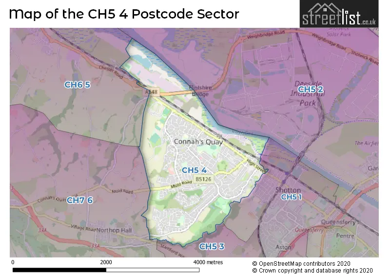
The CH5 4 Postcode shares a border with CH7 6 (MYNYDD ISA, NORTHOP HALL, NORTHOP), CH5 1 (Shotton, Queensferry), CH5 2 (SEALAND, Mancot, SANDYCROFT), CH5 3 (Hawarden, Ewloe, DOBSHILL) and CH6 5 (FLINT, OAKENHOLT, FLINT MOUNTAIN).
The sector is within the post town of DEESIDE.
CH5 4 is a postcode sector within the CH5 postcode district which is within the CH Chester postcode area.
The Royal Mail delivery office for the CH5 4 postal sector is the Deeside Delivery Office.
The area of the CH5 4 postcode sector is 2.57 square miles which is 6.65 square kilometres or 1,642.50 square acres.

Map of the CH5 4 Postcode Sector
Explore the CH5 4 postcode sector by using our free interactive map.
| C | H | 5 | - | 4 | X | X |
| C | H | 5 | Space | 4 | Letter | Letter |
Official List of Streets
Connah's Quay (284 Streets)
DEESIDE (1 Streets)
Unofficial Streets or Alternative Spellings
Shotton
KILLINS LANEWeather Forecast for CH5 4
Press Button to Show Forecast for Connah's Quay
| Time Period | Icon | Description | Temperature | Rain Probability | Wind |
|---|---|---|---|---|---|
| 03:00 to 06:00 | Cloudy | 4.0°C (feels like 3.0°C) | 5.00% | E 4 mph | |
| 06:00 to 09:00 | Partly cloudy (day) | 5.0°C (feels like 3.0°C) | 2.00% | E 4 mph | |
| 09:00 to 12:00 | Cloudy | 8.0°C (feels like 6.0°C) | 6.00% | E 7 mph | |
| 12:00 to 15:00 | Cloudy | 9.0°C (feels like 8.0°C) | 7.00% | E 7 mph | |
| 15:00 to 18:00 | Cloudy | 10.0°C (feels like 9.0°C) | 10.00% | NE 4 mph | |
| 18:00 to 21:00 | Cloudy | 10.0°C (feels like 8.0°C) | 7.00% | NE 4 mph | |
| 21:00 to 00:00 | Cloudy | 7.0°C (feels like 5.0°C) | 7.00% | NE 4 mph |
Press Button to Show Forecast for Connah's Quay
| Time Period | Icon | Description | Temperature | Rain Probability | Wind |
|---|---|---|---|---|---|
| 00:00 to 03:00 | Cloudy | 5.0°C (feels like 4.0°C) | 11.00% | E 4 mph | |
| 03:00 to 06:00 | Partly cloudy (night) | 4.0°C (feels like 3.0°C) | 8.00% | E 4 mph | |
| 06:00 to 09:00 | Cloudy | 5.0°C (feels like 3.0°C) | 10.00% | E 4 mph | |
| 09:00 to 12:00 | Cloudy | 8.0°C (feels like 6.0°C) | 10.00% | E 7 mph | |
| 12:00 to 15:00 | Overcast | 10.0°C (feels like 8.0°C) | 16.00% | ENE 9 mph | |
| 15:00 to 18:00 | Overcast | 11.0°C (feels like 9.0°C) | 20.00% | NE 9 mph | |
| 18:00 to 21:00 | Overcast | 10.0°C (feels like 8.0°C) | 19.00% | NE 9 mph | |
| 21:00 to 00:00 | Cloudy | 8.0°C (feels like 6.0°C) | 17.00% | NE 9 mph |
Press Button to Show Forecast for Connah's Quay
| Time Period | Icon | Description | Temperature | Rain Probability | Wind |
|---|---|---|---|---|---|
| 00:00 to 03:00 | Cloudy | 7.0°C (feels like 5.0°C) | 19.00% | NE 9 mph | |
| 03:00 to 06:00 | Cloudy | 7.0°C (feels like 4.0°C) | 19.00% | NNE 9 mph | |
| 06:00 to 09:00 | Light rain | 7.0°C (feels like 5.0°C) | 50.00% | NNE 9 mph | |
| 09:00 to 12:00 | Overcast | 9.0°C (feels like 7.0°C) | 20.00% | NNE 11 mph | |
| 12:00 to 15:00 | Cloudy | 11.0°C (feels like 8.0°C) | 27.00% | NNE 11 mph | |
| 15:00 to 18:00 | Light rain | 11.0°C (feels like 9.0°C) | 51.00% | N 11 mph | |
| 18:00 to 21:00 | Light rain shower (day) | 11.0°C (feels like 8.0°C) | 37.00% | N 11 mph | |
| 21:00 to 00:00 | Clear night | 8.0°C (feels like 6.0°C) | 10.00% | NW 9 mph |
House Prices in the CH5 4 Postcode Sector
| Type of Property | 2018 Average | 2018 Sales | 2017 Average | 2017 Sales | 2016 Average | 2016 Sales | 2015 Average | 2015 Sales |
|---|---|---|---|---|---|---|---|---|
| Detached | £196,186 | 79 | £209,363 | 109 | £189,442 | 89 | £190,507 | 95 |
| Semi-Detached | £137,517 | 112 | £127,764 | 116 | £125,820 | 123 | £119,346 | 122 |
| Terraced | £115,500 | 62 | £117,026 | 54 | £124,610 | 57 | £107,930 | 37 |
| Flats | £85,344 | 8 | £69,000 | 5 | £212,995 | 1 | £68,000 | 2 |
Important Postcodes CH5 4 in the Postcode Sector
CH5 4BH is the postcode for Connah's Quay High School, Golftyn Lane
CH5 4BR is the postcode for P16H BUILDING, Coleg Cambria, Kelsterton Road, HAIR, BEAUTY & NURSERY, Coleg Cambria, Kelsterton Road, LEARNING PATHWAYS, Coleg Cambria, Kelsterton Road, CONSTRUCTION BLOCK, Coleg Cambria, Kelsterton Road, DEESIDE HIGHER EDUCATION CENTRE, Coleg Cambria, Kelsterton Road, MAIN BLOCK, Coleg Cambria, Kelsterton Road, and STADIUM CHANGING ROOMS, Coleg Cambria, Kelsterton Road
CH5 4HA is the postcode for Connah's Quay Civic Hall, Wepre Drive, Jobcentre Plus, Civic Centre, Wepre Drive, Flintshire County Council, Civic Centre, Wepre Drive, and Connah's Quay Pool, Wepre Drive
CH5 4HL is the postcode for Wepre Park Visitors Centre, Wepre Park
CH5 4NE is the postcode for Wepre Lane Cp School, Llwyni Drive
CH5 4PJ is the postcode for The Quay Health Centre, Fron Road, and Connahs Quay Resource Centre, The Quay Health Centre, Fron Road
CH5 4QL is the postcode for Ysgol Caernant CP School, Mold Road, and Custom House Lane Cp School, Mold Road
CH5 4SN is the postcode for Bryn Deva Cp School, Linden Avenue
CH5 4SX is the postcode for Red Hall Hotel, Englefield Avenue
CH5 4XA is the postcode for Golftyn Cp School, York Road
| The CH5 4 Sector is within these Local Authorities |
|
|---|---|
| The CH5 4 Sector is within these Counties |
|
| The CH5 4 Sector is within these Water Company Areas |
|