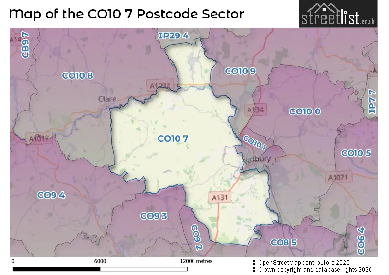
The CO10 7 postcode sector stands on the Essex and Suffolk border.
Did you know? According to the 2021 Census, the CO10 7 postcode sector is home to a bustling 6,931 residents!
Given that each sector allows for 400 unique postcode combinations. Letters C, I, K, M, O and V are not allowed in the last two letters of a postcode. With 255 postcodes already in use, this leaves 145 units available.
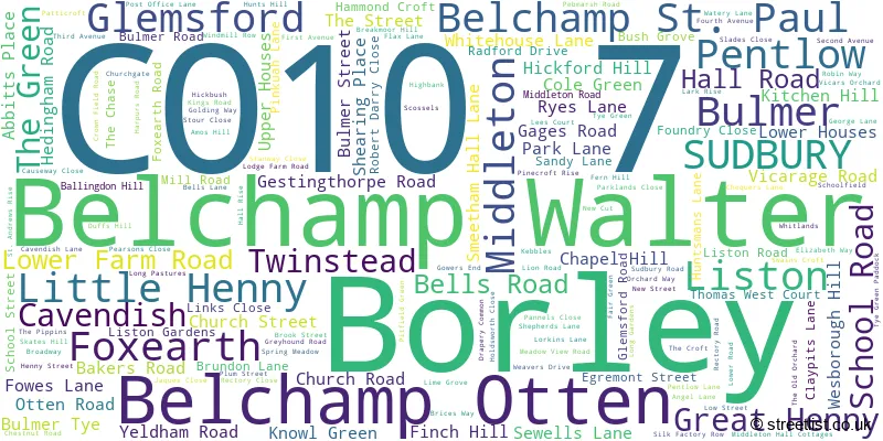
The largest settlement in the CO10 7 postal code is Glemsford followed by Bulmer, and SUDBURY.
The CO10 7 Postcode shares a border with CO8 5 (BURES, Mount Bures, Alphamstone), CO9 2 (HALSTEAD, Pebmarsh, Great Maplestead), CO9 3 (Sible Hedingham, Castle Hedingham, Gestingthorpe), CO9 4 (Great Yeldham, Toppesfield, Ridgewell), CO10 0 (Great Cornard, Acton, Great Waldingfield), CO10 1 (SUDBURY), CO10 2 (SUDBURY, Chilton Industrial Estate), CO10 8 (Clare, Hundon, Cavendish), CO10 9 (Long Melford, Lavenham, Stanstead) and IP29 4 (Lawshall, Chedburgh, Whepstead).
The sector is within the post town of SUDBURY.
CO10 7 is a postcode sector within the CO1 postcode district which is within the CO Colchester postcode area.
The Royal Mail delivery office for the CO10 7 postal sector is the unknown.
The area of the CO10 7 postcode sector is 31.66 square miles which is 82.01 square kilometres or 20,264.10 square acres.
Waterways within the CO10 7 postcode sector include the River Stour, River Glem, Belchamp Brook.

Map of the CO10 7 Postcode Sector
Explore the CO10 7 postcode sector by using our free interactive map.
| C | O | 1 | 0 | - | 7 | X | X |
| C | O | 1 | 0 | Space | 7 | Letter | Letter |
Official List of Streets
Glemsford (72 Streets)
Great Henny (3 Streets)
Belchamp St. Paul (8 Streets)
SUDBURY (15 Streets)
Belchamp Walter (5 Streets)
Pentlow (4 Streets)
Middleton (3 Streets)
Bulmer (16 Streets)
Twinstead (5 Streets)
Belchamp Otten (7 Streets)
Foxearth (7 Streets)
Liston (3 Streets)
Borley (4 Streets)
Cavendish (1 Streets)
Little Henny (2 Streets)
Unofficial Streets or Alternative Spellings
Gestingthorpe
NETHER HILL SUDBURY ROADLong Melford
BORLEY ROAD LISTON LANECavendish
MELFORD ROADLittle Yeldham
BELCHAMP ROAD MASHAY ROADLamarsh
TWINSTEAD ROADWickham St. Paul
BROAD ROAD CATLEY CROSS OLD ROADWeather Forecast for CO10 7
Press Button to Show Forecast for Belchamp Otten
| Time Period | Icon | Description | Temperature | Rain Probability | Wind |
|---|---|---|---|---|---|
| 15:00 to 18:00 | Partly cloudy (day) | 16.0°C (feels like 12.0°C) | 0.00% | SSW 18 mph | |
| 18:00 to 21:00 | Sunny day | 13.0°C (feels like 11.0°C) | 0.00% | S 11 mph | |
| 21:00 to 00:00 | Clear night | 9.0°C (feels like 7.0°C) | 0.00% | SSE 9 mph |
Press Button to Show Forecast for Belchamp Otten
| Time Period | Icon | Description | Temperature | Rain Probability | Wind |
|---|---|---|---|---|---|
| 00:00 to 03:00 | Clear night | 8.0°C (feels like 6.0°C) | 0.00% | SE 7 mph | |
| 03:00 to 06:00 | Partly cloudy (night) | 7.0°C (feels like 5.0°C) | 1.00% | SE 7 mph | |
| 06:00 to 09:00 | Sunny day | 10.0°C (feels like 8.0°C) | 1.00% | SE 7 mph | |
| 09:00 to 12:00 | Partly cloudy (day) | 15.0°C (feels like 13.0°C) | 3.00% | SE 11 mph | |
| 12:00 to 15:00 | Cloudy | 15.0°C (feels like 13.0°C) | 8.00% | SE 11 mph | |
| 15:00 to 18:00 | Cloudy | 15.0°C (feels like 13.0°C) | 8.00% | SSE 13 mph | |
| 18:00 to 21:00 | Cloudy | 14.0°C (feels like 12.0°C) | 11.00% | SE 9 mph | |
| 21:00 to 00:00 | Cloudy | 11.0°C (feels like 10.0°C) | 12.00% | SE 7 mph |
Press Button to Show Forecast for Belchamp Otten
| Time Period | Icon | Description | Temperature | Rain Probability | Wind |
|---|---|---|---|---|---|
| 00:00 to 03:00 | Cloudy | 10.0°C (feels like 9.0°C) | 11.00% | SE 4 mph | |
| 03:00 to 06:00 | Mist | 10.0°C (feels like 9.0°C) | 21.00% | SE 4 mph | |
| 06:00 to 09:00 | Cloudy | 11.0°C (feels like 10.0°C) | 12.00% | E 2 mph | |
| 09:00 to 12:00 | Cloudy | 14.0°C (feels like 13.0°C) | 9.00% | NE 4 mph | |
| 12:00 to 15:00 | Cloudy | 16.0°C (feels like 16.0°C) | 19.00% | NE 7 mph | |
| 15:00 to 18:00 | Cloudy | 17.0°C (feels like 16.0°C) | 8.00% | ENE 9 mph | |
| 18:00 to 21:00 | Cloudy | 15.0°C (feels like 14.0°C) | 7.00% | NNW 9 mph | |
| 21:00 to 00:00 | Overcast | 12.0°C (feels like 10.0°C) | 12.00% | NNW 9 mph |
Press Button to Show Forecast for Belchamp Otten
| Time Period | Icon | Description | Temperature | Rain Probability | Wind |
|---|---|---|---|---|---|
| 00:00 to 03:00 | Overcast | 11.0°C (feels like 9.0°C) | 19.00% | NNW 9 mph | |
| 03:00 to 06:00 | Cloudy | 10.0°C (feels like 8.0°C) | 10.00% | NNW 9 mph | |
| 06:00 to 09:00 | Cloudy | 11.0°C (feels like 9.0°C) | 8.00% | NW 9 mph | |
| 09:00 to 12:00 | Partly cloudy (day) | 15.0°C (feels like 13.0°C) | 4.00% | NNW 9 mph | |
| 12:00 to 15:00 | Partly cloudy (day) | 18.0°C (feels like 16.0°C) | 4.00% | NNW 11 mph | |
| 15:00 to 18:00 | Partly cloudy (day) | 18.0°C (feels like 16.0°C) | 4.00% | N 11 mph | |
| 18:00 to 21:00 | Sunny day | 16.0°C (feels like 14.0°C) | 3.00% | WNW 9 mph | |
| 21:00 to 00:00 | Partly cloudy (night) | 12.0°C (feels like 10.0°C) | 3.00% | NNW 9 mph |
Schools and Places of Education Within the CO10 7 Postcode Sector
Belchamp St Paul Church of England Primary School
Academy converter
Vicarage Road, Sudbury, Suffolk, CO10 7BP
Head: Ana Da Piedade
Ofsted Rating: Good
Inspection: 2022-02-10 (809 days ago)
Website: Visit Belchamp St Paul Church of England Primary School Website
Phone: 01787277222
Number of Pupils: 64
Glemsford Primary Academy
Academy sponsor led
Lion Road, Sudbury, Suffolk, CO10 7RF
Head: Mr Nicolas George
Ofsted Rating: Good
Inspection: 2023-04-20 (375 days ago)
Website: Visit Glemsford Primary Academy Website
Phone: 01787283200
Number of Pupils: 236
St Andrew's Bulmer Church of England Voluntary Controlled Primary School
Voluntary controlled school
Church Road, Sudbury, Essex, CO10 7EH
Head: Mrs Jinnie Nichols
Ofsted Rating: Good
Inspection: 2018-03-15 (2237 days ago)
Website: Visit St Andrew's Bulmer Church of England Voluntary Controlled Primary School Website
Phone: 01787372383
Number of Pupils: 72
House Prices in the CO10 7 Postcode Sector
| Type of Property | 2018 Average | 2018 Sales | 2017 Average | 2017 Sales | 2016 Average | 2016 Sales | 2015 Average | 2015 Sales |
|---|---|---|---|---|---|---|---|---|
| Detached | £438,785 | 38 | £412,574 | 60 | £394,966 | 59 | £378,427 | 49 |
| Semi-Detached | £252,445 | 36 | £287,372 | 43 | £257,657 | 44 | £214,515 | 34 |
| Terraced | £210,896 | 24 | £215,251 | 33 | £177,518 | 44 | £166,559 | 33 |
| Flats | £106,857 | 7 | £103,499 | 9 | £123,153 | 13 | £59,938 | 8 |
Important Postcodes CO10 7 in the Postcode Sector
CO10 7BP is the postcode for BELCHAMP ST PAUL CHURCH OF ENGLAND PRIMARY SCHOOL, VICARAGE ROAD, BELCHAMP ST PAUL
CO10 7RF is the postcode for Glemsford Primary Academy, Lion Road, The Surgery, Lion Road, Glemsford Cp School, Lion Road, and Glemsford Cp School, Lion Road, Glemsford
| The CO10 7 Sector is within these Local Authorities |
|
|---|---|
| The CO10 7 Sector is within these Counties |
|
| The CO10 7 Sector is within these Water Company Areas |
|