The CV10 7 postcode sector is within the county of Warwickshire.
Did you know? According to the 2021 Census, the CV10 7 postcode sector is home to a bustling 12,034 residents!
Given that each sector allows for 400 unique postcode combinations. Letters C, I, K, M, O and V are not allowed in the last two letters of a postcode. With 234 postcodes already in use, this leaves 166 units available.
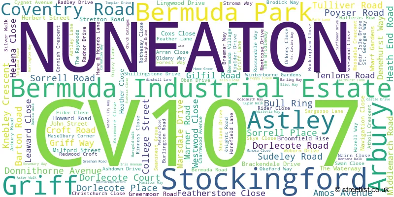
The largest settlement in the CV10 7 postal code is NUNEATON followed by Astley, and Bermuda Park.
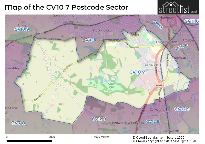
The CV10 7 Postcode shares a border with CV10 8 (NUNEATON), CV10 9 (NUNEATON, Galley Common, Ansley), CV11 4 (NUNEATON, Attleborough), CV12 0 (BEDWORTH), CV7 8 (Keresley End, Fillongley, Arley), CV11 5 (NUNEATON, Coton), CV12 8 (BEDWORTH) and CV12 9 (Bulkington, BEDWORTH, Marston Jabbett).
The sector is within the post town of NUNEATON.
CV10 7 is a postcode sector within the CV10 postcode district which is within the CV Coventry postcode area.
The Royal Mail delivery office for the CV10 7 postal sector is the Nuneaton Delivery Office.
The area of the CV10 7 postcode sector is 7.88 square miles which is 20.41 square kilometres or 5,043.58 square acres.
Waterways within the CV10 7 postcode sector include the Coventry Canal.

Map of the CV10 7 Postcode Sector
Explore the CV10 7 postcode sector by using our free interactive map.
| C | V | 1 | 0 | - | 7 | X | X |
| C | V | 1 | 0 | Space | 7 | Letter | Letter |
Official List of Streets
NUNEATON (118 Streets)
Astley (6 Streets)
Bermuda Industrial Estate (3 Streets)
Griff (2 Streets)
Bermuda Park (4 Streets)
Arbury (1 Streets)
Stockingford (1 Streets)
Unofficial Streets or Alternative Spellings
NUNEATON
CAMBRIDGE DRIVE CHURCH ROAD GROVE ROAD NORTH STREET NORTHUMBERLAND AVENUE PARK LANE PRIORY STREET TOMKINSON ROAD WESTBURY ROAD ALBERT STREET ATHOL CLOSE BEDWORTH BYPASS BELLE VUE BERMUDA PARK CAT GALLOWS BRIDGE CHILVERS RISE CHURCH LANE GRIFF ROUNDABOUT HARE AND HOUNDS LANE HARMONY COURT HOWE GREEN LANE POST OFFICE ROW RED DEEPS AND WEM MEADOWS RED LANE ROSE GARDENS RUNNYMEDE GARDENS THE POPLARS TURN OVER BRIDGERobinsons End
ANSLEY ROADGun Hill
ARLEY LANEAnsley
BIRMINGHAM ROADWeather Forecast for CV10 7
Press Button to Show Forecast for Goodyers End
| Time Period | Icon | Description | Temperature | Rain Probability | Wind |
|---|---|---|---|---|---|
| 15:00 to 18:00 | Overcast | 8.0°C (feels like 5.0°C) | 44.00% | NE 11 mph | |
| 18:00 to 21:00 | Overcast | 8.0°C (feels like 4.0°C) | 13.00% | NE 11 mph | |
| 21:00 to 00:00 | Light rain | 6.0°C (feels like 3.0°C) | 82.00% | NE 13 mph |
Press Button to Show Forecast for Goodyers End
| Time Period | Icon | Description | Temperature | Rain Probability | Wind |
|---|---|---|---|---|---|
| 00:00 to 03:00 | Heavy rain | 6.0°C (feels like 2.0°C) | 89.00% | NNE 13 mph | |
| 03:00 to 06:00 | Heavy rain | 6.0°C (feels like 2.0°C) | 94.00% | N 16 mph | |
| 06:00 to 09:00 | Heavy rain | 6.0°C (feels like 1.0°C) | 94.00% | NNW 13 mph | |
| 09:00 to 12:00 | Heavy rain | 5.0°C (feels like 1.0°C) | 84.00% | NW 13 mph | |
| 12:00 to 15:00 | Heavy rain | 6.0°C (feels like 2.0°C) | 83.00% | WNW 13 mph | |
| 15:00 to 18:00 | Cloudy | 8.0°C (feels like 5.0°C) | 55.00% | W 11 mph | |
| 18:00 to 21:00 | Partly cloudy (day) | 9.0°C (feels like 7.0°C) | 9.00% | WSW 9 mph | |
| 21:00 to 00:00 | Clear night | 6.0°C (feels like 4.0°C) | 0.00% | SW 7 mph |
Press Button to Show Forecast for Goodyers End
| Time Period | Icon | Description | Temperature | Rain Probability | Wind |
|---|---|---|---|---|---|
| 00:00 to 03:00 | Clear night | 5.0°C (feels like 2.0°C) | 0.00% | SSW 9 mph | |
| 03:00 to 06:00 | Clear night | 4.0°C (feels like 1.0°C) | 1.00% | SSW 7 mph | |
| 06:00 to 09:00 | Sunny day | 5.0°C (feels like 2.0°C) | 1.00% | S 9 mph | |
| 09:00 to 12:00 | Partly cloudy (day) | 10.0°C (feels like 8.0°C) | 2.00% | S 13 mph | |
| 12:00 to 15:00 | Cloudy | 13.0°C (feels like 10.0°C) | 7.00% | S 16 mph | |
| 15:00 to 18:00 | Partly cloudy (day) | 14.0°C (feels like 11.0°C) | 5.00% | S 16 mph | |
| 18:00 to 21:00 | Partly cloudy (day) | 13.0°C (feels like 10.0°C) | 3.00% | S 13 mph | |
| 21:00 to 00:00 | Clear night | 10.0°C (feels like 7.0°C) | 2.00% | SSE 11 mph |
Press Button to Show Forecast for Goodyers End
| Time Period | Icon | Description | Temperature | Rain Probability | Wind |
|---|---|---|---|---|---|
| 00:00 to 03:00 | Clear night | 8.0°C (feels like 6.0°C) | 1.00% | SSE 9 mph | |
| 03:00 to 06:00 | Clear night | 7.0°C (feels like 4.0°C) | 1.00% | SE 9 mph | |
| 06:00 to 09:00 | Sunny day | 8.0°C (feels like 5.0°C) | 2.00% | SE 9 mph | |
| 09:00 to 12:00 | Sunny day | 13.0°C (feels like 10.0°C) | 2.00% | SE 11 mph | |
| 12:00 to 15:00 | Partly cloudy (day) | 15.0°C (feels like 13.0°C) | 4.00% | SE 13 mph | |
| 15:00 to 18:00 | Partly cloudy (day) | 16.0°C (feels like 13.0°C) | 6.00% | SE 13 mph | |
| 18:00 to 21:00 | Cloudy | 15.0°C (feels like 13.0°C) | 9.00% | SE 9 mph | |
| 21:00 to 00:00 | Partly cloudy (night) | 11.0°C (feels like 10.0°C) | 6.00% | ESE 7 mph |
Press Button to Show Forecast for Goodyers End
| Time Period | Icon | Description | Temperature | Rain Probability | Wind |
|---|---|---|---|---|---|
| 00:00 to 03:00 | Cloudy | 10.0°C (feels like 9.0°C) | 10.00% | ESE 7 mph | |
| 03:00 to 06:00 | Cloudy | 10.0°C (feels like 8.0°C) | 13.00% | E 4 mph | |
| 06:00 to 09:00 | Cloudy | 10.0°C (feels like 9.0°C) | 15.00% | E 7 mph | |
| 09:00 to 12:00 | Overcast | 13.0°C (feels like 12.0°C) | 16.00% | E 7 mph | |
| 12:00 to 15:00 | Cloudy | 15.0°C (feels like 14.0°C) | 17.00% | E 7 mph | |
| 15:00 to 18:00 | Light rain shower (day) | 16.0°C (feels like 15.0°C) | 39.00% | E 7 mph | |
| 18:00 to 21:00 | Light rain shower (day) | 15.0°C (feels like 14.0°C) | 33.00% | ESE 7 mph | |
| 21:00 to 00:00 | Cloudy | 13.0°C (feels like 11.0°C) | 14.00% | E 7 mph |
Schools and Places of Education Within the CV10 7 Postcode Sector
All Saints CofE Primary School and Nursery, Nuneaton
Voluntary controlled school
Knebley Crescent, Nuneaton, Warwickshire, CV10 7AT
Head: Mrs Lisa Harrison
Ofsted Rating: Good
Inspection: 2019-12-18 (1592 days ago)
Website: Visit All Saints CofE Primary School and Nursery, Nuneaton Website
Phone: 02476382123
Number of Pupils: 245
Glendale Infant School
Community school
Skye Close, Nuneaton, Warwickshire, CV10 7LW
Head: Mrs Louise Hopkins
Ofsted Rating: Good
Inspection: 2023-07-04 (298 days ago)
Website: Visit Glendale Infant School Website
Phone: 02476349672
Number of Pupils: 269
Middlemarch School
Foundation school
College Street, Nuneaton, Warwickshire, CV10 7BQ
Head: Mrs G Mawdsley
Ofsted Rating: Good
Inspection: 2019-04-03 (1851 days ago)
Website: Visit Middlemarch School Website
Phone: 02476328009
Number of Pupils: 194
St Thomas More Catholic School and Sixth Form College
Academy converter
Greenmoor Road, Nuneaton, Warwickshire, CV10 7EX
Head: Mrs Leearna Thomas
Ofsted Rating: Good
Inspection: 2023-05-24 (339 days ago)
Website: Visit St Thomas More Catholic School and Sixth Form College Website
Phone: 02476642400
Number of Pupils: 1045
House Prices in the CV10 7 Postcode Sector
| Type of Property | 2018 Average | 2018 Sales | 2017 Average | 2017 Sales | 2016 Average | 2016 Sales | 2015 Average | 2015 Sales |
|---|---|---|---|---|---|---|---|---|
| Detached | £228,881 | 49 | £242,748 | 40 | £215,732 | 42 | £202,007 | 53 |
| Semi-Detached | £162,324 | 88 | £150,962 | 86 | £135,840 | 55 | £139,650 | 56 |
| Terraced | £135,454 | 74 | £135,443 | 80 | £126,472 | 80 | £122,802 | 89 |
| Flats | £107,075 | 16 | £94,692 | 18 | £89,350 | 15 | £86,585 | 10 |
Important Postcodes CV10 7 in the Postcode Sector
CV10 7AD is the postcode for MAIN BLOCK, All Saints C of E Primary School, Coventry Road
CV10 7AT is the postcode for All Saints C of E Primary School & Nursery, Knebley Crescent
CV10 7BQ is the postcode for MAIN BUILDING, Middlemarch County Junior School, College Street, and Middlemarch County Junior School, College Street
CV10 7DJ is the postcode for George Eliot Hospital, PHASE 2, The George Eliot Hospital NHS Trust, Lewis House, College Street, PHASE 3, The George Eliot Hospital NHS Trust, Lewis House, College Street, GETEC, The George Eliot Hospital NHS Trust, Lewis House, College Street, George Eliot Hospital, College Street, RENAL UNIT, George Eliot Hospital, COOMBE HOUSE, George Eliot Hospital, The George Eliot Hospital NHS Trust, Lewis House, College Street, Maternity Unit, George Eliot Hospital, College Street, MATERNITY BLOCK, The George Eliot Hospital NHS Trust, Lewis House, College Street, MATERNITY BLOCK, George Eliot Hospital, CHEVERAL WING, The George Eliot Hospital NHS Trust, Lewis House, College Street, and CATERING BLOCK, The George Eliot Hospital NHS Trust, Lewis House, College Street
CV10 7EL is the postcode for Jubilee Sports Centre, Greenmoor Road
CV10 7EX is the postcode for TECHNOLOGY BLOCK, St. Thomas More School, Greenmoor Road, SIXTH FORM BLOCK, St. Thomas More School, Greenmoor Road, and MAIN BLOCK, St. Thomas More School, Greenmoor Road
CV10 7LW is the postcode for MAIN BUILDING, Glendale Infant School, Skye Close, and Glendale Infant School, Skye Close
CV10 7PD is the postcode for SEESWOOD, Nuneaton Academy, Radnor Drive, CENTRAL BLOCK, Nuneaton Academy, Radnor Drive, A BLOCK, Nuneaton Academy, Radnor Drive, RADNOR, Nuneaton Academy, Radnor Drive, SPORTS HALL, Nuneaton Academy, Radnor Drive, DERWENT, Nuneaton Academy, Radnor Drive, H BLOCK, Nuneaton Academy, Radnor Drive, F BLOCK, Nuneaton Academy, Radnor Drive, B BLOCK, Nuneaton Academy, Radnor Drive, and C BLOCK, Nuneaton Academy, Radnor Drive
CV10 7RH is the postcode for Discovery House, 5 Barling Way
CV10 7SD is the postcode for Midland Studio College Nuneaton, Bermuda Park Innovation Centre, North Warwickshire & Hinckley College, Bermuda Park Innovation Centre, and INNOVATION CENTRE, North Warwickshire & Hinckley College, Bermuda Park Innovation Centre
| The CV10 7 Sector is within these Local Authorities |
|
|---|---|
| The CV10 7 Sector is within these Counties |
|
| The CV10 7 Sector is within these Water Company Areas |
|