The DA12 1 postcode sector is within the county of Kent.
Did you know? According to the 2021 Census, the DA12 1 postcode sector is home to a bustling 6,836 residents!
Given that each sector allows for 400 unique postcode combinations. Letters C, I, K, M, O and V are not allowed in the last two letters of a postcode. With 155 postcodes already in use, this leaves 245 units available.
The DA12 1 postal code covers the settlement of GRAVESEND.
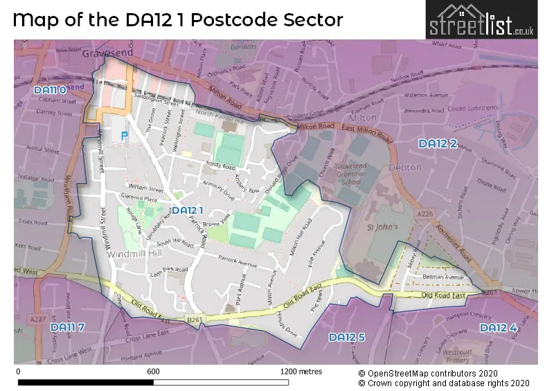
The DA12 1 Postcode shares a border with DA11 7 (GRAVESEND, Northfleet), DA12 2 (GRAVESEND), DA12 5 (GRAVESEND), DA11 0 (GRAVESEND) and DA12 4 (GRAVESEND).
The sector is within the post town of GRAVESEND.
DA12 1 is a postcode sector within the DA12 postcode district which is within the DA Dartford postcode area.
The Royal Mail delivery office for the DA12 1 postal sector is the Gravesend Delivery Office.
The area of the DA12 1 postcode sector is 0.44 square miles which is 1.15 square kilometres or 283.90 square acres.

Map of the DA12 1 Postcode Sector
Explore the DA12 1 postcode sector by using our free interactive map.
| D | A | 1 | 2 | - | 1 | X | X |
| D | A | 1 | 2 | Space | 1 | Letter | Letter |
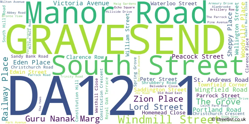
Official List of Streets
GRAVESEND (62 Streets)
Unofficial Streets or Alternative Spellings
GRAVESEND
AUGUSTINE ROAD BROWN ROAD CHURCH WALK CLIVE ROAD CROSS LANE EAST DEVONSHIRE ROAD DONALD BIGGS DRIVE ESSEX ROAD LORTON CLOSE MILTON ROAD OLD ROAD WEST PROSPECT GROVE RATHMORE ROAD SINGLEWELL ROAD STONE STREET SUN LANE THE TURNSTONES VALLEY DRIVE WHITEHILL ROAD ATHBOY ROAD BLENHEIM GROVE CHRIST CHURCH CRESCENT CHRIST CHURCH ROAD GRAVESHAM COURT HOME MEAD CLOSE HOMEMEAD KHALSA AVENUE LARKIN LANE MILTON COURT NORTH STREET POUNDFIELD WALK ROUGE LANEIstead Rise
WROTHAM ROADWeather Forecast for DA12 1
Press Button to Show Forecast for Gravesend
| Time Period | Icon | Description | Temperature | Rain Probability | Wind |
|---|---|---|---|---|---|
| 00:00 to 03:00 | Cloudy | 7.0°C (feels like 4.0°C) | 7.00% | NE 7 mph | |
| 03:00 to 06:00 | Cloudy | 6.0°C (feels like 3.0°C) | 5.00% | NE 7 mph | |
| 06:00 to 09:00 | Cloudy | 6.0°C (feels like 3.0°C) | 5.00% | NE 7 mph | |
| 09:00 to 12:00 | Cloudy | 8.0°C (feels like 6.0°C) | 5.00% | ENE 7 mph | |
| 12:00 to 15:00 | Cloudy | 9.0°C (feels like 7.0°C) | 7.00% | E 7 mph | |
| 15:00 to 18:00 | Cloudy | 10.0°C (feels like 8.0°C) | 11.00% | E 9 mph | |
| 18:00 to 21:00 | Cloudy | 9.0°C (feels like 7.0°C) | 11.00% | E 9 mph | |
| 21:00 to 00:00 | Cloudy | 8.0°C (feels like 5.0°C) | 13.00% | E 9 mph |
Press Button to Show Forecast for Gravesend
| Time Period | Icon | Description | Temperature | Rain Probability | Wind |
|---|---|---|---|---|---|
| 00:00 to 03:00 | Light rain | 7.0°C (feels like 5.0°C) | 45.00% | E 9 mph | |
| 03:00 to 06:00 | Light rain | 7.0°C (feels like 5.0°C) | 48.00% | ENE 9 mph | |
| 06:00 to 09:00 | Overcast | 8.0°C (feels like 5.0°C) | 23.00% | ENE 11 mph | |
| 09:00 to 12:00 | Cloudy | 10.0°C (feels like 8.0°C) | 21.00% | E 11 mph | |
| 12:00 to 15:00 | Cloudy | 12.0°C (feels like 10.0°C) | 18.00% | E 11 mph | |
| 15:00 to 18:00 | Light rain shower (day) | 12.0°C (feels like 10.0°C) | 37.00% | E 11 mph | |
| 18:00 to 21:00 | Light rain | 11.0°C (feels like 9.0°C) | 52.00% | E 11 mph | |
| 21:00 to 00:00 | Light rain | 10.0°C (feels like 8.0°C) | 51.00% | E 11 mph |
Press Button to Show Forecast for Gravesend
| Time Period | Icon | Description | Temperature | Rain Probability | Wind |
|---|---|---|---|---|---|
| 00:00 to 03:00 | Light rain | 10.0°C (feels like 8.0°C) | 54.00% | E 9 mph | |
| 03:00 to 06:00 | Light rain | 10.0°C (feels like 8.0°C) | 54.00% | E 9 mph | |
| 06:00 to 09:00 | Light rain | 10.0°C (feels like 8.0°C) | 48.00% | SE 9 mph | |
| 09:00 to 12:00 | Light rain shower (day) | 11.0°C (feels like 9.0°C) | 43.00% | SSE 11 mph | |
| 12:00 to 15:00 | Light rain shower (day) | 13.0°C (feels like 10.0°C) | 41.00% | S 13 mph | |
| 15:00 to 18:00 | Heavy rain shower (day) | 14.0°C (feels like 11.0°C) | 52.00% | S 11 mph | |
| 18:00 to 21:00 | Light rain shower (day) | 13.0°C (feels like 11.0°C) | 36.00% | SSW 9 mph | |
| 21:00 to 00:00 | Partly cloudy (night) | 10.0°C (feels like 9.0°C) | 6.00% | S 9 mph |
Schools and Places of Education Within the DA12 1 Postcode Sector
Holy Trinity Church of England Primary School
Academy converter
Trinity Road, Gravesend, Kent, DA12 1LU
Head: Mrs Pamela Gough
Ofsted Rating: Good
Inspection: 2023-10-04 (205 days ago)
Website: Visit Holy Trinity Church of England Primary School Website
Phone: 01474534746
Number of Pupils: 457
House Prices in the DA12 1 Postcode Sector
| Type of Property | 2018 Average | 2018 Sales | 2017 Average | 2017 Sales | 2016 Average | 2016 Sales | 2015 Average | 2015 Sales |
|---|---|---|---|---|---|---|---|---|
| Detached | £530,778 | 9 | £563,000 | 13 | £475,731 | 13 | £414,514 | 7 |
| Semi-Detached | £413,445 | 18 | £392,119 | 21 | £384,809 | 21 | £282,925 | 20 |
| Terraced | £284,186 | 35 | £296,286 | 43 | £250,590 | 39 | £221,010 | 54 |
| Flats | £171,458 | 30 | £157,993 | 57 | £161,660 | 64 | £132,444 | 36 |
Important Postcodes DA12 1 in the Postcode Sector
DA12 1AU is the postcode for Gravesham Borough Council, Civic Centre, Windmill Street, and St Georges Art Centre, Gravesham Borough Council, Civic Centre, Windmill Street
DA12 1BE is the postcode for Gravesend Library, Windmill Street, Kent County Council, Gravesend Library, Windmill Street, and GRAVESEND LIBRARY, WINDMILL STREET, GRAVESEND
DA12 1BQ is the postcode for 132 Windmill Street
DA12 1DF is the postcode for 44-46 The Grove, and Benefits Agency, 44-46, The Grove
DA12 1DS is the postcode for H M Revenue & Customs, Stephenson House, 7-10 The Grove
DA12 1LU is the postcode for FOUR CLASSROOM BLOCK, Holy Trinity C of E School, Trinity Road, NURSERY, Holy Trinity C of E School, Trinity Road, Holy Trinity C Of E Primary School, Trinity Road, Guru Nanak Day Centre, Trinity Road, THE STUDIO, Holy Trinity C of E School, Trinity Road, and Holy Trinity C of E School, Trinity Road
DA12 1NE is the postcode for Kent County Council, Social Education Centre, Haig Gardens
| The DA12 1 Sector is within these Local Authorities |
|
|---|---|
| The DA12 1 Sector is within these Counties |
|
| The DA12 1 Sector is within these Water Company Areas |
|