The DA12 postcode district is a postal district located in the DA Dartford postcode area with a population of 49,484 residents according to the 2021 England and Wales Census.
The area of the DA12 postcode district is 12.22 square miles which is 31.64 square kilometres or 7,819.00 acres.
Currently, the DA12 district has about 979 postcode units spread across 5 geographic postcode sectors.
Given that each sector allows for 400 unique postcode combinations, the district has a capacity of 2,000 postcodes. With 979 postcodes already in use, this leaves 1021 units available.
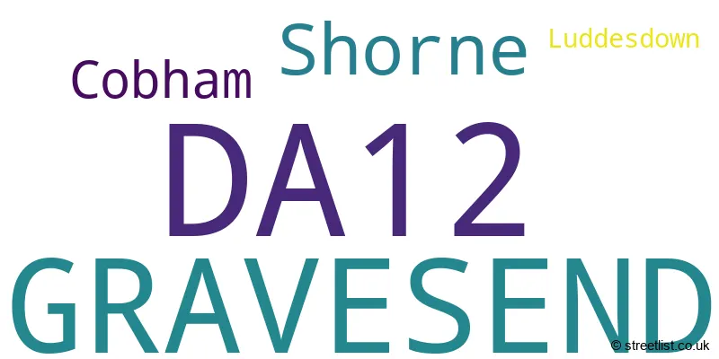
The largest settlement in the DA12 postal code is GRAVESEND followed by Shorne, and Cobham.
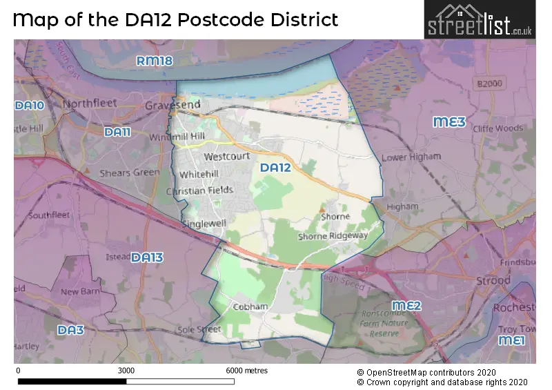
The postcode area has a boundary with Tidal Thames.
The DA12 Postcode shares a border with DA11 (Northfleet, GRAVESEND), DA13 (Meopham, Istead Rise, Southfleet) and ME3 (Hoo, Higham, Cliffe).
The primary settlement in the DA12 postcode district is Gravesend, located in the county of Kent, England. Additionally, there are other significant settlements such as Cobham, Luddesdown, and Shorne within the same postcode district. The primary post town in the DA12 district is Gravesend as well.
For the district DA12, we have data on 6 postcode sectors. Here's a breakdown: The sector DA12 1, covers Gravesend in Kent. The sector DA12 2, covers Gravesend in Kent. The sector DA12 3, covers Shorne and Cobham in Kent. The sector DA12 4, covers Gravesend in Kent. The sector DA12 5, covers Gravesend in Kent. The sector DA12 9 is non-geographic. It's often designated for PO Boxes, large organisations, or special services.

Map of the DA12 Postcode District
Explore the DA12 postcode district by using our free interactive map.
When it comes to local government, postal geography often disregards political borders. However, for a breakdown in the DA12 District: the district mostly encompasses the Gravesham District (B) area with a total of 990 postcodes.
Weather Forecast for DA12
Press Button to Show Forecast for Gravesend
| Time Period | Icon | Description | Temperature | Rain Probability | Wind |
|---|---|---|---|---|---|
| 09:00 to 12:00 | Cloudy | 9.0°C (feels like 6.0°C) | 16.00% | NE 11 mph | |
| 12:00 to 15:00 | Cloudy | 12.0°C (feels like 10.0°C) | 14.00% | ENE 9 mph | |
| 15:00 to 18:00 | Cloudy | 12.0°C (feels like 11.0°C) | 9.00% | ENE 9 mph | |
| 18:00 to 21:00 | Light rain | 11.0°C (feels like 9.0°C) | 51.00% | ENE 11 mph | |
| 21:00 to 00:00 | Heavy rain | 10.0°C (feels like 7.0°C) | 88.00% | NE 13 mph |
Press Button to Show Forecast for Gravesend
| Time Period | Icon | Description | Temperature | Rain Probability | Wind |
|---|---|---|---|---|---|
| 00:00 to 03:00 | Heavy rain | 10.0°C (feels like 7.0°C) | 91.00% | NE 11 mph | |
| 03:00 to 06:00 | Heavy rain | 10.0°C (feels like 8.0°C) | 89.00% | NE 9 mph | |
| 06:00 to 09:00 | Heavy rain | 10.0°C (feels like 8.0°C) | 85.00% | W 9 mph | |
| 09:00 to 12:00 | Heavy rain | 10.0°C (feels like 8.0°C) | 81.00% | W 9 mph | |
| 12:00 to 15:00 | Light rain | 11.0°C (feels like 8.0°C) | 58.00% | W 16 mph | |
| 15:00 to 18:00 | Overcast | 11.0°C (feels like 8.0°C) | 20.00% | W 13 mph | |
| 18:00 to 21:00 | Cloudy | 11.0°C (feels like 9.0°C) | 10.00% | WSW 9 mph | |
| 21:00 to 00:00 | Partly cloudy (night) | 9.0°C (feels like 7.0°C) | 3.00% | SW 7 mph |
Press Button to Show Forecast for Gravesend
| Time Period | Icon | Description | Temperature | Rain Probability | Wind |
|---|---|---|---|---|---|
| 00:00 to 03:00 | Clear night | 7.0°C (feels like 6.0°C) | 2.00% | SW 7 mph | |
| 03:00 to 06:00 | Clear night | 6.0°C (feels like 5.0°C) | 1.00% | SSW 7 mph | |
| 06:00 to 09:00 | Sunny day | 7.0°C (feels like 6.0°C) | 1.00% | S 4 mph | |
| 09:00 to 12:00 | Partly cloudy (day) | 12.0°C (feels like 10.0°C) | 3.00% | S 9 mph | |
| 12:00 to 15:00 | Cloudy | 14.0°C (feels like 12.0°C) | 7.00% | S 11 mph | |
| 15:00 to 18:00 | Cloudy | 15.0°C (feels like 13.0°C) | 5.00% | S 11 mph | |
| 18:00 to 21:00 | Sunny day | 14.0°C (feels like 12.0°C) | 4.00% | SSE 9 mph | |
| 21:00 to 00:00 | Clear night | 10.0°C (feels like 8.0°C) | 1.00% | SE 7 mph |
Press Button to Show Forecast for Gravesend
| Time Period | Icon | Description | Temperature | Rain Probability | Wind |
|---|---|---|---|---|---|
| 00:00 to 03:00 | Clear night | 9.0°C (feels like 7.0°C) | 2.00% | SE 7 mph | |
| 03:00 to 06:00 | Clear night | 8.0°C (feels like 7.0°C) | 3.00% | ESE 7 mph | |
| 06:00 to 09:00 | Cloudy | 9.0°C (feels like 8.0°C) | 9.00% | ESE 7 mph | |
| 09:00 to 12:00 | Cloudy | 13.0°C (feels like 12.0°C) | 8.00% | ESE 7 mph | |
| 12:00 to 15:00 | Cloudy | 16.0°C (feels like 14.0°C) | 12.00% | SE 9 mph | |
| 15:00 to 18:00 | Cloudy | 16.0°C (feels like 14.0°C) | 13.00% | ESE 9 mph | |
| 18:00 to 21:00 | Cloudy | 15.0°C (feels like 13.0°C) | 10.00% | ESE 9 mph | |
| 21:00 to 00:00 | Cloudy | 12.0°C (feels like 11.0°C) | 10.00% | E 9 mph |
Where is the DA12 Postcode District?
The postcode district for DA12 is located in Gravesend, a town in Kent. Gravesend is situated near several other towns, including Tilbury to the North West, Rochester to the South East, Longfield to the South West, Southfleet to the West, Chadwell St Mary to the North, and Snodland to the South. The distance from Gravesend to the center of London is approximately 24.01 miles.
The district is within the post town of GRAVESEND.
The sector has postcodes within the nation of England.
The DA12 Postcode District is in the Kent Thames Gateway region of Kent within the South East (England).
| Postcode Sector | Delivery Office |
|---|---|
| DA12 1 | Gravesend Delivery Office |
| DA12 2 | Gravesend Delivery Office |
| DA12 3 | Gravesend Delivery Office |
| DA12 4 | Gravesend Delivery Office |
| DA12 5 | Gravesend Delivery Office |
| D | A | 1 | 2 | - | X | X | X |
| D | A | 1 | 2 | Space | Numeric | Letter | Letter |
Tourist Attractions within the Postcode Area
We found 2 visitor attractions within the DA12 postcode area
| Jeskyns |
|---|
| Country Parks |
| Country Park |
| View Jeskyns on Google Maps |
| Owletts - National Trust |
| Historic Properties |
| Historic House / House and Garden / Palace |
| View Owletts - National Trust on Google Maps |
Current Monthly Rental Prices
| # Bedrooms | Min Price | Max Price | Avg Price |
|---|---|---|---|
| £65 | £850 | £458 | |
| 1 | £400 | £1,100 | £824 |
| 2 | £1,075 | £1,400 | £1,269 |
| 3 | £950 | £1,850 | £1,569 |
| 4 | £1,800 | £1,800 | £1,800 |
Current House Prices
| # Bedrooms | Min Price | Max Price | Avg Price |
|---|---|---|---|
| 1 | £75,000 | £240,000 | £148,063 |
| 2 | £125,000 | £820,000 | £263,408 |
| 3 | £200,000 | £1,100,000 | £414,750 |
| 4 | £281,000 | £900,000 | £489,444 |
| 5 | £575,000 | £2,800,000 | £1,150,000 |
| 7 | £875,000 | £875,000 | £875,000 |
Estate Agents who Operate in the DA12 District
| Logo | Name | Brand Name | Address | Contact Number | Total Properties |
|---|---|---|---|---|---|
 | Gravesend | Robinson Michael & Jackson | 21 A & B King Street Gravesend DA12 2EB | 01474 552175 | 26 |
 | Gravesend | M & M Estate & Letting Agents | 159 Windmill Street, Gravesend, DA12 1AH | 01474 551175 | 22 |
 | Gravesend | Wards | 25-26 Windmill Street, Gravesend, Kent, DA12 1AT | 01474 551238 | 19 |
 | Gravesend | Sealeys Walker Jarvis | 184 Parrock Street Gravesend DA12 1EN | 01433 449354 | 14 |
 | Gravesend | Mann | 10 Windmill Street, Gravesend, Kent, DA12 1AF | 01474 552519 | 13 |
| Type of Property | 2018 Average | 2018 Sales | 2017 Average | 2017 Sales | 2016 Average | 2016 Sales | 2015 Average | 2015 Sales |
|---|---|---|---|---|---|---|---|---|
| Detached | £511,197 | 101 | £499,430 | 73 | £429,322 | 60 | £444,051 | 71 |
| Semi-Detached | £333,645 | 176 | £321,653 | 215 | £311,419 | 196 | £265,427 | 181 |
| Terraced | £277,249 | 289 | £271,740 | 274 | £253,060 | 268 | £215,141 | 316 |
| Flats | £166,300 | 92 | £162,110 | 144 | £158,008 | 162 | £135,671 | 112 |