The ME3 postcode district is a postal district located in the ME Medway postcode area with a population of 30,241 residents according to the 2021 England and Wales Census.
The area of the ME3 postcode district is 46.73 square miles which is 121.03 square kilometres or 29,907.25 acres.
Currently, the ME3 district has about 828 postcode units spread across 4 geographic postcode sectors.
Given that each sector allows for 400 unique postcode combinations, the district has a capacity of 1,600 postcodes. With 828 postcodes already in use, this leaves 772 units available.
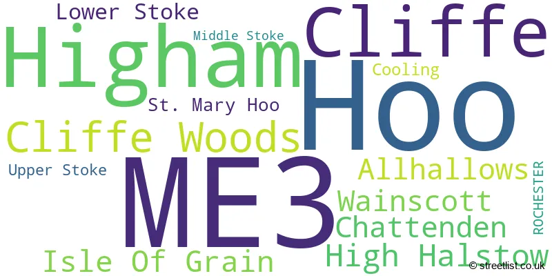
The largest settlement in the ME3 postal code is Hoo followed by Higham, and Cliffe.
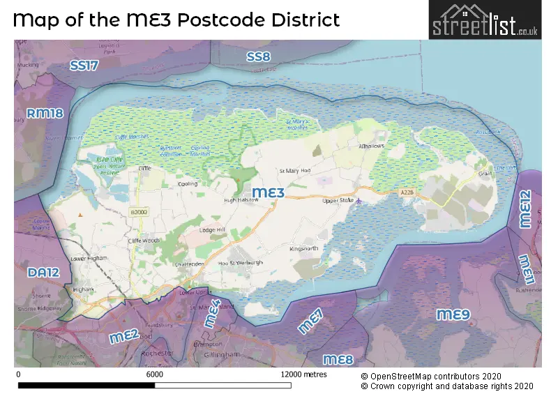
The postcode area has a boundary with Tidal Thames and Thames Estuary.
The ME3 Postcode shares a border with ME2 (ROCHESTER, Halling, Strood) and DA12 (GRAVESEND, Shorne, Cobham).
In the ME3 postcode district in the county of Kent, the primary settlement is Isle Of Grain. Other significant settlements include Cliffe, Cliffe Woods, Higham, Rochester, Chattenden, Cooling, High Halstow, St. Mary Hoo, and Wainscott. The main post town in this district is Rochester.
For the district ME3, we have data on 4 postcode sectors. Here's a breakdown: The sector ME3 0, covers Isle Of Grain in Kent. The sector ME3 7, covers Higham and Cliffe in Kent. The sector ME3 8, covers Cliffe Woods and High Halstow and Chattenden and Wainscott in Kent. The sector ME3 9, covers Hoo and Allhallows in Kent.

Map of the ME3 Postcode District
Explore the ME3 postcode district by using our free interactive map.
When it comes to local government, postal geography often disregards political borders. However, for a breakdown in the ME3 District: the district mostly encompasses the Medway (B) (720 postcodes), and finally, the Gravesham District (B) area (127 postcodes).
Recent House Sales in ME3
| Date | Price | Address |
|---|---|---|
| 19/10/2023 | £550,000 | Bells Lane, Hoo, Rochester, ME3 9HY |
| 02/10/2023 | £250,000 | Hermitage Road, Higham, Rochester, ME3 7ND |
| 28/09/2023 | £861,500 | Charles Dickens Avenue, Higham, Rochester, ME3 7NL |
| 25/09/2023 | £525,000 | Marsh Crescent, High Halstow, Rochester, ME3 8TJ |
| 14/09/2023 | £230,000 | Rookery Crescent, Cliffe, Rochester, ME3 7RH |
| 12/09/2023 | £510,000 | High View, Higham, Rochester, ME3 7HR |
| 06/09/2023 | £325,000 | Trubridge Road, Hoo, Rochester, ME3 9EW |
| 04/09/2023 | £375,000 | Queensway, Allhallows, Rochester, ME3 9QB |
| 31/08/2023 | £390,000 | Cagney Close, Wainscott, Rochester, ME3 8AY |
| 30/08/2023 | £170,000 | Willow Grange, Hoo, Rochester, ME3 9HS |
Where is the ME3 Postcode District?
The postcode district ME3 is located in Rochester. It is situated near several towns: Canvey Island to the north, Gillingham to the south, Stanford-le-Hope to the northwest, Leigh-on-Sea to the northeast, Queenborough to the east, and Gravesend to the west. Furthermore, this district is about 30.1 miles away from the center of London.
The district is within the post town of ROCHESTER.
The sector has postcodes within the nation of England.
The ME3 Postcode District is covers the following regions.
- Medway - Kent - South East (England)
- Kent Thames Gateway - Kent - South East (England)
Weather Forecast for ME3
Press Button to Show Forecast for Kingsnorth
| Time Period | Icon | Description | Temperature | Rain Probability | Wind |
|---|---|---|---|---|---|
| 12:00 to 15:00 | Partly cloudy (day) | 19.0°C (feels like 17.0°C) | 1.00% | ENE 13 mph | |
| 15:00 to 18:00 | Sunny day | 19.0°C (feels like 16.0°C) | 1.00% | ENE 13 mph | |
| 18:00 to 21:00 | Partly cloudy (day) | 19.0°C (feels like 17.0°C) | 1.00% | E 9 mph | |
| 21:00 to 00:00 | Partly cloudy (night) | 16.0°C (feels like 15.0°C) | 1.00% | SE 4 mph |
Press Button to Show Forecast for Kingsnorth
| Time Period | Icon | Description | Temperature | Rain Probability | Wind |
|---|---|---|---|---|---|
| 00:00 to 03:00 | Partly cloudy (night) | 15.0°C (feels like 15.0°C) | 3.00% | SW 7 mph | |
| 03:00 to 06:00 | Clear night | 14.0°C (feels like 13.0°C) | 2.00% | SSW 7 mph | |
| 06:00 to 09:00 | Partly cloudy (day) | 14.0°C (feels like 12.0°C) | 3.00% | SSW 9 mph | |
| 09:00 to 12:00 | Partly cloudy (day) | 17.0°C (feels like 15.0°C) | 2.00% | SSW 11 mph | |
| 12:00 to 15:00 | Partly cloudy (day) | 19.0°C (feels like 17.0°C) | 1.00% | S 11 mph | |
| 15:00 to 18:00 | Partly cloudy (day) | 19.0°C (feels like 17.0°C) | 1.00% | S 13 mph | |
| 18:00 to 21:00 | Cloudy | 18.0°C (feels like 16.0°C) | 5.00% | SSE 9 mph | |
| 21:00 to 00:00 | Cloudy | 15.0°C (feels like 14.0°C) | 7.00% | ESE 11 mph |
Press Button to Show Forecast for Kingsnorth
| Time Period | Icon | Description | Temperature | Rain Probability | Wind |
|---|---|---|---|---|---|
| 00:00 to 03:00 | Cloudy | 15.0°C (feels like 13.0°C) | 7.00% | SE 9 mph | |
| 03:00 to 06:00 | Cloudy | 15.0°C (feels like 14.0°C) | 12.00% | SE 9 mph | |
| 06:00 to 09:00 | Cloudy | 15.0°C (feels like 13.0°C) | 20.00% | ESE 9 mph | |
| 09:00 to 12:00 | Heavy rain | 16.0°C (feels like 14.0°C) | 72.00% | SE 11 mph | |
| 12:00 to 15:00 | Heavy rain | 16.0°C (feels like 14.0°C) | 74.00% | SSE 11 mph | |
| 15:00 to 18:00 | Heavy rain shower (day) | 16.0°C (feels like 14.0°C) | 62.00% | S 11 mph | |
| 18:00 to 21:00 | Cloudy | 16.0°C (feels like 14.0°C) | 19.00% | SSE 9 mph | |
| 21:00 to 00:00 | Cloudy | 14.0°C (feels like 13.0°C) | 9.00% | SE 9 mph |
Press Button to Show Forecast for Kingsnorth
| Time Period | Icon | Description | Temperature | Rain Probability | Wind |
|---|---|---|---|---|---|
| 00:00 to 03:00 | Cloudy | 14.0°C (feels like 12.0°C) | 8.00% | SE 9 mph | |
| 03:00 to 06:00 | Cloudy | 13.0°C (feels like 12.0°C) | 11.00% | SE 7 mph | |
| 06:00 to 09:00 | Partly cloudy (day) | 14.0°C (feels like 13.0°C) | 11.00% | SSE 7 mph | |
| 09:00 to 12:00 | Partly cloudy (day) | 16.0°C (feels like 15.0°C) | 11.00% | SSE 9 mph | |
| 12:00 to 15:00 | Partly cloudy (day) | 17.0°C (feels like 16.0°C) | 9.00% | SSE 9 mph | |
| 15:00 to 18:00 | Partly cloudy (day) | 18.0°C (feels like 16.0°C) | 5.00% | SSE 9 mph | |
| 18:00 to 21:00 | Sunny day | 17.0°C (feels like 16.0°C) | 5.00% | SE 7 mph | |
| 21:00 to 00:00 | Clear night | 14.0°C (feels like 13.0°C) | 1.00% | SE 7 mph |
Press Button to Show Forecast for Kingsnorth
| Time Period | Icon | Description | Temperature | Rain Probability | Wind |
|---|---|---|---|---|---|
| 00:00 to 03:00 | Clear night | 13.0°C (feels like 12.0°C) | 1.00% | SE 7 mph | |
| 03:00 to 06:00 | Partly cloudy (night) | 12.0°C (feels like 11.0°C) | 3.00% | ESE 4 mph | |
| 06:00 to 09:00 | Partly cloudy (day) | 13.0°C (feels like 13.0°C) | 4.00% | SE 4 mph | |
| 09:00 to 12:00 | Partly cloudy (day) | 16.0°C (feels like 16.0°C) | 5.00% | SSE 4 mph | |
| 12:00 to 15:00 | Cloudy | 18.0°C (feels like 17.0°C) | 14.00% | SSE 7 mph | |
| 15:00 to 18:00 | Cloudy | 18.0°C (feels like 17.0°C) | 14.00% | SSW 7 mph | |
| 18:00 to 21:00 | Partly cloudy (day) | 18.0°C (feels like 16.0°C) | 8.00% | SSW 7 mph | |
| 21:00 to 00:00 | Cloudy | 15.0°C (feels like 14.0°C) | 7.00% | SW 7 mph |
| Postcode Sector | Delivery Office |
|---|---|
| ME3 0 | Rochester Delivery Office |
| ME3 0 | Lowerstoke Scale Payment Delivery Office |
| ME3 7 | Rochester Delivery Office |
| ME3 8 | Rochester Delivery Office |
| ME3 9 | Rochester Delivery Office |
| ME3 9 | Lowerstoke Scale Payment Delivery Office |
| ME3 9 | Hoo Scale Payment Delivery Office |
| M | E | 3 | - | X | X | X |
| M | E | 3 | Space | Numeric | Letter | Letter |
Tourist Attractions within the ME3 Postcode Area
We found 1 visitor attractions within the ME3 postcode area
| St James Cooling |
|---|
| Historic Properties |
| Other Historic Property |
| View St James Cooling on Google Maps |
Current Monthly Rental Prices
| # Bedrooms | Min Price | Max Price | Avg Price |
|---|---|---|---|
| 1 | £650 | £900 | £775 |
| 2 | £1,050 | £1,050 | £1,050 |
| 3 | £1,500 | £1,600 | £1,575 |
| 4 | £2,500 | £2,500 | £2,500 |
| 6 | £2,700 | £2,700 | £2,700 |
Current House Prices
| # Bedrooms | Min Price | Max Price | Avg Price |
|---|---|---|---|
| £150,000 | £260,000 | £198,333 | |
| 1 | £105,000 | £180,000 | £138,750 |
| 2 | £120,000 | £425,000 | £248,646 |
| 3 | £30,000 | £999,995 | £378,780 |
| 4 | £265,000 | £950,000 | £545,178 |
| 5 | £500,000 | £1,800,000 | £868,329 |
| 6 | £600,000 | £640,000 | £613,333 |
| 8 | £400,000 | £400,000 | £400,000 |
Estate Agents who Operate in the ME3 District
| Logo | Name | Brand Name | Address | Contact Number | Total Properties |
|---|---|---|---|---|---|
 | Hoo | Your Move | 13A Main Road, Hoo, Kent, ME3 9AA | 01634 561269 | 22 |
 | Strood | Wards | 86 High Street, Strood, Rochester, Kent, ME2 4AT | 01634 563335 | 19 |
 | Covering Strood & Walderslade | EweMove | Hollywood House, 76 Hollywood Lane, Wainscott, Rochester, ME3 8AR | 01634 959292 | 12 |
 | Rochester | Moxy Property Consultants | 34 High Street Rochester Kent ME1 1PT | 01634 949987 | 9 |
 | Strood | Mann | 165 High Street, Strood, Kent, ME2 4TH | 01634 563484 | 8 |
Yearly House Price Averages for the ME3 Postcode District
| Type of Property | 2018 Average | 2018 Sales | 2017 Average | 2017 Sales | 2016 Average | 2016 Sales | 2015 Average | 2015 Sales |
|---|---|---|---|---|---|---|---|---|
| Detached | £463,442 | 78 | £436,499 | 95 | £403,415 | 107 | £370,318 | 113 |
| Semi-Detached | £296,264 | 183 | £287,720 | 176 | £275,624 | 190 | £245,736 | 199 |
| Terraced | £254,384 | 111 | £253,570 | 109 | £224,996 | 147 | £216,987 | 181 |
| Flats | £170,761 | 31 | £171,224 | 29 | £143,410 | 36 | £150,829 | 59 |