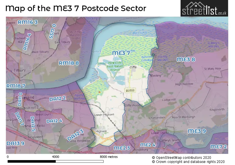
The ME3 7 postcode sector is within the county of Kent.
Did you know? According to the 2021 Census, the ME3 7 postcode sector is home to a bustling 6,636 residents!
Given that each sector allows for 400 unique postcode combinations. Letters C, I, K, M, O and V are not allowed in the last two letters of a postcode. With 220 postcodes already in use, this leaves 180 units available.
The largest settlement in the ME3 7 postal code is Higham followed by Cliffe, and Cliffe Woods.
The ME3 7 Postcode shares a border with ME2 3 (ROCHESTER, Strood), DA12 3 (Shorne, Cobham) and ME3 8 (Cliffe Woods, Chattenden, Wainscott).
The sector is within the post town of ROCHESTER.
ME3 7 is a postcode sector within the ME3 postcode district which is within the ME Medway postcode area.
The Royal Mail delivery office for the ME3 7 postal sector is the Rochester Delivery Office.
The area of the ME3 7 postcode sector is 13.31 square miles which is 34.47 square kilometres or 8,517.85 square acres.
Waterways within the ME3 7 postcode sector include the Thames and Medway Canal (Disused), Thames and Medway Canal.

Map of the ME3 7 Postcode Sector
Explore the ME3 7 postcode sector by using our free interactive map.
| M | E | 3 | - | 7 | X | X |
| M | E | 3 | Space | 7 | Letter | Letter |
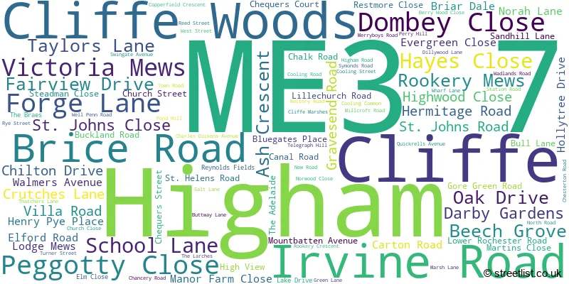
Official List of Streets
Higham (52 Streets)
Cliffe Woods (3 Streets)
Cliffe (42 Streets)
Unofficial Streets or Alternative Spellings
Weather Forecast for ME3 7
Press Button to Show Forecast for Strood
| Time Period | Icon | Description | Temperature | Rain Probability | Wind |
|---|---|---|---|---|---|
| 15:00 to 18:00 | Light rain | 15.0°C (feels like 13.0°C) | 48.00% | SSE 9 mph | |
| 18:00 to 21:00 | Cloudy | 14.0°C (feels like 13.0°C) | 10.00% | SE 7 mph | |
| 21:00 to 00:00 | Cloudy | 13.0°C (feels like 12.0°C) | 8.00% | SE 7 mph |
Press Button to Show Forecast for Strood
| Time Period | Icon | Description | Temperature | Rain Probability | Wind |
|---|---|---|---|---|---|
| 00:00 to 03:00 | Cloudy | 13.0°C (feels like 12.0°C) | 13.00% | SE 7 mph | |
| 03:00 to 06:00 | Cloudy | 13.0°C (feels like 12.0°C) | 16.00% | SE 7 mph | |
| 06:00 to 09:00 | Cloudy | 13.0°C (feels like 13.0°C) | 15.00% | SE 4 mph | |
| 09:00 to 12:00 | Cloudy | 15.0°C (feels like 14.0°C) | 18.00% | SE 4 mph | |
| 12:00 to 15:00 | Cloudy | 16.0°C (feels like 15.0°C) | 44.00% | SE 7 mph | |
| 15:00 to 18:00 | Cloudy | 17.0°C (feels like 16.0°C) | 18.00% | SE 7 mph | |
| 18:00 to 21:00 | Cloudy | 16.0°C (feels like 15.0°C) | 17.00% | SE 4 mph | |
| 21:00 to 00:00 | Cloudy | 13.0°C (feels like 13.0°C) | 11.00% | SE 4 mph |
Press Button to Show Forecast for Strood
| Time Period | Icon | Description | Temperature | Rain Probability | Wind |
|---|---|---|---|---|---|
| 00:00 to 03:00 | Cloudy | 12.0°C (feels like 11.0°C) | 7.00% | S 4 mph | |
| 03:00 to 06:00 | Cloudy | 11.0°C (feels like 11.0°C) | 10.00% | S 4 mph | |
| 06:00 to 09:00 | Cloudy | 12.0°C (feels like 12.0°C) | 14.00% | SSE 2 mph | |
| 09:00 to 12:00 | Cloudy | 16.0°C (feels like 16.0°C) | 13.00% | S 2 mph | |
| 12:00 to 15:00 | Cloudy | 18.0°C (feels like 17.0°C) | 12.00% | S 4 mph | |
| 15:00 to 18:00 | Cloudy | 17.0°C (feels like 17.0°C) | 15.00% | SSW 4 mph | |
| 18:00 to 21:00 | Cloudy | 16.0°C (feels like 16.0°C) | 15.00% | SSE 4 mph | |
| 21:00 to 00:00 | Cloudy | 14.0°C (feels like 13.0°C) | 12.00% | SW 4 mph |
Press Button to Show Forecast for Strood
| Time Period | Icon | Description | Temperature | Rain Probability | Wind |
|---|---|---|---|---|---|
| 00:00 to 03:00 | Partly cloudy (night) | 13.0°C (feels like 12.0°C) | 6.00% | WSW 4 mph | |
| 03:00 to 06:00 | Cloudy | 12.0°C (feels like 11.0°C) | 8.00% | WSW 4 mph | |
| 06:00 to 09:00 | Partly cloudy (day) | 13.0°C (feels like 12.0°C) | 9.00% | WSW 4 mph | |
| 09:00 to 12:00 | Partly cloudy (day) | 16.0°C (feels like 15.0°C) | 10.00% | WSW 4 mph | |
| 12:00 to 15:00 | Partly cloudy (day) | 18.0°C (feels like 17.0°C) | 16.00% | W 7 mph | |
| 15:00 to 18:00 | Light rain shower (day) | 19.0°C (feels like 18.0°C) | 38.00% | W 7 mph | |
| 18:00 to 21:00 | Light rain shower (day) | 18.0°C (feels like 17.0°C) | 36.00% | W 4 mph | |
| 21:00 to 00:00 | Cloudy | 15.0°C (feels like 14.0°C) | 13.00% | SW 4 mph |
Press Button to Show Forecast for Strood
| Time Period | Icon | Description | Temperature | Rain Probability | Wind |
|---|---|---|---|---|---|
| 00:00 to 03:00 | Cloudy | 13.0°C (feels like 13.0°C) | 8.00% | W 4 mph | |
| 03:00 to 06:00 | Cloudy | 12.0°C (feels like 11.0°C) | 12.00% | WNW 7 mph | |
| 06:00 to 09:00 | Cloudy | 13.0°C (feels like 12.0°C) | 12.00% | WNW 7 mph | |
| 09:00 to 12:00 | Cloudy | 15.0°C (feels like 14.0°C) | 14.00% | NW 7 mph | |
| 12:00 to 15:00 | Light rain shower (day) | 17.0°C (feels like 16.0°C) | 33.00% | NW 7 mph | |
| 15:00 to 18:00 | Light rain shower (day) | 18.0°C (feels like 16.0°C) | 37.00% | NNW 9 mph | |
| 18:00 to 21:00 | Light rain shower (day) | 17.0°C (feels like 16.0°C) | 32.00% | NNW 7 mph | |
| 21:00 to 00:00 | Clear night | 14.0°C (feels like 13.0°C) | 5.00% | N 7 mph |
Schools and Places of Education Within the ME3 7 Postcode Sector
Higham Primary School
Community school
School Lane, Rochester, Kent, ME3 7JL
Head: Mrs Catherine Grattan
Ofsted Rating: Good
Inspection: 2018-06-06 (2169 days ago)
Website: Visit Higham Primary School Website
Phone: 01474822535
Number of Pupils: 208
St Helen's Church of England Primary School, Cliffe
Voluntary controlled school
Church Street, Rochester, Kent, ME3 7PU
Head: Mrs Stephanie Jarvis
Ofsted Rating: Good
Inspection: 2019-06-04 (1806 days ago)
Website: Visit St Helen's Church of England Primary School, Cliffe Website
Phone: 01634220246
Number of Pupils: 211
House Prices in the ME3 7 Postcode Sector
| Type of Property | 2018 Average | 2018 Sales | 2017 Average | 2017 Sales | 2016 Average | 2016 Sales | 2015 Average | 2015 Sales |
|---|---|---|---|---|---|---|---|---|
| Detached | £495,938 | 24 | £541,722 | 18 | £549,143 | 14 | £495,348 | 23 |
| Semi-Detached | £321,729 | 35 | £306,030 | 41 | £303,934 | 41 | £278,169 | 39 |
| Terraced | £263,125 | 20 | £292,516 | 17 | £247,299 | 29 | £222,239 | 28 |
| Flats | £154,500 | 2 | £168,500 | 1 | £77,500 | 1 | £128,625 | 4 |
Important Postcodes ME3 7 in the Postcode Sector
ME3 7DB is the postcode for Highcliffe Medical Practice, 14 Hermitage Road
ME3 7JL is the postcode for Higham Primary School, School Lane, Higham, OLD SCHOOL, Higham Primary School, School Lane, OLD SCHOOL, Higham Cp School, School Lane, and Higham Cp School, School Lane
ME3 7PU is the postcode for St. Helens C of E Primary School, Church Street, Cliffe, and St. Helens C of E Primary School, Church Street
| The ME3 7 Sector is within these Local Authorities |
|
|---|---|
| The ME3 7 Sector is within these Counties |
|
| The ME3 7 Sector is within these Water Company Areas |
|