The DA12 3 postcode sector is within the county of Kent.
Did you know? According to the 2021 Census, the DA12 3 postcode sector is home to a bustling 2,298 residents!
Given that each sector allows for 400 unique postcode combinations. Letters C, I, K, M, O and V are not allowed in the last two letters of a postcode. With 94 postcodes already in use, this leaves 306 units available.
The largest settlements in the DA12 3 postal code are Shorne and Cobham.
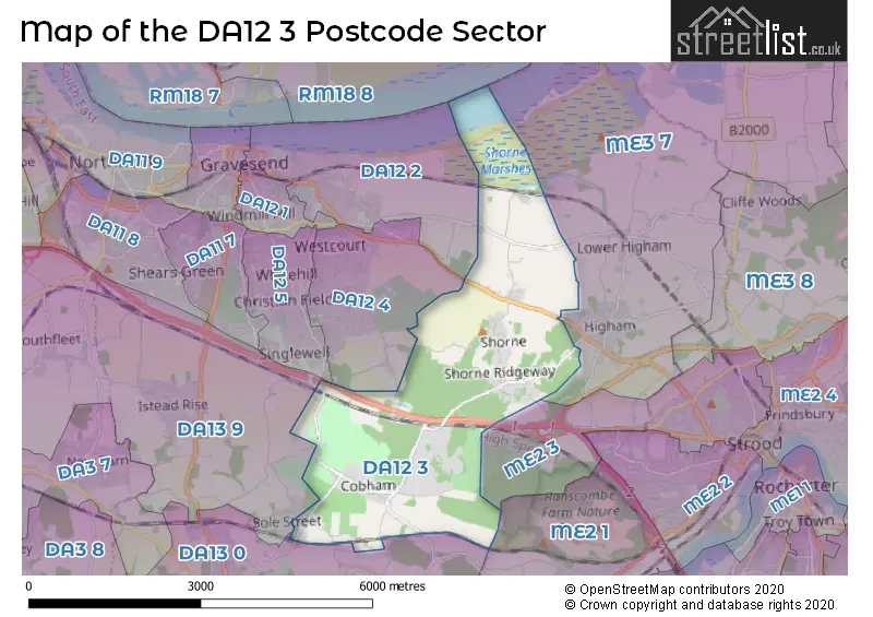
The DA12 3 Postcode shares a border with DA12 2 (GRAVESEND), DA12 5 (GRAVESEND), DA13 0 (Meopham, Vigo, Luddesdown), DA13 9 (Istead Rise, Southfleet, Cobham), ME2 1 (Halling, Cuxton, Upper Halling), ME2 3 (ROCHESTER, Strood), DA12 4 (GRAVESEND) and ME3 7 (Higham, Cliffe, Cliffe Woods).
The sector is within the post town of GRAVESEND.
DA12 3 is a postcode sector within the DA12 postcode district which is within the DA Dartford postcode area.
The Royal Mail delivery office for the DA12 3 postal sector is the Gravesend Delivery Office.
The area of the DA12 3 postcode sector is 6.72 square miles which is 17.39 square kilometres or 4,298.25 square acres.
The DA12 3 postcode sector is crossed by the A2 Major A road.
Waterways within the DA12 3 postcode sector include the Thames and Medway Canal.

Map of the DA12 3 Postcode Sector
Explore the DA12 3 postcode sector by using our free interactive map.
| D | A | 1 | 2 | - | 3 | X | X |
| D | A | 1 | 2 | Space | 3 | Letter | Letter |
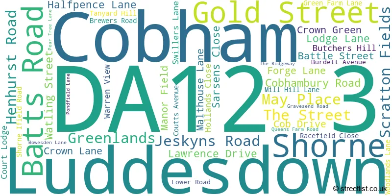
Official List of Streets
Cobham (13 Streets)
Luddesdown (1 Streets)
Shorne (29 Streets)
Unofficial Streets or Alternative Spellings
Shorne
THONG LANEHigham
GRAVESEND ROAD WALMERS AVENUECobham
CHURCH ROAD MANOR ROAD ROUND STREET BARNDALE COURT CARDIAC HILL DONT FORGET THE GATE GRUNTLY AND PALMER I AINT DOIN THAT LOWER THAMES CROSSING (ROADS SOUTH) MINI WEAVER MUGGINS LANE PALE PARK LANE PEARTREE LANE PRIVATE PURPLE CIRCULAR WALK RED CIRCULAR WALK RIO ROUND THE BOWL SCOTLAND LANE SOLE STREET THE DRAIN WALNUTSBean
WATLING STREETGRAVESEND
LOWER HIGHAM ROADROCHESTER
PARK PALEWeather Forecast for DA12 3
Press Button to Show Forecast for Strood
| Time Period | Icon | Description | Temperature | Rain Probability | Wind |
|---|---|---|---|---|---|
| 21:00 to 00:00 | Cloudy | 8.0°C (feels like 6.0°C) | 10.00% | E 9 mph |
Press Button to Show Forecast for Strood
| Time Period | Icon | Description | Temperature | Rain Probability | Wind |
|---|---|---|---|---|---|
| 00:00 to 03:00 | Heavy rain | 8.0°C (feels like 5.0°C) | 88.00% | E 9 mph | |
| 03:00 to 06:00 | Light rain | 7.0°C (feels like 4.0°C) | 61.00% | NE 9 mph | |
| 06:00 to 09:00 | Heavy rain | 7.0°C (feels like 5.0°C) | 83.00% | NE 11 mph | |
| 09:00 to 12:00 | Overcast | 9.0°C (feels like 7.0°C) | 44.00% | ENE 9 mph | |
| 12:00 to 15:00 | Cloudy | 11.0°C (feels like 9.0°C) | 55.00% | ENE 9 mph | |
| 15:00 to 18:00 | Cloudy | 12.0°C (feels like 10.0°C) | 13.00% | ENE 11 mph | |
| 18:00 to 21:00 | Light rain | 11.0°C (feels like 8.0°C) | 53.00% | ENE 11 mph | |
| 21:00 to 00:00 | Heavy rain | 10.0°C (feels like 7.0°C) | 91.00% | NE 11 mph |
Press Button to Show Forecast for Strood
| Time Period | Icon | Description | Temperature | Rain Probability | Wind |
|---|---|---|---|---|---|
| 00:00 to 03:00 | Heavy rain | 10.0°C (feels like 8.0°C) | 93.00% | NE 11 mph | |
| 03:00 to 06:00 | Heavy rain | 10.0°C (feels like 8.0°C) | 86.00% | E 9 mph | |
| 06:00 to 09:00 | Light rain | 10.0°C (feels like 8.0°C) | 55.00% | WSW 9 mph | |
| 09:00 to 12:00 | Light rain shower (day) | 11.0°C (feels like 8.0°C) | 53.00% | WSW 11 mph | |
| 12:00 to 15:00 | Light rain | 10.0°C (feels like 7.0°C) | 54.00% | W 13 mph | |
| 15:00 to 18:00 | Light rain | 11.0°C (feels like 8.0°C) | 42.00% | W 13 mph | |
| 18:00 to 21:00 | Cloudy | 11.0°C (feels like 9.0°C) | 8.00% | WSW 7 mph | |
| 21:00 to 00:00 | Partly cloudy (night) | 9.0°C (feels like 7.0°C) | 2.00% | SW 7 mph |
Press Button to Show Forecast for Strood
| Time Period | Icon | Description | Temperature | Rain Probability | Wind |
|---|---|---|---|---|---|
| 00:00 to 03:00 | Clear night | 7.0°C (feels like 5.0°C) | 2.00% | SSW 7 mph | |
| 03:00 to 06:00 | Clear night | 6.0°C (feels like 5.0°C) | 1.00% | SSW 7 mph | |
| 06:00 to 09:00 | Sunny day | 7.0°C (feels like 6.0°C) | 1.00% | S 7 mph | |
| 09:00 to 12:00 | Partly cloudy (day) | 12.0°C (feels like 10.0°C) | 10.00% | S 9 mph | |
| 12:00 to 15:00 | Partly cloudy (day) | 14.0°C (feels like 12.0°C) | 3.00% | S 11 mph | |
| 15:00 to 18:00 | Sunny day | 15.0°C (feels like 12.0°C) | 2.00% | S 11 mph | |
| 18:00 to 21:00 | Sunny day | 14.0°C (feels like 12.0°C) | 3.00% | SSE 9 mph | |
| 21:00 to 00:00 | Clear night | 10.0°C (feels like 8.0°C) | 1.00% | SSE 7 mph |
Press Button to Show Forecast for Strood
| Time Period | Icon | Description | Temperature | Rain Probability | Wind |
|---|---|---|---|---|---|
| 00:00 to 03:00 | Clear night | 9.0°C (feels like 7.0°C) | 1.00% | SE 7 mph | |
| 03:00 to 06:00 | Partly cloudy (night) | 8.0°C (feels like 6.0°C) | 2.00% | ESE 7 mph | |
| 06:00 to 09:00 | Cloudy | 9.0°C (feels like 8.0°C) | 8.00% | ESE 7 mph | |
| 09:00 to 12:00 | Cloudy | 13.0°C (feels like 12.0°C) | 6.00% | ESE 7 mph | |
| 12:00 to 15:00 | Cloudy | 15.0°C (feels like 14.0°C) | 9.00% | SE 9 mph | |
| 15:00 to 18:00 | Cloudy | 16.0°C (feels like 14.0°C) | 9.00% | ESE 9 mph | |
| 18:00 to 21:00 | Cloudy | 14.0°C (feels like 13.0°C) | 20.00% | ESE 9 mph | |
| 21:00 to 00:00 | Cloudy | 12.0°C (feels like 11.0°C) | 20.00% | E 9 mph |
Schools and Places of Education Within the DA12 3 Postcode Sector
Cobham Primary School
Community school
The Street, Gravesend, Kent, DA12 3BN
Head: Mrs Jacqui Saunders
Ofsted Rating: Outstanding
Inspection: 2012-11-15 (4180 days ago)
Website: Visit Cobham Primary School Website
Phone: 01474814373
Number of Pupils: 218
Shorne Church of England Primary School
Academy converter
Cob Drive, Gravesend, Kent, DA12 3DU
Head: Miss Tara Hewett
Ofsted Rating: Good
Inspection: 2023-03-08 (415 days ago)
Website: Visit Shorne Church of England Primary School Website
Phone: 01474822312
Number of Pupils: 209
House Prices in the DA12 3 Postcode Sector
| Type of Property | 2018 Average | 2018 Sales | 2017 Average | 2017 Sales | 2016 Average | 2016 Sales | 2015 Average | 2015 Sales |
|---|---|---|---|---|---|---|---|---|
| Detached | £643,063 | 32 | £696,671 | 14 | £601,563 | 8 | £641,125 | 16 |
| Semi-Detached | £509,000 | 2 | £494,000 | 5 | £445,455 | 11 | £294,167 | 6 |
| Terraced | £369,233 | 9 | £303,750 | 2 | £453,750 | 4 | £298,750 | 8 |
| Flats | £0 | 0 | £0 | 0 | £0 | 0 | £0 | 0 |
Important Postcodes DA12 3 in the Postcode Sector
DA12 3DU is the postcode for Shorne C of E Primary School, Cob Drive
DA12 3DY is the postcode for Downs Way Medical Practice, Crown Lane
DA12 3HX is the postcode for Shornewood Country Park, Brewers Road
| The DA12 3 Sector is within these Local Authorities |
|
|---|---|
| The DA12 3 Sector is within these Counties |
|
| The DA12 3 Sector is within these Water Company Areas |
|
Tourist Attractions within the DA12 3 Postcode Area
We found 2 visitor attractions within the DA12 postcode area
| Jeskyns |
|---|
| Country Parks |
| Country Park |
| View Jeskyns on Google Maps |
| Owletts - National Trust |
| Historic Properties |
| Historic House / House and Garden / Palace |
| View Owletts - National Trust on Google Maps |