The DE1 2 postcode sector is within the county of Derbyshire.
Did you know? According to the 2021 Census, the DE1 2 postcode sector is home to a bustling 2,581 residents!
Given that each sector allows for 400 unique postcode combinations. Letters C, I, K, M, O and V are not allowed in the last two letters of a postcode. With 172 postcodes already in use, this leaves 228 units available.
The DE1 2 postal code covers the settlement of DERBY.
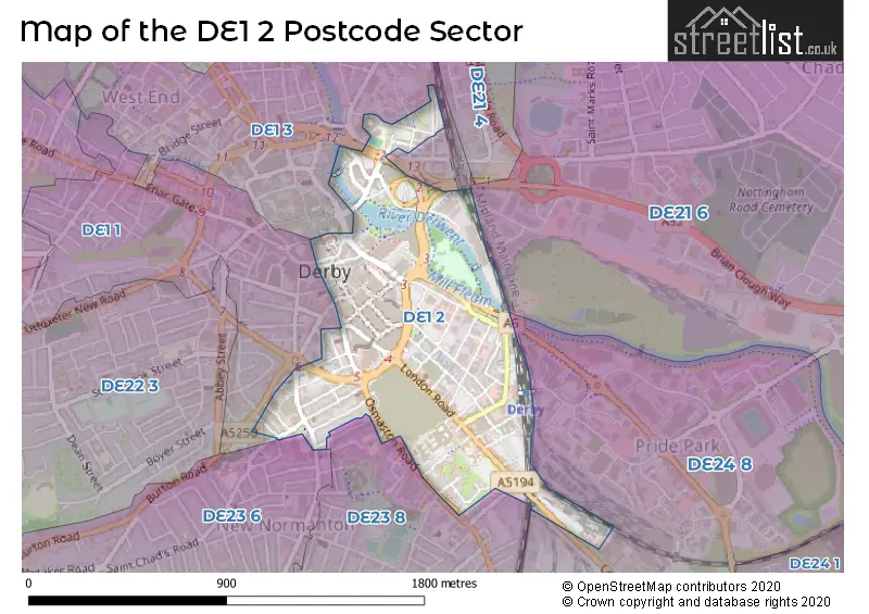
The DE1 2 Postcode shares a border with DE1 3 (DERBY), DE21 6 (Chaddesden, DERBY, West Meadows Industrial Estate), DE24 8 (DERBY, Alvaston, Allenton), DE1 1 (DERBY), DE23 6 (DERBY, Littleover) and DE23 8 (DERBY, Pear Tree).
The sector is within the post town of DERBY.
DE1 2 is a postcode sector within the DE1 postcode district which is within the DE Derby postcode area.
The Royal Mail delivery office for the DE1 2 postal sector is the Derby Town Delivery Office.
The area of the DE1 2 postcode sector is 0.50 square miles which is 1.30 square kilometres or 320.86 square acres.
Waterways within the DE1 2 postcode sector include the River Derwent, Mill Fleam.

Map of the DE1 2 Postcode Sector
Explore the DE1 2 postcode sector by using our free interactive map.
| D | E | 1 | - | 2 | X | X |
| D | E | 1 | Space | 2 | Letter | Letter |
Official List of Streets
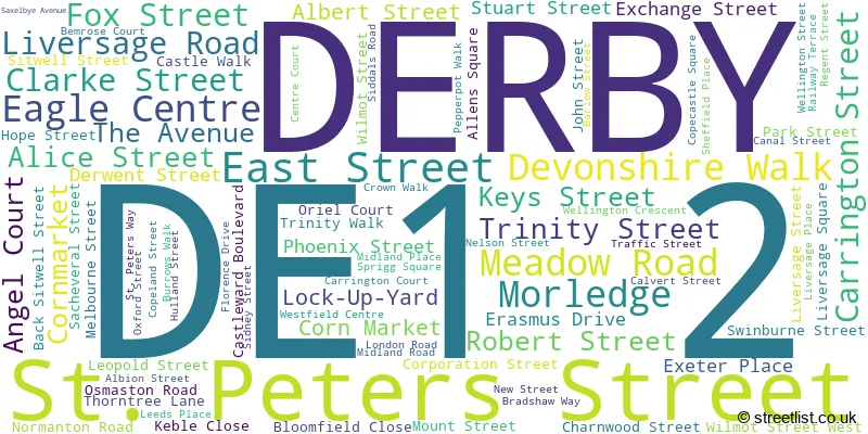
DERBY (84 Streets)
Unofficial Streets or Alternative Spellings
Chaddesden
NOTTINGHAM ROADAlvaston
LONDON ROADDERBY
BATEMAN STREET HARTINGTON STREET LEONARD STREET LITCHURCH LANE MARKET PLACE MILL HILL LANE SACHEVERAL STREET VICTORIA STREET WELLINGTON CRESCENT WOOD STREETWest Meadows Industrial Estate
CRANMER ROADWeather Forecast for DE1 2
Press Button to Show Forecast for Derby
| Time Period | Icon | Description | Temperature | Rain Probability | Wind |
|---|---|---|---|---|---|
| 03:00 to 06:00 | Heavy rain | 15.0°C (feels like 14.0°C) | 95.00% | ESE 9 mph | |
| 06:00 to 09:00 | Heavy rain | 15.0°C (feels like 13.0°C) | 96.00% | ESE 9 mph | |
| 09:00 to 12:00 | Light rain | 15.0°C (feels like 14.0°C) | 95.00% | SE 9 mph | |
| 12:00 to 15:00 | Light rain | 15.0°C (feels like 13.0°C) | 51.00% | SSE 9 mph | |
| 15:00 to 18:00 | Cloudy | 15.0°C (feels like 14.0°C) | 14.00% | SE 9 mph | |
| 18:00 to 21:00 | Cloudy | 16.0°C (feels like 14.0°C) | 10.00% | ESE 9 mph | |
| 21:00 to 00:00 | Cloudy | 14.0°C (feels like 12.0°C) | 6.00% | ESE 9 mph |
Press Button to Show Forecast for Derby
| Time Period | Icon | Description | Temperature | Rain Probability | Wind |
|---|---|---|---|---|---|
| 00:00 to 03:00 | Cloudy | 13.0°C (feels like 12.0°C) | 5.00% | ESE 7 mph | |
| 03:00 to 06:00 | Cloudy | 13.0°C (feels like 11.0°C) | 19.00% | E 7 mph | |
| 06:00 to 09:00 | Cloudy | 13.0°C (feels like 12.0°C) | 48.00% | E 7 mph | |
| 09:00 to 12:00 | Light rain | 15.0°C (feels like 14.0°C) | 44.00% | E 7 mph | |
| 12:00 to 15:00 | Light rain | 16.0°C (feels like 15.0°C) | 49.00% | E 9 mph | |
| 15:00 to 18:00 | Heavy rain | 16.0°C (feels like 15.0°C) | 86.00% | E 7 mph | |
| 18:00 to 21:00 | Heavy rain shower (day) | 15.0°C (feels like 14.0°C) | 68.00% | E 7 mph | |
| 21:00 to 00:00 | Cloudy | 13.0°C (feels like 13.0°C) | 15.00% | E 4 mph |
Press Button to Show Forecast for Derby
| Time Period | Icon | Description | Temperature | Rain Probability | Wind |
|---|---|---|---|---|---|
| 00:00 to 03:00 | Cloudy | 12.0°C (feels like 12.0°C) | 44.00% | E 2 mph | |
| 03:00 to 06:00 | Fog | 11.0°C (feels like 11.0°C) | 30.00% | ESE 2 mph | |
| 06:00 to 09:00 | Fog | 12.0°C (feels like 12.0°C) | 18.00% | NNW 2 mph | |
| 09:00 to 12:00 | Cloudy | 15.0°C (feels like 16.0°C) | 9.00% | SE 2 mph | |
| 12:00 to 15:00 | Cloudy | 18.0°C (feels like 17.0°C) | 13.00% | S 4 mph | |
| 15:00 to 18:00 | Cloudy | 18.0°C (feels like 18.0°C) | 15.00% | SSE 4 mph | |
| 18:00 to 21:00 | Cloudy | 17.0°C (feels like 17.0°C) | 18.00% | WNW 4 mph | |
| 21:00 to 00:00 | Cloudy | 15.0°C (feels like 14.0°C) | 16.00% | NW 4 mph |
Press Button to Show Forecast for Derby
| Time Period | Icon | Description | Temperature | Rain Probability | Wind |
|---|---|---|---|---|---|
| 00:00 to 03:00 | Partly cloudy (night) | 13.0°C (feels like 13.0°C) | 11.00% | NNW 7 mph | |
| 03:00 to 06:00 | Cloudy | 12.0°C (feels like 11.0°C) | 11.00% | NNW 7 mph | |
| 06:00 to 09:00 | Cloudy | 13.0°C (feels like 12.0°C) | 10.00% | NNW 4 mph | |
| 09:00 to 12:00 | Overcast | 15.0°C (feels like 14.0°C) | 14.00% | WNW 7 mph | |
| 12:00 to 15:00 | Light rain shower (day) | 18.0°C (feels like 17.0°C) | 32.00% | WNW 7 mph | |
| 15:00 to 18:00 | Light rain shower (day) | 19.0°C (feels like 18.0°C) | 38.00% | W 7 mph | |
| 18:00 to 21:00 | Light rain shower (day) | 18.0°C (feels like 17.0°C) | 33.00% | WNW 7 mph | |
| 21:00 to 00:00 | Clear night | 14.0°C (feels like 14.0°C) | 7.00% | NNW 7 mph |
Press Button to Show Forecast for Derby
| Time Period | Icon | Description | Temperature | Rain Probability | Wind |
|---|---|---|---|---|---|
| 00:00 to 03:00 | Cloudy | 13.0°C (feels like 12.0°C) | 7.00% | NW 7 mph | |
| 03:00 to 06:00 | Cloudy | 12.0°C (feels like 10.0°C) | 7.00% | N 7 mph | |
| 06:00 to 09:00 | Overcast | 12.0°C (feels like 11.0°C) | 12.00% | N 9 mph | |
| 09:00 to 12:00 | Overcast | 15.0°C (feels like 14.0°C) | 12.00% | NNE 9 mph | |
| 12:00 to 15:00 | Cloudy | 18.0°C (feels like 17.0°C) | 12.00% | NNE 9 mph | |
| 15:00 to 18:00 | Light rain shower (day) | 19.0°C (feels like 17.0°C) | 33.00% | NNE 9 mph | |
| 18:00 to 21:00 | Partly cloudy (day) | 17.0°C (feels like 16.0°C) | 13.00% | NE 9 mph | |
| 21:00 to 00:00 | Clear night | 14.0°C (feels like 13.0°C) | 5.00% | NNE 9 mph |
Schools and Places of Education Within the DE1 2 Postcode Sector
Landau Forte College
Academy sponsor led
Fox Street, Derby, Derbyshire, DE1 2LF
Head: Ms Alison Brannick
Ofsted Rating: Outstanding
Inspection: 2012-05-03 (4394 days ago)
Website: Visit Landau Forte College Website
Phone: 01332204040
Number of Pupils: 1198
House Prices in the DE1 2 Postcode Sector
| Type of Property | 2018 Average | 2018 Sales | 2017 Average | 2017 Sales | 2016 Average | 2016 Sales | 2015 Average | 2015 Sales |
|---|---|---|---|---|---|---|---|---|
| Detached | £247,000 | 1 | £0 | 0 | £243,360 | 5 | £142,950 | 1 |
| Semi-Detached | £155,700 | 5 | £136,500 | 2 | £0 | 0 | £153,380 | 10 |
| Terraced | £129,401 | 10 | £142,659 | 16 | £164,502 | 23 | £179,121 | 21 |
| Flats | £117,515 | 17 | £129,728 | 18 | £133,372 | 57 | £128,364 | 67 |
Important Postcodes DE1 2 in the Postcode Sector
DE1 2AZ is the postcode for Eagle Centre
DE1 2DB is the postcode for Market Hall
DE1 2EQ is the postcode for Derby Probation Trust, Derwent Court, Stuart Street
DE1 2FS is the postcode for Council House, Corporation Street, and Derby City Council, Council House, Corporation Street
DE1 2FZ is the postcode for Southern Derbyshire Health Authority, Stuart Street, Derwent Court
DE1 2GD is the postcode for Derby Walk in Centre, Osmaston Road
DE1 2GW is the postcode for 10 Normanton Road
DE1 2HF is the postcode for Derby Social Services, 42 Leopold Street
DE1 2LD is the postcode for D C C County Transport, Liversage Street
DE1 2LF is the postcode for BUILDING 1, Landau Forte College, Fox Street, BUILDING 2, Landau Forte College, Fox Street, and Landau Forte College, Fox Street
DE1 2NF is the postcode for Derby Theatre, 15 Theatre Walk, Westfield, and Derby Theatre, 15 Theatre Walk
DE1 2NT is the postcode for Castlewood Spencer Academy, Canal Street
DE1 2PB is the postcode for 2 Siddals Road
DE1 2QY is the postcode for RADIOTHERAPY, University Hospitals of Derby and Burton NHS Foundation Trust, London Road Community Hospital, Florence Nightingale Community Hospital, London Road, Derby Hospitals NHS Foundation Trust, Derbyshire Royal Infirmary, COMMUNITY, University Hospitals of Derby and Burton NHS Foundation Trust, London Road Community Hospital, PHASE 2, University Hospitals of Derby and Burton NHS Foundation Trust, London Road Community Hospital, University Hospitals of Derby and Burton NHS Foundation Trust, London Road Community Hospital, University Hospitals of Derby and Burton NHS Foundation Trust, London Road Community Hospital, London Road, University Hospitals of Derby and Burton NHS Foundation Trust, Florence Nightingale Community Hospital, London Road, Dovedale Day Hospital, London Road, and Derbyshire Healthcare NHS Foundation Trust, The Resource Centre
DE1 2TZ is the postcode for St. Andrews House, 201 London Road
DE1 2XE is the postcode for Derby Crown Court, Morledge, Derby Combined Court Centre, Morledge, and Derby Combined Court, Morledge
DE1 2XX is the postcode for South Derbyshire Health Authority, Dovedale Day Hospital, London Road
| The DE1 2 Sector is within these Local Authorities |
|
|---|---|
| The DE1 2 Sector is within these Counties |
|
| The DE1 2 Sector is within these Water Company Areas |
|